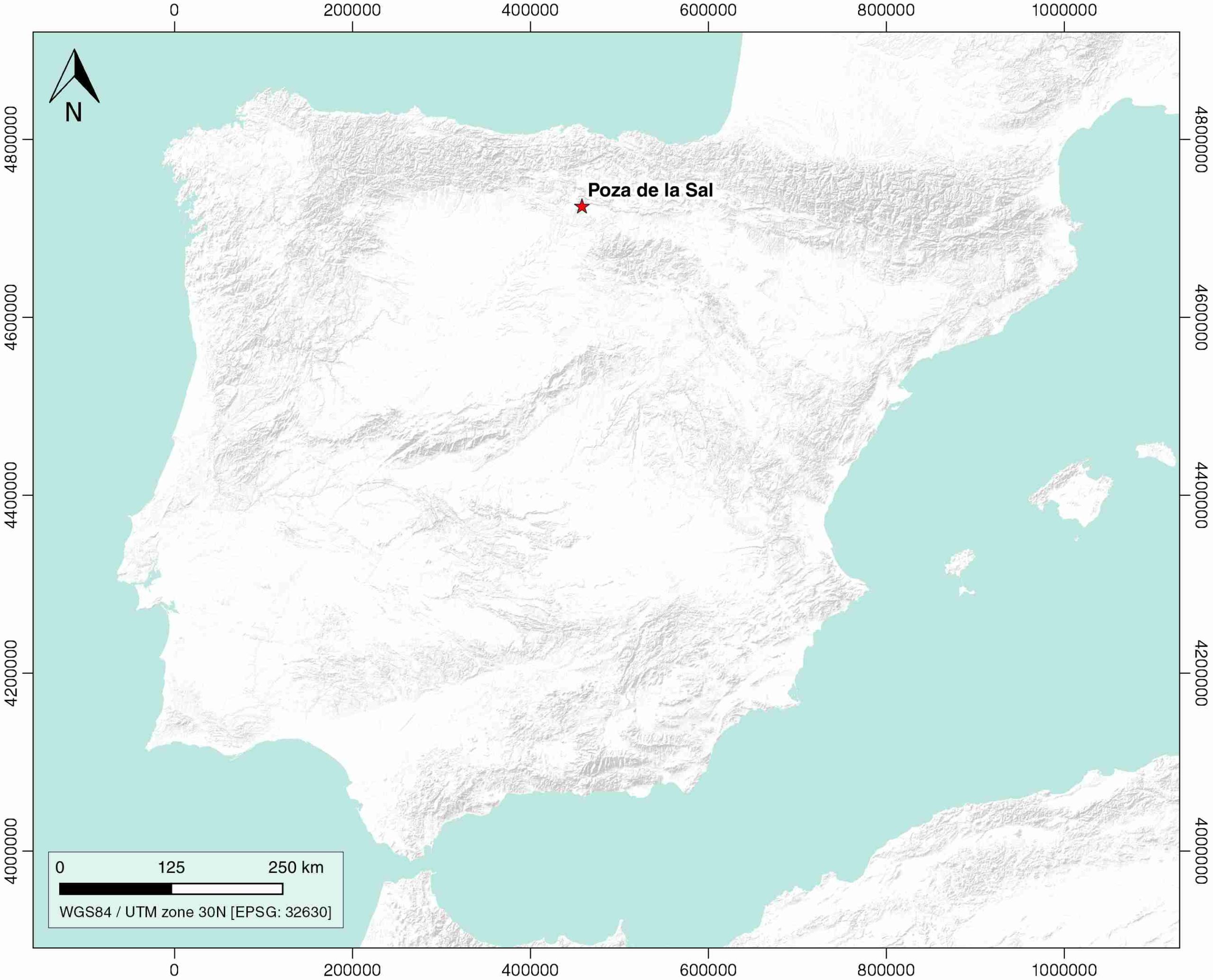
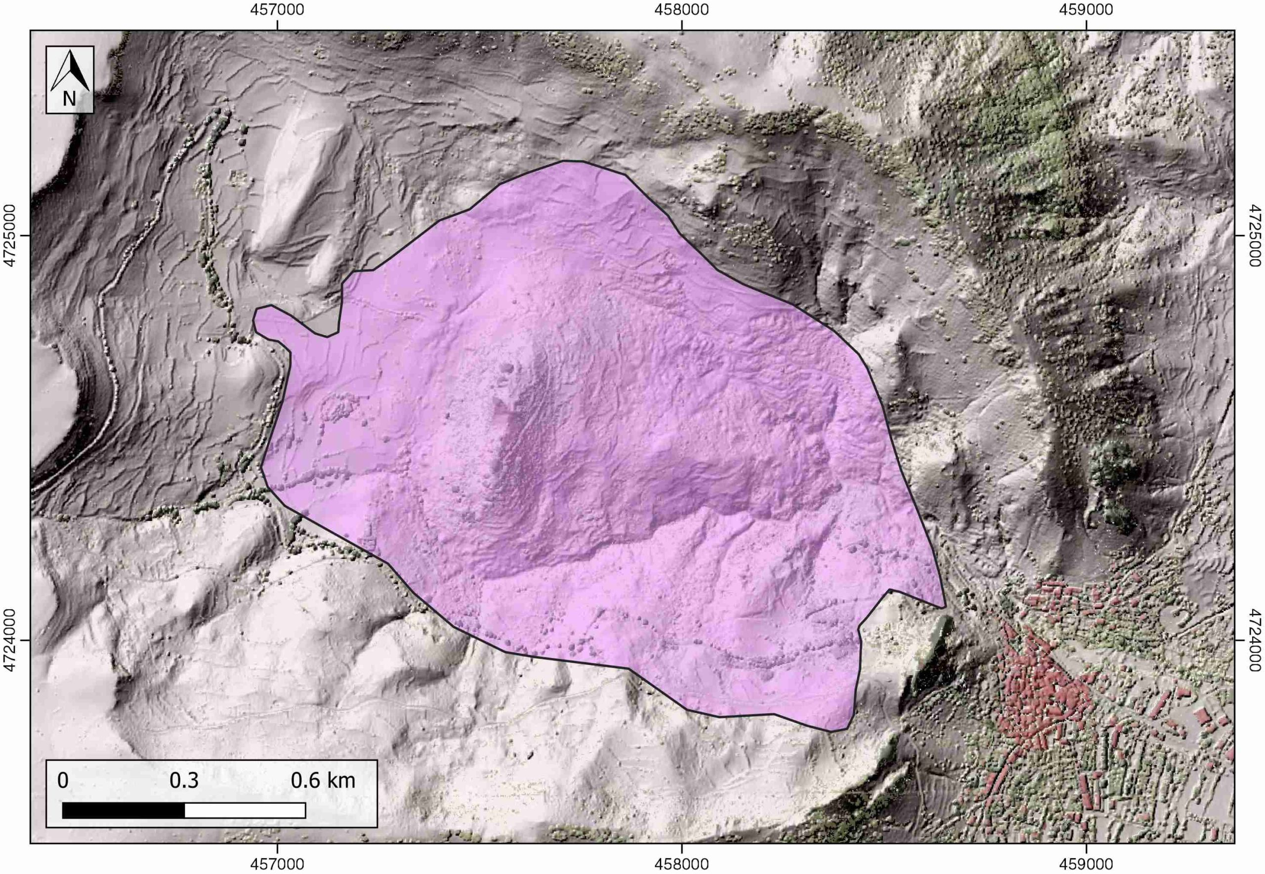
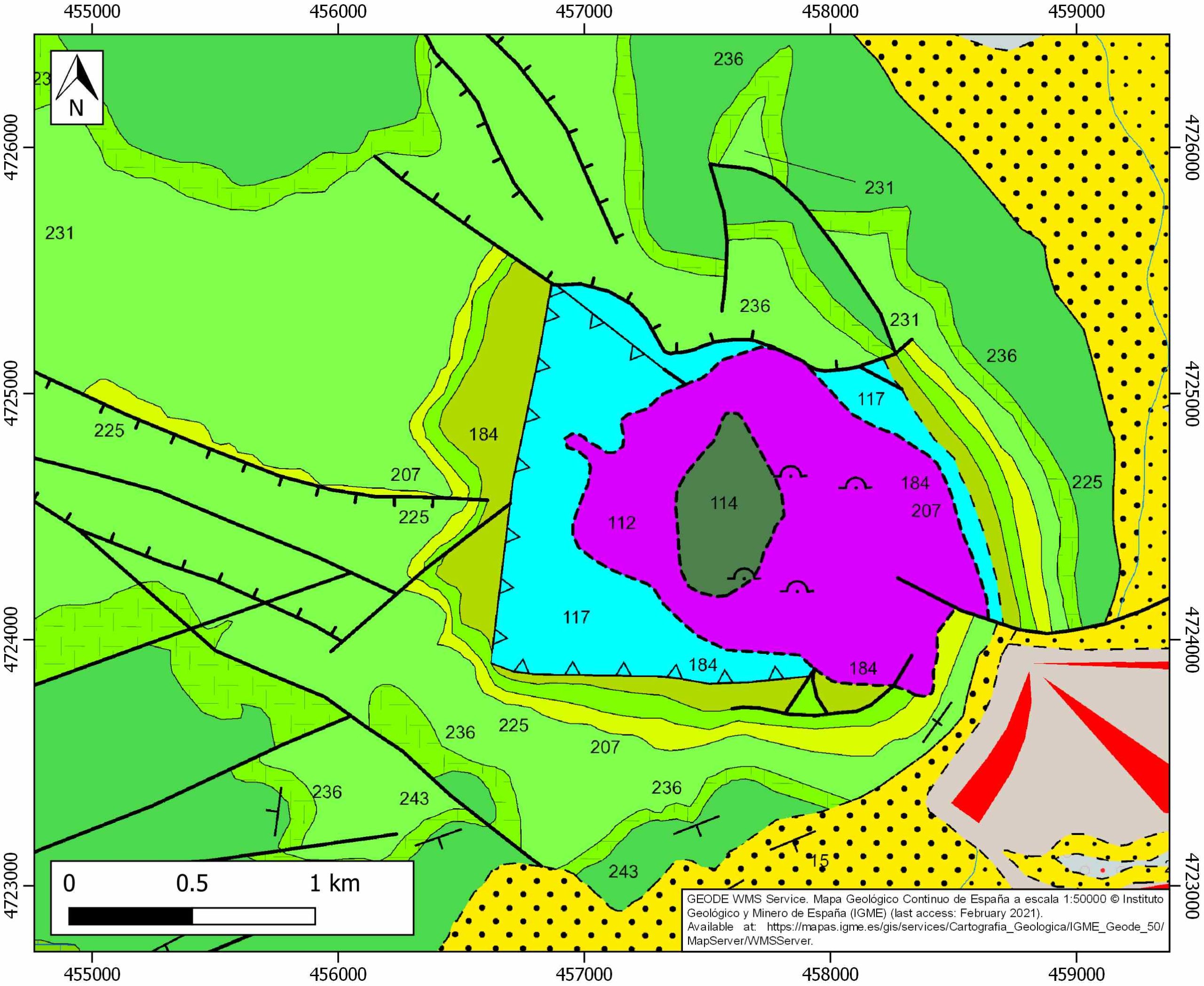
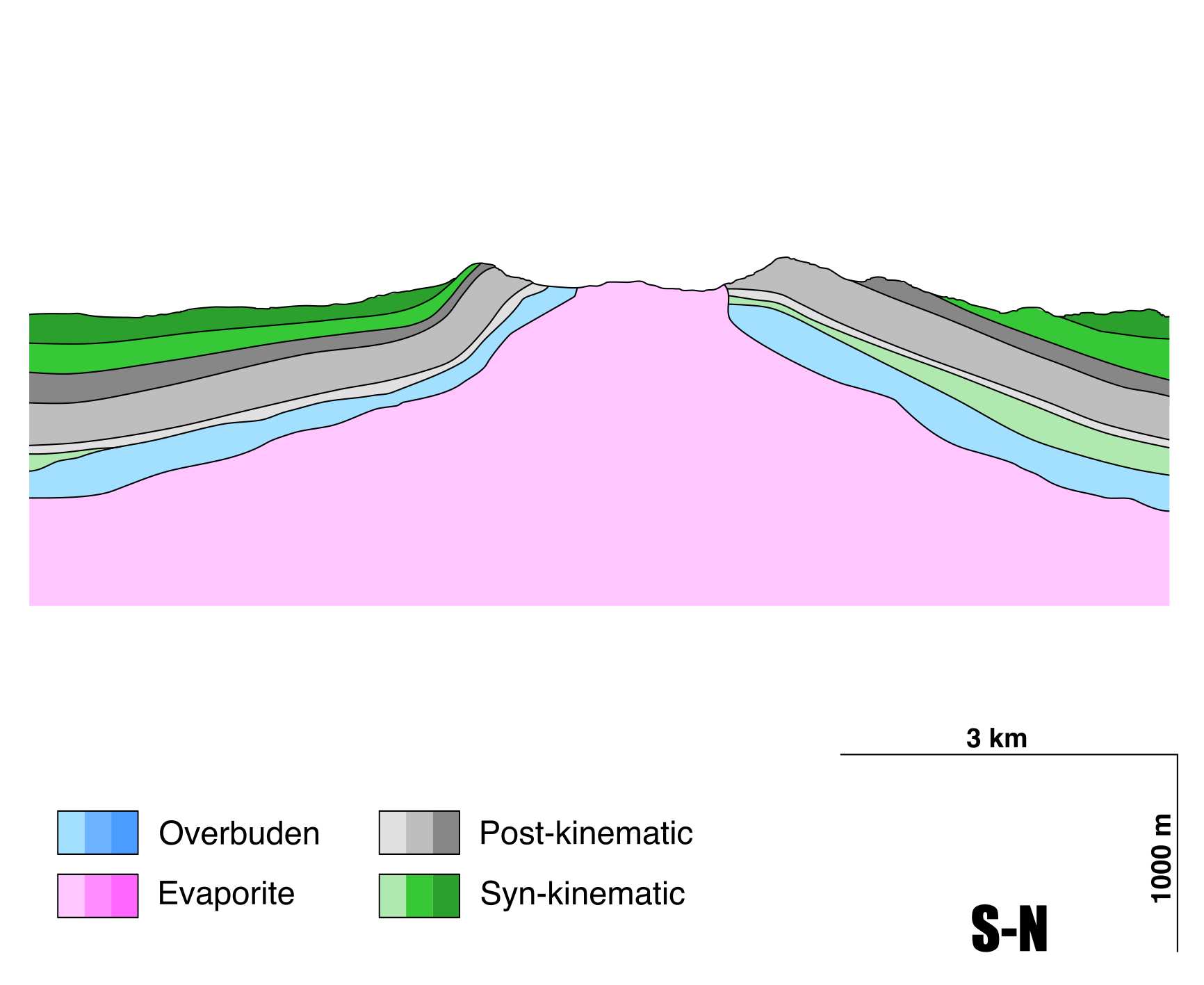
Poza de la Sal
ID #002
General Information
| Structure type | Evaporite Diapir |
| Deformed/Undeformed | Deformed |
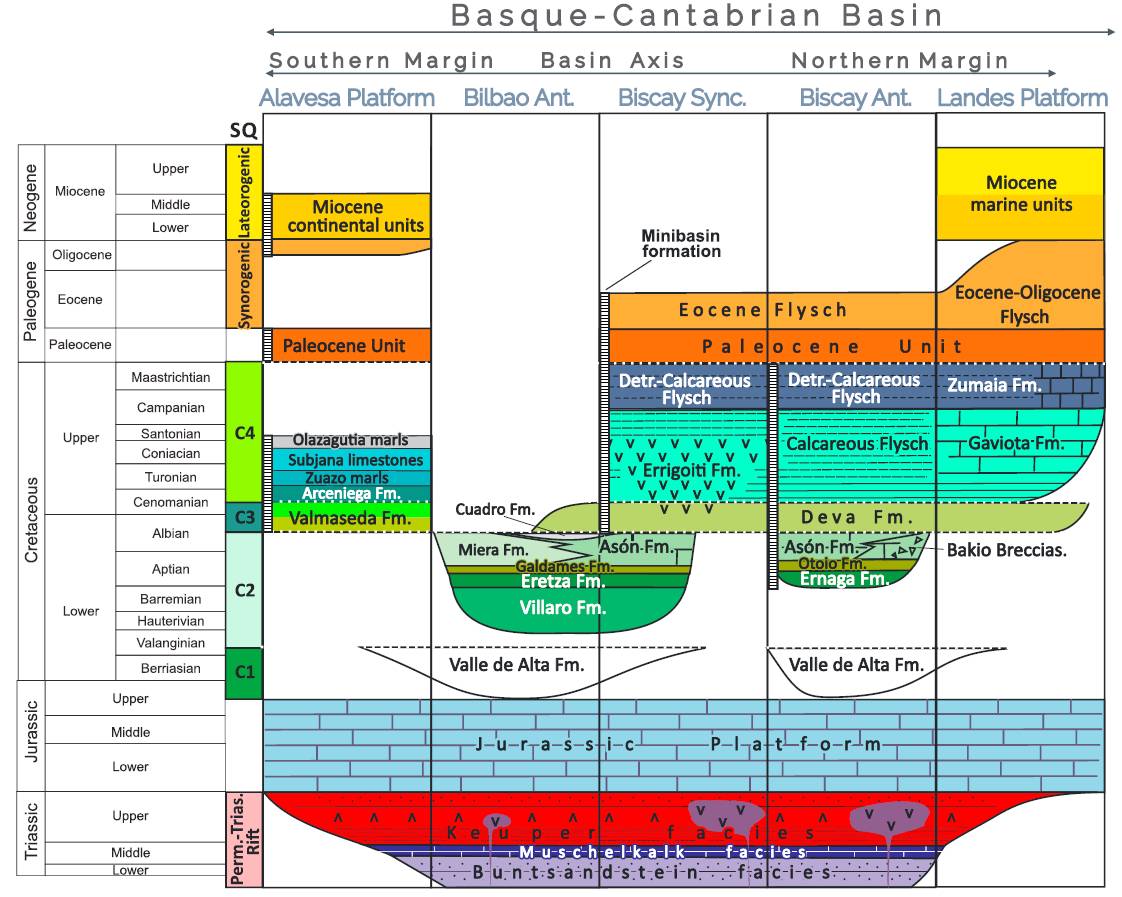
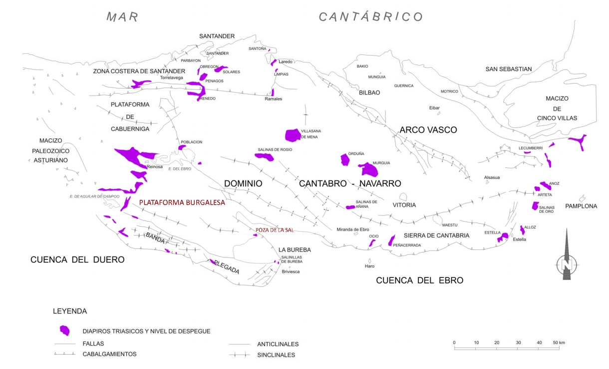
| Geological Setting | Basque-Cantabrian Basin, Burgalesa Platform |
| Outcropping/buried | Outcropping |
| Evaporite unit/s name | Keuper facies |
| Evaporite unit/s age | Carnian-Rhaetian (Upper Triassic) |
| Evaporite unit/s origin | Marine |
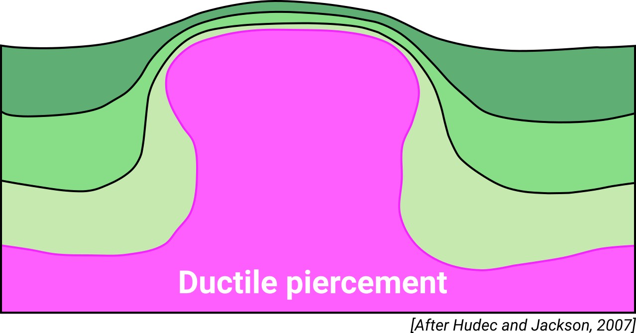
| Classif. (Hudec and Jackson, 2009) | Ductile piercement |
| Classif. (Jackson and Talbot, 1986) | Salt stock |
| Age of evaporite flow or deformation (when deformed) | Lower Cretaceous, Oligocene to Miocene |
| Other comments | Age of evaporite flow not well determined. Open-pit mine aperture suggested for 2021. |
Generic Data
| Unique ID | 02 |
| Name | Poza de la Sal |
| Structure type | Evaporite diapir |
| Deformed/Undeformed | Deformed |
| Buried/Outcropping | Outcropping |
| Geological setting | Basque-Cantabrian Basin |
| Geological Regional Setting | Burgalesa Platform |
| Evaporite unit/s name | Keuper facies |
| Evaporite unit/s age | Carnian-Rhaetian (Upper Triassic) |
| Evaporite unit/s era | Mesozoic |
| Evaporite unit/s origin | Marine |
| Evaporite unit/s composition | Marlstone-Gypsum-Claystonestone-Halite |
| Post-kinematic unit/s (or post-evaporite units when evaporites are undeformed) | Upper Cretaceous (dolostones, limestones and marlstones) ; Palaeocene (dolostones, claystones and sandstones) ; Eocene (sandstones, claystones, lacustrine limestones and conglomerates) |
| Post-kinematic unit/s age (or post-evaporite units when evaporites are undeformed) | Upper Cretaceous-Eocene |
| Classification (Hudec and Jackson, 2009) | Ductile piercement |
| Classification (Jackson and Talbot, 1986) | Salt stock |
| Mining activity? | Y |
| Mining activity start | 19th century |
| Mining activity end | 20th century |
| Mining galleries? | Y |
| Mining products | Halite, gypsum |
| Mining sub-products | |
| Evaporite flow? | Y |
| Age of evaporite flow | late Lower Cretaceous (early stage?) and Oligocene/Miocene (late reactivation stage?) |
| Flow or deformation triggering mechanisms | Mesozoic extensional regime in the Basque–Cantabrian Basin (early stage) and Alpine compression (late reactivation stage) |
| Flow-linked structures? | Y |
| Halokinetic structures | Joints / Faults / Low-angle extensional faults / Anticline folding / Progressive discordances |
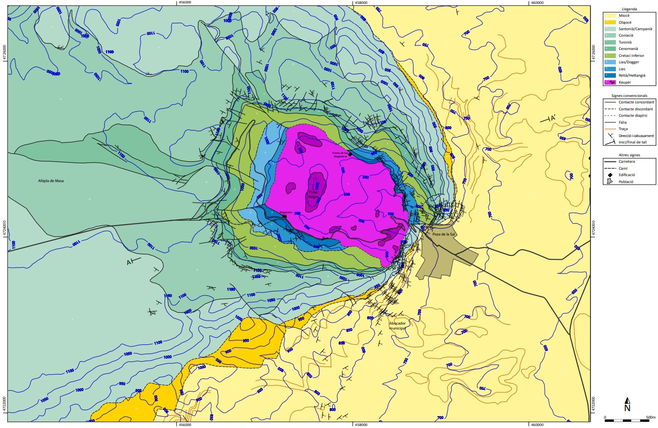
| Post-evaporite and pre-kinematic unit/s (overbuden) | Jurassic (Calcareous breccias, limestones and dolomites) |
| Syn-kinematic unit/s | Late Upper Cretaceous (limestones, marlstones, marly limestones, dolostones, micritic limestones) ; Oligocene (red claystones and sandstones) |
| Available seismic profiles | VAL-1 / VAL-2 / VAL-4 / 92PB-02 / 92PB-03 / 92PB-04 / |
| Available boreholes | |
| Additional comments | Age of evaporite flow not well determined. Open-pit mine aperture suggested for 2021 |
Mining Data
| UNIQUE_ID | 2 |
| Minning exploitations within <2km? | Y |
| Historical/Active | Historical (not indexed in the Spanish National Minning Cadastre) |
| Exploitation name #1 | n.a. |
| Exploitation ID (Spanish National Mining Cadastre) #1 | n.a. |
| Municipality #1 | n.a. |
| Province #1 | n.a. |
| Company #1 | n.a. |
| Main minning Products #1 | Halite, gypsum |
| Exploitation name #2 | |
| Exploitation ID (Spanish National Mining Cadastre) #2 | |
| Municipality #2 | |
| Province #2 | |
| Company #2 | |
| Main minning Products #2 | |
| Exploitation name #3 | |
| Exploitation ID (Spanish National Mining Cadastre) #3 | |
| Municipality #3 | |
| Province #3 | |
| Company #3 | |
| Main minning Products #3 |
Quantitative Data
| UNIQUE_ID | 2 |
| Outcropping area (km2) | 1.50265 |
| Horizontal intersection area (km2) (when buried) | Not buried |
| Depth of intersection area (km2) (when buried) | Not buried |
| Max. Width (Km) | 1.8 |
| Max. Length (Km) | 1.2 |
| Max. Evaporites thickness (km) | 0.6 |
| Max. Deformation age (Ma) | 113 |
| Min. Deformation age (Ma) | 23 |
| Deformation stages | 1 |
Reference Data
| UNIQUE_ID | 2 |
| Section source | Quintà, A., Tavani, S. and Roca, E., 2012. Fracture pattern analysis as a tool for constraining the interaction between regional and diapir-related stress fields: Poza de la Sal Diapir (Basque Pyrenees, Spain). In Alsop,G. I.,Archer, S. G.,Hartley,A. J.,Grant, N. T and Hodgkinson,R. (eds), Salt Tectonics, Sediments and Prospectivity. Geological Society, London, Special Publications, 363, 521–532. [link] |
| Well / Borehole availability #1 | Mas-Tudó, R., 2011. Geometria i cinemàtica del diapir salí de Poza de la Sal. PhD thesis, Universitat de Barcelona – Universitat Politècnica de Catalunya, Barcelona. [link] |
| Well / Borehole availability #2 | n.a. |
| Available data (Stratigraphy) #1 | Cámara, P., 2017. Salt and Strike-Slip Tectonics as Main Drivers in the Structural Evolution of the Basque-Cantabrian Basin, Spain. In Permo-Triassic Salt Provinces of Europe, North Africa and the Atlantic Margins (pp. 371-393). Elsevier. [link] |
| Available data (Stratigraphy) #2 | Martín-Chivelet, J., López-Gómez, J., Aguado, R., Arias, C., Arribas, J., Arribas, M. E., … , Casas-Sainz, A., 2019. The Late Jurassic–Early Cretaceous Rifting. In (Quesada C., Oliveira J., eds.): The Geology of Iberia: A Geodynamic Approach. Regional Geology Reviews. Springer, Cham. [link] |
| Available data (Stratigraphy) #3 | Espina, R. G., 1997. La estructura y evolución tectonoestatigráfica del borde occidental de la Cuenca Vasco-Cantábrica (Cordillera Cantábrica, NO de España) [Ph.D. thesis]: Univeridad de Oviedo: 230 p. [link] |
| Available data (Stratigraphy) #4 | Carola, E., Muñoz, J. A., Roca, E., 2015. The transition from thick-skinned to thin-skinned tectonics in the Basque-Cantabrian Pyrenees: The Burgalesa Platform and surroundings. International Journal of Earth Sciences, 104(8), 2215-2239. [link] |
| Available data (Stratigraphy) #5 | Peropadre, C., Mediato, J. F., Hernaiz, P. P., Robador, A., Solé, F. X., Sarrionandía, F., 2012. La discordancia de La Mesa (base de las Facies Utrillas) en el sinclinal de Polientes (Cretácico, Cuenca Vasco-Cantábrica): implicaciones tectónicas. Geotemas, 13, 85. [link] |
| Available data (Stratigraphy) #6 | Cámara, P., 2020. Inverted turtle salt anticlines in the eastern basque-cantabrian basin, Spain. Marine and Petroleum Geology, 104358. [link] |
| Regional Stratigraphy | Pedrera, A., García‐Senz, J., Ayala, C., Ruiz‐Constán, A., Rodríguez‐Fernández, L. R., Robador, A., González Menéndez, L., 2017. Reconstruction of the exhumed mantle across the North Iberian Margin by crustal‐scale 3‐D gravity inversion and geological cross section. Tectonics, 36, 3155-3177. [link] |
| Seismic data availability #1 | Quintà, A., Tavani, S. and Roca, E., 2012. Fracture pattern analysis as a tool for constraining the interaction between regional and diapir-related stress fields: Poza de la Sal Diapir (Basque Pyrenees, Spain). In Alsop,G. I.,Archer, S. G.,Hartley,A. J.,Grant, N. T and Hodgkinson,R. (eds), Salt Tectonics, Sediments and Prospectivity. Geological Society, London, Special Publications, 363, 521–532. [link] |
| Seismic data availability #2 | Mas-Tudó, R., 2011. Geometria i cinemàtica del diapir salí de Poza de la Sal. PhD thesis, Universitat de Barcelona – Universitat Politècnica de Catalunya, Barcelona. [link] |
| Seismic data availability #3 | n.a. |
| Available data (Structure) #1 | Quintà, A., Tavani, S. and Roca, E., 2012. Fracture pattern analysis as a tool for constraining the interaction between regional and diapir-related stress fields: Poza de la Sal Diapir (Basque Pyrenees, Spain). In Alsop,G. I.,Archer, S. G.,Hartley,A. J.,Grant, N. T and Hodgkinson,R. (eds), Salt Tectonics, Sediments and Prospectivity. Geological Society, London, Special Publications, 363, 521–532. [link] |
| Available data (Structure) #2 | Cámara, P., 2020. Inverted turtle salt anticlines in the eastern basque-cantabrian basin, Spain. Marine and Petroleum Geology, 104358. [link] |
| Available data (Structure) #3 | Cámara, P., 2017. Salt and Strike-Slip Tectonics as Main Drivers in the Structural Evolution of the Basque-Cantabrian Basin, Spain. In Permo-Triassic Salt Provinces of Europe, North Africa and the Atlantic Margins (pp. 371-393). Elsevier. [link] |
| Available data (Structure) #4 | Carola, E., Muñoz, J. A., Roca, E., 2015. The transition from thick-skinned to thin-skinned tectonics in the Basque-Cantabrian Pyrenees: The Burgalesa Platform and surroundings. International Journal of Earth Sciences, 104(8), 2215-2239. [link] |
| Available data (Structure) #5 | Pedrera, A., García‐Senz, J., Ayala, C., Ruiz‐Constán, A., Rodríguez‐Fernández, L. R., Robador, A., González Menéndez, L., 2017. Reconstruction of the exhumed mantle across the North Iberian Margin by crustal‐scale 3‐D gravity inversion and geological cross section. Tectonics, 36, 3155-3177. [link] |
| Available data (Structure) #6 | Espina, R. G., 1997. La estructura y evolución tectonoestatigráfica del borde occidental de la Cuenca Vasco-Cantábrica (Cordillera Cantábrica, NO de España) [Ph.D. thesis]: Univeridad de Oviedo: 230 p. [link] |
| Available data (Analogue modelling) #1 | n.a. |
| Available data (Analogue modelling) #2 | n.a. |
| Available data (Analogue modelling) #3 | n.a. |
| Available data (Gravimetry – Tomography) #1 | Ayala, C., Bohoyo, F., Maestro, A., Reguera, M. I., Torne, M., Rubio, F., Fernández, M., García-Lobón, J. L., 2016. Updated Bouguer anomalies of the Iberian Peninsula: a new perspective to interpret the regional geology. Journal of Maps, 12(5), 1089-1092. [link] |
| Available data (Gravimetry – Tomography) #2 | Pedrera, A., García‐Senz, J., Ayala, C., Ruiz‐Constán, A., Rodríguez‐Fernández, L. R., Robador, A., González Menéndez, L., 2017. Reconstruction of the exhumed mantle across the North Iberian Margin by crustal‐scale 3‐D gravity inversion and geological cross section. Tectonics, 36, 3155-3177. [link] |
| Available data (Gravimetry – Tomography) #3 | Nettleton, L.L., 1968. Gravity anomalies over salt diapirs, northern Spain. Geological Society of America Special Papers, 88, 75–82. [link] |
| Available data (Geochemistry) #1 | Ortí, F., García-Veigas, J., Rossell, L., Jurado, M. J., Utrilla, R., 1996. Formaciones salinas de las cuencas triásicas en la Península Ibérica: Caracterización Petrológica y Geoquímica. Cuadernos de Geología Ibérica, 20, 13-35. [link] |
| Available data (Geochemistry) #2 | Andrés, J., Alcalde, J., Ayarza, P., Saura, E., Marzán, I., Martí, D., … & Rubio, F. M., 2016. Basement structure of the Hontomín CO2 storage site (Spain) determined by integration of microgravity and 3D seismic data. Solid earth, 7, 827-841. [link] |
| Available data (Geochemistry) #3 | n.a. |
| Available data (Geochemistry) #4 | n.a. |
| Available data (Petrophysics) #1 | Llamas, B., Castañeda, M. C., Laín, C., Pous, J., 2017. Study of the Basque–Cantabrian basin as a suitable region for the implementation of an energy storage system based on compressed air energy storage (CAES). Environmental Earth Sciences, 76(5), 204. [link] |
| Available data (Petrophysics) #2 | n.a. |
| IGME Geological Map (MAGNA50) Sheet number | 136-Oña. [link] |
| Other Maps #1 (source) | Mas-Tudó, R., 2011. Geometria i cinemàtica del diapir salí de Poza de la Sal [PhD thesis]: Universitat de Barcelona – Universitat Politècnica de Catalunya, 77pp. [link] |
| Other Maps #2 (source) | Mas-Tudó, R., 2011. Geometria i cinemàtica del diapir salí de Poza de la Sal. PhD thesis, Universitat de Barcelona – Universitat Politècnica de Catalunya, Barcelona. [link] |
| Other related references #1 | n.a. |
| Other related references #2 | n.a. |
| Other related references #3 | n.a. |
| Other related references #4 | n.a. |
Well and Seismic Data
| UNIQUE_ID | 2 |
| Seismic survey name #1 | 7C3-VAL |
| Across structure? #1 | N (within 3km) |
| Seismic profile ID (IGME) #1 | 9604 |
| Seismic profile code #1 | 14177 |
| Seismic profile name #1 | VAL-2 |
| Seismic survey year #1 | 1981 |
| Data repository #1 | SIGEOF Data Catalogue (Section available under request). ©Instituto Geológico y Minero de España (IGME). https://info.igme.es/SIGEOF/ |
| Length (km) #1 | 31.70 |
| Seismic survey name #2 | 7C-ST-75 |
| Across structure? #2 | N (within 3km) |
| Seismic profile ID (IGME) #2 | 12596 |
| Seismic profile code #2 | 17314 |
| Seismic profile name #2 | U-5 |
| Seismic survey year #2 | 1964 |
| Data repository #2 | SIGEOF Data Catalogue (Private access section). ©Instituto Geológico y Minero de España (IGME). https://info.igme.es/SIGEOF/ |
| Length (km) #2 | 11.44 |
| Seismic survey name #3 | 7C-ST-75 |
| Across structure? #3 | N (within 3km) |
| Seismic profile ID (IGME) #3 | 12620 |
| Seismic profile code #3 | 17338 |
| Seismic profile name #3 | U-24 |
| Seismic survey year #3 | 1964 |
| Data repository #3 | SIGEOF Data Catalogue (Private access section). ©Instituto Geológico y Minero de España (IGME). https://info.igme.es/SIGEOF/ |
| Length (km) #3 | 17.63 |
| Seismic survey name #4 | 7C3-VAL |
| Across structure? #4 | N (within 3km) |
| Seismic profile ID (IGME) #4 | 9605 |
| Seismic profile code #4 | 14178 |
| Seismic profile name #4 | VAL-1 |
| Seismic survey year #4 | 1981 |
| Data repository #4 | SIGEOF Data Catalogue (Private access section). ©Instituto Geológico y Minero de España (IGME). https://info.igme.es/SIGEOF/ |
| Length (km) #4 | 18.11 |
| Seismic survey name #5 | 7C-ST-59 |
| Across structure? #5 | N (within 3km) |
| Seismic profile ID (IGME) #5 | 12722 |
| Seismic profile code #5 | 17440 |
| Seismic profile name #5 | BUR-3 |
| Seismic survey year #5 | 1967 |
| Data repository #5 | SIGEOF Data Catalogue (Private access section). ©Instituto Geológico y Minero de España (IGME). https://info.igme.es/SIGEOF/ |
| Length (km) #5 | 7.45 |
| Seismic survey name #6 | 7C-ST-75 |
| Across structure? #6 | N (within 3km) |
| Seismic profile ID (IGME) #6 | 12601 |
| Seismic profile code #6 | 17319 |
| Seismic profile name #6 | U-44 |
| Seismic survey year #6 | 1964 |
| Data repository #6 | SIGEOF Data Catalogue (Private access section). ©Instituto Geológico y Minero de España (IGME). https://info.igme.es/SIGEOF/ |
| Length (km) #6 | 6.35 |
| Seismic survey name #7 | 7C2-BG |
| Across structure? #7 | N (within 3km) |
| Seismic profile ID (IGME) #7 | 9475 |
| Seismic profile code #7 | 14048 |
| Seismic profile name #7 | BG-37 |
| Seismic survey year #7 | 1975 |
| Data repository #7 | SIGEOF Data Catalogue (Private access section). ©Instituto Geológico y Minero de España (IGME). https://info.igme.es/SIGEOF/ |
| Length (km) #7 | 17.82 |
| Seismic survey name #8 | 7C-ST-75 |
| Across structure? #8 | N (within 3km) |
| Seismic profile ID (IGME) #8 | 12598 |
| Seismic profile code #8 | 17316 |
| Seismic profile name #8 | U-48 |
| Seismic survey year #8 | 1964 |
| Data repository #8 | SIGEOF Data Catalogue (Private access section). ©Instituto Geológico y Minero de España (IGME). https://info.igme.es/SIGEOF/ |
| Length (km) #8 | 4.91 |
| Seismic survey name #9 | |
| Across structure? #9 | |
| Seismic profile ID (IGME) #9 | |
| Seismic profile code #9 | |
| Seismic profile name #9 | |
| Seismic survey year #9 | |
| Data repository #9 | |
| Length (km) #9 | |
| Seismic survey name #10 | |
| Across structure? #10 | |
| Seismic profile ID (IGME) #10 | |
| Seismic profile code #10 | |
| Seismic profile name #10 | |
| Seismic survey year #10 | |
| Data repository #10 | |
| Length (km) #10 | |
| Seismic survey name #11 | |
| Across structure? #11 | |
| Seismic profile ID (IGME) #11 | |
| Seismic profile code #11 | |
| Seismic profile name #11 | |
| Seismic survey year #11 | |
| Data repository #11 | |
| Length (km) #11 | |
| Seismic survey name #12 | |
| Across structure? #12 | |
| Seismic profile ID (IGME) #12 | |
| Seismic profile code #12 | |
| Seismic profile name #12 | |
| Seismic survey year #12 | |
| Data repository #12 | |
| Length (km) #12 | |
| Seismic survey name #13 | |
| Across structure? #13 | |
| Seismic profile ID (IGME) #13 | |
| Seismic profile code #13 | |
| Seismic profile name #13 | |
| Seismic survey year #13 | |
| Data repository #13 | |
| Length (km) #13 | |
| Seismic survey name #14 | |
| Across structure? #14 | |
| Seismic profile ID (IGME) #14 | |
| Seismic profile code #14 | |
| Seismic profile name #14 | |
| Seismic survey year #14 | |
| Data repository #14 | |
| Length (km) #14 | |
| Seismic survey name #15 | |
| Across structure? #15 | |
| Seismic profile ID (IGME) #15 | |
| Seismic profile code #15 | |
| Seismic profile name #15 | |
| Seismic survey year #15 | |
| Data repository #15 | |
| Length (km) #15 | |
| Seismic survey name #16 | |
| Across structure? #16 | |
| Seismic profile ID (IGME) #16 | |
| Seismic profile code #16 | |
| Seismic profile name #16 | |
| Seismic survey year #16 | |
| Data repository #16 | |
| Length (km) #16 | |
| Seismic survey name #17 | |
| Across structure? #17 | |
| Seismic profile ID (IGME) #17 | |
| Seismic profile code #17 | |
| Seismic profile name #17 | |
| Seismic survey year #17 | |
| Data repository #17 | |
| Length (km) #17 | |
| Seismic survey name #18 | |
| Across structure? #18 | |
| Seismic profile ID (IGME) #18 | |
| Seismic profile code #18 | |
| Seismic profile name #18 | |
| Seismic survey year #18 | |
| Data repository #18 | |
| Length (km) #18 | |
| Seismic survey name #19 | |
| Across structure? #19 | |
| Seismic profile ID (IGME) #19 | |
| Seismic profile code #19 | |
| Seismic profile name #19 | |
| Seismic survey year #19 | |
| Data repository #19 | |
| Length (km) #19 | |
| Seismic survey name #20 | |
| Across structure? #20 | |
| Seismic profile ID (IGME) #20 | |
| Seismic profile code #20 | |
| Seismic profile name #20 | |
| Seismic survey year #20 | |
| Data repository #20 | |
| Length (km) #20 | |
| Seismic survey name #21 | |
| Across structure? #21 | |
| Seismic profile ID (IGME) #21 | |
| Seismic profile code #21 | |
| Seismic profile name #21 | |
| Seismic survey year #21 | |
| Data repository #21 | |
| Length (km) #21 | |
| Borehole name #1 | |
| Company #1 | |
| Traget #1 | |
| Across structure? #1 | |
| Borehole name #2 | |
| Company #2 | |
| Traget #2 | |
| Across structure? #2 | |
| Borehole name #3 | |
| Company #3 | |
| Traget #3 | |
| Across structure? #3 | |
| Borehole name #4 | |
| Company #4 | |
| Traget #4 | |
| Across structure? #4 | |
| Borehole name #5 | |
| Company #5 | |
| Traget #5 | |
| Across structure? #5 | |
| Borehole name #6 | |
| Company #6 | |
| Traget #6 | |
| Across structure? #6 | |
| Borehole name #7 | |
| Company #7 | |
| Traget #7 | |
| Across structure? #7 | |
| Borehole name #8 | |
| Company #8 | |
| Traget #8 | |
| Across structure? #8 | |
| Borehole name #9 | |
| Company #9 | |
| Traget #9 | |
| Across structure? #9 | |
| Borehole name #10 | |
| Company #10 | |
| Traget #10 | |
| Across structure? #10 | |
| Borehole name #11 | |
| Company #11 | |
| Traget #11 | |
| Across structure? #11 | |
| Borehole name #12 | |
| Company #12 | |
| Traget #12 | |
| Across structure? #12 | |
| Borehole name #13 | |
| Company #13 | |
| Traget #13 | |
| Across structure? #13 | |
| Borehole name #14 | |
| Company #14 | |
| Traget #14 | |
| Across structure? #14 | |
| Borehole name #15 | |
| Company #15 | |
| Traget #15 | |
| Across structure? #15 |
Geographical Data (EPSG:4326 - WGS 84)
| UNIQUE_ID | 2 |
| X Centroid (Structure shape) | -3.514857 |
| Y Centroid (Structure shape) | -3.514857 |
| Xmin (Structure shape) | -3.525530 |
| Xmax (Structure shape) | -3.504567 |
| Ymin (Structure shape) | 42.665301 |
| Ymax (Structure shape) | 42.677976 |
| Xmin seismic line #1 | -3.574504 |
| Xmax seismic line #1 | -3.487600 |
| Ymin seismic line #1 | 42.634813 |
| Ymax seismic line #1 | 42.911169 |
| Xmin seismic line #2 | -3.651260 |
| Xmax seismic line #2 | -3.537890 |
| Ymin seismic line #2 | 42.660468 |
| Ymax seismic line #2 | 42.719218 |
| Xmin seismic line #3 | -3.630904 |
| Xmax seismic line #3 | -3.483187 |
| Ymin seismic line #3 | 42.616773 |
| Ymax seismic line #3 | 42.663666 |
| Xmin seismic line #4 | -3.650910 |
| Xmax seismic line #4 | -3.459139 |
| Ymin seismic line #4 | 42.660477 |
| Ymax seismic line #4 | 42.734800 |
| Xmin seismic line #5 | -3.572318 |
| Xmax seismic line #5 | -3.492502 |
| Ymin seismic line #5 | 42.618422 |
| Ymax seismic line #5 | 42.638961 |
| Xmin seismic line #6 | -3.624279 |
| Xmax seismic line #6 | -3.551173 |
| Ymin seismic line #6 | 42.649511 |
| Ymax seismic line #6 | 42.666862 |
| Xmin seismic line #7 | -3.479581 |
| Xmax seismic line #7 | -3.334713 |
| Ymin seismic line #7 | 42.554460 |
| Ymax seismic line #7 | 42.673677 |
| Xmin seismic line #8 | -3.593689 |
| Xmax seismic line #8 | -3.541360 |
| Ymin seismic line #8 | 42.642469 |
| Ymax seismic line #8 | 42.661055 |
| Xmin seismic line #9 | |
| Xmax seismic line #9 | |
| Ymin seismic line #9 | |
| Ymax seismic line #9 | |
| Xmin seismic line #10 | |
| Xmax seismic line #10 | |
| Ymin seismic line #10 | |
| Ymax seismic line #10 | |
| Xmin seismic line #11 | |
| Xmax seismic line #11 | |
| Ymin seismic line #11 | |
| Ymax seismic line #11 | |
| Xmin seismic line #12 | |
| Xmax seismic line #12 | |
| Ymin seismic line #12 | |
| Ymax seismic line #12 | |
| Xmin seismic line #13 | |
| Xmax seismic line #13 | |
| Ymin seismic line #13 | |
| Ymax seismic line #13 | |
| Xmin seismic line #14 | |
| Xmax seismic line #14 | |
| Ymin seismic line #14 | |
| Ymax seismic line #14 | |
| Xmin seismic line #15 | |
| Xmax seismic line #15 | |
| Ymin seismic line #15 | |
| Ymax seismic line #15 | |
| Xmin seismic line #16 | |
| Xmax seismic line #16 | |
| Ymin seismic line #16 | |
| Ymax seismic line #16 | |
| Xmin seismic line #17 | |
| Xmax seismic line #17 | |
| Ymin seismic line #17 | |
| Ymax seismic line #17 | |
| Xmin seismic line #18 | |
| Xmax seismic line #18 | |
| Ymin seismic line #18 | |
| Ymax seismic line #18 | |
| Xmin seismic line #19 | |
| Xmax seismic line #19 | |
| Ymin seismic line #19 | |
| Ymax seismic line #19 | |
| Xmin seismic line #20 | |
| Xmax seismic line #20 | |
| Ymin seismic line #20 | |
| Ymax seismic line #20 | |
| Xmin seismic line #21 | |
| Xmax seismic line #21 | |
| Ymin seismic line #21 | |
| Ymax seismic line #21 | |
| X borehole #1 | |
| Y borehole #1 | |
| X borehole #2 | |
| Y borehole #2 | |
| X borehole #3 | |
| Y borehole #3 | |
| X borehole #4 | |
| Y borehole #4 | |
| X borehole #5 | |
| Y borehole #5 | |
| X borehole #6 | |
| Y borehole #6 | |
| X borehole #7 | |
| Y borehole #7 | |
| X borehole #8 | |
| Y borehole #8 | |
| X borehole #9 | |
| Y borehole #9 | |
| X borehole #10 | |
| Y borehole #10 | |
| X borehole #11 | |
| Y borehole #11 | |
| X borehole #12 | |
| Y borehole #12 | |
| X borehole #13 | |
| Y borehole #13 | |
| X borehole #14 | |
| Y borehole #14 | |
| X borehole #15 | |
| Y borehole #15 |

