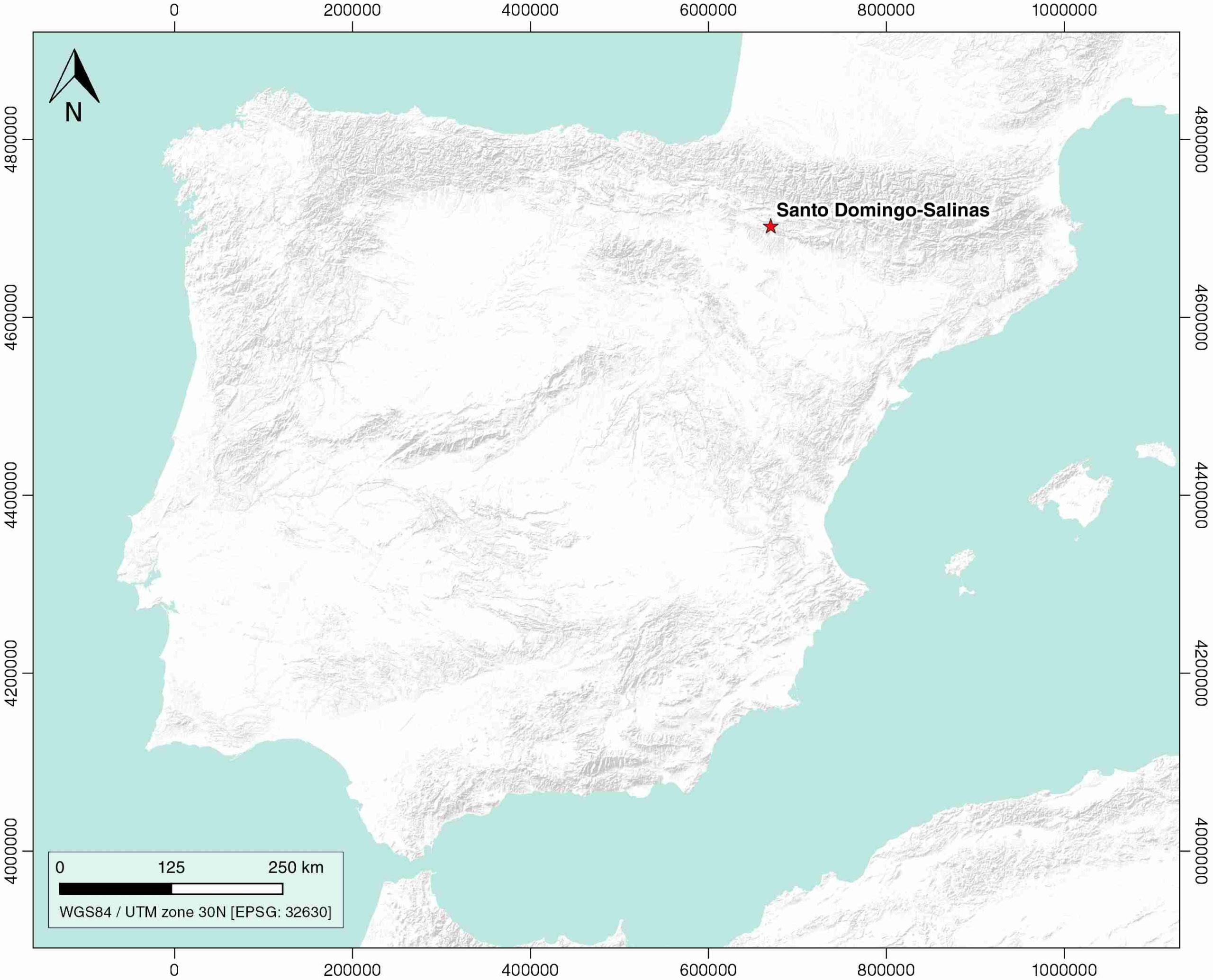
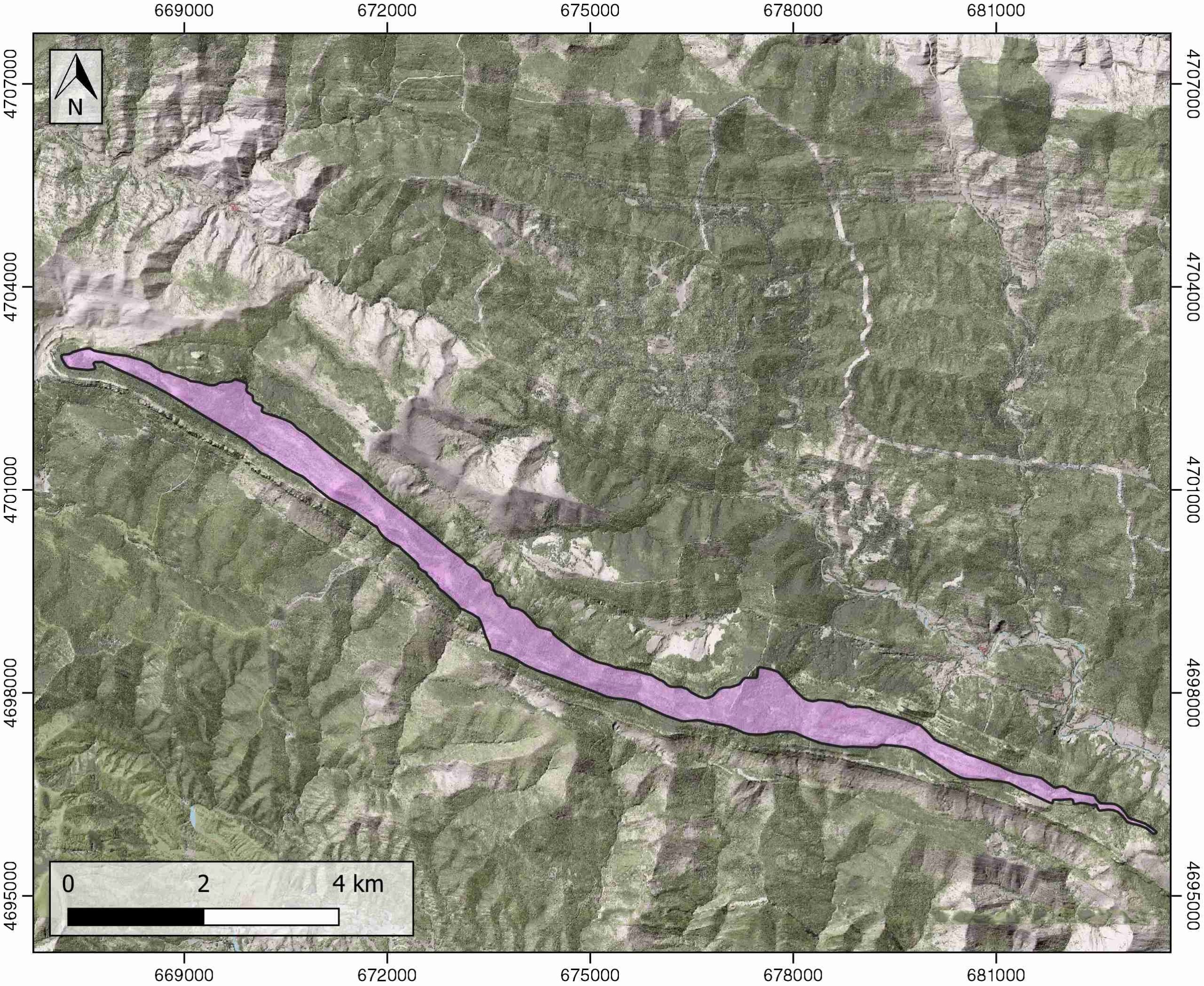
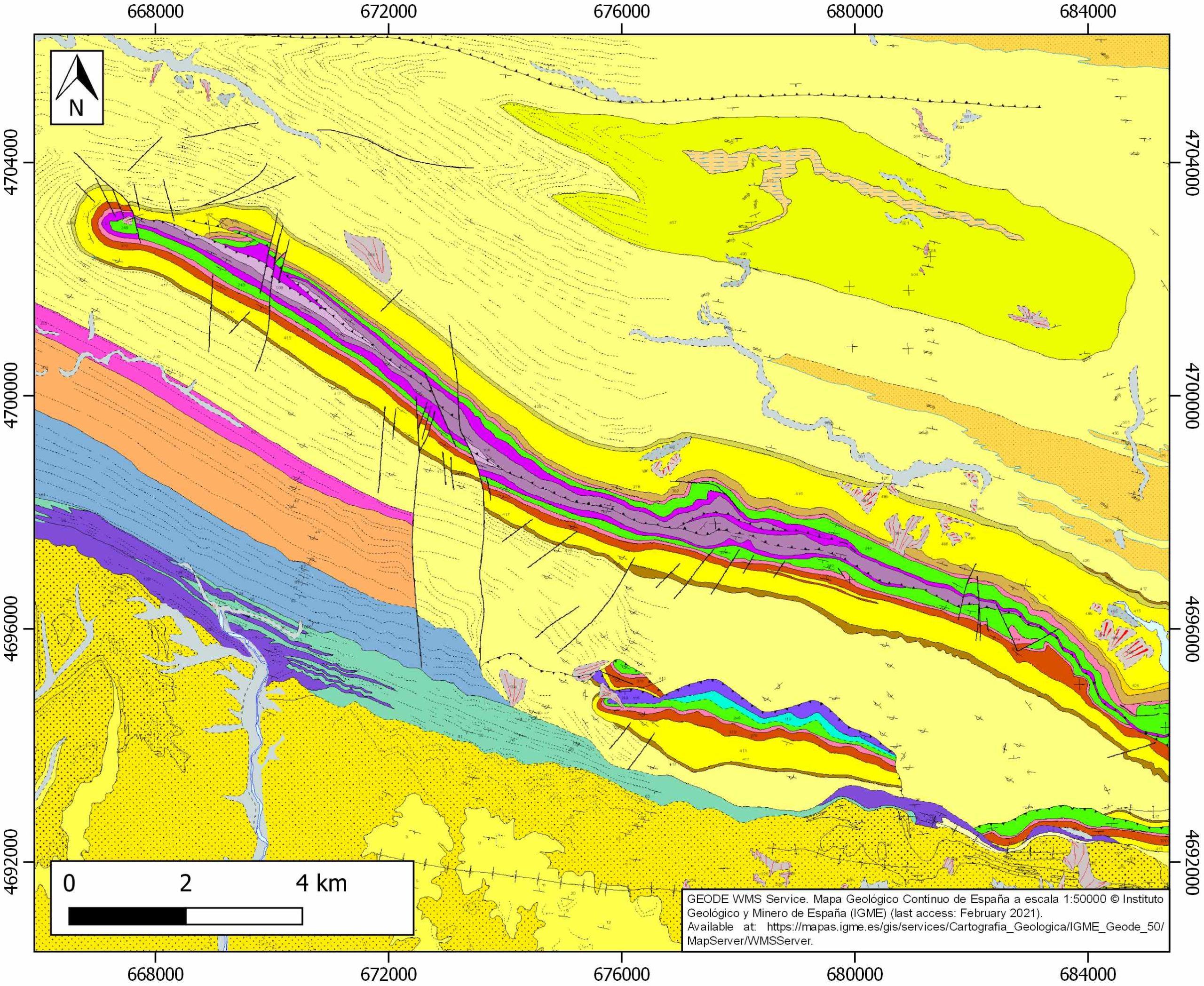
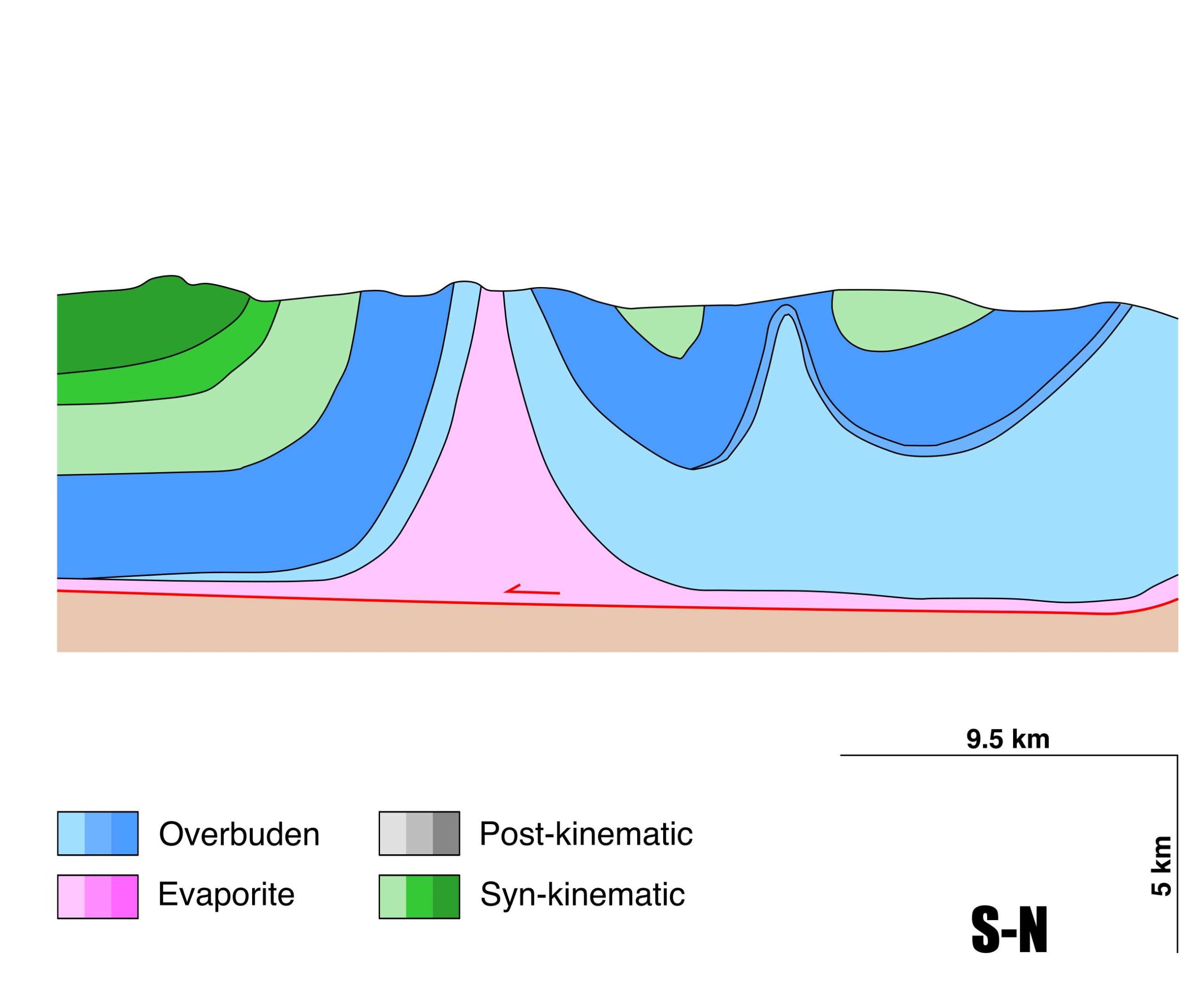
Santo Domingo-Salinas
ID #063
General Information
| Structure type | Evaporite-cored anticline |
| Deformed/Undeformed | Deformed |
| Geological Setting | External Ranges, Southern Pyrenees |
| Outcropping/buried | Outcropping |
| Evaporite unit/s name | El Pont de Suert Fm. |
| Evaporite unit/s age | Upper Anisian and Carnian-Rhaetian (Middle-Upper Triassic) |
| Evaporite unit/s origin | Marine |
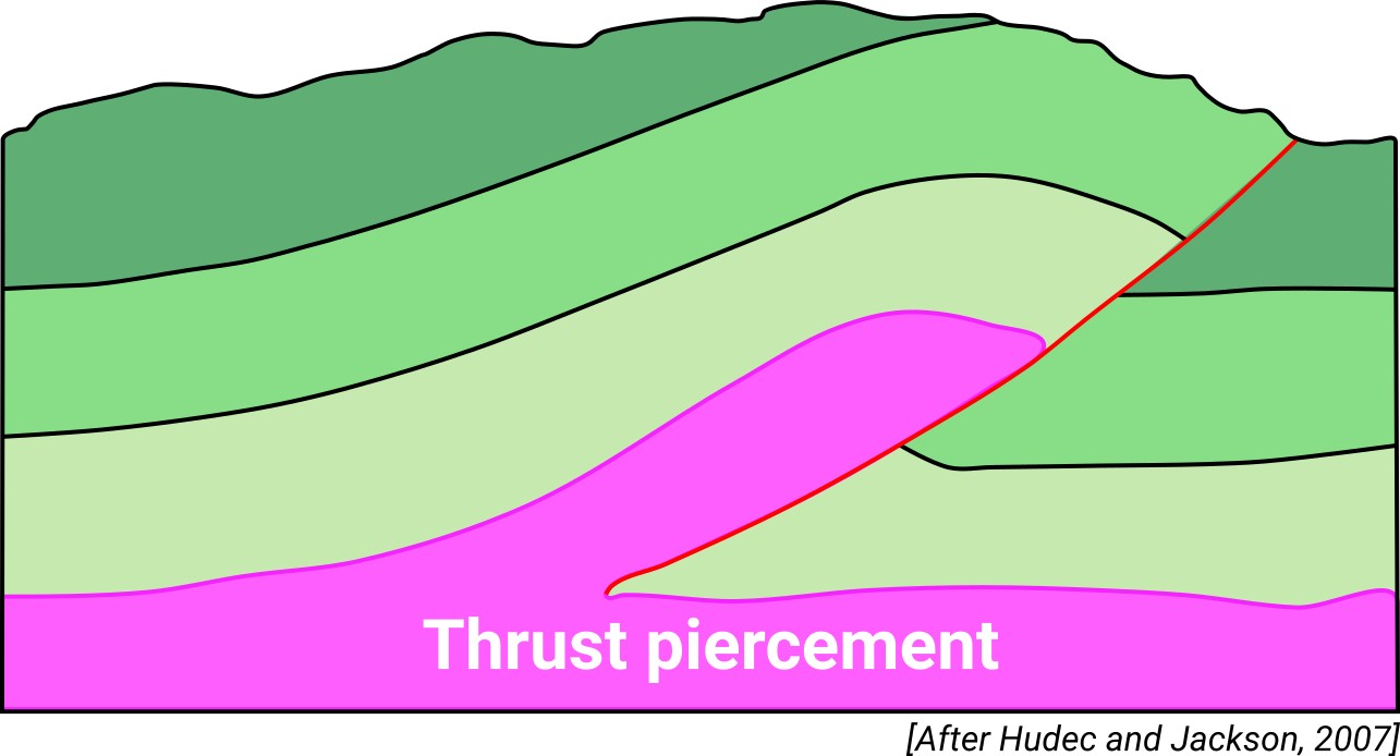
| Classif. (Hudec and Jackson, 2009) | Thrust piercement |
| Classif. (Jackson and Talbot, 1986) | Salt anticline |
| Age of evaporite flow or deformation (when deformed) | Oligocene to Miocene |
| Other comments | Syntectonic sedimentation along the southern flank of the fold (see Puigdefàbregas, 1975). Several interpretations on its depth geometry and related kinematic evolution due to the lack of seismic lines (see a review in Calvín et al., 2018). |
Generic Data
| Unique ID | 63 |
| Name | Santo Domingo-Salinas |
| Structure type | Evaporite-cored anticline |
| Deformed/Undeformed | Deformed |
| Buried/Outcropping | Outcropping |
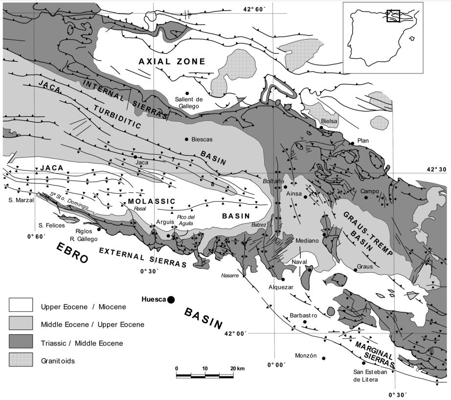
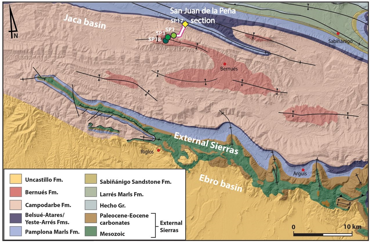
| Geological setting | Southern Pyrenees |
| Geological Regional Setting | External Ranges |
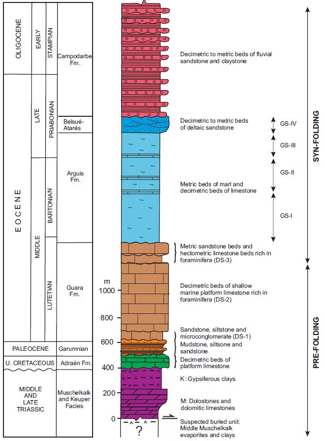
| Evaporite unit/s name | El Pont de Suert Fm. (Middle Muschelkalk and Keuper Facies) |
| Evaporite unit/s age | Upper Anisian and Carnian-Rhaetian (Middle-Upper Triassic) |
| Evaporite unit/s era | Mesozoic |
| Evaporite unit/s origin | Marine |
| Evaporite unit/s composition | Shale-Marlstone-Gypsum-Anhydrite |
| Post-kinematic unit/s (or post-evaporite units when evaporites are undeformed) | Quaternary (alluvial and colluvial detrital deposits) |
| Post-kinematic unit/s age (or post-evaporite units when evaporites are undeformed) | Pleistocene-Holocene |
| Classification (Hudec and Jackson, 2009) | Thrust piercement |
| Classification (Jackson and Talbot, 1986) | Salt anticline |
| Mining activity? | N |
| Mining activity start | |
| Mining activity end | |
| Mining galleries? | |
| Mining products | |
| Mining sub-products | |
| Evaporite flow? | Y |
| Age of evaporite flow | Late Oligocene-Early Miocene |
| Flow or deformation triggering mechanisms | External Sierras second development stage |
| Flow-linked structures? | Y |
| Halokinetic structures | Thrust faults / thickness variations / joints |
| Post-evaporite and pre-kinematic unit/s (overbuden) | Upper Cretaceous (Adraen-Bona Fms., limestones) ; Cretaceous-Palaeocene (Garumnian, Tremp Fm., sandstones, mudstones) ; Lutetian (Guara Fm., limestones rich in foraminifera) ; Bartonian-Early Priabonian (Arguís Fm., marly siltstones and sandstones) ; Late Eocene (Yeste-Arrés Fm., sandstones, conglomerates) ; Upper Priabonian-Lower Oligocene (Lower member, conglomerates and sandstones) ; Lower Oligocene-Early Upper Oligocene (Campodarbe Fm., sandstones and claystones) |
| Syn-kinematic unit/s | Upper Oligocene (Upper sequence, sandstones and claystones) ; Lower Miocene (Bernués and Uncastillo Fms., conglomerates and sandstones) |
| Available seismic profiles | |
| Available boreholes | Roncal |
| Additional comments | Syntectonic sedimentation along the southern flank of the fold (see Puigdefàbregas, 1975). Several interpretations on its depth geometry and related kinematic evolution due to the lack of seismic lines (see a review in Calvín et al., 2018). |
Mining Data
| UNIQUE_ID | 63 |
| Minning exploitations within <2km? | N |
| Historical/Active | |
| Exploitation name #1 | |
| Exploitation ID (Spanish National Mining Cadastre) #1 | |
| Municipality #1 | |
| Province #1 | |
| Company #1 | |
| Main minning Products #1 | |
| Exploitation name #2 | |
| Exploitation ID (Spanish National Mining Cadastre) #2 | |
| Municipality #2 | |
| Province #2 | |
| Company #2 | |
| Main minning Products #2 | |
| Exploitation name #3 | |
| Exploitation ID (Spanish National Mining Cadastre) #3 | |
| Municipality #3 | |
| Province #3 | |
| Company #3 | |
| Main minning Products #3 |
Quantitative Data
| UNIQUE_ID | 63 |
| Outcropping area (km2) | 7.89918 |
| Horizontal intersection area (km2) (when buried) | Not buried |
| Depth of intersection area (km2) (when buried) | Not buried |
| Max. Width (Km) | 1.97817308 |
| Max. Length (Km) | 17.6463314 |
| Max. Evaporites thickness (km) | 5 |
| Max. Deformation age (Ma) | 26 |
| Min. Deformation age (Ma) | 16 |
| Deformation stages | 1 |
Reference Data
| UNIQUE_ID | 63 |
| Section source | Calvín, P., Santolaria, P., Casas, A. M., Pueyo, E. L., 2018. Detachment fold vs. ramp anticline: a gravity survey in the southern Pyrenean front (External Sierras). Geological Journal, 53(1), 178-190. [link] |
| Well / Borehole availability #1 | Oliván, C., Pueyo, E. L., Garrido-Schneider, E., Azcón, A., Sánchez-Moreno, E., Larrasoaña, J. C., Compaired, F., 2020. Physical and chemical properties of the groundwater of the Santo Domingo-Salinas ranges, South Central Pyrenees. Journal of Maps, 16(2), 285-298. [link] |
| Well / Borehole availability #2 | n.a. |
| Available data (Stratigraphy) #1 | Silva-Casal, R., Aurell, M., Payros, A., Pueyo, E. L., Serra-Kiel, J., 2019. Carbonate ramp drowning caused by flexural subsidence: The South Pyrenean middle Eocene foreland basin. Sedimentary Geology, 393, 105538. [link] |
| Available data (Stratigraphy) #2 | Silva-Casal, R., 2017. Las plataformas carbonatadas del Eoceno medio de la Cuenca de Jaca-Pamplona (Formación Guara, Sierras Exteriores): análisis estratigráfico integral y evolución sedimentaria [Ph.D. thesis]: Universidad de Zaragoza. [link] |
| Available data (Stratigraphy) #3 | Teixell, A., 1996. The Ansó transect of the southern Pyrenees: basement and cover thrust geometries. Journal of the Geological Society, 153(2), 301-310. [link] |
| Available data (Stratigraphy) #4 | Nichols, G. J., 1987. The structure and stratigraphy of the western external sierras of the Pyrenees, northern Spain. Geological Journal, 22(3), 245-259. [link] |
| Available data (Stratigraphy) #5 | Puigdefábregas, C., 1975. La sedimentación molásica en la cuenca de Jaca. Monografías del Instituto de Estudios Pirenaicos. Número Extraordinario de la Revista Pirineos, 104, 153pp. [link] |
| Available data (Stratigraphy) #6 | Cámara, P., Flinch, J. F., 2017. The southern Pyrenees: a salt-based fold-and-thrust belt. In Permo-Triassic Salt Provinces of Europe, North Africa and the Atlantic Margins (pp. 395-415). Elsevier. [link] |
| Regional Stratigraphy | Vidal-Royo, O., Muñoz, J. A., Hardy, S., Koyi, H., Cardozo, N., 2013. Structural evolution of the Pico del Águila anticline (External Sierras, southern Pyrenees) derived from sandbox, numerical and 3D structural modelling techniques. Geologica Acta: an international earth science journal, 11(1), 1-23. [link] |
| Seismic data availability #1 | n.a. |
| Seismic data availability #2 | n.a. |
| Seismic data availability #3 | n.a. |
| Available data (Structure) #1 | Pueyo, E. L., Parés, J. M., Millán, H., Pocovı, A., 2003. Conical folds and apparent rotations in paleomagnetism (a case study in the Southern Pyrenees). Tectonophysics, 362(1-4), 345-366. [link] |
| Available data (Structure) #2 | Nichols, G. J., 1987. The structure and stratigraphy of the western external sierras of the Pyrenees, northern Spain. Geological Journal, 22(3), 245-259. [link] |
| Available data (Structure) #3 | Teixell, A., García-Sansegundo, J., 1995. Estructura del sector central de la Cuenca de Jaca (Pirineos meridionales).Revista de la Sociedad Geológica de España, 8, 215-228. [link] |
| Available data (Structure) #4 | Ortiga, M. R., 2013. Flexural unfolding of complex geometries in fold and thrust belts using paleomagnetic vectors [Ph. D. thesis]: Universidad de Zaragoza, 262pp. [link] |
| Available data (Structure) #5 | Hoareau, G., Crognier, N., Lacroix, B., Aubourg, C., Roberts, N. M., Niemi, N., Branellec, M., Beaudoin, N, Ruiz, I. S, 2021. Combination of Δ47 and U-Pb dating in tectonic calcite veins unravel the last pulses related to the Pyrenean Shortening (Spain). Earth and Planetary Science Letters, 553, 116636. [link] |
| Available data (Structure) #6 | Oliván, C., Pueyo, E. L., Garrido-Schneider, E., Azcón, A., Sánchez-Moreno, E., Larrasoaña, J. C., Compaired, F., 2020. Physical and chemical properties of the groundwater of the Santo Domingo-Salinas ranges, South Central Pyrenees. Journal of Maps, 16(2), 285-298. [link] |
| Available data (Analogue modelling) #1 | Ortiga, M. R., 2013. Flexural unfolding of complex geometries in fold and thrust belts using paleomagnetic vectors [Ph. D. thesis]: Universidad de Zaragoza, 262pp. [link] |
| Available data (Analogue modelling) #2 | n.a. |
| Available data (Analogue modelling) #3 | n.a. |
| Available data (Gravimetry – Tomography) #1 | Calvín, P., Santolaria, P., Casas, A. M., Pueyo, E. L., 2018. Detachment fold vs. ramp anticline: a gravity survey in the southern Pyrenean front (External Sierras). Geological Journal, 53(1), 178-190. [link] |
| Available data (Gravimetry – Tomography) #2 | Ayala, C., Bohoyo, F., Maestro, A., Reguera, M. I., Torne, M., Rubio, F., Fernández, M., García-Lobón, J. L., 2016. Updated Bouguer anomalies of the Iberian Peninsula: a new perspective to interpret the regional geology. Journal of Maps, 12(5), 1089-1092. [link] |
| Available data (Gravimetry – Tomography) #3 | n.a. |
| Available data (Geochemistry) #1 | Hoareau, G., Crognier, N., Lacroix, B., Aubourg, C., Roberts, N. M., Niemi, N., Branellec, M., Beaudoin, N, Ruiz, I. S, 2021. Combination of Δ47 and U-Pb dating in tectonic calcite veins unravel the last pulses related to the Pyrenean Shortening (Spain). Earth and Planetary Science Letters, 553, 116636. [link] |
| Available data (Geochemistry) #2 | n.a. |
| Available data (Geochemistry) #3 | n.a. |
| Available data (Geochemistry) #4 | n.a. |
| Available data (Petrophysics) #1 | n.a. |
| Available data (Petrophysics) #2 | n.a. |
| IGME Geological Map (MAGNA50) Sheet number | 208-Uncastillo. [link] |
| Other Maps #1 (source) | Mochales, T., Pueyo, E. L., Casas, A. M., Barnolas, A., 2010. Kinematic approach by means of AMS study in the Boltaña anticline (southern Pyrenees). Trabajos de Geología, 30, 87-95. [link] |
| Other Maps #2 (source) | Roigé, M., Gómez-Gras, D., Stockli, D. F., Teixell, A., Boya, S., Remacha, E., 2019. Detrital zircon U–Pb insights into the timing and provenance of the South Pyrenean Jaca basin. Journal of the Geological Society, 176(6), 1182-1190. [link] |
| Other related references #1 | Urcia, B. O., Casas, A. M., Pueyo, E. L., Pocoví, J. A., 2012. Structural and paleomagnetic evidence for non-rotational kinematics of the South Pyrenean Frontal Thrust at the western termination of the External Sierras (southwestern central Pyrenees). Geologica Acta, 125-144. [link] |
| Other related references #2 | Anastasio, D. J., Teletzke, A. L., Kodama, K. P., Parés, J. M., Gunderson, K. L., 2020. Geologic evolution of the Peña flexure, Southwestern Pyrenees mountain front, Spain. Journal of Structural Geology, 131, 103969. [link] |
| Other related references #3 | n.a. |
| Other related references #4 | n.a. |
Well and Seismic Data
| UNIQUE_ID | 63 |
| Seismic survey name #1 | |
| Across structure? #1 | |
| Seismic profile ID (IGME) #1 | |
| Seismic profile code #1 | |
| Seismic profile name #1 | |
| Seismic survey year #1 | |
| Data repository #1 | |
| Length (km) #1 | |
| Seismic survey name #2 | |
| Across structure? #2 | |
| Seismic profile ID (IGME) #2 | |
| Seismic profile code #2 | |
| Seismic profile name #2 | |
| Seismic survey year #2 | |
| Data repository #2 | |
| Length (km) #2 | |
| Seismic survey name #3 | |
| Across structure? #3 | |
| Seismic profile ID (IGME) #3 | |
| Seismic profile code #3 | |
| Seismic profile name #3 | |
| Seismic survey year #3 | |
| Data repository #3 | |
| Length (km) #3 | |
| Seismic survey name #4 | |
| Across structure? #4 | |
| Seismic profile ID (IGME) #4 | |
| Seismic profile code #4 | |
| Seismic profile name #4 | |
| Seismic survey year #4 | |
| Data repository #4 | |
| Length (km) #4 | |
| Seismic survey name #5 | |
| Across structure? #5 | |
| Seismic profile ID (IGME) #5 | |
| Seismic profile code #5 | |
| Seismic profile name #5 | |
| Seismic survey year #5 | |
| Data repository #5 | |
| Length (km) #5 | |
| Seismic survey name #6 | |
| Across structure? #6 | |
| Seismic profile ID (IGME) #6 | |
| Seismic profile code #6 | |
| Seismic profile name #6 | |
| Seismic survey year #6 | |
| Data repository #6 | |
| Length (km) #6 | |
| Seismic survey name #7 | |
| Across structure? #7 | |
| Seismic profile ID (IGME) #7 | |
| Seismic profile code #7 | |
| Seismic profile name #7 | |
| Seismic survey year #7 | |
| Data repository #7 | |
| Length (km) #7 | |
| Seismic survey name #8 | |
| Across structure? #8 | |
| Seismic profile ID (IGME) #8 | |
| Seismic profile code #8 | |
| Seismic profile name #8 | |
| Seismic survey year #8 | |
| Data repository #8 | |
| Length (km) #8 | |
| Seismic survey name #9 | |
| Across structure? #9 | |
| Seismic profile ID (IGME) #9 | |
| Seismic profile code #9 | |
| Seismic profile name #9 | |
| Seismic survey year #9 | |
| Data repository #9 | |
| Length (km) #9 | |
| Seismic survey name #10 | |
| Across structure? #10 | |
| Seismic profile ID (IGME) #10 | |
| Seismic profile code #10 | |
| Seismic profile name #10 | |
| Seismic survey year #10 | |
| Data repository #10 | |
| Length (km) #10 | |
| Seismic survey name #11 | |
| Across structure? #11 | |
| Seismic profile ID (IGME) #11 | |
| Seismic profile code #11 | |
| Seismic profile name #11 | |
| Seismic survey year #11 | |
| Data repository #11 | |
| Length (km) #11 | |
| Seismic survey name #12 | |
| Across structure? #12 | |
| Seismic profile ID (IGME) #12 | |
| Seismic profile code #12 | |
| Seismic profile name #12 | |
| Seismic survey year #12 | |
| Data repository #12 | |
| Length (km) #12 | |
| Seismic survey name #13 | |
| Across structure? #13 | |
| Seismic profile ID (IGME) #13 | |
| Seismic profile code #13 | |
| Seismic profile name #13 | |
| Seismic survey year #13 | |
| Data repository #13 | |
| Length (km) #13 | |
| Seismic survey name #14 | |
| Across structure? #14 | |
| Seismic profile ID (IGME) #14 | |
| Seismic profile code #14 | |
| Seismic profile name #14 | |
| Seismic survey year #14 | |
| Data repository #14 | |
| Length (km) #14 | |
| Seismic survey name #15 | |
| Across structure? #15 | |
| Seismic profile ID (IGME) #15 | |
| Seismic profile code #15 | |
| Seismic profile name #15 | |
| Seismic survey year #15 | |
| Data repository #15 | |
| Length (km) #15 | |
| Seismic survey name #16 | |
| Across structure? #16 | |
| Seismic profile ID (IGME) #16 | |
| Seismic profile code #16 | |
| Seismic profile name #16 | |
| Seismic survey year #16 | |
| Data repository #16 | |
| Length (km) #16 | |
| Seismic survey name #17 | |
| Across structure? #17 | |
| Seismic profile ID (IGME) #17 | |
| Seismic profile code #17 | |
| Seismic profile name #17 | |
| Seismic survey year #17 | |
| Data repository #17 | |
| Length (km) #17 | |
| Seismic survey name #18 | |
| Across structure? #18 | |
| Seismic profile ID (IGME) #18 | |
| Seismic profile code #18 | |
| Seismic profile name #18 | |
| Seismic survey year #18 | |
| Data repository #18 | |
| Length (km) #18 | |
| Seismic survey name #19 | |
| Across structure? #19 | |
| Seismic profile ID (IGME) #19 | |
| Seismic profile code #19 | |
| Seismic profile name #19 | |
| Seismic survey year #19 | |
| Data repository #19 | |
| Length (km) #19 | |
| Seismic survey name #20 | |
| Across structure? #20 | |
| Seismic profile ID (IGME) #20 | |
| Seismic profile code #20 | |
| Seismic profile name #20 | |
| Seismic survey year #20 | |
| Data repository #20 | |
| Length (km) #20 | |
| Seismic survey name #21 | |
| Across structure? #21 | |
| Seismic profile ID (IGME) #21 | |
| Seismic profile code #21 | |
| Seismic profile name #21 | |
| Seismic survey year #21 | |
| Data repository #21 | |
| Length (km) #21 | |
| Borehole name #1 | |
| Company #1 | |
| Traget #1 | |
| Across structure? #1 | |
| Borehole name #2 | |
| Company #2 | |
| Traget #2 | |
| Across structure? #2 | |
| Borehole name #3 | |
| Company #3 | |
| Traget #3 | |
| Across structure? #3 | |
| Borehole name #4 | |
| Company #4 | |
| Traget #4 | |
| Across structure? #4 | |
| Borehole name #5 | |
| Company #5 | |
| Traget #5 | |
| Across structure? #5 | |
| Borehole name #6 | |
| Company #6 | |
| Traget #6 | |
| Across structure? #6 | |
| Borehole name #7 | |
| Company #7 | |
| Traget #7 | |
| Across structure? #7 | |
| Borehole name #8 | |
| Company #8 | |
| Traget #8 | |
| Across structure? #8 | |
| Borehole name #9 | |
| Company #9 | |
| Traget #9 | |
| Across structure? #9 | |
| Borehole name #10 | |
| Company #10 | |
| Traget #10 | |
| Across structure? #10 | |
| Borehole name #11 | |
| Company #11 | |
| Traget #11 | |
| Across structure? #11 | |
| Borehole name #12 | |
| Company #12 | |
| Traget #12 | |
| Across structure? #12 | |
| Borehole name #13 | |
| Company #13 | |
| Traget #13 | |
| Across structure? #13 | |
| Borehole name #14 | |
| Company #14 | |
| Traget #14 | |
| Across structure? #14 | |
| Borehole name #15 | |
| Company #15 | |
| Traget #15 | |
| Across structure? #15 |
Geographical Data (EPSG:4326 - WGS 84)
| UNIQUE_ID | 63 |
| X Centroid (Structure shape) | -0.877468 |
| Y Centroid (Structure shape) | -0.877468 |
| Xmin (Structure shape) | -0.966625 |
| Xmax (Structure shape) | -0.772038 |
| Ymin (Structure shape) | 42.393886 |
| Ymax (Structure shape) | 42.462036 |
| Xmin seismic line #1 | |
| Xmax seismic line #1 | |
| Ymin seismic line #1 | |
| Ymax seismic line #1 | |
| Xmin seismic line #2 | |
| Xmax seismic line #2 | |
| Ymin seismic line #2 | |
| Ymax seismic line #2 | |
| Xmin seismic line #3 | |
| Xmax seismic line #3 | |
| Ymin seismic line #3 | |
| Ymax seismic line #3 | |
| Xmin seismic line #4 | |
| Xmax seismic line #4 | |
| Ymin seismic line #4 | |
| Ymax seismic line #4 | |
| Xmin seismic line #5 | |
| Xmax seismic line #5 | |
| Ymin seismic line #5 | |
| Ymax seismic line #5 | |
| Xmin seismic line #6 | |
| Xmax seismic line #6 | |
| Ymin seismic line #6 | |
| Ymax seismic line #6 | |
| Xmin seismic line #7 | |
| Xmax seismic line #7 | |
| Ymin seismic line #7 | |
| Ymax seismic line #7 | |
| Xmin seismic line #8 | |
| Xmax seismic line #8 | |
| Ymin seismic line #8 | |
| Ymax seismic line #8 | |
| Xmin seismic line #9 | |
| Xmax seismic line #9 | |
| Ymin seismic line #9 | |
| Ymax seismic line #9 | |
| Xmin seismic line #10 | |
| Xmax seismic line #10 | |
| Ymin seismic line #10 | |
| Ymax seismic line #10 | |
| Xmin seismic line #11 | |
| Xmax seismic line #11 | |
| Ymin seismic line #11 | |
| Ymax seismic line #11 | |
| Xmin seismic line #12 | |
| Xmax seismic line #12 | |
| Ymin seismic line #12 | |
| Ymax seismic line #12 | |
| Xmin seismic line #13 | |
| Xmax seismic line #13 | |
| Ymin seismic line #13 | |
| Ymax seismic line #13 | |
| Xmin seismic line #14 | |
| Xmax seismic line #14 | |
| Ymin seismic line #14 | |
| Ymax seismic line #14 | |
| Xmin seismic line #15 | |
| Xmax seismic line #15 | |
| Ymin seismic line #15 | |
| Ymax seismic line #15 | |
| Xmin seismic line #16 | |
| Xmax seismic line #16 | |
| Ymin seismic line #16 | |
| Ymax seismic line #16 | |
| Xmin seismic line #17 | |
| Xmax seismic line #17 | |
| Ymin seismic line #17 | |
| Ymax seismic line #17 | |
| Xmin seismic line #18 | |
| Xmax seismic line #18 | |
| Ymin seismic line #18 | |
| Ymax seismic line #18 | |
| Xmin seismic line #19 | |
| Xmax seismic line #19 | |
| Ymin seismic line #19 | |
| Ymax seismic line #19 | |
| Xmin seismic line #20 | |
| Xmax seismic line #20 | |
| Ymin seismic line #20 | |
| Ymax seismic line #20 | |
| Xmin seismic line #21 | |
| Xmax seismic line #21 | |
| Ymin seismic line #21 | |
| Ymax seismic line #21 | |
| X borehole #1 | |
| Y borehole #1 | |
| X borehole #2 | |
| Y borehole #2 | |
| X borehole #3 | |
| Y borehole #3 | |
| X borehole #4 | |
| Y borehole #4 | |
| X borehole #5 | |
| Y borehole #5 | |
| X borehole #6 | |
| Y borehole #6 | |
| X borehole #7 | |
| Y borehole #7 | |
| X borehole #8 | |
| Y borehole #8 | |
| X borehole #9 | |
| Y borehole #9 | |
| X borehole #10 | |
| Y borehole #10 | |
| X borehole #11 | |
| Y borehole #11 | |
| X borehole #12 | |
| Y borehole #12 | |
| X borehole #13 | |
| Y borehole #13 | |
| X borehole #14 | |
| Y borehole #14 | |
| X borehole #15 | |
| Y borehole #15 |

