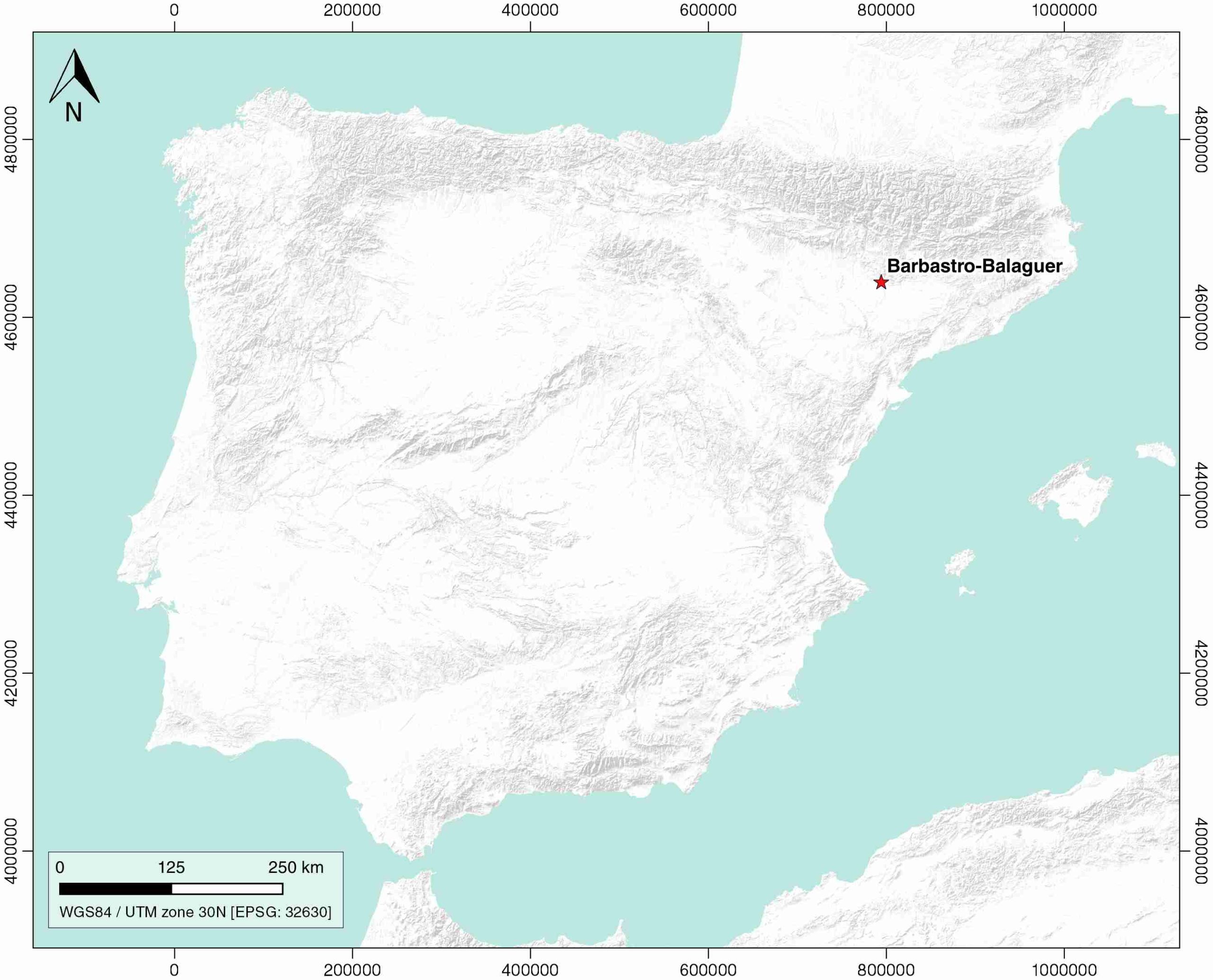
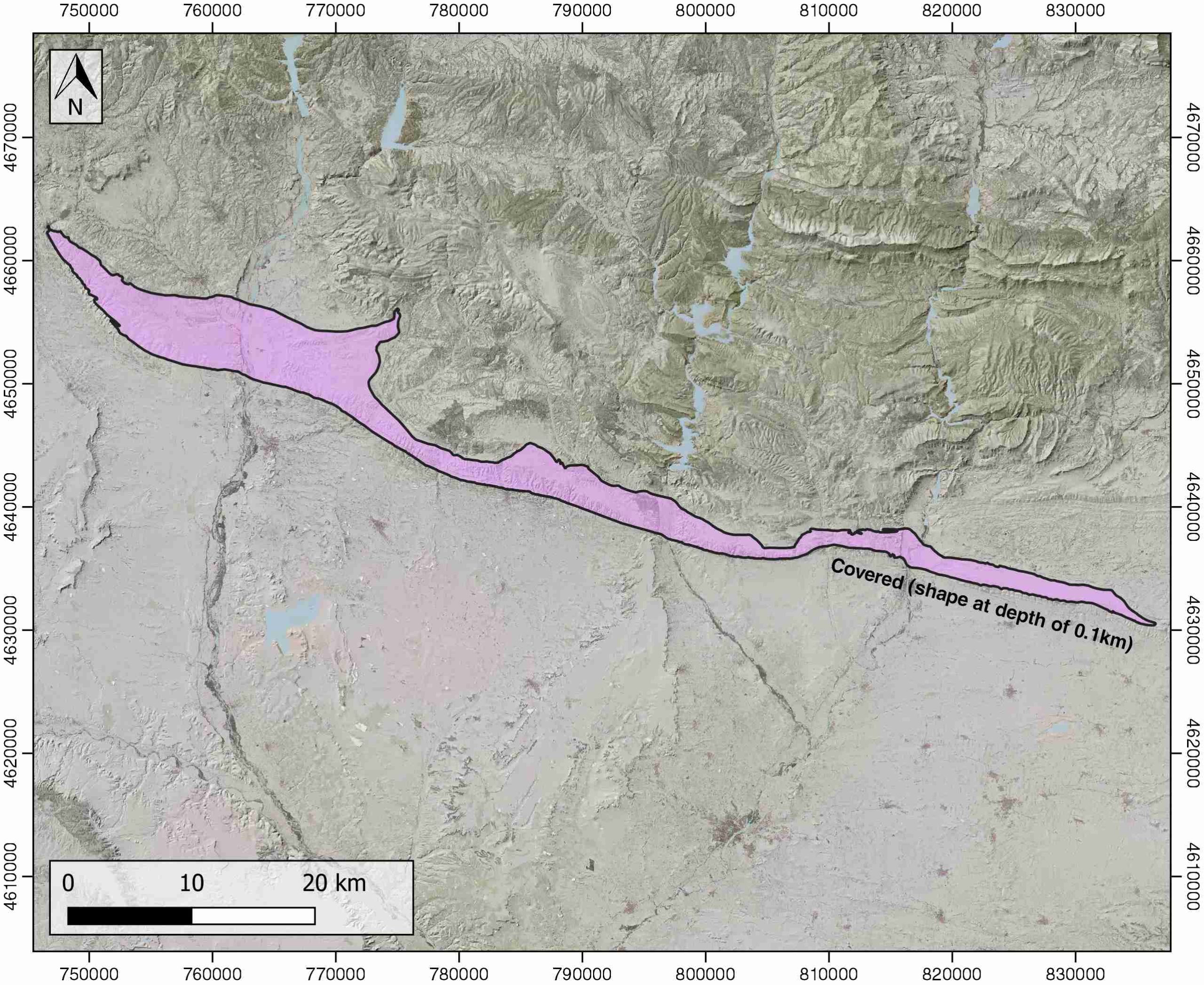
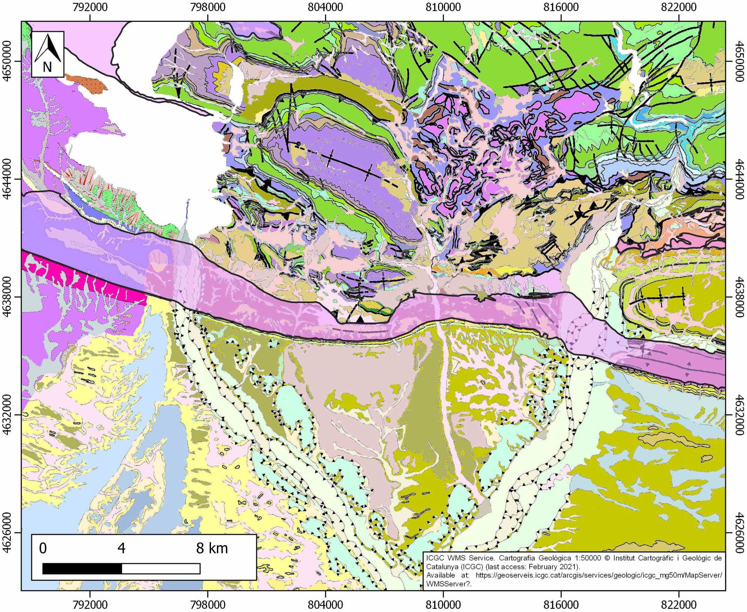
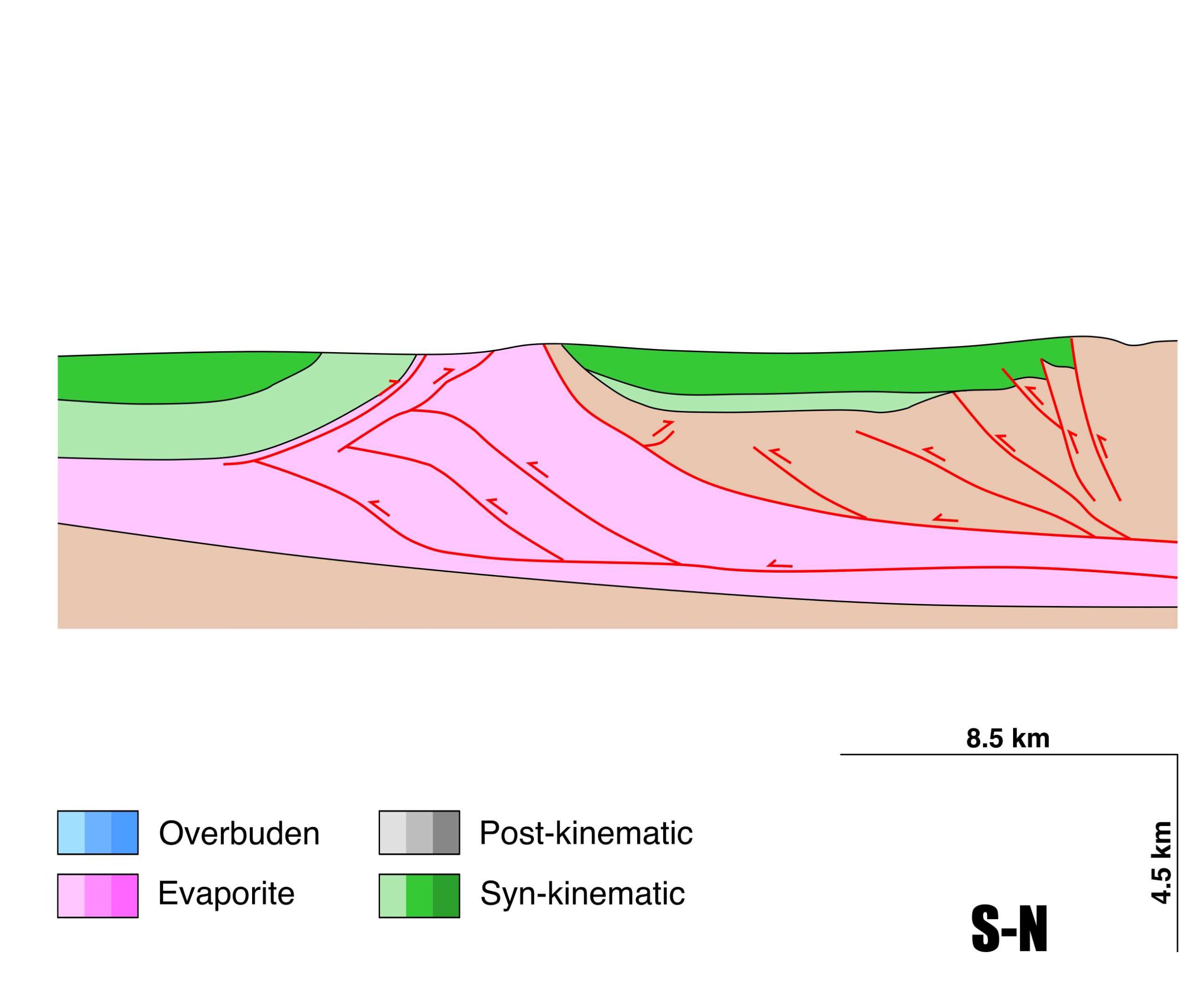
Barbastro-Balaguer
ID #102
General Information
| Structure type | Evaporite-cored anticline |
| Deformed/Undeformed | Deformed |
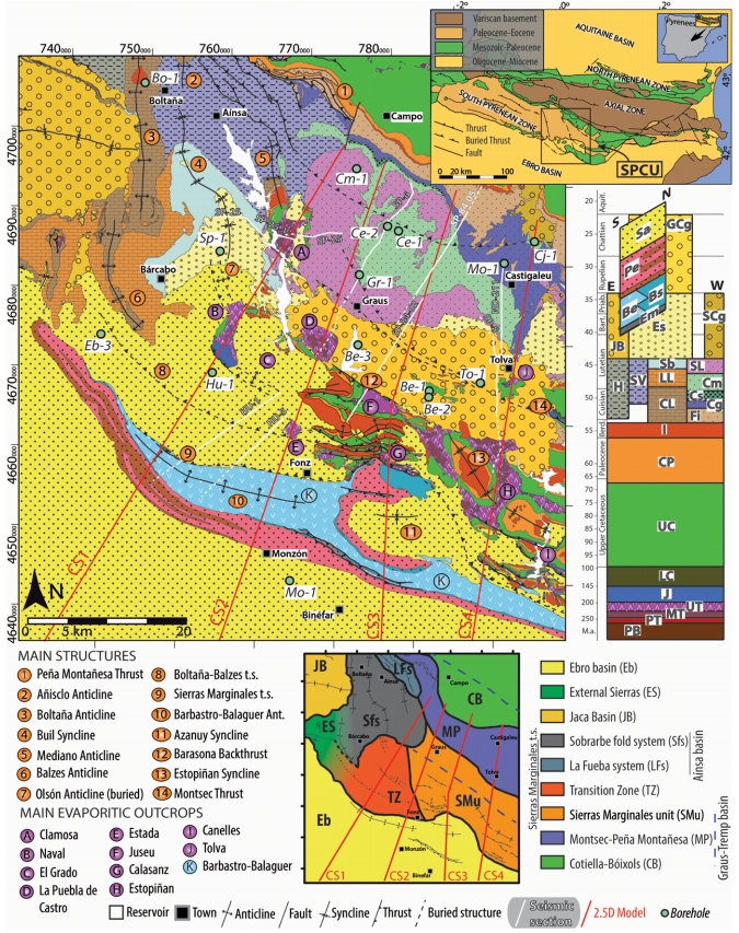
| Geological Setting | Ebro foreland basin, Northern-Central Domain |
| Outcropping/buried | Partially buried |
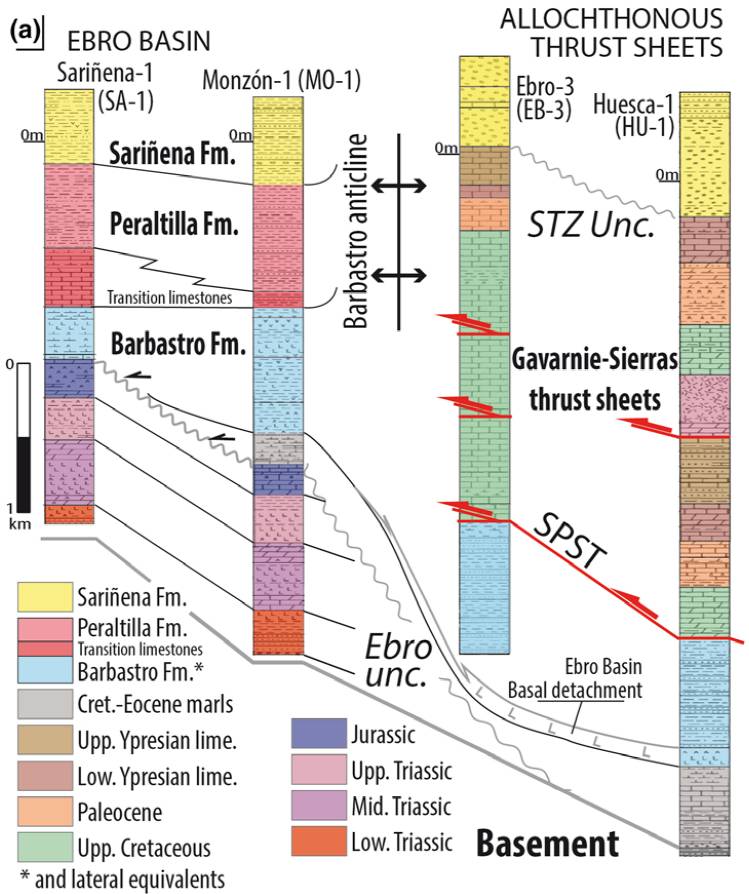
| Evaporite unit/s name | Barbastro Fm. |
| Evaporite unit/s age | Upper Priabonian-Chattian (Eocene-Oligocene) |
| Evaporite unit/s origin | Continental |
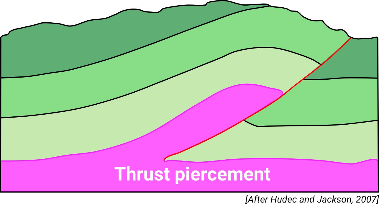
| Classif. (Hudec and Jackson, 2009) | Ductile piercement, Thrust piercement |
| Classif. (Jackson and Talbot, 1986) | Salt anticline |
| Age of evaporite flow or deformation (when deformed) | Lower Oligocene, Oligocene to Miocene |
| Other comments | Asymmetric geometry: steeply dipping beds in the southern forelimb and a low dip in the northern backlimb. Alpine thrusting stopped approximately 26 Ma ago during the Miocene. From 26 Ma ago to the present, the evaporitic flow towards the anticline core is exclusively due to buoyancy and differential loading (see Gil and Jurado, 1998). |
Generic Data
| Unique ID | 102 |
| Name | Barbastro-Balaguer |
| Structure type | Evaporite-cored anticline |
| Deformed/Undeformed | Deformed |
| Buried/Outcropping | Partially buried |
| Geological setting | Ebro Basin |
| Geological Regional Setting | Northern-Central Domain |
| Evaporite unit/s name | Barbastro Fm. |
| Evaporite unit/s age | Upper Priabonian-Chattian (Eocene-Oligocene) |
| Evaporite unit/s era | Cenozoic |
| Evaporite unit/s origin | Continental |
| Evaporite unit/s composition | Gypsum-Halite-Anhydrite-Shale |
| Post-kinematic unit/s (or post-evaporite units when evaporites are undeformed) | Pliocene (siltstones, sandstones, conglomerates) ; Quaternary (alluvial and colluvial detrital deposits) |
| Post-kinematic unit/s age (or post-evaporite units when evaporites are undeformed) | Pliocene-Holocene |
| Classification (Hudec and Jackson, 2009) | Thrust piercement / Ductile piercement |
| Classification (Jackson and Talbot, 1986) | Salt anticline |
| Mining activity? | Y |
| Mining activity start | |
| Mining activity end | Active |
| Mining galleries? | Y |
| Mining products | Gypsum |
| Mining sub-products | – |
| Evaporite flow? | Y |
| Age of evaporite flow | Early Oligocene (Early Stage) ; Late Oligocene-Late Miocene (mean stage) |
| Flow or deformation triggering mechanisms | Alpine compression and thrusting (early stage) and buoyancy and differential loading (mean stage) |
| Flow-linked structures? | Y |
| Halokinetic structures | Normal faults / anticline-syncline folding |
| Post-evaporite and pre-kinematic unit/s (overbuden) | – |
| Syn-kinematic unit/s | Rupelian (Peraltilla Fm., limestones, marly limestones, sandstones and red mudstones) ; Chattian (Sariñena Fm., sandstones and conglomerates) |
| Available seismic profiles | CW-74 / CW-93 / HU-18 / SP-58 / HU-19-P / HU-17 / SP-58 / CN-24 / SP-58 / HL-04 / HL-26 / HL-22 / HL-07 / HL-16 / CN-95 / HU-5 / HL-25 / HL-05 / PIR-86-01 / CN-23 / CN-73 |
| Available boreholes | V-16-3 / V-16-1 / V-16-2 / LG-1 / BM-1 |
| Additional comments | Asymmetric geometry: steeply dipping beds in the southern forelimb and a low dip in the northern backlimb. Alpine thrusting stopped approximately 26 Ma ago during the Miocene. From 26 Ma ago to the present, the evaporitic flow towards the anticline core is exclusively due to buoyancy and differential loading (see Gil and Jurado, 1998). |
Mining Data
| UNIQUE_ID | 102 |
| Minning exploitations within <2km? | Y |
| Historical/Active | Active |
| Exploitation name #1 | CANXINXES |
| Exploitation ID (Spanish National Mining Cadastre) #1 | 5510 |
| Municipality #1 | Alfarràs |
| Province #1 | LERIDA |
| Company #1 | BENITO ARNÓ E HIJOS, SAU (BAEHSAU) |
| Main minning Products #1 | Gypsum |
| Exploitation name #2 | SALES MONZON |
| Exploitation ID (Spanish National Mining Cadastre) #2 | 2120 |
| Municipality #2 | Castejón del Puente |
| Province #2 | HUESCA |
| Company #2 | SALES MONZON, S.A. |
| Main minning Products #2 | Gem Salt, Common salt |
| Exploitation name #3 | CASTEJON DEL PUENTE |
| Exploitation ID (Spanish National Mining Cadastre) #3 | 57 |
| Municipality #3 | Castejón del Puente |
| Province #3 | HUESCA |
| Company #3 | HORPISA (HORMIGONES DEL PIRINEO, S.A.) |
| Main minning Products #3 | Gravel and sand |
Quantitative Data
| UNIQUE_ID | 102 |
| Outcropping area (km2) | Buried |
| Horizontal intersection area (km2) (when buried) | 267.19495 |
| Depth of intersection area (km2) (when buried) | 0.1 |
| Max. Width (Km) | 12.1936891 |
| Max. Length (Km) | 95.2238547 |
| Max. Evaporites thickness (km) | 2.1 |
| Max. Deformation age (Ma) | 34 |
| Min. Deformation age (Ma) | 5 |
| Deformation stages | 2 |
Reference Data
| UNIQUE_ID | 102 |
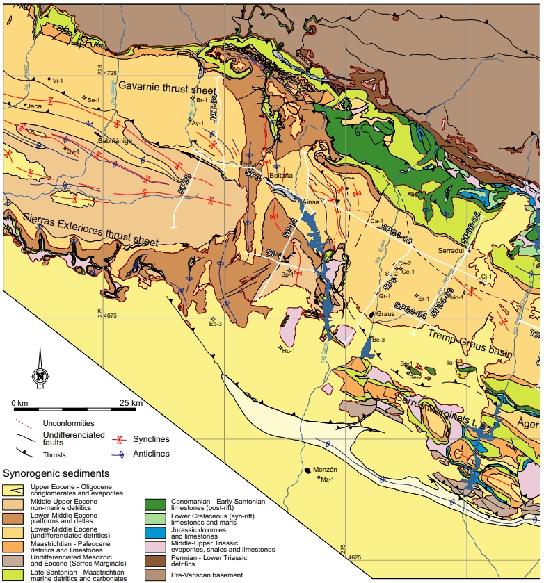
| Section source | Santolaria, P., Ayala, C., Pueyo, E. L., Rubio, F. M., Soto, R., Calvín, P., Luzón, A., Rodríguez-Pintor, A., Oliván, C., Casas‐Sainz, A. M., 2020. Structural and geophysical characterization of the western termination of the South Pyrenean triangle zone. Tectonics, 39(8), e2019TC005891. [link] |
| Well / Borehole availability #1 | Cámara, P., Flinch, J. F., 2017. The southern Pyrenees: a salt-based fold-and-thrust belt. In Juan I. Soto, Joan F. Flinch, Gabor Tari (eds.): Permo-Triassic Salt Provinces of Europe, North Africa and the Atlantic Margins, Elsevier, pp. 395-415. [link] |
| Well / Borehole availability #2 | Vargas, H., Gaspar-Escribano, J. M., López-Gómez, J., Van Wees, J. D., Cloetingh, S., de La Horra, R., Arche, A., 2009. A comparison of the Iberian and Ebro Basins during the Permian and Triassic, eastern Spain: A quantitative subsidence modelling approach. Tectonophysics, 474(1-2), 160-183. [link] |
| Available data (Stratigraphy) #1 | Senz, J. G., Zamorano, M., 1992. Evolución tectónica y sedimentaria durante el Priaboniense superior-Mioceno inferior, en el frente de cabalgamiento de las Sierras Marginales occidentales. Acta geológica hispánica, 27(1-2), 195-209. [link] |
| Available data (Stratigraphy) #2 | Santolaria, P., Casas-Sainz, A. M., Soto, R., Casas, A., 2017. Gravity modelling to assess salt tectonics in the western end of the South Pyrenean Central Unit. Journal of the Geological Society, 174(2), 269-288. [link] |
| Available data (Stratigraphy) #3 | Santolaria, P., Ayala, C., Pueyo, E. L., Rubio, F. M., Soto, R., Calvín, P., Luzón, A., Rodríguez-Pintor, A., Oliván, C., Casas‐Sainz, A. M., 2020. Structural and geophysical characterization of the western termination of the South Pyrenean triangle zone. Tectonics, 39(8), e2019TC005891. [link] |
| Available data (Stratigraphy) #4 | Calvet, M., Gunnell, Y., Laumonier, B., 2020. Denudation history and palaeogeography of the Pyrenees and their peripheral basins: an 84-million-year geomorphological perspective. Earth-Science Reviews, 103436. [link] |
| Available data (Stratigraphy) #5 | Lucha, P., Gutiérrez, F., Galve, J. P., Guerrero, J., 2012. Geomorphic and stratigraphic evidence of incision-induced halokinetic uplift and dissolution subsidence in transverse drainages crossing the evaporite-cored Barbastro–Balaguer Anticline (Ebro Basin, NE Spain). Geomorphology, 171, 154-172. [link] |
| Available data (Stratigraphy) #6 | Cámara, P., Flinch, J. F., 2017. The southern Pyrenees: a salt-based fold-and-thrust belt. In Juan I. Soto, Joan F. Flinch, Gabor Tari (eds.): Permo-Triassic Salt Provinces of Europe, North Africa and the Atlantic Margins, Elsevier, pp. 395-415. [link] |
| Regional Stratigraphy | Santolaria, P., Ayala, C., Pueyo, E. L., Rubio, F. M., Soto, R., Calvín, P., …, Casas‐Sainz, A. M., 2020. Structural and geophysical characterization of the western termination of the South Pyrenean triangle zone. Tectonics, 39(8), e2019TC005891. [link] |
| Seismic data availability #1 | Santolaria, P., Casas-Sainz, A. M., Soto, R., Casas, A., 2017. Gravity modelling to assess salt tectonics in the western end of the South Pyrenean Central Unit. Journal of the Geological Society, 174(2), 269-288. [link] |
| Seismic data availability #2 | Gil, J. A., Jurado, M. J., 1998. Geological interpretation and numerical modelling of salt movement in the Barbastro–Balaguer anticline, southern Pyrenees. Tectonophysics, 293(3-4), 141-155. [link] |
| Seismic data availability #3 | Santolaria, P., Ayala, C., Pueyo, E. L., Rubio, F. M., Soto, R., Calvín, P., Luzón, A., Rodríguez-Pintor, A., Oliván, C., Casas‐Sainz, A. M., 2020. Structural and geophysical characterization of the western termination of the South Pyrenean triangle zone. Tectonics, 39(8), e2019TC005891. [link] |
| Available data (Structure) #1 | Santolaria, P., Ayala, C., Pueyo, E. L., Rubio, F. M., Soto, R., Calvín, P., Luzón, A., Rodríguez-Pintor, A., Oliván, C., Casas‐Sainz, A. M., 2020. Structural and geophysical characterization of the western termination of the South Pyrenean triangle zone. Tectonics, 39(8), e2019TC005891. [link] |
| Available data (Structure) #2 | Peña, B. M., Pocoví, J. A., 1988. El amortiguamiento frontal de la estructura de la cobertera surpirenaica y su relación con el anticlinal de Barbastro-Balaguer. Acta geológica hispánica, 81-94. [link] |
| Available data (Structure) #3 | Gil, J. A., Jurado, M. J., 1998. Geological interpretation and numerical modelling of salt movement in the Barbastro–Balaguer anticline, southern Pyrenees. Tectonophysics, 293(3-4), 141-155. [link] |
| Available data (Structure) #4 | Santolaria, P., Calvín, P., Soto Marín, R. L., Casas, A. M., Luzón Aguado, M. A., Pueyo Morer, E. L., 2016. Nuevas aportaciones sobre la estructura de la terminación occidental del anticlinal de Barbastro-Balaguer. Geo-Temas, 16, 77-80. [link] |
| Available data (Structure) #5 | Santolaria, P., Casas-Sainz, A. M., Soto, R., Casas, A., 2017. Gravity modelling to assess salt tectonics in the western end of the South Pyrenean Central Unit. Journal of the Geological Society, 174(2), 269-288. [link] |
| Available data (Structure) #6 | Cámara, P., Flinch, J. F., 2017. The southern Pyrenees: a salt-based fold-and-thrust belt. In Juan I. Soto, Joan F. Flinch, Gabor Tari (eds.): Permo-Triassic Salt Provinces of Europe, North Africa and the Atlantic Margins, Elsevier, pp. 395-415. [link] |
| Available data (Analogue modelling) #1 | Gil, J. A., Jurado, M. J., 1998. Geological interpretation and numerical modelling of salt movement in the Barbastro–Balaguer anticline, southern Pyrenees. Tectonophysics, 293(3-4), 141-155. [link] |
| Available data (Analogue modelling) #2 | n.a. |
| Available data (Analogue modelling) #3 | n.a. |
| Available data (Gravimetry – Tomography) #1 | Santolaria, P., Casas-Sainz, A. M., Soto, R., Casas, A., 2017. Gravity modelling to assess salt tectonics in the western end of the South Pyrenean Central Unit. Journal of the Geological Society, 174(2), 269-288. [link] |
| Available data (Gravimetry – Tomography) #2 | Santolaria, P., Rubio, F. M., Ayala, C., Pueyo, E. L., Rodríguez-Pintó, A., Soto, R., Casas, A. M., 2016. Gravimetría preliminar del antepaís Pirenaico central; distribución de las evaporitas y geometría de zócalo. [link] |
| Available data (Gravimetry – Tomography) #3 | Santolaria, P., Ayala, C., Pueyo, E. L., Rubio, F. M., Soto, R., Calvín, P., Luzón, A., Rodríguez-Pintor, A., Oliván, C., Casas‐Sainz, A. M., 2020. Structural and geophysical characterization of the western termination of the South Pyrenean triangle zone. Tectonics, 39(8), e2019TC005891. [link] |
| Available data (Geochemistry) #1 | Cendón Sevilla, D. I., 1999. Evolución geoquímica de cuencas evaporíticas terciarias: implicaciones en la composición isotópica disuelto en el océano durante el terciario [Ph.D. thesis]: University of Barcelona, 335p. [link] |
| Available data (Geochemistry) #2 | n.a. |
| Available data (Geochemistry) #3 | n.a. |
| Available data (Geochemistry) #4 | n.a. |
| Available data (Petrophysics) #1 | Santolaria, P., Casas-Sainz, A. M., Soto, R., Casas, A., 2017. Gravity modelling to assess salt tectonics in the western end of the South Pyrenean Central Unit. Journal of the Geological Society, 174(2), 269-288. [link] |
| Available data (Petrophysics) #2 | Oliván, C., Pueyo, E. L., Pocoví, A., Luzón, A., Martínez-Peña, M. B., 2008. Fábricas magnéticas (ASM) en el anticlinal de Barbastro–Balaguer (Pirineo Central): implicaciones cinemáticas. Geotemas, 10, 1239-1242. [link] |
| IGME Geological Map (MAGNA50) Sheet number | 287-Barbastro. [link] and 326-Monzón. [link] and 327-Os de Balaguer. [link] and 359-Balaguer. [link] |
| Other Maps #1 (source) | Muñoz, J. A., Mencos, J., Roca, E., Carrera, N., Gratacós, O., Ferrer, O., Fernández, O., 2018. The structure of the South-Central-Pyrenean fold and thrust belt as constrained by subsurface data. Geologica Acta, 16(4), 439-460. [link] |
| Other Maps #2 (source) | Santolaria, P., Casas-Sainz, A. M., Soto, R., Casas, A., 2017. Gravity modelling to assess salt tectonics in the western end of the South Pyrenean Central Unit. Journal of the Geological Society, 174(2), 269-288. [link] |
| Other related references #1 | Torné, M., 1989. Modelización gravimétrica en 3d de un sector de la depresión central catalana y sierras marginales. Revista de la Sociedad Geológica de España, 2, 133-142. [link] |
| Other related references #2 | Lucha, P., Gutiérrez, F., Guerrero, J., 2008. Environmental problems and geological implications derived from evaporite dissolution in the Barbastro salt anticline (NE Spain). Environmental geology, 53(5), 1045-1055. [link] |
| Other related references #3 | Muñoz, J. A., Mencos, J., Roca, E., Carrera, N., Gratacós, O., Ferrer, O., Fernández, O., 2018. The structure of the South-Central-Pyrenean fold and thrust belt as constrained by subsurface data. Geologica Acta, 16(4), 439-460. [link] |
| Other related references #4 | Muñoz, J. A., 2019. Alpine Orogeny: Deformation and Structure in the Northern Iberian Margin (Pyrenees sl). In The Geology of Iberia: A Geodynamic Approach (pp. 433-451). Springer, Cham. [link] |
Well and Seismic Data
| UNIQUE_ID | 102 |
| Seismic survey name #1 | 11D-ST-157 |
| Across structure? #1 | Y |
| Seismic profile ID (IGME) #1 | 14131 |
| Seismic profile code #1 | 18866 |
| Seismic profile name #1 | CW-74 |
| Seismic survey year #1 | 1962 |
| Data repository #1 | SIGEOF Data Catalogue (Private access section). ©Instituto Geológico y Minero de España (IGME). https://info.igme.es/SIGEOF/ |
| Length (km) #1 | 23.67 |
| Seismic survey name #2 | 10D-ST-157 |
| Across structure? #2 | Y |
| Seismic profile ID (IGME) #2 | 13865 |
| Seismic profile code #2 | 18586 |
| Seismic profile name #2 | CW-93 |
| Seismic survey year #2 | 1962 |
| Data repository #2 | SIGEOF Data Catalogue (Private access section). ©Instituto Geológico y Minero de España (IGME). https://info.igme.es/SIGEOF/ |
| Length (km) #2 | 11.07 |
| Seismic survey name #3 | 10D1-HU |
| Across structure? #3 | Y |
| Seismic profile ID (IGME) #3 | 10080 |
| Seismic profile code #3 | 14653 |
| Seismic profile name #3 | HU-18 |
| Seismic survey year #3 | 1979 |
| Data repository #3 | SIGEOF Data Catalogue (Section available under request). ©Instituto Geológico y Minero de España (IGME). https://info.igme.es/SIGEOF/ |
| Length (km) #3 | 15.10 |
| Seismic survey name #4 | 0116A80U |
| Across structure? #4 | Y |
| Seismic profile ID (IGME) #4 | 5556 |
| Seismic profile code #4 | 8458 |
| Seismic profile name #4 | SP-58 |
| Seismic survey year #4 | 1980 |
| Data repository #4 | SIGEOF Data Catalogue (Private access section). ©Instituto Geológico y Minero de España (IGME). https://info.igme.es/SIGEOF/ |
| Length (km) #4 | 19.58 |
| Seismic survey name #5 | 10D1-HU |
| Across structure? #5 | Y |
| Seismic profile ID (IGME) #5 | 10078 |
| Seismic profile code #5 | 14651 |
| Seismic profile name #5 | HU-19-P |
| Seismic survey year #5 | 1979 |
| Data repository #5 | SIGEOF Data Catalogue (Section available under request). ©Instituto Geológico y Minero de España (IGME). https://info.igme.es/SIGEOF/ |
| Length (km) #5 | 12.33 |
| Seismic survey name #6 | 10D1-HU |
| Across structure? #6 | Y |
| Seismic profile ID (IGME) #6 | 10081 |
| Seismic profile code #6 | 14654 |
| Seismic profile name #6 | HU-17 |
| Seismic survey year #6 | 1979 |
| Data repository #6 | SIGEOF Data Catalogue (Section available under request). ©Instituto Geológico y Minero de España (IGME). https://info.igme.es/SIGEOF/ |
| Length (km) #6 | 16.46 |
| Seismic survey name #7 | 0116A80G |
| Across structure? #7 | Y |
| Seismic profile ID (IGME) #7 | 5394 |
| Seismic profile code #7 | 7762 |
| Seismic profile name #7 | SP-58 |
| Seismic survey year #7 | 1980 |
| Data repository #7 | SIGEOF Data Catalogue (Private access section). ©Instituto Geológico y Minero de España (IGME). https://info.igme.es/SIGEOF/ |
| Length (km) #7 | 19.59 |
| Seismic survey name #8 | 11D-C003 |
| Across structure? #8 | Y |
| Seismic profile ID (IGME) #8 | 14086 |
| Seismic profile code #8 | 18820 |
| Seismic profile name #8 | CN-24 |
| Seismic survey year #8 | |
| Data repository #8 | SIGEOF Data Catalogue (Private access section). ©Instituto Geológico y Minero de España (IGME). https://info.igme.es/SIGEOF/ |
| Length (km) #8 | 29.38 |
| Seismic survey name #9 | 0116A80S |
| Across structure? #9 | Y |
| Seismic profile ID (IGME) #9 | 5523 |
| Seismic profile code #9 | 8425 |
| Seismic profile name #9 | SP-58 |
| Seismic survey year #9 | 1980 |
| Data repository #9 | SIGEOF Data Catalogue (Private access section). ©Instituto Geológico y Minero de España (IGME). https://info.igme.es/SIGEOF/ |
| Length (km) #9 | 18.91 |
| Seismic survey name #10 | DHLS |
| Across structure? #10 | Y |
| Seismic profile ID (IGME) #10 | 5617 |
| Seismic profile code #10 | 8641 |
| Seismic profile name #10 | HL-04 |
| Seismic survey year #10 | |
| Data repository #10 | SIGEOF Data Catalogue (Private access section). ©Instituto Geológico y Minero de España (IGME). https://info.igme.es/SIGEOF/ |
| Length (km) #10 | 61.78 |
| Seismic survey name #11 | DHLS |
| Across structure? #11 | Y |
| Seismic profile ID (IGME) #11 | 5632 |
| Seismic profile code #11 | 8656 |
| Seismic profile name #11 | HL-26 |
| Seismic survey year #11 | |
| Data repository #11 | SIGEOF Data Catalogue (Private access section). ©Instituto Geológico y Minero de España (IGME). https://info.igme.es/SIGEOF/ |
| Length (km) #11 | 8.67 |
| Seismic survey name #12 | DHLS |
| Across structure? #12 | Y |
| Seismic profile ID (IGME) #12 | 5629 |
| Seismic profile code #12 | 8653 |
| Seismic profile name #12 | HL-22 |
| Seismic survey year #12 | |
| Data repository #12 | SIGEOF Data Catalogue (Private access section). ©Instituto Geológico y Minero de España (IGME). https://info.igme.es/SIGEOF/ |
| Length (km) #12 | 4.73 |
| Seismic survey name #13 | DHLS |
| Across structure? #13 | Y |
| Seismic profile ID (IGME) #13 | 5620 |
| Seismic profile code #13 | 8644 |
| Seismic profile name #13 | HL-07 |
| Seismic survey year #13 | |
| Data repository #13 | SIGEOF Data Catalogue (Private access section). ©Instituto Geológico y Minero de España (IGME). https://info.igme.es/SIGEOF/ |
| Length (km) #13 | 33.10 |
| Seismic survey name #14 | DHLS |
| Across structure? #14 | Y |
| Seismic profile ID (IGME) #14 | 5625 |
| Seismic profile code #14 | 8649 |
| Seismic profile name #14 | HL-16 |
| Seismic survey year #14 | |
| Data repository #14 | SIGEOF Data Catalogue (Private access section). ©Instituto Geológico y Minero de España (IGME). https://info.igme.es/SIGEOF/ |
| Length (km) #14 | 74.77 |
| Seismic survey name #15 | 11D-C003 |
| Across structure? #15 | Y |
| Seismic profile ID (IGME) #15 | 14082 |
| Seismic profile code #15 | 18816 |
| Seismic profile name #15 | CN-95 |
| Seismic survey year #15 | |
| Data repository #15 | SIGEOF Data Catalogue (Private access section). ©Instituto Geológico y Minero de España (IGME). https://info.igme.es/SIGEOF/ |
| Length (km) #15 | 8.86 |
| Seismic survey name #16 | 10D1-HU |
| Across structure? #16 | Y |
| Seismic profile ID (IGME) #16 | 10065 |
| Seismic profile code #16 | 14638 |
| Seismic profile name #16 | HU-5 |
| Seismic survey year #16 | 1979 |
| Data repository #16 | SIGEOF Data Catalogue (Section available under request). ©Instituto Geológico y Minero de España (IGME). https://info.igme.es/SIGEOF/ |
| Length (km) #16 | 15.07 |
| Seismic survey name #17 | DHLS |
| Across structure? #17 | Y |
| Seismic profile ID (IGME) #17 | 5631 |
| Seismic profile code #17 | 8655 |
| Seismic profile name #17 | HL-25 |
| Seismic survey year #17 | |
| Data repository #17 | SIGEOF Data Catalogue (Private access section). ©Instituto Geológico y Minero de España (IGME). https://info.igme.es/SIGEOF/ |
| Length (km) #17 | 12.61 |
| Seismic survey name #18 | DHLS |
| Across structure? #18 | Y |
| Seismic profile ID (IGME) #18 | 5618 |
| Seismic profile code #18 | 8642 |
| Seismic profile name #18 | HL-05 |
| Seismic survey year #18 | |
| Data repository #18 | SIGEOF Data Catalogue (Private access section). ©Instituto Geológico y Minero de España (IGME). https://info.igme.es/SIGEOF/ |
| Length (km) #18 | 37.36 |
| Seismic survey name #19 | 0519A86S |
| Across structure? #19 | Y |
| Seismic profile ID (IGME) #19 | 5458 |
| Seismic profile code #19 | 7882 |
| Seismic profile name #19 | PIR-86-01 |
| Seismic survey year #19 | 1986 |
| Data repository #19 | SIGEOF Data Catalogue (Section available under request). ©Instituto Geológico y Minero de España (IGME). https://info.igme.es/SIGEOF/ |
| Length (km) #19 | 75.97 |
| Seismic survey name #20 | 11D-C003 |
| Across structure? #20 | Y |
| Seismic profile ID (IGME) #20 | 14087 |
| Seismic profile code #20 | 18821 |
| Seismic profile name #20 | CN-23 |
| Seismic survey year #20 | |
| Data repository #20 | SIGEOF Data Catalogue (Private access section). ©Instituto Geológico y Minero de España (IGME). https://info.igme.es/SIGEOF/ |
| Length (km) #20 | 13.39 |
| Seismic survey name #21 | 11D-C003 |
| Across structure? #21 | Y |
| Seismic profile ID (IGME) #21 | 14085 |
| Seismic profile code #21 | 18819 |
| Seismic profile name #21 | CN-73 |
| Seismic survey year #21 | |
| Data repository #21 | SIGEOF Data Catalogue (Private access section). ©Instituto Geológico y Minero de España (IGME). https://info.igme.es/SIGEOF/ |
| Length (km) #21 | 17.28 |
| Borehole name #1 | V-16-3 |
| Company #1 | ADARO |
| Traget #1 | GYPSUM |
| Across structure? #1 | Y |
| Borehole name #2 | V-16-1 |
| Company #2 | ADARO |
| Traget #2 | GYPSUM |
| Across structure? #2 | Y |
| Borehole name #3 | V-16-2 |
| Company #3 | ADARO |
| Traget #3 | GYPSUM |
| Across structure? #3 | Y |
| Borehole name #4 | LG-1 |
| Company #4 | ENRESA |
| Traget #4 | GENERAL GEOLOGY |
| Across structure? #4 | N (within 5 km) |
| Borehole name #5 | BM-1 |
| Company #5 | ENRESA |
| Traget #5 | GENERAL GEOLOGY |
| Across structure? #5 | N (within 5 km) |
| Borehole name #6 | |
| Company #6 | |
| Traget #6 | |
| Across structure? #6 | |
| Borehole name #7 | |
| Company #7 | |
| Traget #7 | |
| Across structure? #7 | |
| Borehole name #8 | |
| Company #8 | |
| Traget #8 | |
| Across structure? #8 | |
| Borehole name #9 | |
| Company #9 | |
| Traget #9 | |
| Across structure? #9 | |
| Borehole name #10 | |
| Company #10 | |
| Traget #10 | |
| Across structure? #10 | |
| Borehole name #11 | |
| Company #11 | |
| Traget #11 | |
| Across structure? #11 | |
| Borehole name #12 | |
| Company #12 | |
| Traget #12 | |
| Across structure? #12 | |
| Borehole name #13 | |
| Company #13 | |
| Traget #13 | |
| Across structure? #13 | |
| Borehole name #14 | |
| Company #14 | |
| Traget #14 | |
| Across structure? #14 | |
| Borehole name #15 | |
| Company #15 | |
| Traget #15 | |
| Across structure? #15 |
Geographical Data (EPSG:4326 - WGS 84)
| UNIQUE_ID | 102 |
| X Centroid (Structure shape) | 0.384033 |
| Y Centroid (Structure shape) | 0.384033 |
| Xmin (Structure shape) | -0.019426 |
| Xmax (Structure shape) | 1.047352 |
| Ymin (Structure shape) | 41.754052 |
| Ymax (Structure shape) | 42.078554 |
| Xmin seismic line #1 | 0.079363 |
| Xmax seismic line #1 | 0.318599 |
| Ymin seismic line #1 | 41.890488 |
| Ymax seismic line #1 | 41.997048 |
| Xmin seismic line #2 | 0.071755 |
| Xmax seismic line #2 | 0.149834 |
| Ymin seismic line #2 | 41.890350 |
| Ymax seismic line #2 | 41.970756 |
| Xmin seismic line #3 | -0.014773 |
| Xmax seismic line #3 | 0.140253 |
| Ymin seismic line #3 | 41.989417 |
| Ymax seismic line #3 | 42.059801 |
| Xmin seismic line #4 | 0.170011 |
| Xmax seismic line #4 | 0.286791 |
| Ymin seismic line #4 | 42.006245 |
| Ymax seismic line #4 | 42.157415 |
| Xmin seismic line #5 | 0.106704 |
| Xmax seismic line #5 | 0.170265 |
| Ymin seismic line #5 | 42.017192 |
| Ymax seismic line #5 | 42.117583 |
| Xmin seismic line #6 | 0.053040 |
| Xmax seismic line #6 | 0.220501 |
| Ymin seismic line #6 | 42.011332 |
| Ymax seismic line #6 | 42.090506 |
| Xmin seismic line #7 | 0.170011 |
| Xmax seismic line #7 | 0.286791 |
| Ymin seismic line #7 | 42.006245 |
| Ymax seismic line #7 | 42.157415 |
| Xmin seismic line #8 | 0.005427 |
| Xmax seismic line #8 | 0.198160 |
| Ymin seismic line #8 | 41.793335 |
| Ymax seismic line #8 | 42.011887 |
| Xmin seismic line #9 | 0.172456 |
| Xmax seismic line #9 | 0.285402 |
| Ymin seismic line #9 | 42.013993 |
| Ymax seismic line #9 | 42.156278 |
| Xmin seismic line #10 | -0.152217 |
| Xmax seismic line #10 | 0.266124 |
| Ymin seismic line #10 | 41.584284 |
| Ymax seismic line #10 | 42.006551 |
| Xmin seismic line #11 | 0.406156 |
| Xmax seismic line #11 | 0.422880 |
| Ymin seismic line #11 | 41.879713 |
| Ymax seismic line #11 | 41.953885 |
| Xmin seismic line #12 | 0.255680 |
| Xmax seismic line #12 | 0.296847 |
| Ymin seismic line #12 | 41.978772 |
| Ymax seismic line #12 | 42.007913 |
| Xmin seismic line #13 | 0.247708 |
| Xmax seismic line #13 | 0.403406 |
| Ymin seismic line #13 | 41.736985 |
| Ymax seismic line #13 | 42.005163 |
| Xmin seismic line #14 | -0.155243 |
| Xmax seismic line #14 | 0.333793 |
| Ymin seismic line #14 | 41.461058 |
| Ymax seismic line #14 | 42.011080 |
| Xmin seismic line #15 | 0.150666 |
| Xmax seismic line #15 | 0.256404 |
| Ymin seismic line #15 | 42.001612 |
| Ymax seismic line #15 | 42.009042 |
| Xmin seismic line #16 | 0.092907 |
| Xmax seismic line #16 | 0.230227 |
| Ymin seismic line #16 | 41.995540 |
| Ymax seismic line #16 | 42.084208 |
| Xmin seismic line #17 | 0.457602 |
| Xmax seismic line #17 | 0.467993 |
| Ymin seismic line #17 | 41.869490 |
| Ymax seismic line #17 | 41.981744 |
| Xmin seismic line #18 | -0.126024 |
| Xmax seismic line #18 | 0.151983 |
| Ymin seismic line #18 | 41.746402 |
| Ymax seismic line #18 | 42.009354 |
| Xmin seismic line #19 | 0.956724 |
| Xmax seismic line #19 | 1.001253 |
| Ymin seismic line #19 | 41.526764 |
| Ymax seismic line #19 | 42.183448 |
| Xmin seismic line #20 | 0.176261 |
| Xmax seismic line #20 | 0.218269 |
| Ymin seismic line #20 | 41.895023 |
| Ymax seismic line #20 | 42.011000 |
| Xmin seismic line #21 | 0.200130 |
| Xmax seismic line #21 | 0.295175 |
| Ymin seismic line #21 | 41.839868 |
| Ymax seismic line #21 | 41.977640 |
| X borehole #1 | 0.433387 |
| Y borehole #1 | 41.899640 |
| X borehole #2 | 0.291715 |
| Y borehole #2 | 41.973529 |
| X borehole #3 | 0.337558 |
| Y borehole #3 | 41.911582 |
| X borehole #4 | 1.075785 |
| Y borehole #4 | 41.729989 |
| X borehole #5 | 0.961275 |
| Y borehole #5 | 41.772919 |
| X borehole #6 | |
| Y borehole #6 | |
| X borehole #7 | |
| Y borehole #7 | |
| X borehole #8 | |
| Y borehole #8 | |
| X borehole #9 | |
| Y borehole #9 | |
| X borehole #10 | |
| Y borehole #10 | |
| X borehole #11 | |
| Y borehole #11 | |
| X borehole #12 | |
| Y borehole #12 | |
| X borehole #13 | |
| Y borehole #13 | |
| X borehole #14 | |
| Y borehole #14 | |
| X borehole #15 | |
| Y borehole #15 |

