General Information
| Structure type | Evaporite-detached thrust |
| Deformed/Undeformed | Deformed |
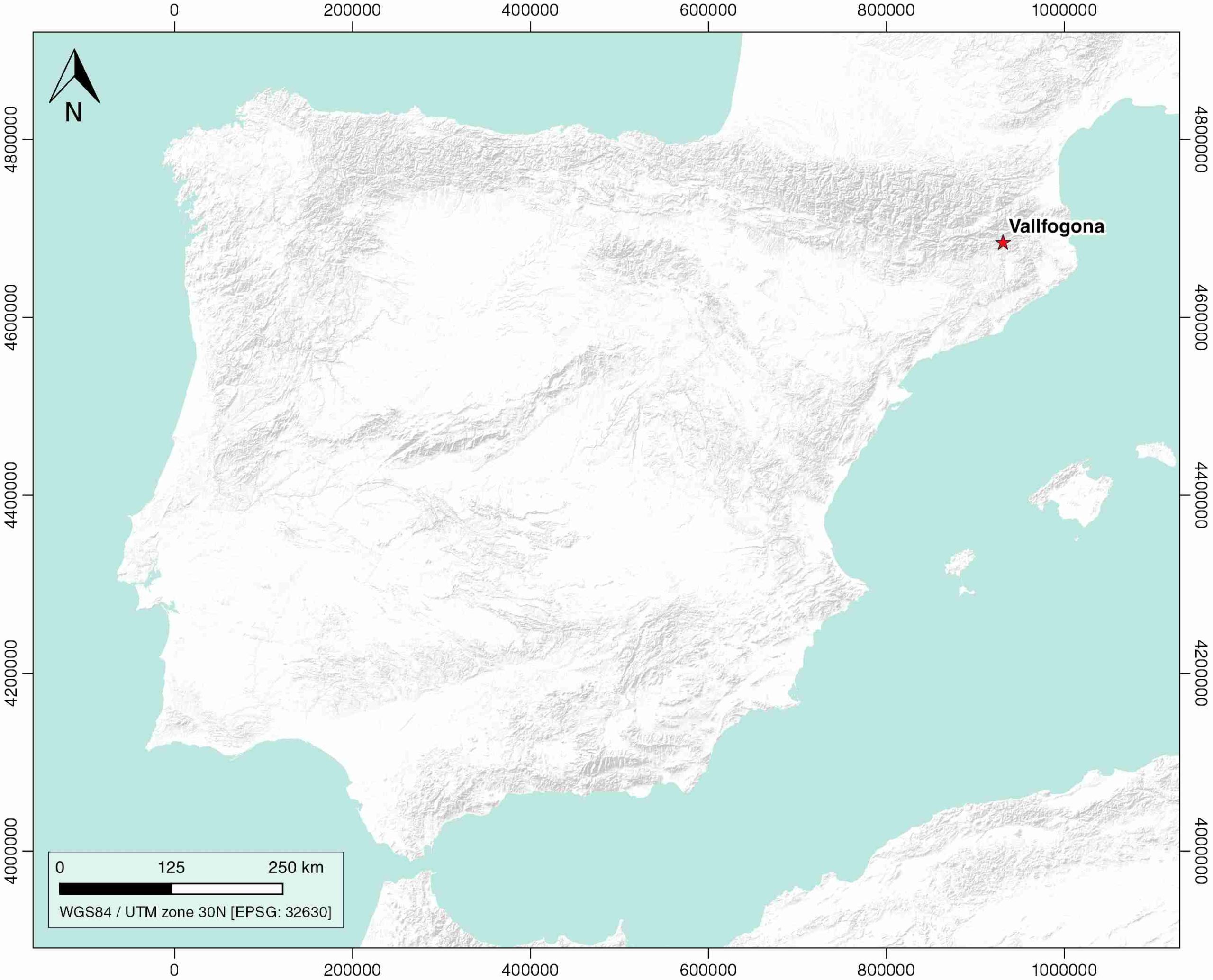
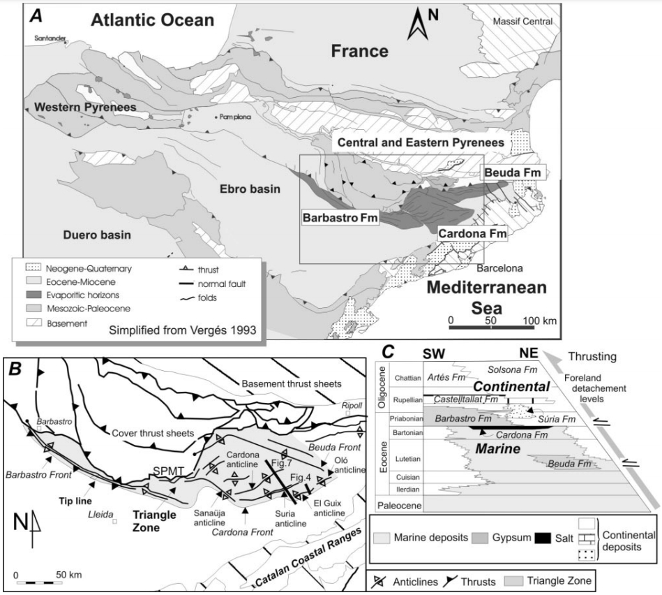
| Geological Setting | Cadí thrust sheet, Southern Pyrenees |
| Outcropping/buried | Partially buried |
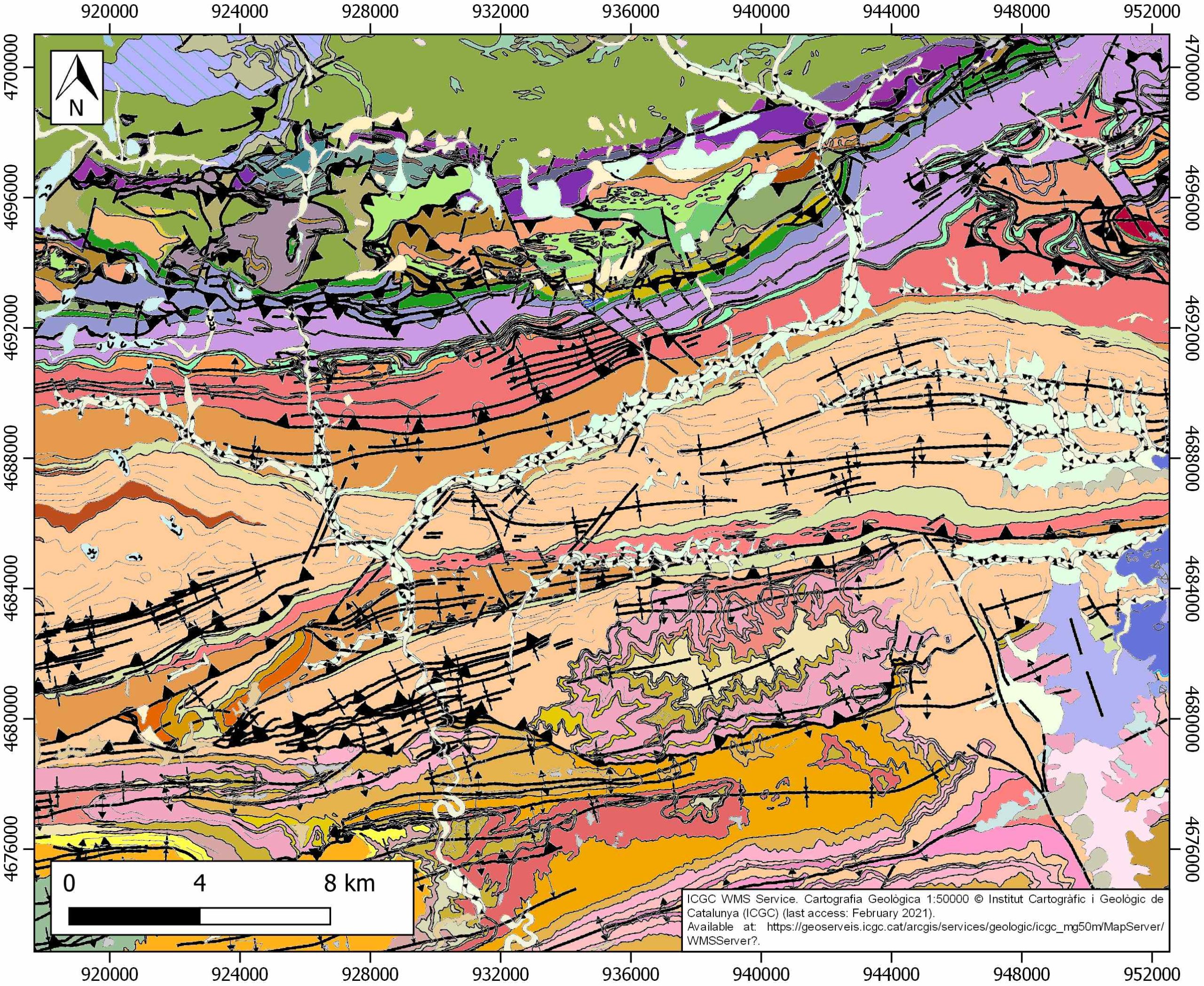
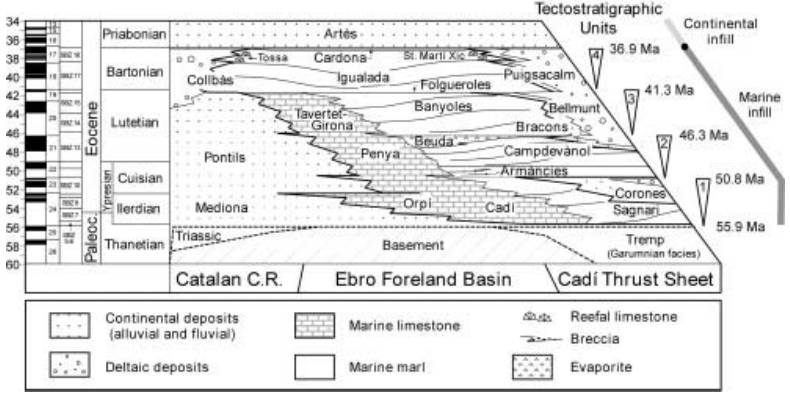
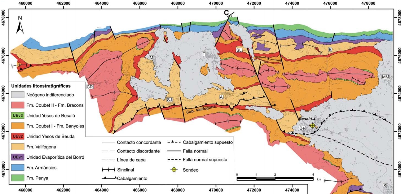
| Evaporite unit/s name | Beuda Fm., Vallfogona Fm. and Serrat Evaporites Units |
| Evaporite unit/s age | Late Cuisian-Lutetian (Eocene) |
| Evaporite unit/s origin | Marine |
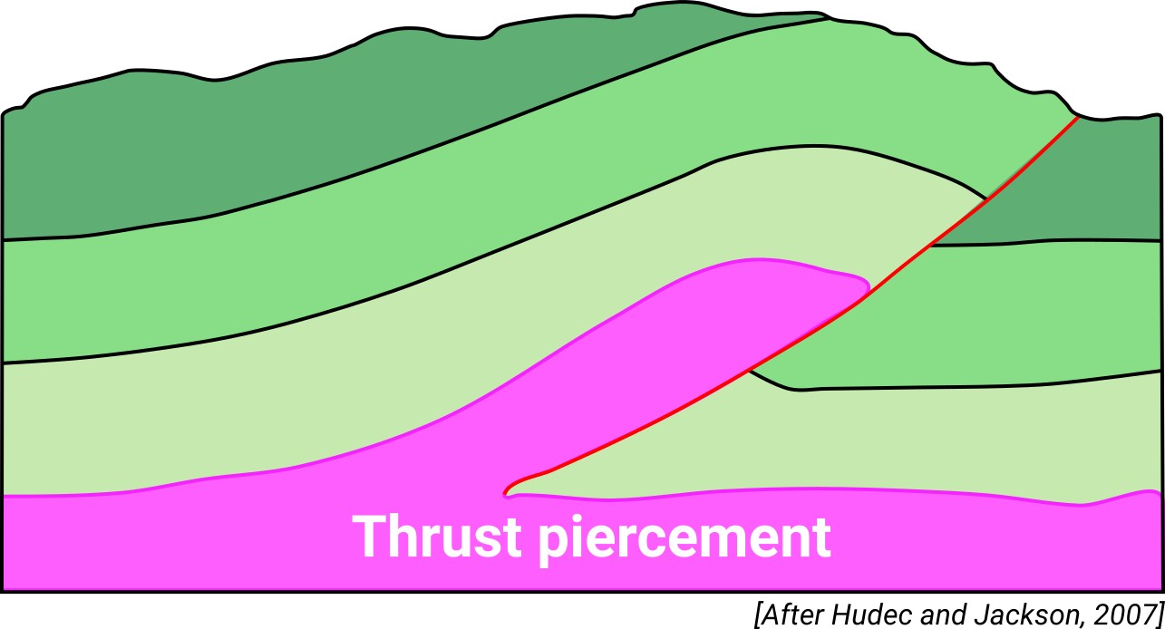
| Classif. (Hudec and Jackson, 2009) | Thrust piercement |
| Classif. (Jackson and Talbot, 1986) | |
| Age of evaporite flow or deformation (when deformed) | Eocene to Oligocene |
| Other comments | Southern boundary of the Cadí thrust sheet. Out-of sequence structures developed due to lateral stratigraphic variations of the Serrat evaporites unit. Vallfogona Fm. Mainly constituted by limestones but with interlayered laminated gypsum and gypsum breccias. |
Generic Data
| Unique ID | 112 |
| Name | Vallfogona |
| Structure type | Evaporite-detached thrust |
| Deformed/Undeformed | Deformed |
| Buried/Outcropping | Partially buried |
| Geological setting | Southern Pyrenees |
| Geological Regional Setting | Cadí thrust sheet |
| Evaporite unit/s name | Beuda Fm. / Vallfogona Fm. / Serrat evaporites unit |
| Evaporite unit/s age | Late Cuisian-Lutetian (Eocene) |
| Evaporite unit/s era | Cenozoic |
| Evaporite unit/s origin | Marine |
| Evaporite unit/s composition | Shale-Gypsum-Sandstone-Halite-Anhydrite |
| Post-kinematic unit/s (or post-evaporite units when evaporites are undeformed) | Neogene (Empordà Graben fill, gravels, sandstones and conglomerates) ; Pleistocene (siltstones and sandstones) ; Quaternary (alluvial and colluvial detrital deposits) |
| Post-kinematic unit/s age (or post-evaporite units when evaporites are undeformed) | Neogene-Holocene |
| Classification (Hudec and Jackson, 2009) | Thrust piercement |
| Classification (Jackson and Talbot, 1986) | |
| Mining activity? | N |
| Mining activity start | |
| Mining activity end | |
| Mining galleries? | |
| Mining products | |
| Mining sub-products | |
| Evaporite flow? | Y |
| Age of evaporite flow | Middle Eocene-Lower Oligocene |
| Flow or deformation triggering mechanisms | Alpine compression and southwards propagation of the Cadí thrust sheet |
| Flow-linked structures? | Y |
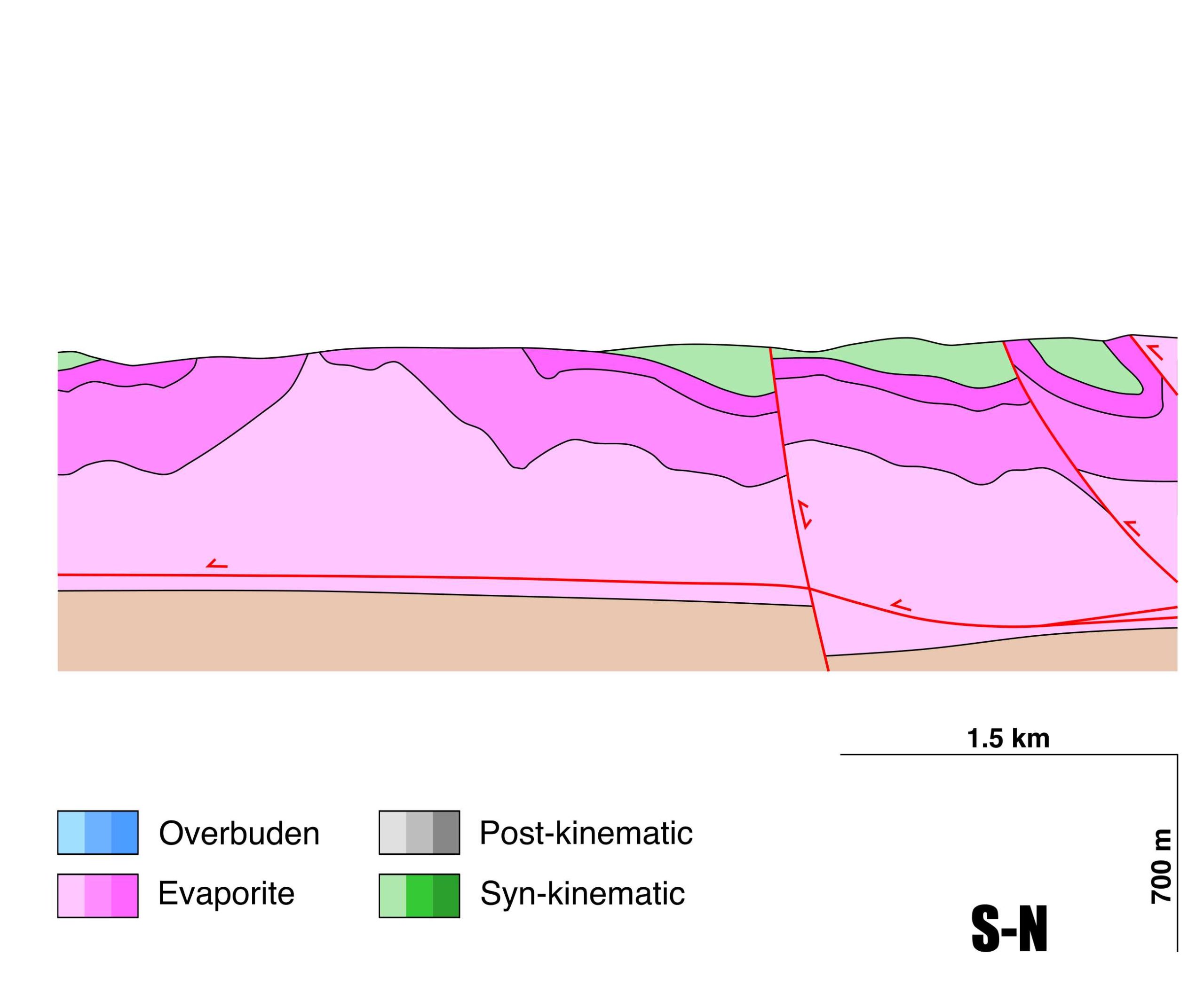
| Halokinetic structures | Out-of-sequence thrusts / anticline-syncline folding / Low-angle unconformities |
| Post-evaporite and pre-kinematic unit/s (overbuden) | – |
| Syn-kinematic unit/s | Middle-Upper Lutetian (Banyoles Fm., marlstones and shales) ; Upper Lutetian (Coubet Fm., sandstones and shales) ; Upper Lutetian (Bellumnt Fm., conglomerates and sandstones) |
| Available seismic profiles | S-23W / S-22PI2 / BE-15 / S-23W / BE-2 / UTC85-120 / UTC-8 / S-24 / S-25 / OL-2 / UTC85-104 / UTC85-103 / S-23EXT / MO-9 / MO-4-1 / S-25-BIS / S-22 / MO-3-BIS / UTC85-101 / S-24-BIS / MO-5-1 |
| Available boreholes | RIUDAURA-2 / RIUDAURA-1 / RIUDAURA-1 BIS |
| Additional comments | Southern boundary of the Cadí thrust sheet. Out-of sequence structures developed due to lateral stratigraphic variations of the Serrat evaporites unit. Vallfogona Fm. Mainly constituted by limestones but with interlayered laminated gypsum and gypsum breccias. |
Mining Data
| UNIQUE_ID | 112 |
| Minning exploitations within <2km? | N |
| Historical/Active | |
| Exploitation name #1 | |
| Exploitation ID (Spanish National Mining Cadastre) #1 | |
| Municipality #1 | |
| Province #1 | |
| Company #1 | |
| Main minning Products #1 | |
| Exploitation name #2 | |
| Exploitation ID (Spanish National Mining Cadastre) #2 | |
| Municipality #2 | |
| Province #2 | |
| Company #2 | |
| Main minning Products #2 | |
| Exploitation name #3 | |
| Exploitation ID (Spanish National Mining Cadastre) #3 | |
| Municipality #3 | |
| Province #3 | |
| Company #3 | |
| Main minning Products #3 |
Quantitative Data
| UNIQUE_ID | 112 |
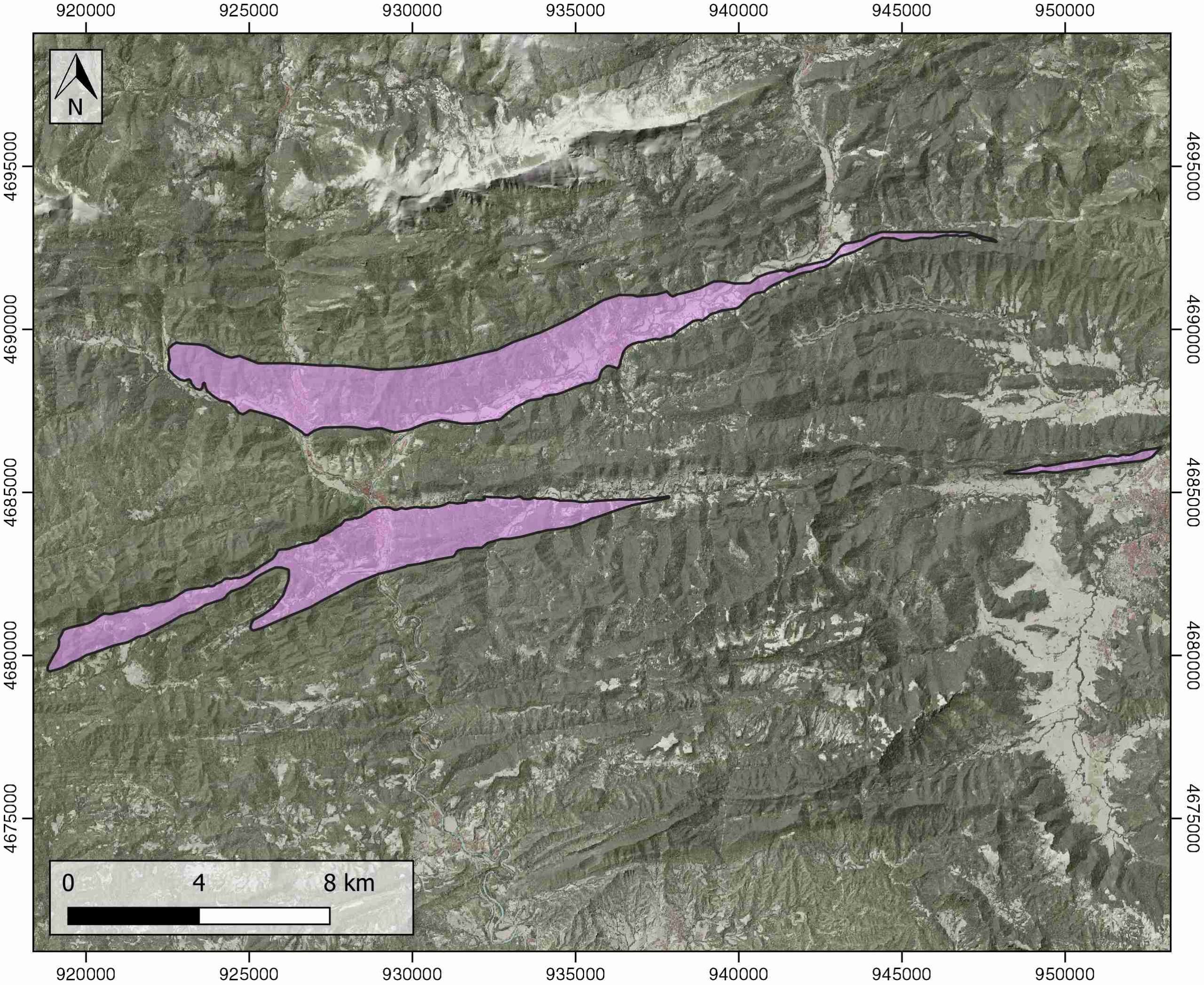
| Outcropping area (km2) | 53.28425 |
| Horizontal intersection area (km2) (when buried) | Not buried |
| Depth of intersection area (km2) (when buried) | Not buried |
| Max. Width (Km) | 9.26709427 |
| Max. Length (Km) | 34.783763 |
| Max. Evaporites thickness (km) | 1 |
| Max. Deformation age (Ma) | 42 |
| Min. Deformation age (Ma) | 32 |
| Deformation stages | 1 |
Reference Data
| UNIQUE_ID | 112 |
| Section source | Carrillo, E., Koyi, H. A., Nilfouroushan, F., 2017. Structural significance of an evaporite formation with lateral stratigraphic heterogeneities (Southeastern Pyrenean Basin, NE Spain). Marine and Petroleum Geology, 86, 1310-1326. [link] |
| Well / Borehole availability #1 | Carrillo, E., Rosell, L., Ortí, F., 2014. Multiepisodic evaporite sedimentation as an indicator of palaeogeographical evolution in foreland basins (South‐eastern Pyrenean basin, Early–Middle Eocene). Sedimentology, 61(7), 2086-2112. [link] |
| Well / Borehole availability #2 | Carrillo, E., Koyi, H. A., Nilfouroushan, F., 2017. Structural significance of an evaporite formation with lateral stratigraphic heterogeneities (Southeastern Pyrenean Basin, NE Spain). Marine and Petroleum Geology, 86, 1310-1326. [link] |
| Available data (Stratigraphy) #1 | Carrillo, E., Rosell, L., Ortí, F., 2014. Multiepisodic evaporite sedimentation as an indicator of palaeogeographical evolution in foreland basins (South‐eastern Pyrenean basin, Early–Middle Eocene). Sedimentology, 61(7), 2086-2112. [link] |
| Available data (Stratigraphy) #2 | Carrillo, E., Koyi, H. A., Nilfouroushan, F., 2017. Structural significance of an evaporite formation with lateral stratigraphic heterogeneities (Southeastern Pyrenean Basin, NE Spain). Marine and Petroleum Geology, 86, 1310-1326. [link] |
| Available data (Stratigraphy) #3 | Burbank, D. W., Puigdefàbregas, C. A. I., Munoz, J. A., 1992. The chronology of the Eocene tectonic and stratigraphic development of the eastern Pyrenean foreland basin, northeast Spain. Geological Society of America Bulletin, 104(9), 1101-1120. [link] |
| Available data (Stratigraphy) #4 | Puigdefàbregas, C., Souquet, P., 1986. Tecto-sedimentary cycles and depositional sequences of the Mesozoic and Tertiary from the Pyrenees. Tectonophysics, 129(1-4), 173-203. [link] |
| Available data (Stratigraphy) #5 | Martinez, A., Vergés, J., Clavell, E., Kennedy, J., 1989. Stratigraphic framework of the thrust geometry and structural inversion in the southeastern Pyrenees: La Garrotxa area. Geodinamica Acta, 3(3), 185-194. [link] |
| Available data (Stratigraphy) #6 | Travé, A., Labaume, P., Vergés, J., 2007. Fluid systems in foreland fold-and-thrust belts: an overview from the Southern Pyrenees. In Thrust belts and foreland basins (pp. 93-115). Springer, Berlin, Heidelberg. [link] |
| Regional Stratigraphy | Carrillo, E., 2009. Unidades evaporíticas eocenas de la Zona Surpirenaica Oriental (Área de La Garrotxa). Geogaceta, 47, 73-76. [link] |
| Seismic data availability #1 | Vergés, J., Marzo, M., Santaeulària, T., Serra-Kiel, J., Burbank, D. W., Muñoz, J. A., Giménez-Montsant, J., 1998. Quantified vertical motions and tectonic evolution of the SE Pyrenean foreland basin. Geological Society, London, Special Publications, 134(1), 107-134. [link] |
| Seismic data availability #2 | Carrillo, E., Koyi, H. A., Nilfouroushan, F., 2017. Structural significance of an evaporite formation with lateral stratigraphic heterogeneities (Southeastern Pyrenean Basin, NE Spain). Marine and Petroleum Geology, 86, 1310-1326. [link] |
| Seismic data availability #3 | Martínez, A., Rivero, L., Casas, A., 1997. Integrated gravity and seismic interpretation of duplex structures and imbricate thrust systems in the southeastern Pyrenees (NE Spain). Tectonophysics, 282(1-4), 303-329. [link] |
| Available data (Structure) #1 | Carrillo, E., Koyi, H. A., Nilfouroushan, F., 2017. Structural significance of an evaporite formation with lateral stratigraphic heterogeneities (Southeastern Pyrenean Basin, NE Spain). Marine and Petroleum Geology, 86, 1310-1326. [link] |
| Available data (Structure) #2 | Martinez, A., Vergés, J., Clavell, E., Kennedy, J., 1989. Stratigraphic framework of the thrust geometry and structural inversion in the southeastern Pyrenees: La Garrotxa area. Geodinamica Acta, 3(3), 185-194. [link] |
| Available data (Structure) #3 | Vergés, J., Marzo, M., Santaeulària, T., Serra-Kiel, J., Burbank, D. W., Muñoz, J. A., Giménez-Montsant, J., 1998. Quantified vertical motions and tectonic evolution of the SE Pyrenean foreland basin. Geological Society, London, Special Publications, 134(1), 107-134. [link] |
| Available data (Structure) #4 | Martinez, A., Vergés, J., Clavell, E., Kennedy, J., 1989. Stratigraphic framework of the thrust geometry and structural inversion in the southeastern Pyrenees: La Garrotxa area. Geodinamica Acta, 3(3), 185-194. [link] |
| Available data (Structure) #5 | Burbank, D. W., Puigdefàbregas, C. A. I., Munoz, J. A., 1992. The chronology of the Eocene tectonic and stratigraphic development of the eastern Pyrenean foreland basin, northeast Spain. Geological Society of America Bulletin, 104(9), 1101-1120. [link] |
| Available data (Structure) #6 | Grool, A. R., Ford, M., Vergés, J., Huismans, R. S., Christophoul, F., Dielforder, A., 2018. Insights into the crustal‐scale dynamics of a doubly vergent orogen from a quantitative analysis of its forelands: A case study of the Eastern Pyrenees. Tectonics, 37(2), 450-476. [link] |
| Available data (Analogue modelling) #1 | Carrillo, E., Koyi, H. A., Nilfouroushan, F., 2017. Structural significance of an evaporite formation with lateral stratigraphic heterogeneities (Southeastern Pyrenean Basin, NE Spain). Marine and Petroleum Geology, 86, 1310-1326. [link] |
| Available data (Analogue modelling) #2 | n.a. |
| Available data (Analogue modelling) #3 | n.a. |
| Available data (Gravimetry – Tomography) #1 | Martínez, A., Rivero, L., Casas, A., 1997. Integrated gravity and seismic interpretation of duplex structures and imbricate thrust systems in the southeastern Pyrenees (NE Spain). Tectonophysics, 282(1-4), 303-329. [link] |
| Available data (Gravimetry – Tomography) #2 | Lugo, E., Playà, E., Rivero, L., 2008. Aplicación de la tomografía eléctrica a la prospección de formaciones evaporíticas. Geogaceta, 44, 223-226. [link] |
| Available data (Gravimetry – Tomography) #3 | Ayala, C., Bohoyo, F., Maestro, A., Reguera, M. I., Torne, M., Rubio, F., Fernández, M., García-Lobón, J. L., 2016. Updated Bouguer anomalies of the Iberian Peninsula: a new perspective to interpret the regional geology. Journal of Maps, 12(5), 1089-1092. [link] |
| Available data (Geochemistry) #1 | Cruset, D., Cantarero, I., Vergés, J., John, C. M., Muñoz-López, D., Travé, A., 2018. Changes in fluid regime in syn-orogenic sediments during the growth of the south Pyrenean fold and thrust belt. Global and Planetary Change, 171, 207-224. [link] |
| Available data (Geochemistry) #2 | Carrillo, E., Rosell, L., Ortí, F., 2014. Multiepisodic evaporite sedimentation as an indicator of palaeogeographical evolution in foreland basins (South‐eastern Pyrenean basin, Early–Middle Eocene). Sedimentology, 61(7), 2086-2112. [link] |
| Available data (Geochemistry) #3 | Travé, A., Labaume, P., Vergés, J., 2007. Fluid systems in foreland fold-and-thrust belts: an overview from the Southern Pyrenees. In Thrust belts and foreland basins (pp. 93-115). Springer, Berlin, Heidelberg. [link] |
| Available data (Geochemistry) #4 | n.a. |
| Available data (Petrophysics) #1 | Burbank, D. W., Puigdefàbregas, C. A. I., Munoz, J. A., 1992. The chronology of the Eocene tectonic and stratigraphic development of the eastern Pyrenean foreland basin, northeast Spain. Geological Society of America Bulletin, 104(9), 1101-1120. [link] |
| Available data (Petrophysics) #2 | n.a. |
| IGME Geological Map (MAGNA50) Sheet number | 256-Ripoll. [link] |
| Other Maps #1 (source) | Sans, M., 2003. From thrust tectonics to diapirism. The role of evaporites in the kinematic evolution of the eastern South Pyrenean front. Geologica Acta, 1(3), 239-260. [link] |
| Other Maps #2 (source) | Carrillo, E., 2009. Unidades evaporíticas eocenas de la Zona Surpirenaica Oriental (Área de La Garrotxa). Geogaceta, 47, 73-76. [link] |
| Other related references #1 | Bello, D. A., López-Blanco, M., Muñoz, J. A., Roca, E., Casas, J. M., Marzo, M., 2008. Structure of the Southeastern Pyrenees frontal thrust system: stratigraphic control in both geometry and thrusting sequence. Geo‐Temas, 10, 321-324. [link] |
| Other related references #2 | Garcés, M., López-Blanco, M., Valero, L., Beamud, E., Muñoz, J. A., Oliva-Urcia, B., …, Cabrera, L., 2020. Paleogeographic and sedimentary evolution of the South Pyrenean foreland basin. Marine and Petroleum Geology, 113, 104105. [link] |
| Other related references #3 | Parés, J. M., Anastasio, D., 2018. The extent of penetrative Pyrenean deformation in the Ebro foreland Basin: Magnetic fabric data from the eastern sector. Geologica Acta, 16(4), 375-390. [link] |
| Other related references #4 | Sans, M., 2003. From thrust tectonics to diapirism. The role of evaporites in the kinematic evolution of the eastern South Pyrenean front. Geologica Acta, 1(3), 239-260. [link] |
Well and Seismic Data
| UNIQUE_ID | 112 |
| Seismic survey name #1 | 13D4-S |
| Across structure? #1 | Y |
| Seismic profile ID (IGME) #1 | 10654 |
| Seismic profile code #1 | 15285 |
| Seismic profile name #1 | S-23W |
| Seismic survey year #1 | 1978 |
| Data repository #1 | SIGEOF Data Catalogue (Private access section). ©Instituto Geológico y Minero de España (IGME). https://info.igme.es/SIGEOF/ |
| Length (km) #1 | 32.63 |
| Seismic survey name #2 | 13D4-S |
| Across structure? #2 | Y |
| Seismic profile ID (IGME) #2 | 10660 |
| Seismic profile code #2 | 15291 |
| Seismic profile name #2 | S-22PI2 |
| Seismic survey year #2 | 1978 |
| Data repository #2 | SIGEOF Data Catalogue (Private access section). ©Instituto Geológico y Minero de España (IGME). https://info.igme.es/SIGEOF/ |
| Length (km) #2 | 17.33 |
| Seismic survey name #3 | 13D4-BE |
| Across structure? #3 | Y |
| Seismic profile ID (IGME) #3 | 15513 |
| Seismic profile code #3 | 20253 |
| Seismic profile name #3 | BE-15 |
| Seismic survey year #3 | 1964 |
| Data repository #3 | SIGEOF Data Catalogue (Private access section). ©Instituto Geológico y Minero de España (IGME). https://info.igme.es/SIGEOF/ |
| Length (km) #3 | 12.99 |
| Seismic survey name #4 | 0365A77G |
| Across structure? #4 | Y |
| Seismic profile ID (IGME) #4 | 5433 |
| Seismic profile code #4 | 7817 |
| Seismic profile name #4 | S-23W |
| Seismic survey year #4 | 1977 |
| Data repository #4 | SIGEOF Data Catalogue (Private access section). ©Instituto Geológico y Minero de España (IGME). https://info.igme.es/SIGEOF/ |
| Length (km) #4 | 34.71 |
| Seismic survey name #5 | 13D4-BE |
| Across structure? #5 | Y |
| Seismic profile ID (IGME) #5 | 15508 |
| Seismic profile code #5 | 20248 |
| Seismic profile name #5 | BE-2 |
| Seismic survey year #5 | 1964 |
| Data repository #5 | SIGEOF Data Catalogue (Private access section). ©Instituto Geológico y Minero de España (IGME). https://info.igme.es/SIGEOF/ |
| Length (km) #5 | 2.57 |
| Seismic survey name #6 | 13D4-UTC85 |
| Across structure? #6 | Y |
| Seismic profile ID (IGME) #6 | 10671 |
| Seismic profile code #6 | 15302 |
| Seismic profile name #6 | UTC85-120 |
| Seismic survey year #6 | 1985 |
| Data repository #6 | SIGEOF Data Catalogue (Private access section). ©Instituto Geológico y Minero de España (IGME). https://info.igme.es/SIGEOF/ |
| Length (km) #6 | 15.35 |
| Seismic survey name #7 | 13D4-UTC |
| Across structure? #7 | Y |
| Seismic profile ID (IGME) #7 | 10665 |
| Seismic profile code #7 | 15296 |
| Seismic profile name #7 | UTC-8 |
| Seismic survey year #7 | |
| Data repository #7 | SIGEOF Data Catalogue (Private access section). ©Instituto Geológico y Minero de España (IGME). https://info.igme.es/SIGEOF/ |
| Length (km) #7 | 8.97 |
| Seismic survey name #8 | 13D4-S |
| Across structure? #8 | Y |
| Seismic profile ID (IGME) #8 | 10653 |
| Seismic profile code #8 | 15284 |
| Seismic profile name #8 | S-24 |
| Seismic survey year #8 | 1978 |
| Data repository #8 | SIGEOF Data Catalogue (Section available under request). ©Instituto Geológico y Minero de España (IGME). https://info.igme.es/SIGEOF/ |
| Length (km) #8 | 19.77 |
| Seismic survey name #9 | 13D4-S |
| Across structure? #9 | Y |
| Seismic profile ID (IGME) #9 | 10651 |
| Seismic profile code #9 | 15282 |
| Seismic profile name #9 | S-25 |
| Seismic survey year #9 | 1978 |
| Data repository #9 | SIGEOF Data Catalogue (Section available under request). ©Instituto Geológico y Minero de España (IGME). https://info.igme.es/SIGEOF/ |
| Length (km) #9 | 45.74 |
| Seismic survey name #10 | 13D4-OL |
| Across structure? #10 | Y |
| Seismic profile ID (IGME) #10 | 10638 |
| Seismic profile code #10 | 15269 |
| Seismic profile name #10 | OL-2 |
| Seismic survey year #10 | 1963 |
| Data repository #10 | SIGEOF Data Catalogue (Section available under request). ©Instituto Geológico y Minero de España (IGME). https://info.igme.es/SIGEOF/ |
| Length (km) #10 | 23.67 |
| Seismic survey name #11 | 13D4-UTC85 |
| Across structure? #11 | Y |
| Seismic profile ID (IGME) #11 | 10674 |
| Seismic profile code #11 | 15305 |
| Seismic profile name #11 | UTC85-104 |
| Seismic survey year #11 | 1985 |
| Data repository #11 | SIGEOF Data Catalogue (Section available under request). ©Instituto Geológico y Minero de España (IGME). https://info.igme.es/SIGEOF/ |
| Length (km) #11 | 10.52 |
| Seismic survey name #12 | 13D4-UTC85 |
| Across structure? #12 | Y |
| Seismic profile ID (IGME) #12 | 10675 |
| Seismic profile code #12 | 15306 |
| Seismic profile name #12 | UTC85-103 |
| Seismic survey year #12 | 1985 |
| Data repository #12 | SIGEOF Data Catalogue (Section available under request). ©Instituto Geológico y Minero de España (IGME). https://info.igme.es/SIGEOF/ |
| Length (km) #12 | 14.20 |
| Seismic survey name #13 | 13D4-S |
| Across structure? #13 | Y |
| Seismic profile ID (IGME) #13 | 10655 |
| Seismic profile code #13 | 15286 |
| Seismic profile name #13 | S-23EXT |
| Seismic survey year #13 | 1978 |
| Data repository #13 | SIGEOF Data Catalogue (Section available under request). ©Instituto Geológico y Minero de España (IGME). https://info.igme.es/SIGEOF/ |
| Length (km) #13 | 45.28 |
| Seismic survey name #14 | 13D4-MO |
| Across structure? #14 | Y |
| Seismic profile ID (IGME) #14 | 10612 |
| Seismic profile code #14 | 15243 |
| Seismic profile name #14 | MO-9 |
| Seismic survey year #14 | 1963 |
| Data repository #14 | SIGEOF Data Catalogue (Section available under request). ©Instituto Geológico y Minero de España (IGME). https://info.igme.es/SIGEOF/ |
| Length (km) #14 | 4.02 |
| Seismic survey name #15 | 13D4-MO |
| Across structure? #15 | Y |
| Seismic profile ID (IGME) #15 | 10619 |
| Seismic profile code #15 | 15250 |
| Seismic profile name #15 | MO-4-1 |
| Seismic survey year #15 | 1963 |
| Data repository #15 | SIGEOF Data Catalogue (Section available under request). ©Instituto Geológico y Minero de España (IGME). https://info.igme.es/SIGEOF/ |
| Length (km) #15 | 4.82 |
| Seismic survey name #16 | 13D4-S |
| Across structure? #16 | Y |
| Seismic profile ID (IGME) #16 | 10650 |
| Seismic profile code #16 | 15281 |
| Seismic profile name #16 | S-25-BIS |
| Seismic survey year #16 | 1978 |
| Data repository #16 | SIGEOF Data Catalogue (Section available under request). ©Instituto Geológico y Minero de España (IGME). https://info.igme.es/SIGEOF/ |
| Length (km) #16 | 41.22 |
| Seismic survey name #17 | 13D4-S |
| Across structure? #17 | Y |
| Seismic profile ID (IGME) #17 | 10661 |
| Seismic profile code #17 | 15292 |
| Seismic profile name #17 | S-22 |
| Seismic survey year #17 | 1978 |
| Data repository #17 | SIGEOF Data Catalogue (Section available under request). ©Instituto Geológico y Minero de España (IGME). https://info.igme.es/SIGEOF/ |
| Length (km) #17 | 25.03 |
| Seismic survey name #18 | 13D4-MO |
| Across structure? #18 | Y |
| Seismic profile ID (IGME) #18 | 10622 |
| Seismic profile code #18 | 15253 |
| Seismic profile name #18 | MO-3-BIS |
| Seismic survey year #18 | 1963 |
| Data repository #18 | SIGEOF Data Catalogue (Section available under request). ©Instituto Geológico y Minero de España (IGME). https://info.igme.es/SIGEOF/ |
| Length (km) #18 | 3.16 |
| Seismic survey name #19 | 13D4-UTC85 |
| Across structure? #19 | Y |
| Seismic profile ID (IGME) #19 | 10676 |
| Seismic profile code #19 | 15307 |
| Seismic profile name #19 | UTC85-101 |
| Seismic survey year #19 | 1985 |
| Data repository #19 | SIGEOF Data Catalogue (Section available under request). ©Instituto Geológico y Minero de España (IGME). https://info.igme.es/SIGEOF/ |
| Length (km) #19 | 15.92 |
| Seismic survey name #20 | 13D4-S |
| Across structure? #20 | Y |
| Seismic profile ID (IGME) #20 | 10652 |
| Seismic profile code #20 | 15283 |
| Seismic profile name #20 | S-24-BIS |
| Seismic survey year #20 | 1978 |
| Data repository #20 | SIGEOF Data Catalogue (Section available under request). ©Instituto Geológico y Minero de España (IGME). https://info.igme.es/SIGEOF/ |
| Length (km) #20 | 19.96 |
| Seismic survey name #21 | 13D4-MO |
| Across structure? #21 | Y |
| Seismic profile ID (IGME) #21 | 10617 |
| Seismic profile code #21 | 15248 |
| Seismic profile name #21 | MO-5-1 |
| Seismic survey year #21 | 1963 |
| Data repository #21 | SIGEOF Data Catalogue (Section available under request). ©Instituto Geológico y Minero de España (IGME). https://info.igme.es/SIGEOF/ |
| Length (km) #21 | 5.73 |
| Borehole name #1 | RIUDAURA-2 |
| Company #1 | SHELL/FINA |
| Traget #1 | HYDROCARBONS |
| Across structure? #1 | N (within 5 km) |
| Borehole name #2 | RIUDAURA-1 |
| Company #2 | SHELL/FINA |
| Traget #2 | HYDROCARBONS |
| Across structure? #2 | N (within 5 km) |
| Borehole name #3 | RIUDAURA-1 BIS |
| Company #3 | SHELL/FINA |
| Traget #3 | HYDROCARBONS |
| Across structure? #3 | N (within 5 km) |
| Borehole name #4 | |
| Company #4 | |
| Traget #4 | |
| Across structure? #4 | |
| Borehole name #5 | |
| Company #5 | |
| Traget #5 | |
| Across structure? #5 | |
| Borehole name #6 | |
| Company #6 | |
| Traget #6 | |
| Across structure? #6 | |
| Borehole name #7 | |
| Company #7 | |
| Traget #7 | |
| Across structure? #7 | |
| Borehole name #8 | |
| Company #8 | |
| Traget #8 | |
| Across structure? #8 | |
| Borehole name #9 | |
| Company #9 | |
| Traget #9 | |
| Across structure? #9 | |
| Borehole name #10 | |
| Company #10 | |
| Traget #10 | |
| Across structure? #10 | |
| Borehole name #11 | |
| Company #11 | |
| Traget #11 | |
| Across structure? #11 | |
| Borehole name #12 | |
| Company #12 | |
| Traget #12 | |
| Across structure? #12 | |
| Borehole name #13 | |
| Company #13 | |
| Traget #13 | |
| Across structure? #13 | |
| Borehole name #14 | |
| Company #14 | |
| Traget #14 | |
| Across structure? #14 | |
| Borehole name #15 | |
| Company #15 | |
| Traget #15 | |
| Across structure? #15 |
Geographical Data (EPSG:4326 - WGS 84)
| UNIQUE_ID | 112 |
| X Centroid (Structure shape) | 2.217900 |
| Y Centroid (Structure shape) | 2.217900 |
| Xmin (Structure shape) | 2.068863 |
| Xmax (Structure shape) | 2.485332 |
| Ymin (Structure shape) | 42.155603 |
| Ymax (Structure shape) | 42.262439 |
| Xmin seismic line #1 | 1.963043 |
| Xmax seismic line #1 | 2.323776 |
| Ymin seismic line #1 | 42.163934 |
| Ymax seismic line #1 | 42.204222 |
| Xmin seismic line #2 | 2.044637 |
| Xmax seismic line #2 | 2.090977 |
| Ymin seismic line #2 | 42.121711 |
| Ymax seismic line #2 | 42.243364 |
| Xmin seismic line #3 | 2.187663 |
| Xmax seismic line #3 | 2.208901 |
| Ymin seismic line #3 | 42.120538 |
| Ymax seismic line #3 | 42.215429 |
| Xmin seismic line #4 | 1.958001 |
| Xmax seismic line #4 | 2.324712 |
| Ymin seismic line #4 | 42.162785 |
| Ymax seismic line #4 | 42.205454 |
| Xmin seismic line #5 | 2.114962 |
| Xmax seismic line #5 | 2.135932 |
| Ymin seismic line #5 | 42.166841 |
| Ymax seismic line #5 | 42.178701 |
| Xmin seismic line #6 | 2.280616 |
| Xmax seismic line #6 | 2.332942 |
| Ymin seismic line #6 | 42.177281 |
| Ymax seismic line #6 | 42.304746 |
| Xmin seismic line #7 | 2.318569 |
| Xmax seismic line #7 | 2.347743 |
| Ymin seismic line #7 | 42.187582 |
| Ymax seismic line #7 | 42.259379 |
| Xmin seismic line #8 | 2.238904 |
| Xmax seismic line #8 | 2.316943 |
| Ymin seismic line #8 | 42.120743 |
| Ymax seismic line #8 | 42.271590 |
| Xmin seismic line #9 | 1.860793 |
| Xmax seismic line #9 | 2.381756 |
| Ymin seismic line #9 | 42.218832 |
| Ymax seismic line #9 | 42.267796 |
| Xmin seismic line #10 | 2.197615 |
| Xmax seismic line #10 | 2.475238 |
| Ymin seismic line #10 | 42.181874 |
| Ymax seismic line #10 | 42.202791 |
| Xmin seismic line #11 | 2.187220 |
| Xmax seismic line #11 | 2.255297 |
| Ymin seismic line #11 | 42.210350 |
| Ymax seismic line #11 | 42.287252 |
| Xmin seismic line #12 | 2.224746 |
| Xmax seismic line #12 | 2.275250 |
| Ymin seismic line #12 | 42.181847 |
| Ymax seismic line #12 | 42.300862 |
| Xmin seismic line #13 | 1.963076 |
| Xmax seismic line #13 | 2.473496 |
| Ymin seismic line #13 | 42.164629 |
| Ymax seismic line #13 | 42.204288 |
| Xmin seismic line #14 | 2.139379 |
| Xmax seismic line #14 | 2.179575 |
| Ymin seismic line #14 | 42.178729 |
| Ymax seismic line #14 | 42.197377 |
| Xmin seismic line #15 | 2.136130 |
| Xmax seismic line #15 | 2.190650 |
| Ymin seismic line #15 | 42.166743 |
| Ymax seismic line #15 | 42.178644 |
| Xmin seismic line #16 | 1.909834 |
| Xmax seismic line #16 | 2.379877 |
| Ymin seismic line #16 | 42.219103 |
| Ymax seismic line #16 | 42.267584 |
| Xmin seismic line #17 | 2.034390 |
| Xmax seismic line #17 | 2.090825 |
| Ymin seismic line #17 | 42.122686 |
| Ymax seismic line #17 | 42.300301 |
| Xmin seismic line #18 | 2.256592 |
| Xmax seismic line #18 | 2.261487 |
| Ymin seismic line #18 | 42.180473 |
| Ymax seismic line #18 | 42.207760 |
| Xmin seismic line #19 | 2.312292 |
| Xmax seismic line #19 | 2.408480 |
| Ymin seismic line #19 | 42.184519 |
| Ymax seismic line #19 | 42.303424 |
| Xmin seismic line #20 | 2.237152 |
| Xmax seismic line #20 | 2.316282 |
| Ymin seismic line #20 | 42.121286 |
| Ymax seismic line #20 | 42.271949 |
| Xmin seismic line #21 | 2.235225 |
| Xmax seismic line #21 | 2.253869 |
| Ymin seismic line #21 | 42.155087 |
| Ymax seismic line #21 | 42.194367 |
| X borehole #1 | 2.394052 |
| Y borehole #1 | 42.192428 |
| X borehole #2 | 2.396748 |
| Y borehole #2 | 42.182596 |
| X borehole #3 | 2.396748 |
| Y borehole #3 | 42.182596 |
| X borehole #4 | |
| Y borehole #4 | |
| X borehole #5 | |
| Y borehole #5 | |
| X borehole #6 | |
| Y borehole #6 | |
| X borehole #7 | |
| Y borehole #7 | |
| X borehole #8 | |
| Y borehole #8 | |
| X borehole #9 | |
| Y borehole #9 | |
| X borehole #10 | |
| Y borehole #10 | |
| X borehole #11 | |
| Y borehole #11 | |
| X borehole #12 | |
| Y borehole #12 | |
| X borehole #13 | |
| Y borehole #13 | |
| X borehole #14 | |
| Y borehole #14 | |
| X borehole #15 | |
| Y borehole #15 |

