General Information
| Structure type | Evaporite body |
| Deformed/Undeformed | Undeformed |
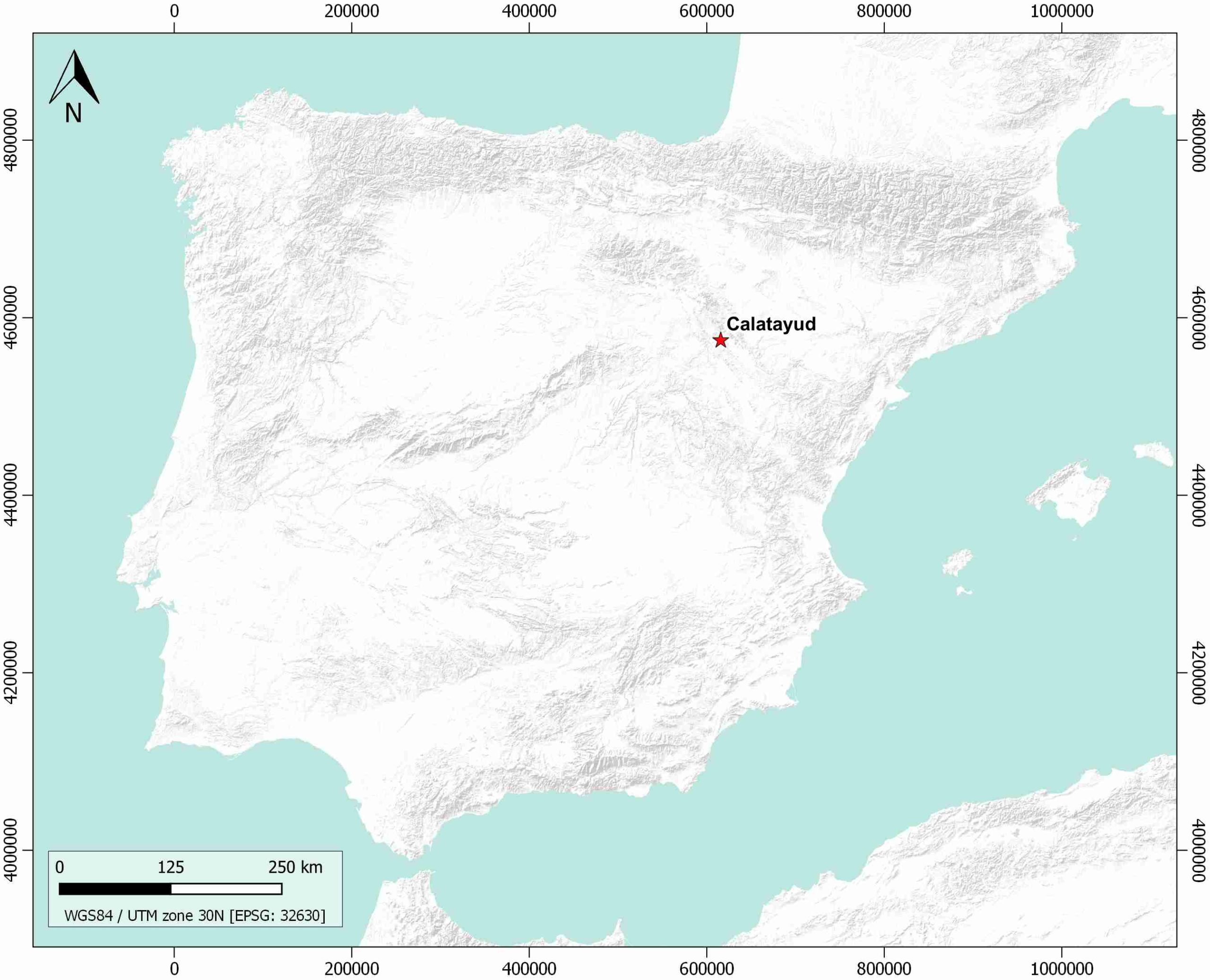
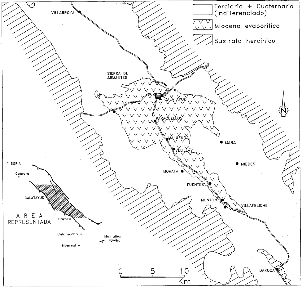
| Geological Setting | Calatayud Basin, Iberian Range |
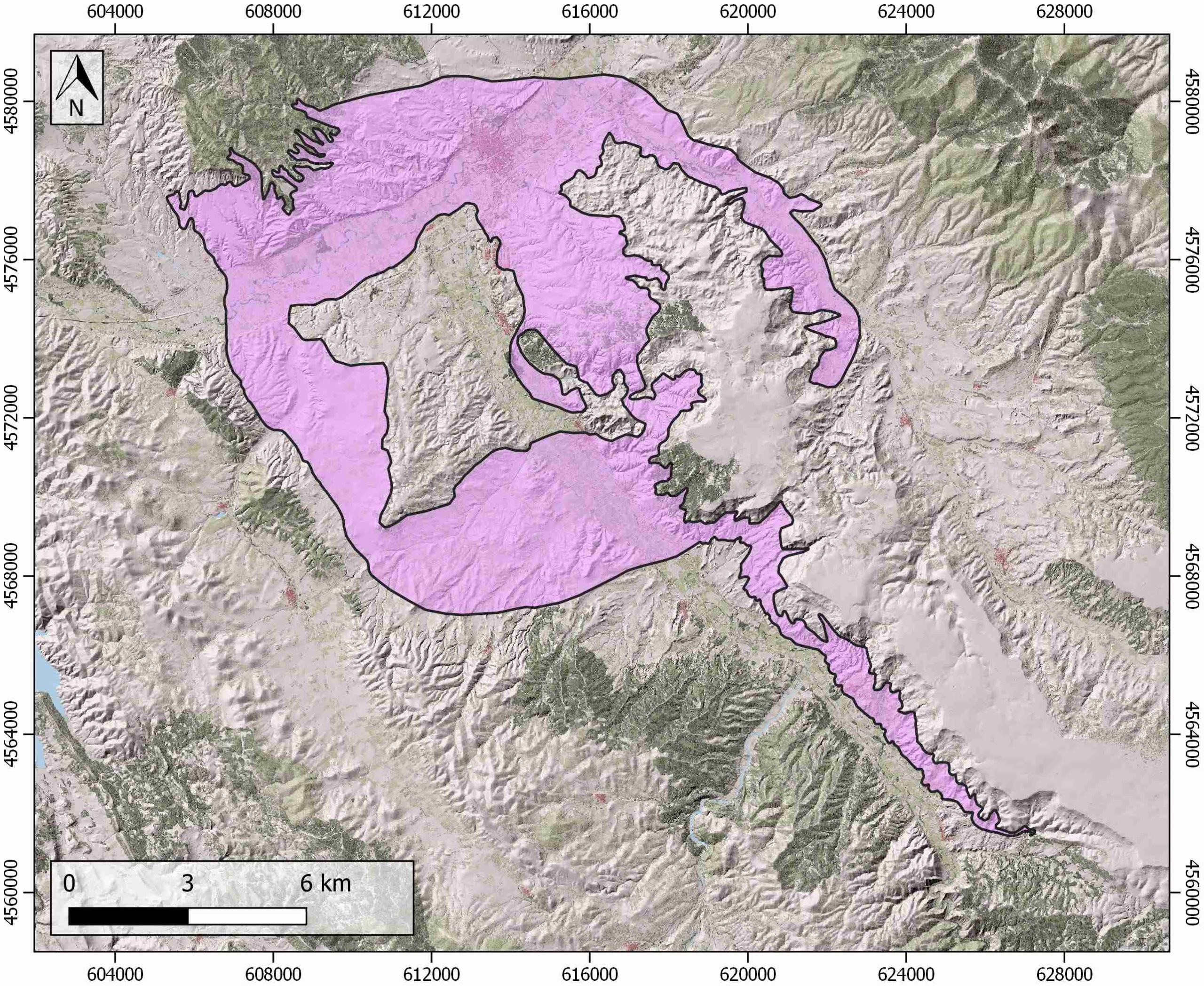
| Outcropping/buried | Outcropping |
| Evaporite unit/s name | Calatayud Gypsum Lower and Intermediate Units |
| Evaporite unit/s age | Lower-Middle Miocene |
| Evaporite unit/s origin | Continental |
| Classif. (Hudec and Jackson, 2009) | No diapirism |
| Classif. (Jackson and Talbot, 1986) | No diapirism |
| Age of evaporite flow or deformation (when deformed) | Undeformed |
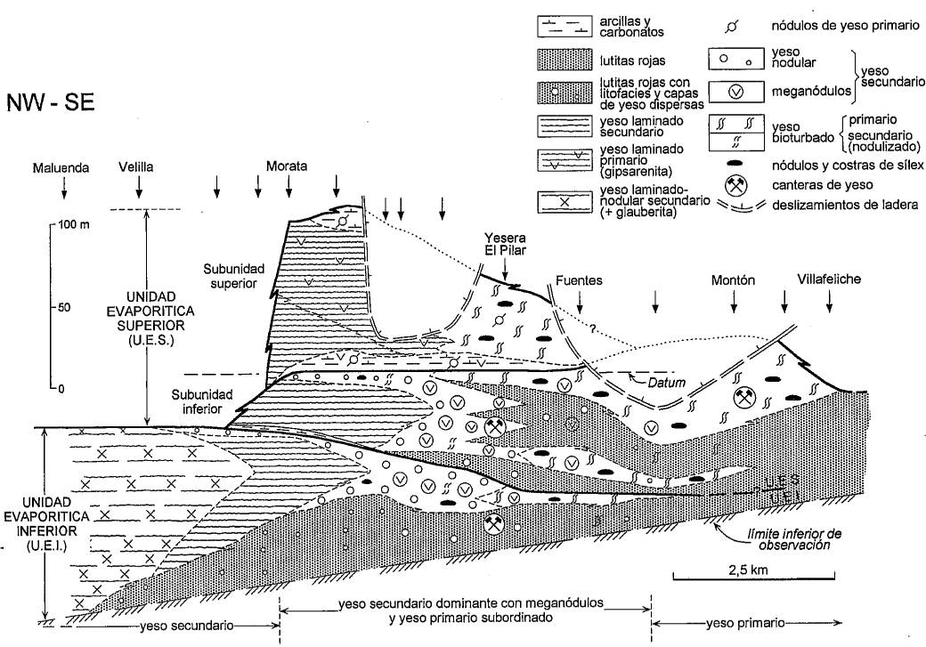
| Other comments | Hydration diapirism proposed by Hoyos et al. (1996) but discarded by Ortí and Rosell (2000). Sharp transition between the lower and upper evaporite units, attributed by Ortí and Rosell (2000) to the structural control in the evolution of the basin and/or to a climatic change to less arid conditions. |
Generic Data
| Unique ID | 125 |
| Name | Calatayud |
| Structure type | Evaporite body |
| Deformed/Undeformed | Undeformed |
| Buried/Outcropping | Outcropping |
| Geological setting | Iberian Range |
| Geological Regional Setting | Calatayud basin |
| Evaporite unit/s name | Calatayud Gypsum Lower and Intermediate Units |
| Evaporite unit/s age | Lower-Middle Miocene |
| Evaporite unit/s era | Cenozoic |
| Evaporite unit/s origin | Continental |
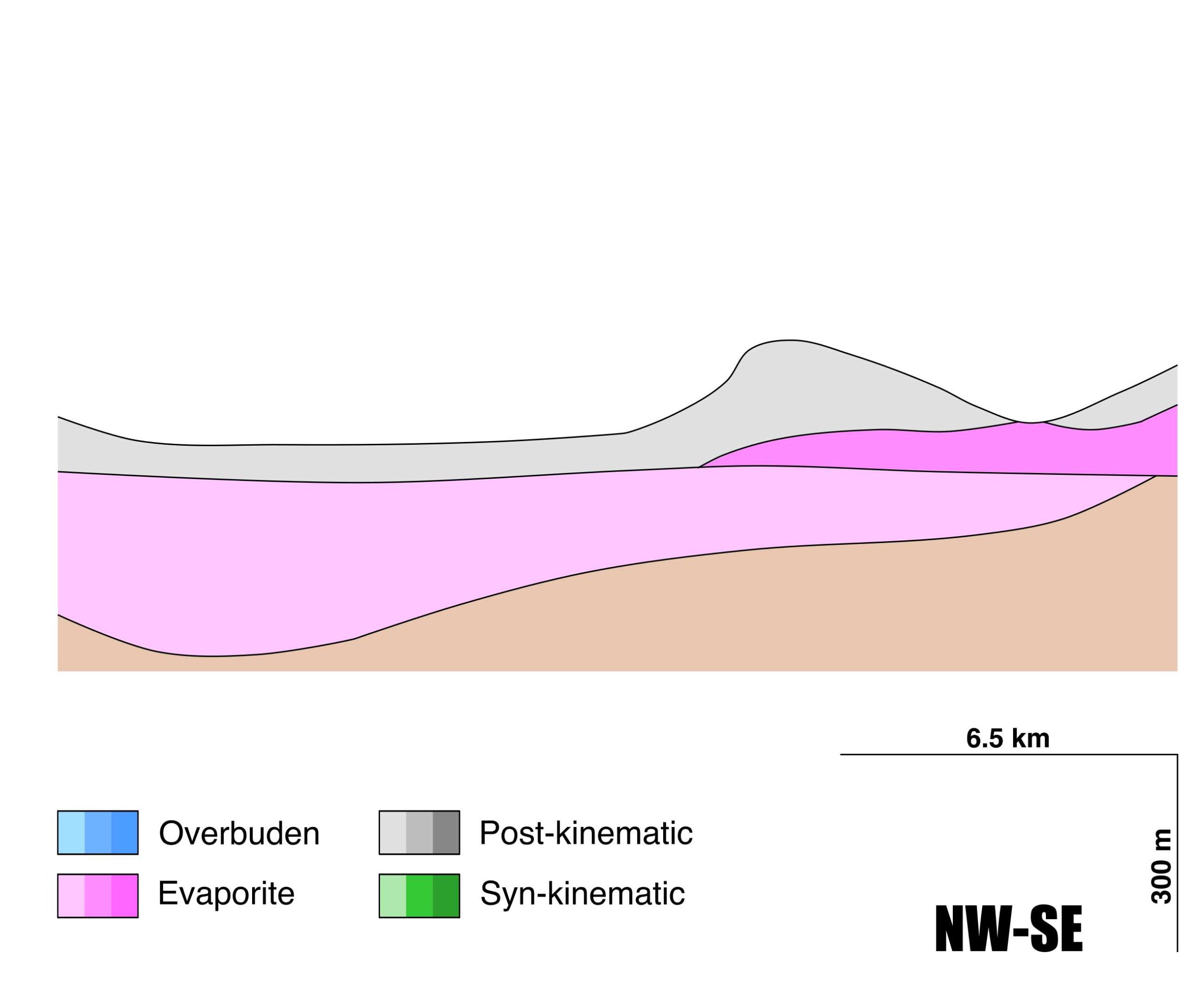
| Evaporite unit/s composition | Nodular to laminated gypsum-Laminated gypsiferous lutite-Bioturbated gypsum with associated nodules and meganodules-Carbonates-Marlstones-Sepiolite |
| Post-kinematic unit/s (or post-evaporite units when evaporites are undeformed) | Middle to Upper Miocene (Upper part of the Intermediate Unit, limestones and marlstones) ; Upper Miocene (Upper Unit, limestones, sandstones and shales) ; Quaternary (alluvial and colluvial detrital deposits) |
| Post-kinematic unit/s age (or post-evaporite units when evaporites are undeformed) | Middle Miocene-Holocene |
| Classification (Hudec and Jackson, 2009) | No diapirism |
| Classification (Jackson and Talbot, 1986) | No diapirism |
| Mining activity? | Y |
| Mining activity start | |
| Mining activity end | Active |
| Mining galleries? | N |
| Mining products | Gypsum |
| Mining sub-products | |
| Evaporite flow? | N |
| Age of evaporite flow | – |
| Flow or deformation triggering mechanisms | – |
| Flow-linked structures? | – |
| Halokinetic structures | – |
| Post-evaporite and pre-kinematic unit/s (overbuden) | – |
| Syn-kinematic unit/s | – |
| Available seismic profiles | |
| Available boreholes | V-08-2 / V-08-1 / FUENTES DE JILOCA / MALUENDA-1 (SINDICATO DE RIEGOS) / MALUENDA-2 / VILLALBA DE PEREJILES / CALATAYUD (MARIVELLA-CALATAYUD) |
| Additional comments | Hydration diapirism proposed by Hoyos et al. (1996) but discarded by Ortí and Rosell (2000). Sharp transition between the lower and upper evaporite units, attributed by Ortí and Rosell (2000) to structural control in the evolution of the basin and/or to a climatic change to less arid conditions |
Mining Data
| UNIQUE_ID | 125 |
| Minning exploitations within <2km? | Y |
| Historical/Active | Active |
| Exploitation name #1 | LA SOLEDAD |
| Exploitation ID (Spanish National Mining Cadastre) #1 | 2510 |
| Municipality #1 | Fuentes de Jiloca |
| Province #1 | ZARAGOZA |
| Company #1 | JILOCA STONE, S.A. |
| Main minning Products #1 | Gyupsum |
| Exploitation name #2 | JESUS DEL MONTE |
| Exploitation ID (Spanish National Mining Cadastre) #2 | 210 |
| Municipality #2 | Calatayud |
| Province #2 | ZARAGOZA |
| Company #2 | ARIDOS Y HORMIGONES CORTES, S.L |
| Main minning Products #2 | Gravel and sand |
| Exploitation name #3 | |
| Exploitation ID (Spanish National Mining Cadastre) #3 | |
| Municipality #3 | |
| Province #3 | |
| Company #3 | |
| Main minning Products #3 |
Quantitative Data
| UNIQUE_ID | 125 |
| Outcropping area (km2) | 110.46113 |
| Horizontal intersection area (km2) (when buried) | Not buried |
| Depth of intersection area (km2) (when buried) | Not buried |
| Max. Width (Km) | 23.7235493 |
| Max. Length (Km) | 15.5699691 |
| Max. Evaporites thickness (km) | 0.3 |
| Max. Deformation age (Ma) | – |
| Min. Deformation age (Ma) | – |
| Deformation stages | 0 |
Reference Data
| UNIQUE_ID | 125 |
| Section source | Ortí, F., Rosell, L., 1998. Unidades evaporíticas de la Cuenca de Calatayud (Mioceno inferior-medio, Zaragoza). Geogaceta, 23, 111-114. [link] |
| Well / Borehole availability #1 | n.a. |
| Well / Borehole availability #2 | n.a. |
| Available data (Stratigraphy) #1 | Ortí, F., Rosell, L., 2000. Evaporative systems and diagenetic patterns in the Calatayud Basin (Miocene, central Spain). Sedimentology, 47(3), 665-685. [link] |
| Available data (Stratigraphy) #2 | Aziz, H. A., Hilgen, F., Krijgsman, W., Sanz, E., Calvo, J. P., 2000. Astronomical forcing of sedimentary cycles in the middle to late Miocene continental Calatayud Basin (NE Spain). Earth and Planetary Science Letters, 177(1-2), 9-22. [link] |
| Available data (Stratigraphy) #3 | Aziz, H. A., Sanz‐Rubio, E., Calvo, J. P., Hilgen, F. J., Krijgsman, W., 2003. Palaeoenvironmental reconstruction of a middle Miocene alluvial fan to cyclic shallow lacustrine depositional system in the Calatayud Basin (NE Spain). Sedimentology, 50(2), 211-236. [link] |
| Available data (Stratigraphy) #4 | Sanz Rubio, E., Rodríguez Aranda, J. P., Calvo Sorando, J. P., 2002. Petrología y geoquímica isotópica de los depósitos de magnesita de la cuenca de Calatayud (provincia de Zaragoza). Interpretación paleoambiental. Revista de la Sociedad Geológica de España, 15(1-2), 113-127. [link] |
| Available data (Stratigraphy) #5 | Sanz-Rubio, E., Sánchez-Moral, S., Cañaveras, J. C., Abdul-Aziz, H., Calvo Sorando, J. P., Cuezva, S., …, Van Dam, J., 2003. Síntesis de la cronoestratigrafía y evolución sedimentaria de los sistemas lacustres evaporíticos y carbonatados neógenos de la Cuenca de Calatayud-Montalbán. Estudios Geológicos, 59(1-4), 83-105. [link] |
| Available data (Stratigraphy) #6 | Ortí, F., Rosell, L., 1998. Unidades evaporíticas de la Cuenca de Calatayud (Mioceno inferior-medio, Zaragoza). Geogaceta, 23, 111-114. [link] |
| Regional Stratigraphy | Ortí, F., Rosell, L., 1998. Unidades evaporíticas de la Cuenca de Calatayud (Mioceno inferior-medio, Zaragoza). Geogaceta, 23, 111-114. [link] |
| Seismic data availability #1 | n.a. |
| Seismic data availability #2 | n.a. |
| Seismic data availability #3 | n.a. |
| Available data (Structure) #1 | Gutiérrez, F., 1996. Gypsum karstification induced subsidence: effects on alluvial systems and derived geohazards (Calatayud Graben, Iberian Range, Spain). Geomorphology, 16(4), 277-293. [link] |
| Available data (Structure) #2 | Casas, A. M., Casas, A., Pérez, A., Tena, S., Barrier, L., Gapais, D., Nalpas, T., 2000. Syn-tectonic sedimentation and thrust-and-fold kinematics at the intra-mountain Montalbán Basin (northern Iberian Chain, Spain). Geodinamica Acta, 13(1), 1-17. [link] |
| Available data (Structure) #3 | Sanz Rubio, E., Hoyos, M., Cañaveras, J. C., Sánchez Moral, S., 1995. Estructuras pseudoanticlinales inducidas por fluidificación en la Unidad Intermedia de la cuenca de Calatayud. Geogaceta, 18, 59-62. [link] |
| Available data (Structure) #4 | Sanz-Rubio, E., Sánchez-Moral, S., Cañaveras, J. C., Calvo, J. P., Rouchy, J. M., 2001. Calcitization of Mg–Ca carbonate and Ca sulphate deposits in a continental Tertiary basin (Calatayud Basin, NE Spain). Sedimentary Geology, 140(1-2), 123-142. [link] |
| Available data (Structure) #5 | Hoyos, M., Doblas, M., Sánchez-Moral, S., Cañaveras, J. C., Ordoñez, S., Sesé, C., …, Mahecha, V., 1996. Hydration diapirism: a climate-related initiation of evaporite mounds in two continental Neogene basins of central Spain. Geological Society, London, Special Publications, 100(1), 49-63. [link] |
| Available data (Structure) #6 | n.a. |
| Available data (Analogue modelling) #1 | n.a. |
| Available data (Analogue modelling) #2 | n.a. |
| Available data (Analogue modelling) #3 | n.a. |
| Available data (Gravimetry – Tomography) #1 | Casas, A. M., Casas, A., Pérez, A., Tena, S., Barrier, L., Gapais, D., Nalpas, T., 2000. Syn-tectonic sedimentation and thrust-and-fold kinematics at the intra-mountain Montalbán Basin (northern Iberian Chain, Spain). Geodinamica Acta, 13(1), 1-17. [link] |
| Available data (Gravimetry – Tomography) #2 | Ayala, C., Bohoyo, F., Maestro, A., Reguera, M. I., Torne, M., Rubio, F., Fernández, M., García-Lobón, J. L., 2016. Updated Bouguer anomalies of the Iberian Peninsula: a new perspective to interpret the regional geology. Journal of Maps, 12(5), 1089-1092. [link] |
| Available data (Gravimetry – Tomography) #3 | n.a. |
| Available data (Geochemistry) #1 | Sanz Rubio, E., Rodríguez Aranda, J. P., Calvo Sorando, J. P., 2002. Petrología y geoquímica isotópica de los depósitos de magnesita de la cuenca de Calatayud (provincia de Zaragoza). Interpretación paleoambiental. Revista de la Sociedad Geológica de España, 15(1-2), 113-127. [link] |
| Available data (Geochemistry) #2 | Aziz, H. A., Sanz‐Rubio, E., Calvo, J. P., Hilgen, F. J., Krijgsman, W., 2003. Palaeoenvironmental reconstruction of a middle Miocene alluvial fan to cyclic shallow lacustrine depositional system in the Calatayud Basin (NE Spain). Sedimentology, 50(2), 211-236. [link] |
| Available data (Geochemistry) #3 | Ortí, F., Rosell, L., Fallick, A. E., Utrilla, R., 1994. Yesos de Calatayud: Aplicación del estudio de facies y geoquímica de sulfatos al conocimiento de un sistema evaporítico. Geogaceta, 15, 74-77. [link] |
| Available data (Geochemistry) #4 | Sanz-Rubio, E., Sánchez-Moral, S., Cañaveras, J. C., Calvo, J. P., Rouchy, J. M., 2001. Calcitization of Mg–Ca carbonate and Ca sulphate deposits in a continental Tertiary basin (Calatayud Basin, NE Spain). Sedimentary Geology, 140(1-2), 123-142. [link] |
| Available data (Petrophysics) #1 | Aziz, H. A., Hilgen, F., Krijgsman, W., Sanz, E., Calvo, J. P., 2000. Astronomical forcing of sedimentary cycles in the middle to late Miocene continental Calatayud Basin (NE Spain). Earth and Planetary Science Letters, 177(1-2), 9-22. [link] |
| Available data (Petrophysics) #2 | n.a. |
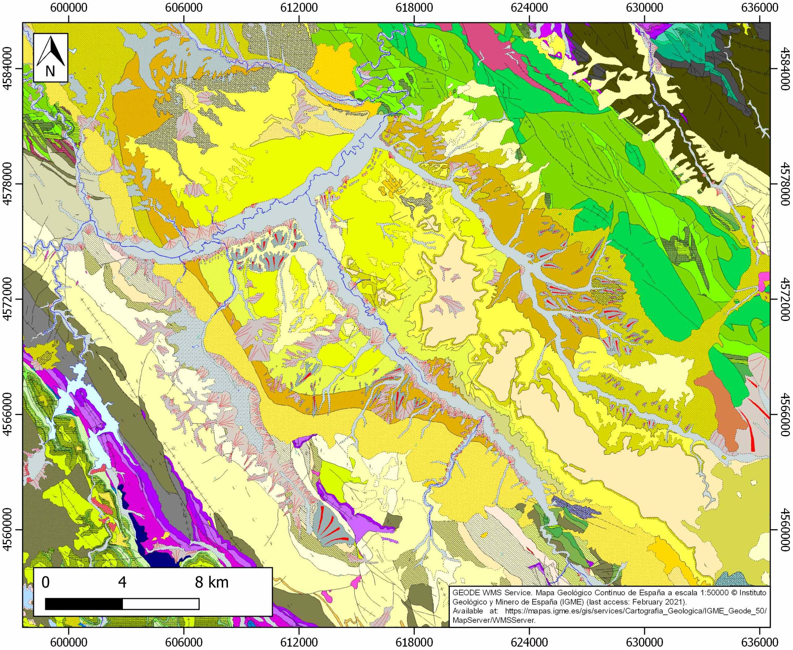
| IGME Geological Map (MAGNA50) Sheet number | 409-Calatayud. [link] and 437-Ateca. [link] |
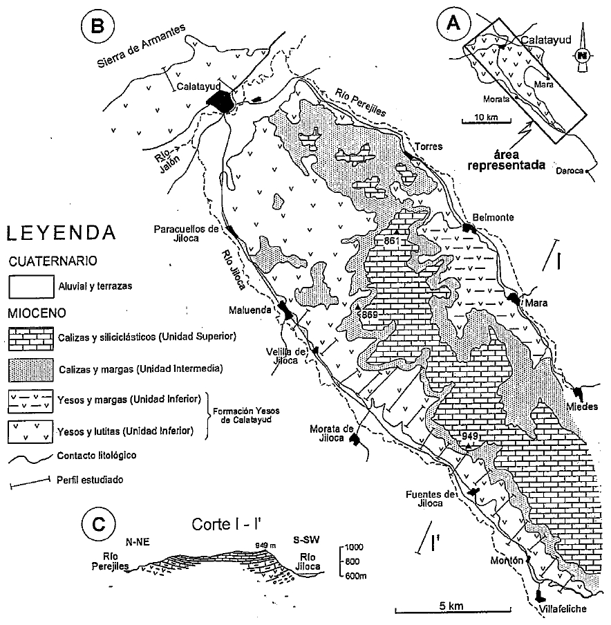
| Other Maps #1 (source) | Ortí, F., Rosell, L., Fallick, A. E., Utrilla, R., 1994. Yesos de Calatayud: Aplicación del estudio de facies y geoquímica de sulfatos al conocimiento de un sistema evaporítico. Geogaceta, 15, 74-77. [link] |
| Other Maps #2 (source) | Ortí, F., Rosell, L., 1998. Unidades evaporíticas de la Cuenca de Calatayud (Mioceno inferior-medio, Zaragoza). Geogaceta, 23, 111-114. [link] |
| Other related references #1 | Ortí, F., Rosell, L., Salvany, J. M., Inglès, M., 1997. Chert in continental evaporites of the Ebro and Calatayud basins (Spain): distribution and significance. Siliceous Rocks and Culture. Universidad de Granada, Monográfica Arte y Arqueología, 42, 75-89. [link] |
| Other related references #2 | Gutiérrez, F., Cooper, A. H., 2002. Evaporite dissolution subsidence in the historical city of Calatayud, Spain: damage appraisal and prevention. Natural Hazards, 25(3), 259-288. [link] |
| Other related references #3 | n.a. |
| Other related references #4 | n.a. |
Well and Seismic Data
| UNIQUE_ID | 125 |
| Seismic survey name #1 | |
| Across structure? #1 | |
| Seismic profile ID (IGME) #1 | |
| Seismic profile code #1 | |
| Seismic profile name #1 | |
| Seismic survey year #1 | |
| Data repository #1 | |
| Length (km) #1 | |
| Seismic survey name #2 | |
| Across structure? #2 | |
| Seismic profile ID (IGME) #2 | |
| Seismic profile code #2 | |
| Seismic profile name #2 | |
| Seismic survey year #2 | |
| Data repository #2 | |
| Length (km) #2 | |
| Seismic survey name #3 | |
| Across structure? #3 | |
| Seismic profile ID (IGME) #3 | |
| Seismic profile code #3 | |
| Seismic profile name #3 | |
| Seismic survey year #3 | |
| Data repository #3 | |
| Length (km) #3 | |
| Seismic survey name #4 | |
| Across structure? #4 | |
| Seismic profile ID (IGME) #4 | |
| Seismic profile code #4 | |
| Seismic profile name #4 | |
| Seismic survey year #4 | |
| Data repository #4 | |
| Length (km) #4 | |
| Seismic survey name #5 | |
| Across structure? #5 | |
| Seismic profile ID (IGME) #5 | |
| Seismic profile code #5 | |
| Seismic profile name #5 | |
| Seismic survey year #5 | |
| Data repository #5 | |
| Length (km) #5 | |
| Seismic survey name #6 | |
| Across structure? #6 | |
| Seismic profile ID (IGME) #6 | |
| Seismic profile code #6 | |
| Seismic profile name #6 | |
| Seismic survey year #6 | |
| Data repository #6 | |
| Length (km) #6 | |
| Seismic survey name #7 | |
| Across structure? #7 | |
| Seismic profile ID (IGME) #7 | |
| Seismic profile code #7 | |
| Seismic profile name #7 | |
| Seismic survey year #7 | |
| Data repository #7 | |
| Length (km) #7 | |
| Seismic survey name #8 | |
| Across structure? #8 | |
| Seismic profile ID (IGME) #8 | |
| Seismic profile code #8 | |
| Seismic profile name #8 | |
| Seismic survey year #8 | |
| Data repository #8 | |
| Length (km) #8 | |
| Seismic survey name #9 | |
| Across structure? #9 | |
| Seismic profile ID (IGME) #9 | |
| Seismic profile code #9 | |
| Seismic profile name #9 | |
| Seismic survey year #9 | |
| Data repository #9 | |
| Length (km) #9 | |
| Seismic survey name #10 | |
| Across structure? #10 | |
| Seismic profile ID (IGME) #10 | |
| Seismic profile code #10 | |
| Seismic profile name #10 | |
| Seismic survey year #10 | |
| Data repository #10 | |
| Length (km) #10 | |
| Seismic survey name #11 | |
| Across structure? #11 | |
| Seismic profile ID (IGME) #11 | |
| Seismic profile code #11 | |
| Seismic profile name #11 | |
| Seismic survey year #11 | |
| Data repository #11 | |
| Length (km) #11 | |
| Seismic survey name #12 | |
| Across structure? #12 | |
| Seismic profile ID (IGME) #12 | |
| Seismic profile code #12 | |
| Seismic profile name #12 | |
| Seismic survey year #12 | |
| Data repository #12 | |
| Length (km) #12 | |
| Seismic survey name #13 | |
| Across structure? #13 | |
| Seismic profile ID (IGME) #13 | |
| Seismic profile code #13 | |
| Seismic profile name #13 | |
| Seismic survey year #13 | |
| Data repository #13 | |
| Length (km) #13 | |
| Seismic survey name #14 | |
| Across structure? #14 | |
| Seismic profile ID (IGME) #14 | |
| Seismic profile code #14 | |
| Seismic profile name #14 | |
| Seismic survey year #14 | |
| Data repository #14 | |
| Length (km) #14 | |
| Seismic survey name #15 | |
| Across structure? #15 | |
| Seismic profile ID (IGME) #15 | |
| Seismic profile code #15 | |
| Seismic profile name #15 | |
| Seismic survey year #15 | |
| Data repository #15 | |
| Length (km) #15 | |
| Seismic survey name #16 | |
| Across structure? #16 | |
| Seismic profile ID (IGME) #16 | |
| Seismic profile code #16 | |
| Seismic profile name #16 | |
| Seismic survey year #16 | |
| Data repository #16 | |
| Length (km) #16 | |
| Seismic survey name #17 | |
| Across structure? #17 | |
| Seismic profile ID (IGME) #17 | |
| Seismic profile code #17 | |
| Seismic profile name #17 | |
| Seismic survey year #17 | |
| Data repository #17 | |
| Length (km) #17 | |
| Seismic survey name #18 | |
| Across structure? #18 | |
| Seismic profile ID (IGME) #18 | |
| Seismic profile code #18 | |
| Seismic profile name #18 | |
| Seismic survey year #18 | |
| Data repository #18 | |
| Length (km) #18 | |
| Seismic survey name #19 | |
| Across structure? #19 | |
| Seismic profile ID (IGME) #19 | |
| Seismic profile code #19 | |
| Seismic profile name #19 | |
| Seismic survey year #19 | |
| Data repository #19 | |
| Length (km) #19 | |
| Seismic survey name #20 | |
| Across structure? #20 | |
| Seismic profile ID (IGME) #20 | |
| Seismic profile code #20 | |
| Seismic profile name #20 | |
| Seismic survey year #20 | |
| Data repository #20 | |
| Length (km) #20 | |
| Seismic survey name #21 | |
| Across structure? #21 | |
| Seismic profile ID (IGME) #21 | |
| Seismic profile code #21 | |
| Seismic profile name #21 | |
| Seismic survey year #21 | |
| Data repository #21 | |
| Length (km) #21 | |
| Borehole name #1 | V-08-2 |
| Company #1 | ADARO |
| Traget #1 | GYPSUM |
| Across structure? #1 | Y |
| Borehole name #2 | V-08-1 |
| Company #2 | ADARO |
| Traget #2 | GYPSUM |
| Across structure? #2 | Y |
| Borehole name #3 | FUENTES DE JILOCA |
| Company #3 | CONFEDERACION HIDROGRAFICA DEL EBRO |
| Traget #3 | HYDROGEOLOGY |
| Across structure? #3 | Y |
| Borehole name #4 | MALUENDA-1 (SINDICATO DE RIEGOS) |
| Company #4 | TRAGSA |
| Traget #4 | HYDROGEOLOGY |
| Across structure? #4 | Y |
| Borehole name #5 | MALUENDA-2 |
| Company #5 | TRAGSA |
| Traget #5 | HYDROGEOLOGY |
| Across structure? #5 | Y |
| Borehole name #6 | VILLALBA DE PEREJILES |
| Company #6 | CONFEDERACION HIDROGRAFICA DEL EBRO |
| Traget #6 | HYDROGEOLOGY |
| Across structure? #6 | N (within 5 km) |
| Borehole name #7 | CALATAYUD (MARIVELLA-CALATAYUD) |
| Company #7 | CONFEDERACION HIDROGRAFICA DEL EBRO |
| Traget #7 | HYDROGEOLOGY |
| Across structure? #7 | N (within 5 km) |
| Borehole name #8 | |
| Company #8 | |
| Traget #8 | |
| Across structure? #8 | |
| Borehole name #9 | |
| Company #9 | |
| Traget #9 | |
| Across structure? #9 | |
| Borehole name #10 | |
| Company #10 | |
| Traget #10 | |
| Across structure? #10 | |
| Borehole name #11 | |
| Company #11 | |
| Traget #11 | |
| Across structure? #11 | |
| Borehole name #12 | |
| Company #12 | |
| Traget #12 | |
| Across structure? #12 | |
| Borehole name #13 | |
| Company #13 | |
| Traget #13 | |
| Across structure? #13 | |
| Borehole name #14 | |
| Company #14 | |
| Traget #14 | |
| Across structure? #14 | |
| Borehole name #15 | |
| Company #15 | |
| Traget #15 | |
| Across structure? #15 |
Geographical Data (EPSG:4326 - WGS 84)
| UNIQUE_ID | 125 |
| X Centroid (Structure shape) | -1.637358 |
| Y Centroid (Structure shape) | -1.637358 |
| Xmin (Structure shape) | -1.741348 |
| Xmax (Structure shape) | -1.482353 |
| Ymin (Structure shape) | 41.194267 |
| Ymax (Structure shape) | 41.369401 |
| Xmin seismic line #1 | |
| Xmax seismic line #1 | |
| Ymin seismic line #1 | |
| Ymax seismic line #1 | |
| Xmin seismic line #2 | |
| Xmax seismic line #2 | |
| Ymin seismic line #2 | |
| Ymax seismic line #2 | |
| Xmin seismic line #3 | |
| Xmax seismic line #3 | |
| Ymin seismic line #3 | |
| Ymax seismic line #3 | |
| Xmin seismic line #4 | |
| Xmax seismic line #4 | |
| Ymin seismic line #4 | |
| Ymax seismic line #4 | |
| Xmin seismic line #5 | |
| Xmax seismic line #5 | |
| Ymin seismic line #5 | |
| Ymax seismic line #5 | |
| Xmin seismic line #6 | |
| Xmax seismic line #6 | |
| Ymin seismic line #6 | |
| Ymax seismic line #6 | |
| Xmin seismic line #7 | |
| Xmax seismic line #7 | |
| Ymin seismic line #7 | |
| Ymax seismic line #7 | |
| Xmin seismic line #8 | |
| Xmax seismic line #8 | |
| Ymin seismic line #8 | |
| Ymax seismic line #8 | |
| Xmin seismic line #9 | |
| Xmax seismic line #9 | |
| Ymin seismic line #9 | |
| Ymax seismic line #9 | |
| Xmin seismic line #10 | |
| Xmax seismic line #10 | |
| Ymin seismic line #10 | |
| Ymax seismic line #10 | |
| Xmin seismic line #11 | |
| Xmax seismic line #11 | |
| Ymin seismic line #11 | |
| Ymax seismic line #11 | |
| Xmin seismic line #12 | |
| Xmax seismic line #12 | |
| Ymin seismic line #12 | |
| Ymax seismic line #12 | |
| Xmin seismic line #13 | |
| Xmax seismic line #13 | |
| Ymin seismic line #13 | |
| Ymax seismic line #13 | |
| Xmin seismic line #14 | |
| Xmax seismic line #14 | |
| Ymin seismic line #14 | |
| Ymax seismic line #14 | |
| Xmin seismic line #15 | |
| Xmax seismic line #15 | |
| Ymin seismic line #15 | |
| Ymax seismic line #15 | |
| Xmin seismic line #16 | |
| Xmax seismic line #16 | |
| Ymin seismic line #16 | |
| Ymax seismic line #16 | |
| Xmin seismic line #17 | |
| Xmax seismic line #17 | |
| Ymin seismic line #17 | |
| Ymax seismic line #17 | |
| Xmin seismic line #18 | |
| Xmax seismic line #18 | |
| Ymin seismic line #18 | |
| Ymax seismic line #18 | |
| Xmin seismic line #19 | |
| Xmax seismic line #19 | |
| Ymin seismic line #19 | |
| Ymax seismic line #19 | |
| Xmin seismic line #20 | |
| Xmax seismic line #20 | |
| Ymin seismic line #20 | |
| Ymax seismic line #20 | |
| Xmin seismic line #21 | |
| Xmax seismic line #21 | |
| Ymin seismic line #21 | |
| Ymax seismic line #21 | |
| X borehole #1 | -1.539509 |
| Y borehole #1 | 41.236611 |
| X borehole #2 | -1.620901 |
| Y borehole #2 | 41.329662 |
| X borehole #3 | -1.534438 |
| Y borehole #3 | 41.224828 |
| X borehole #4 | -1.615761 |
| Y borehole #4 | 41.274375 |
| X borehole #5 | -1.619929 |
| Y borehole #5 | 41.274335 |
| X borehole #6 | -1.547909 |
| Y borehole #6 | 41.343248 |
| X borehole #7 | -1.585313 |
| Y borehole #7 | 41.362872 |
| X borehole #8 | |
| Y borehole #8 | |
| X borehole #9 | |
| Y borehole #9 | |
| X borehole #10 | |
| Y borehole #10 | |
| X borehole #11 | |
| Y borehole #11 | |
| X borehole #12 | |
| Y borehole #12 | |
| X borehole #13 | |
| Y borehole #13 | |
| X borehole #14 | |
| Y borehole #14 | |
| X borehole #15 | |
| Y borehole #15 |

