General Information
| Structure type | Evaporite body |
| Deformed/Undeformed | Deformed |
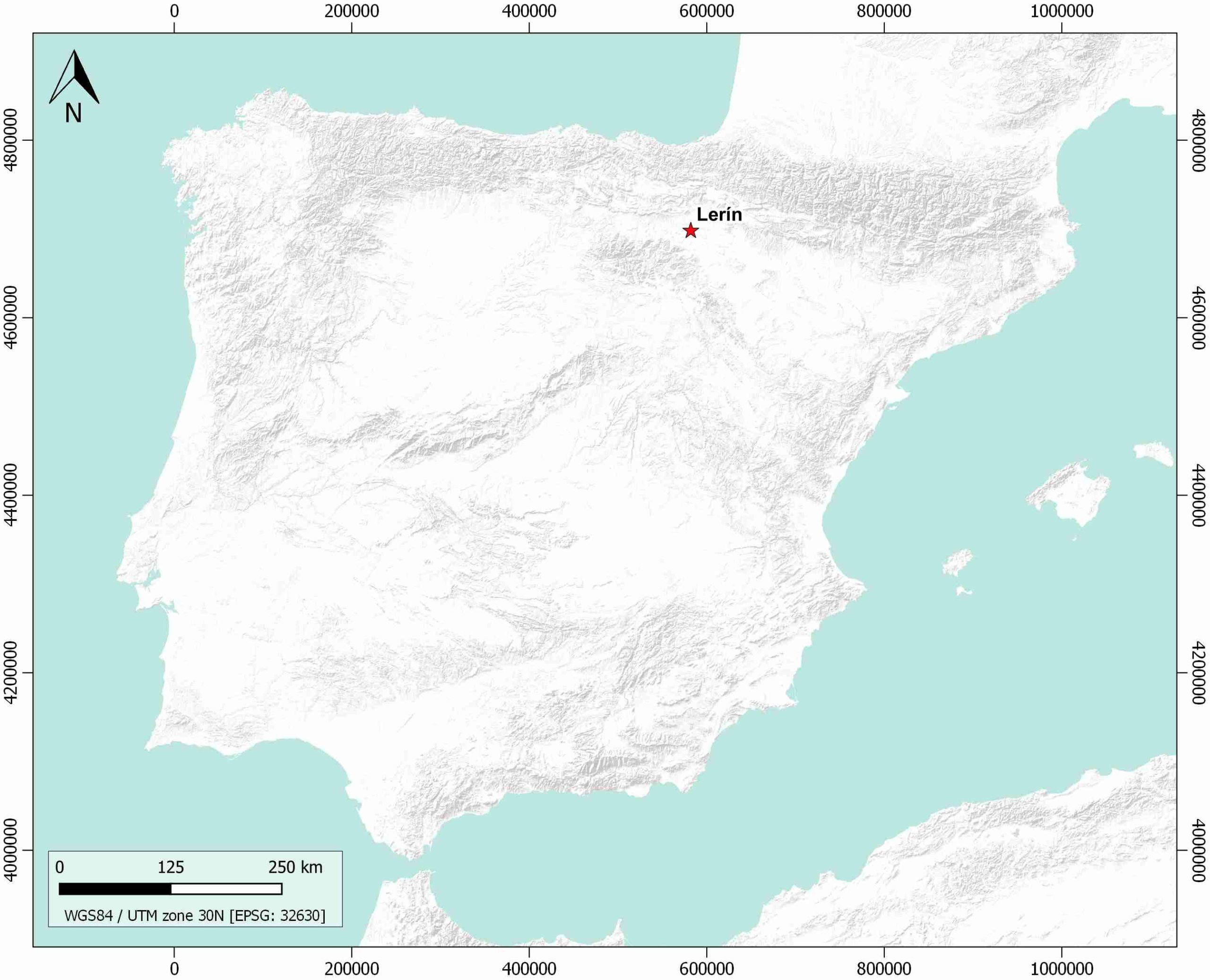
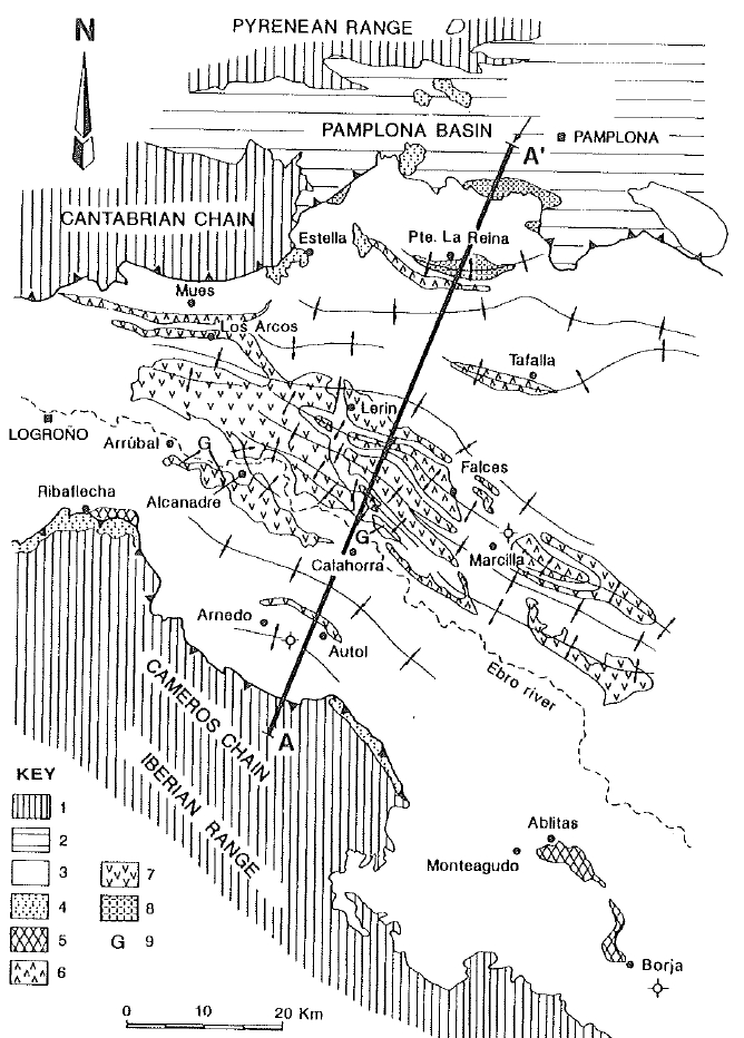
| Geological Setting | Ebro foreland basin, Northwestern Domain |
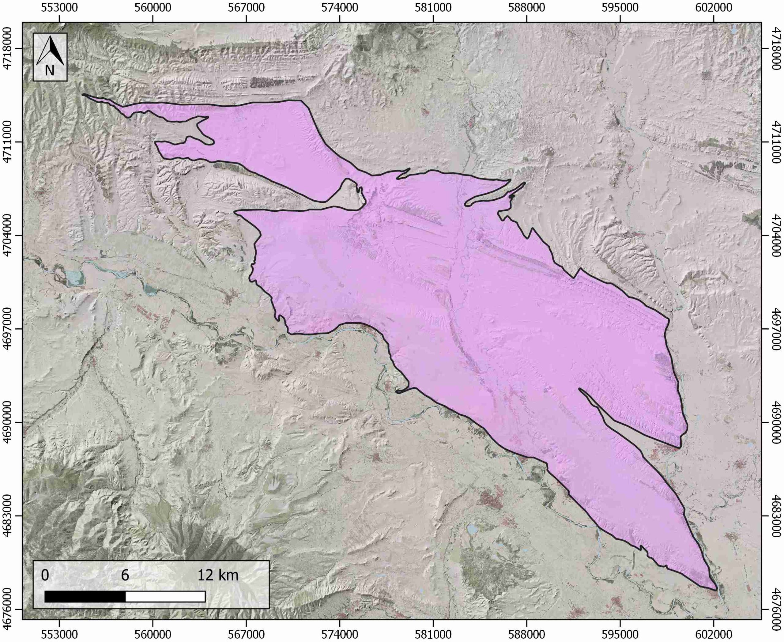
| Outcropping/buried | Outcropping |
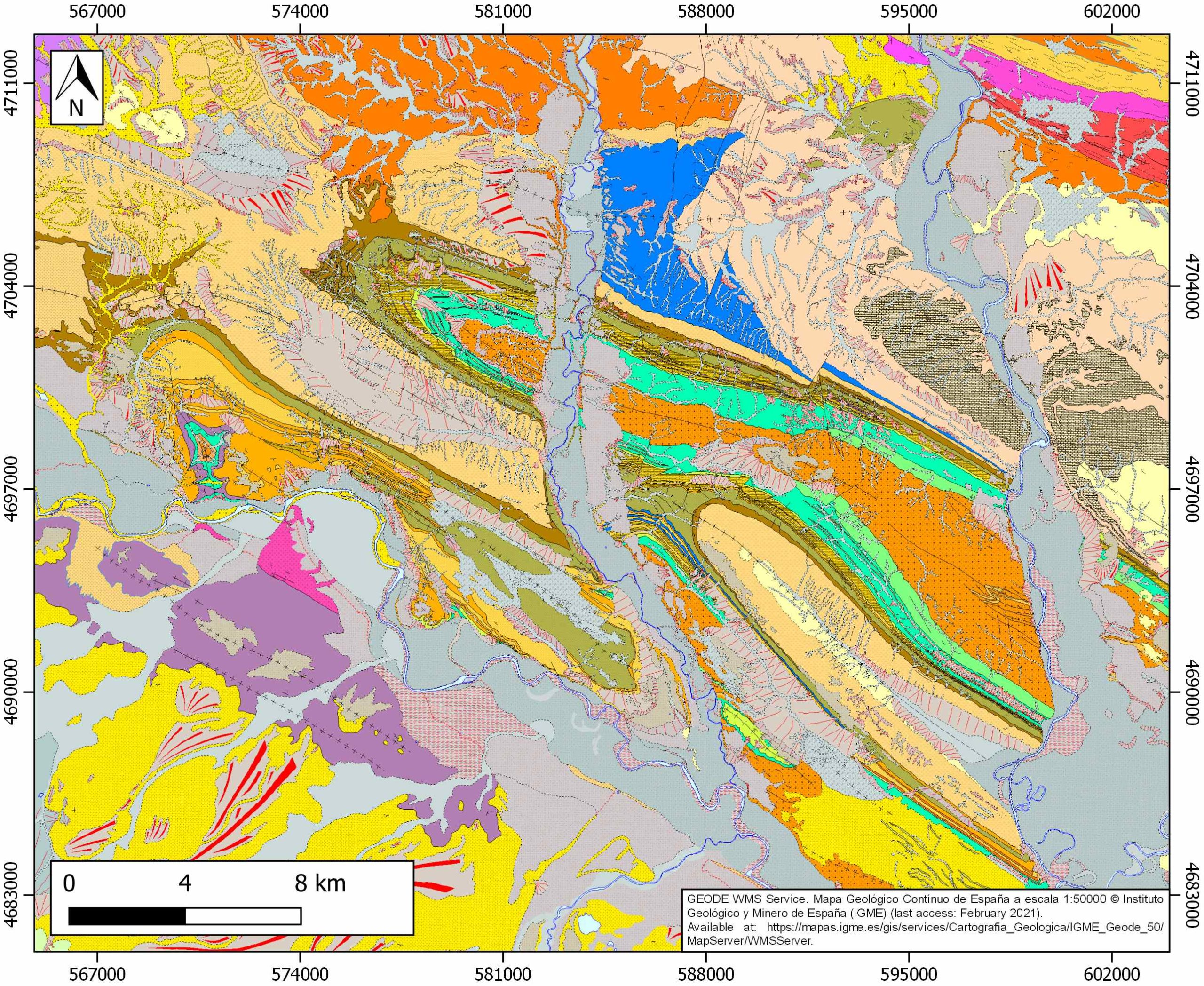
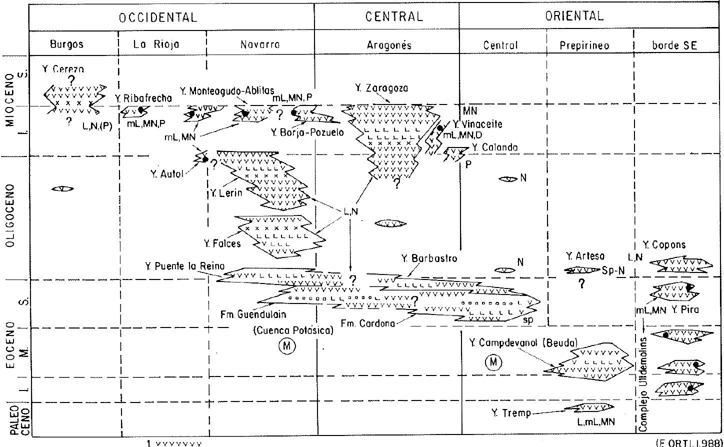
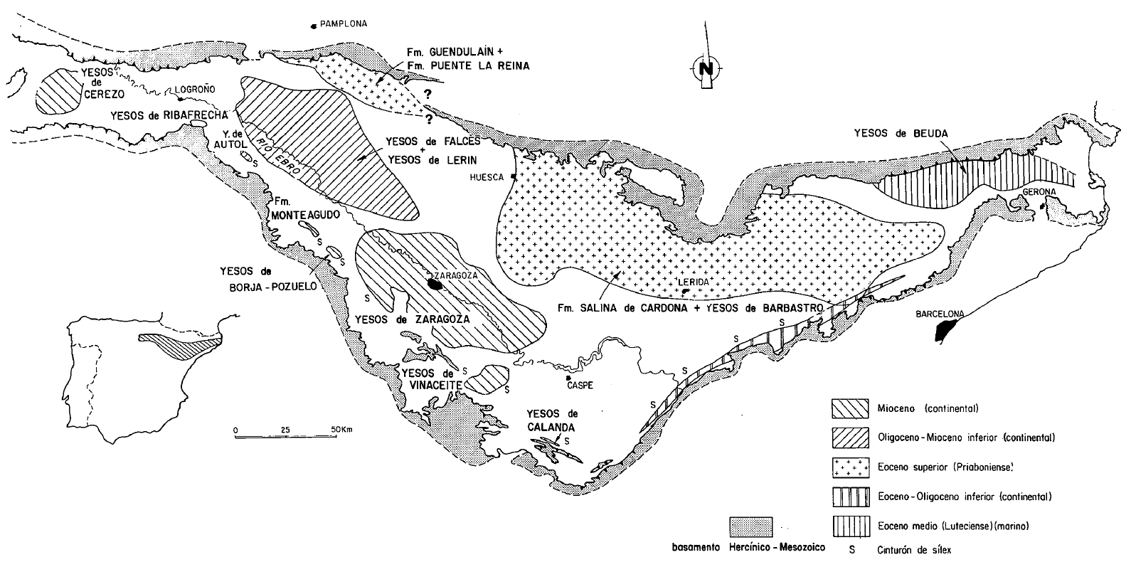
| Evaporite unit/s name | Falces gypsum Fm., Lerín gypsum Fm., Los Arcos gypsum Unit |
| Evaporite unit/s age | Oligocene-Lower Miocene |
| Evaporite unit/s origin | Continental |
| Classif. (Hudec and Jackson, 2009) | No diapirism |
| Classif. (Jackson and Talbot, 1986) | No diapirism |
| Age of evaporite flow or deformation (when deformed) | Miocene |
| Other comments | Los Arcos gypsum Unit represents the uppermost level of the Lerín Fm., and contains widely studied glauberite deposits. |
Generic Data
| Unique ID | 130 |
| Name | Lerín |
| Structure type | Evaporite body |
| Deformed/Undeformed | Deformed |
| Buried/Outcropping | Outcropping |
| Geological setting | Southern Pyrenees |
| Geological Regional Setting | Buerba Corridor |
| Evaporite unit/s name | Falces gypsum Fm., Lerín Gypsum Fm. Amd Los Arcos gypsum unit |
| Evaporite unit/s age | Oligocene-Lower Miocene |
| Evaporite unit/s era | Cenozoic |
| Evaporite unit/s origin | Continental |
| Evaporite unit/s composition | Gypsum-Shale-Anhydrite-Glauberite-Halite-Sandstone |
| Post-kinematic unit/s (or post-evaporite units when evaporites are undeformed) | Middle-Upper Miocene (limestones, sandstones and conglomerates) ; Quaternary (alluvial and colluvial detrital deposits) |
| Post-kinematic unit/s age (or post-evaporite units when evaporites are undeformed) | Middle Miocene-Holocene |
| Classification (Hudec and Jackson, 2009) | No diapirism |
| Classification (Jackson and Talbot, 1986) | No diapirism |
| Mining activity? | Y |
| Mining activity start | |
| Mining activity end | Active |
| Mining galleries? | N |
| Mining products | Gravel and sand |
| Mining sub-products | |
| Evaporite flow? | Y |
| Age of evaporite flow | Lower Miocene (early stage) and Middle Miocene (late stage) |
| Flow or deformation triggering mechanisms | Miocene (Alpine) compression in the Navarra-Rioja basin (folding during the early stage and thrust emplacement during the late stage) |
| Flow-linked structures? | Y |
| Halokinetic structures | Thrust faults / anticline-syncline folding / Low-angle unconformities |
| Post-evaporite and pre-kinematic unit/s (overbuden) | – |
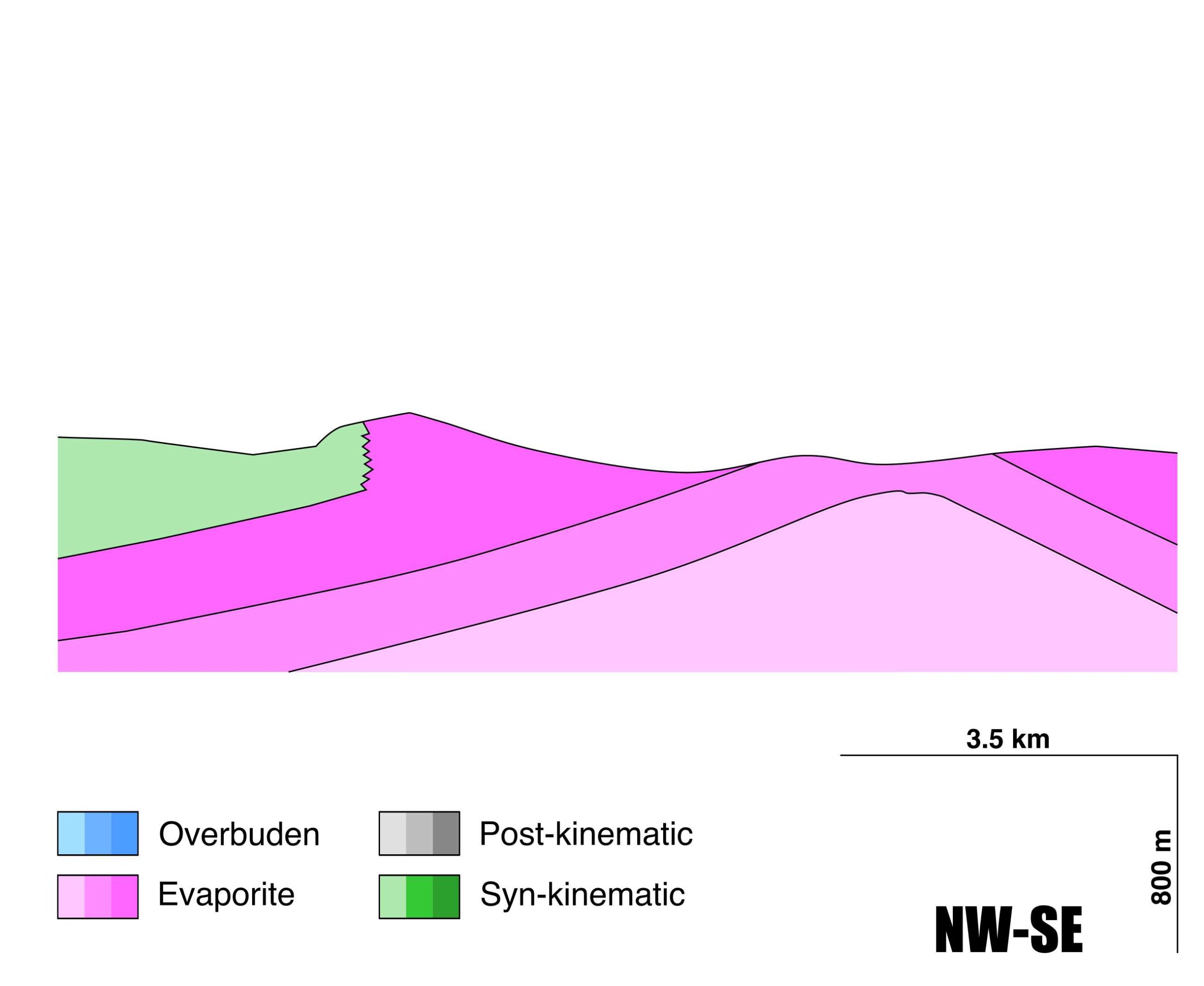
| Syn-kinematic unit/s | Lower Miocene (Tudela Fm., shales and sandstones) ; Lower-Middle Miocene (Alfaro Fm., sandstones) |
| Available seismic profiles | RI-43 / RI-37 / ELZ-13 / ELZ-12 / RI-35 / LO-10 / LO-3 / LO-07 / LO-15 / LO-04 / LO-7 / LO-4 / RI-44 / RI-40 / RI-36-BIS / ELZ-84-09 / RI-39 / LO-15 / RI-6-BIS / ELZ-11 / LN-2 |
| Available boreholes | V-05-3 / V-05-4 / V-05-1 / V-05-2 / V-05-5 / RINCON DE SOTO (RINCON) / CALAHORRA |
| Additional comments | Los Arcos gypsum Unit represents the uppermost level of the Lerín Fm., and contains widely studied glauberite deposits |
Mining Data
| UNIQUE_ID | 130 |
| Minning exploitations within <2km? | Y |
| Historical/Active | Active |
| Exploitation name #1 | VICUÑA I |
| Exploitation ID (Spanish National Mining Cadastre) #1 | 22334 |
| Municipality #1 | Andosilla |
| Province #1 | NAVARRA |
| Company #1 | ÁRIDOS Y EXCAVACIONES VICUÑA, S.L. |
| Main minning Products #1 | Gravel and sand |
| Exploitation name #2 | EL MONTECILLO |
| Exploitation ID (Spanish National Mining Cadastre) #2 | 22410 |
| Municipality #2 | Cárcar |
| Province #2 | NAVARRA |
| Company #2 | COMPACTACIONES Y NIVELACIONES PARDO, SL |
| Main minning Products #2 | Gravel and sand |
| Exploitation name #3 | LA PLANA |
| Exploitation ID (Spanish National Mining Cadastre) #3 | 22107 |
| Municipality #3 | Azagra |
| Province #3 | NAVARRA |
| Company #3 | HORMIGONES AZAGRA, SA |
| Main minning Products #3 | Gravel and sand |
Quantitative Data
| UNIQUE_ID | 130 |
| Outcropping area (km2) | 535.82241 |
| Horizontal intersection area (km2) (when buried) | Not buried |
| Depth of intersection area (km2) (when buried) | Not buried |
| Max. Width (Km) | 19.0875894 |
| Max. Length (Km) | 59.9292362 |
| Max. Evaporites thickness (km) | 0.7 |
| Max. Deformation age (Ma) | 20 |
| Min. Deformation age (Ma) | 12 |
| Deformation stages | 2 |
Reference Data
| UNIQUE_ID | 130 |
| Section source | IGME MAGNA 50. SHEET 205 (LODOSA) |
| Well / Borehole availability #1 | Lanaja, J. M., R. Querol, A. Navarro, 1987. Contribución de la Exploración Petrolífera al Conocimiento de la Geología de España, pp. 1–465, Instituto Geológico y Minero de España, Madrid. [link] |
| Well / Borehole availability #2 | n.a. |
| Available data (Stratigraphy) #1 | Salvany, J. M., 1997. Continental evaporitic sedimentation in Navarra during the Oligocene to Lower Miocene: falces and Lerín Formations. Sedimentary Deposition in Rift and Foreland Basins in France and Spain (Paleogene and Lower Neogene), 397-411. [link] |
| Available data (Stratigraphy) #2 | Salvany, J. M., 1989. Los sistemas lacustres evaporíticos del sector navarro-riojano de la Cuenca del Ebro durante el Oligoceno y Mioceno inferior. Acta geológica hispánica, 231-241. [link] |
| Available data (Stratigraphy) #3 | Casas-Sáinz, A. M., Berdiel, T. R., 1999. Geología de los alrededores de Calahorra (Rioja Baja). Zubía, (17), 165-194. [link] |
| Available data (Stratigraphy) #4 | Casas-Sainz, A. M., Gil, I., Leránoz, B., Millán, H., Simón, L., 1994. Quaternary reactivation of flexural-slip folds by diapiric activity: example from the western Ebro Basin (Spain). Geologische Rundschau, 83(4), 853-867. [link] |
| Available data (Stratigraphy) #5 | Orti, F., Rosell, L., Playa, E., Salvany, J. M., 2012. Meganodular anhydritization: a new mechanism of gypsum to anhydrite conversion (Palaeogene–Neogene, Ebro Basin, North‐east Spain). Sedimentology, 59(4), 1257-1277. [link] |
| Available data (Stratigraphy) #6 | Suárez González, P., Quijada, I. E., Benito Moreno, M. I., Mas Mayoral, J. R., 2013. Eustatic versus tectonic control in an intraplate rift basin (Leza Fm, Cameros Basin). Chronostratigraphic and paleogeographic implications for the Aptian of Iberia. Journal of Iberian Geology, 39(2), 285-312. [link] |
| Regional Stratigraphy | Salvany, J. M., 1989. Los sistemas lacustres evaporíticos del sector navarro-riojano de la Cuenca del Ebro durante el Oligoceno y Mioceno inferior. Acta geológica hispánica, 231-241. [link] |
| Seismic data availability #1 | n.a. |
| Seismic data availability #2 | n.a. |
| Seismic data availability #3 | n.a. |
| Available data (Structure) #1 | Casas-Sainz, A. M., Gil, I., Leránoz, B., Millán, H., Simón, L., 1994. Quaternary reactivation of flexural-slip folds by diapiric activity: example from the western Ebro Basin (Spain). Geologische Rundschau, 83(4), 853-867. [link] |
| Available data (Structure) #2 | Casas-Sáinz, A. M., Berdiel, T. R., 1999. Geología de los alrededores de Calahorra (Rioja Baja). Zubía, (17), 165-194. [link] |
| Available data (Structure) #3 | Salè, S. O., Guimerà, J., Mas, R., Arribas, J., 2014. Tectono-stratigraphic evolution of an inverted extensional basin: the Cameros Basin (north of Spain). International Journal of Earth Sciences, 103(6), 1597-1620. [link] |
| Available data (Structure) #4 | Suárez González, P., Quijada, I. E., Benito Moreno, M. I., Mas Mayoral, J. R., 2013. Eustatic versus tectonic control in an intraplate rift basin (Leza Fm, Cameros Basin). Chronostratigraphic and paleogeographic implications for the Aptian of Iberia. Journal of Iberian Geology, 39(2), 285-312. [link] |
| Available data (Structure) #5 | n.a. |
| Available data (Structure) #6 | n.a. |
| Available data (Analogue modelling) #1 | n.a. |
| Available data (Analogue modelling) #2 | n.a. |
| Available data (Analogue modelling) #3 | n.a. |
| Available data (Gravimetry – Tomography) #1 | Guinea, A., Playà, E., Rivero, L., Salvany, J. M., 2014. Geoelectrical prospecting of glauberite deposits in the Ebro basin (Spain). Engineering geology, 174, 73-86. [link] |
| Available data (Gravimetry – Tomography) #2 | Ayala, C., Bohoyo, F., Maestro, A., Reguera, M. I., Torne, M., Rubio, F., Fernández, M., García-Lobón, J. L., 2016. Updated Bouguer anomalies of the Iberian Peninsula: a new perspective to interpret the regional geology. Journal of Maps, 12(5), 1089-1092. [link] |
| Available data (Gravimetry – Tomography) #3 | n.a. |
| Available data (Geochemistry) #1 | Orti, F., Rosell, L., Playa, E., Salvany, J. M., 2012. Meganodular anhydritization: a new mechanism of gypsum to anhydrite conversion (Palaeogene–Neogene, Ebro Basin, North‐east Spain). Sedimentology, 59(4), 1257-1277. [link] |
| Available data (Geochemistry) #2 | Utrilla, R.,Ortí, F.,, Pierre, C., Pueyo, J. J., 1991. Composición isotópica de las evaporitas terciarias continentales de la Cuenca del Ebro: relación con los ambientes deposicionales. Revista de la Sociedad Geológica de España, 4(3), 353-360. [link] |
| Available data (Geochemistry) #3 | n.a. |
| Available data (Geochemistry) #4 | n.a. |
| Available data (Petrophysics) #1 | n.a. |
| Available data (Petrophysics) #2 | n.a. |
| IGME Geological Map (MAGNA50) Sheet number | 243-Calahorra. [link] and 205-Lodosa. [link] |
| Other Maps #1 (source) | Utrilla, R.,Ortí, F.,, Pierre, C., Pueyo, J. J., 1991. Composición isotópica de las evaporitas terciarias continentales de la Cuenca del Ebro: relación con los ambientes deposicionales. Revista de la Sociedad Geológica de España, 4(3), 353-360. [link] |
| Other Maps #2 (source) | Salvany, J. M., 1997. Continental evaporitic sedimentation in Navarra during the Oligocene to Lower Miocene: falces and Lerín Formations. Sedimentary Deposition in Rift and Foreland Basins in France and Spain (Paleogene and Lower Neogene), 397-411. [link] |
| Other related references #1 | Quijada, I. E., Benito, M. I., Suarez-Gonzalez, P., Rodríguez-Martínez, M., Campos-Soto, S., 2020. Challenges to carbonate-evaporite peritidal facies models and cycles: Insights from Lower Cretaceous stromatolite-bearing deposits (Oncala Group, N Spain). Sedimentary Geology, 408, 105752. [link] |
| Other related references #2 | Salvany, J. M., Ortí, F., 1994. Miocene glauberite deposits of Alcanadre, Ebro Basin, Spain: Sedimentary and diagenetic processes. SEPM Special Publications, 50, 203-215. [link] |
| Other related references #3 | n.a. |
| Other related references #4 | n.a. |
Well and Seismic Data
| UNIQUE_ID | 130 |
| Seismic survey name #1 | 8D1-RI |
| Across structure? #1 | Y |
| Seismic profile ID (IGME) #1 | 10772 |
| Seismic profile code #1 | 15405 |
| Seismic profile name #1 | RI-43 |
| Seismic survey year #1 | 1975 |
| Data repository #1 | SIGEOF Data Catalogue (Private access section). ©Instituto Geológico y Minero de España (IGME). https://info.igme.es/SIGEOF/ |
| Length (km) #1 | 23.43 |
| Seismic survey name #2 | 8D1-RI |
| Across structure? #2 | Y |
| Seismic profile ID (IGME) #2 | 10775 |
| Seismic profile code #2 | 15408 |
| Seismic profile name #2 | RI-37 |
| Seismic survey year #2 | 1975 |
| Data repository #2 | SIGEOF Data Catalogue (Private access section). ©Instituto Geológico y Minero de España (IGME). https://info.igme.es/SIGEOF/ |
| Length (km) #2 | 27.26 |
| Seismic survey name #3 | 8D1-ELZ |
| Across structure? #3 | Y |
| Seismic profile ID (IGME) #3 | 10769 |
| Seismic profile code #3 | 15402 |
| Seismic profile name #3 | ELZ-13 |
| Seismic survey year #3 | 1983 |
| Data repository #3 | SIGEOF Data Catalogue (Private access section). ©Instituto Geológico y Minero de España (IGME). https://info.igme.es/SIGEOF/ |
| Length (km) #3 | 15.05 |
| Seismic survey name #4 | 8D1-ELZ |
| Across structure? #4 | Y |
| Seismic profile ID (IGME) #4 | 10770 |
| Seismic profile code #4 | 15403 |
| Seismic profile name #4 | ELZ-12 |
| Seismic survey year #4 | 1983 |
| Data repository #4 | SIGEOF Data Catalogue (Private access section). ©Instituto Geológico y Minero de España (IGME). https://info.igme.es/SIGEOF/ |
| Length (km) #4 | 14.21 |
| Seismic survey name #5 | 8D1-RI |
| Across structure? #5 | Y |
| Seismic profile ID (IGME) #5 | 10776 |
| Seismic profile code #5 | 15409 |
| Seismic profile name #5 | RI-35 |
| Seismic survey year #5 | 1975 |
| Data repository #5 | SIGEOF Data Catalogue (Private access section). ©Instituto Geológico y Minero de España (IGME). https://info.igme.es/SIGEOF/ |
| Length (km) #5 | 26.21 |
| Seismic survey name #6 | 9C3-LO |
| Across structure? #6 | Y |
| Seismic profile ID (IGME) #6 | 9933 |
| Seismic profile code #6 | 14506 |
| Seismic profile name #6 | LO-10 |
| Seismic survey year #6 | 1962 |
| Data repository #6 | SIGEOF Data Catalogue (Private access section). ©Instituto Geológico y Minero de España (IGME). https://info.igme.es/SIGEOF/ |
| Length (km) #6 | 17.05 |
| Seismic survey name #7 | 8D-ST-89 |
| Across structure? #7 | Y |
| Seismic profile ID (IGME) #7 | 13389 |
| Seismic profile code #7 | 18107 |
| Seismic profile name #7 | LO-3 |
| Seismic survey year #7 | 1962 |
| Data repository #7 | SIGEOF Data Catalogue (Private access section). ©Instituto Geológico y Minero de España (IGME). https://info.igme.es/SIGEOF/ |
| Length (km) #7 | 29.61 |
| Seismic survey name #8 | 0279A61G |
| Across structure? #8 | Y |
| Seismic profile ID (IGME) #8 | 86 |
| Seismic profile code #8 | 584 |
| Seismic profile name #8 | LO-07 |
| Seismic survey year #8 | 1961 |
| Data repository #8 | SIGEOF Data Catalogue (Private access section). ©Instituto Geológico y Minero de España (IGME). https://info.igme.es/SIGEOF/ |
| Length (km) #8 | 32.00 |
| Seismic survey name #9 | 0280A62G |
| Across structure? #9 | Y |
| Seismic profile ID (IGME) #9 | 91 |
| Seismic profile code #9 | 589 |
| Seismic profile name #9 | LO-15 |
| Seismic survey year #9 | 1962 |
| Data repository #9 | SIGEOF Data Catalogue (Private access section). ©Instituto Geológico y Minero de España (IGME). https://info.igme.es/SIGEOF/ |
| Length (km) #9 | 18.19 |
| Seismic survey name #10 | 0279A61G |
| Across structure? #10 | Y |
| Seismic profile ID (IGME) #10 | 83 |
| Seismic profile code #10 | 581 |
| Seismic profile name #10 | LO-04 |
| Seismic survey year #10 | 1961 |
| Data repository #10 | SIGEOF Data Catalogue (Private access section). ©Instituto Geológico y Minero de España (IGME). https://info.igme.es/SIGEOF/ |
| Length (km) #10 | 27.33 |
| Seismic survey name #11 | 8C-ST-90 |
| Across structure? #11 | Y |
| Seismic profile ID (IGME) #11 | 13291 |
| Seismic profile code #11 | 18009 |
| Seismic profile name #11 | LO-7 |
| Seismic survey year #11 | 1961 |
| Data repository #11 | SIGEOF Data Catalogue (Private access section). ©Instituto Geológico y Minero de España (IGME). https://info.igme.es/SIGEOF/ |
| Length (km) #11 | 32.01 |
| Seismic survey name #12 | 8C-ST-90 |
| Across structure? #12 | Y |
| Seismic profile ID (IGME) #12 | 13292 |
| Seismic profile code #12 | 18010 |
| Seismic profile name #12 | LO-4 |
| Seismic survey year #12 | 1961 |
| Data repository #12 | SIGEOF Data Catalogue (Private access section). ©Instituto Geológico y Minero de España (IGME). https://info.igme.es/SIGEOF/ |
| Length (km) #12 | 30.24 |
| Seismic survey name #13 | 8C2-RI |
| Across structure? #13 | Y |
| Seismic profile ID (IGME) #13 | 9762 |
| Seismic profile code #13 | 14335 |
| Seismic profile name #13 | RI-44 |
| Seismic survey year #13 | 1975 |
| Data repository #13 | SIGEOF Data Catalogue (Section available under request). ©Instituto Geológico y Minero de España (IGME). https://info.igme.es/SIGEOF/ |
| Length (km) #13 | 21.23 |
| Seismic survey name #14 | 8C2-RI |
| Across structure? #14 | Y |
| Seismic profile ID (IGME) #14 | 9764 |
| Seismic profile code #14 | 14337 |
| Seismic profile name #14 | RI-40 |
| Seismic survey year #14 | 1975 |
| Data repository #14 | SIGEOF Data Catalogue (Section available under request). ©Instituto Geológico y Minero de España (IGME). https://info.igme.es/SIGEOF/ |
| Length (km) #14 | 26.58 |
| Seismic survey name #15 | 8C2-RI |
| Across structure? #15 | Y |
| Seismic profile ID (IGME) #15 | 9766 |
| Seismic profile code #15 | 14339 |
| Seismic profile name #15 | RI-36-BIS |
| Seismic survey year #15 | 1975 |
| Data repository #15 | SIGEOF Data Catalogue (Section available under request). ©Instituto Geológico y Minero de España (IGME). https://info.igme.es/SIGEOF/ |
| Length (km) #15 | 13.38 |
| Seismic survey name #16 | 8C2-ELZ84 |
| Across structure? #16 | Y |
| Seismic profile ID (IGME) #16 | 9742 |
| Seismic profile code #16 | 14315 |
| Seismic profile name #16 | ELZ-84-09 |
| Seismic survey year #16 | 1984 |
| Data repository #16 | SIGEOF Data Catalogue (Section available under request). ©Instituto Geológico y Minero de España (IGME). https://info.igme.es/SIGEOF/ |
| Length (km) #16 | 12.35 |
| Seismic survey name #17 | 8C2-RI |
| Across structure? #17 | Y |
| Seismic profile ID (IGME) #17 | 9765 |
| Seismic profile code #17 | 14338 |
| Seismic profile name #17 | RI-39 |
| Seismic survey year #17 | 1975 |
| Data repository #17 | SIGEOF Data Catalogue (Section available under request). ©Instituto Geológico y Minero de España (IGME). https://info.igme.es/SIGEOF/ |
| Length (km) #17 | 28.72 |
| Seismic survey name #18 | 8D-ST-89 |
| Across structure? #18 | Y |
| Seismic profile ID (IGME) #18 | 13392 |
| Seismic profile code #18 | 18110 |
| Seismic profile name #18 | LO-15 |
| Seismic survey year #18 | 1962 |
| Data repository #18 | SIGEOF Data Catalogue (Private access section). ©Instituto Geológico y Minero de España (IGME). https://info.igme.es/SIGEOF/ |
| Length (km) #18 | 18.12 |
| Seismic survey name #19 | 8C3-RI |
| Across structure? #19 | Y |
| Seismic profile ID (IGME) #19 | 9778 |
| Seismic profile code #19 | 14351 |
| Seismic profile name #19 | RI-6-BIS |
| Seismic survey year #19 | 1975 |
| Data repository #19 | SIGEOF Data Catalogue (Private access section). ©Instituto Geológico y Minero de España (IGME). https://info.igme.es/SIGEOF/ |
| Length (km) #19 | 21.62 |
| Seismic survey name #20 | 8C2-ELZ |
| Across structure? #20 | Y |
| Seismic profile ID (IGME) #20 | 9738 |
| Seismic profile code #20 | 14311 |
| Seismic profile name #20 | ELZ-11 |
| Seismic survey year #20 | 1983 |
| Data repository #20 | SIGEOF Data Catalogue (Private access section). ©Instituto Geológico y Minero de España (IGME). https://info.igme.es/SIGEOF/ |
| Length (km) #20 | 17.83 |
| Seismic survey name #21 | 8C-ST-183 |
| Across structure? #21 | Y |
| Seismic profile ID (IGME) #21 | 13286 |
| Seismic profile code #21 | 18004 |
| Seismic profile name #21 | LN-2 |
| Seismic survey year #21 | 1958 |
| Data repository #21 | SIGEOF Data Catalogue (Private access section). ©Instituto Geológico y Minero de España (IGME). https://info.igme.es/SIGEOF/ |
| Length (km) #21 | 25.73 |
| Borehole name #1 | V-05-3 |
| Company #1 | ADARO |
| Traget #1 | GYPSUM |
| Across structure? #1 | Y |
| Borehole name #2 | V-05-4 |
| Company #2 | ADARO |
| Traget #2 | GYPSUM |
| Across structure? #2 | Y |
| Borehole name #3 | V-05-1 |
| Company #3 | ADARO |
| Traget #3 | GYPSUM |
| Across structure? #3 | Y |
| Borehole name #4 | V-05-2 |
| Company #4 | ADARO |
| Traget #4 | GYPSUM |
| Across structure? #4 | Y |
| Borehole name #5 | V-05-5 |
| Company #5 | ADARO |
| Traget #5 | GYPSUM |
| Across structure? #5 | Y |
| Borehole name #6 | RINCON DE SOTO (RINCON) |
| Company #6 | CONFEDERACION HIDROGRAFICA DEL EBRO |
| Traget #6 | HYDROGEOLOGY |
| Across structure? #6 | N (within 5 km) |
| Borehole name #7 | CALAHORRA |
| Company #7 | CONFEDERACION HIDROGRAFICA DEL EBRO |
| Traget #7 | HYDROGEOLOGY |
| Across structure? #7 | N (within 5 km) |
| Borehole name #8 | |
| Company #8 | |
| Traget #8 | |
| Across structure? #8 | |
| Borehole name #9 | |
| Company #9 | |
| Traget #9 | |
| Across structure? #9 | |
| Borehole name #10 | |
| Company #10 | |
| Traget #10 | |
| Across structure? #10 | |
| Borehole name #11 | |
| Company #11 | |
| Traget #11 | |
| Across structure? #11 | |
| Borehole name #12 | |
| Company #12 | |
| Traget #12 | |
| Across structure? #12 | |
| Borehole name #13 | |
| Company #13 | |
| Traget #13 | |
| Across structure? #13 | |
| Borehole name #14 | |
| Company #14 | |
| Traget #14 | |
| Across structure? #14 | |
| Borehole name #15 | |
| Company #15 | |
| Traget #15 | |
| Across structure? #15 |
Geographical Data (EPSG:4326 - WGS 84)
| UNIQUE_ID | 130 |
| X Centroid (Structure shape) | -1.985256 |
| Y Centroid (Structure shape) | -1.985256 |
| Xmin (Structure shape) | -2.333384 |
| Xmax (Structure shape) | -1.760486 |
| Ymin (Structure shape) | 42.242023 |
| Ymax (Structure shape) | 42.581824 |
| Xmin seismic line #1 | -2.081068 |
| Xmax seismic line #1 | -1.941886 |
| Ymin seismic line #1 | 42.279084 |
| Ymax seismic line #1 | 42.462946 |
| Xmin seismic line #2 | -2.132460 |
| Xmax seismic line #2 | -1.967785 |
| Ymin seismic line #2 | 42.270650 |
| Ymax seismic line #2 | 42.482679 |
| Xmin seismic line #3 | -2.165473 |
| Xmax seismic line #3 | -1.994859 |
| Ymin seismic line #3 | 42.424049 |
| Ymax seismic line #3 | 42.472791 |
| Xmin seismic line #4 | -2.129586 |
| Xmax seismic line #4 | -2.106596 |
| Ymin seismic line #4 | 42.420119 |
| Ymax seismic line #4 | 42.546824 |
| Xmin seismic line #5 | -2.132293 |
| Xmax seismic line #5 | -1.957928 |
| Ymin seismic line #5 | 42.439561 |
| Ymax seismic line #5 | 42.636448 |
| Xmin seismic line #6 | -1.936879 |
| Xmax seismic line #6 | -1.849212 |
| Ymin seismic line #6 | 42.459864 |
| Ymax seismic line #6 | 42.596335 |
| Xmin seismic line #7 | -2.260892 |
| Xmax seismic line #7 | -2.200251 |
| Ymin seismic line #7 | 42.361567 |
| Ymax seismic line #7 | 42.618588 |
| Xmin seismic line #8 | -2.177669 |
| Xmax seismic line #8 | -2.014497 |
| Ymin seismic line #8 | 42.346134 |
| Ymax seismic line #8 | 42.601943 |
| Xmin seismic line #9 | -2.205837 |
| Xmax seismic line #9 | -2.119195 |
| Ymin seismic line #9 | 42.382687 |
| Ymax seismic line #9 | 42.530610 |
| Xmin seismic line #10 | -2.326480 |
| Xmax seismic line #10 | -2.022470 |
| Ymin seismic line #10 | 42.410718 |
| Ymax seismic line #10 | 42.508831 |
| Xmin seismic line #11 | -2.178837 |
| Xmax seismic line #11 | -2.014537 |
| Ymin seismic line #11 | 42.345761 |
| Ymax seismic line #11 | 42.601345 |
| Xmin seismic line #12 | -2.360038 |
| Xmax seismic line #12 | -2.021741 |
| Ymin seismic line #12 | 42.410404 |
| Ymax seismic line #12 | 42.512482 |
| Xmin seismic line #13 | -2.227611 |
| Xmax seismic line #13 | -2.210184 |
| Ymin seismic line #13 | 42.548929 |
| Ymax seismic line #13 | 42.735889 |
| Xmin seismic line #14 | -2.191586 |
| Xmax seismic line #14 | -2.163285 |
| Ymin seismic line #14 | 42.509154 |
| Ymax seismic line #14 | 42.743538 |
| Xmin seismic line #15 | -2.252898 |
| Xmax seismic line #15 | -2.244814 |
| Ymin seismic line #15 | 42.530375 |
| Ymax seismic line #15 | 42.650351 |
| Xmin seismic line #16 | -2.315190 |
| Xmax seismic line #16 | -2.310846 |
| Ymin seismic line #16 | 42.553892 |
| Ymax seismic line #16 | 42.664980 |
| Xmin seismic line #17 | -2.113568 |
| Xmax seismic line #17 | -1.999193 |
| Ymin seismic line #17 | 42.520627 |
| Ymax seismic line #17 | 42.759105 |
| Xmin seismic line #18 | -2.206556 |
| Xmax seismic line #18 | -2.119590 |
| Ymin seismic line #18 | 42.382250 |
| Ymax seismic line #18 | 42.529616 |
| Xmin seismic line #19 | -2.481281 |
| Xmax seismic line #19 | -2.221548 |
| Ymin seismic line #19 | 42.548646 |
| Ymax seismic line #19 | 42.566428 |
| Xmin seismic line #20 | -2.201683 |
| Xmax seismic line #20 | -1.990985 |
| Ymin seismic line #20 | 42.497214 |
| Ymax seismic line #20 | 42.535279 |
| Xmin seismic line #21 | -2.420403 |
| Xmax seismic line #21 | -2.132349 |
| Ymin seismic line #21 | 42.484849 |
| Ymax seismic line #21 | 42.575417 |
| X borehole #1 | -1.863398 |
| Y borehole #1 | 42.371334 |
| X borehole #2 | -1.972843 |
| Y borehole #2 | 42.430780 |
| X borehole #3 | -1.957007 |
| Y borehole #3 | 42.371063 |
| X borehole #4 | -1.961729 |
| Y borehole #4 | 42.480229 |
| X borehole #5 | -1.773192 |
| Y borehole #5 | 42.252138 |
| X borehole #6 | -1.850506 |
| Y borehole #6 | 42.251624 |
| X borehole #7 | -1.942921 |
| Y borehole #7 | 42.307144 |
| X borehole #8 | |
| Y borehole #8 | |
| X borehole #9 | |
| Y borehole #9 | |
| X borehole #10 | |
| Y borehole #10 | |
| X borehole #11 | |
| Y borehole #11 | |
| X borehole #12 | |
| Y borehole #12 | |
| X borehole #13 | |
| Y borehole #13 | |
| X borehole #14 | |
| Y borehole #14 | |
| X borehole #15 | |
| Y borehole #15 |

