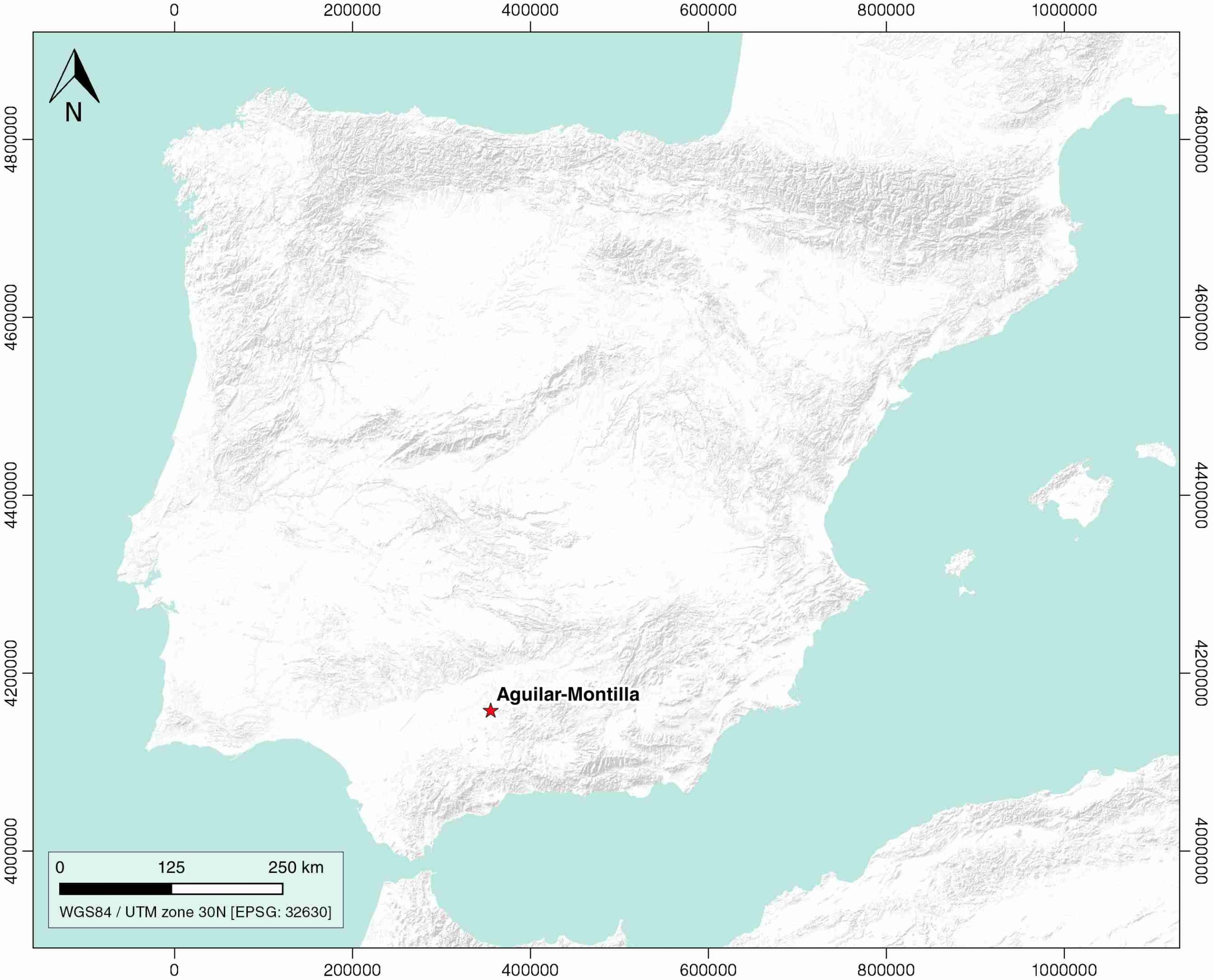
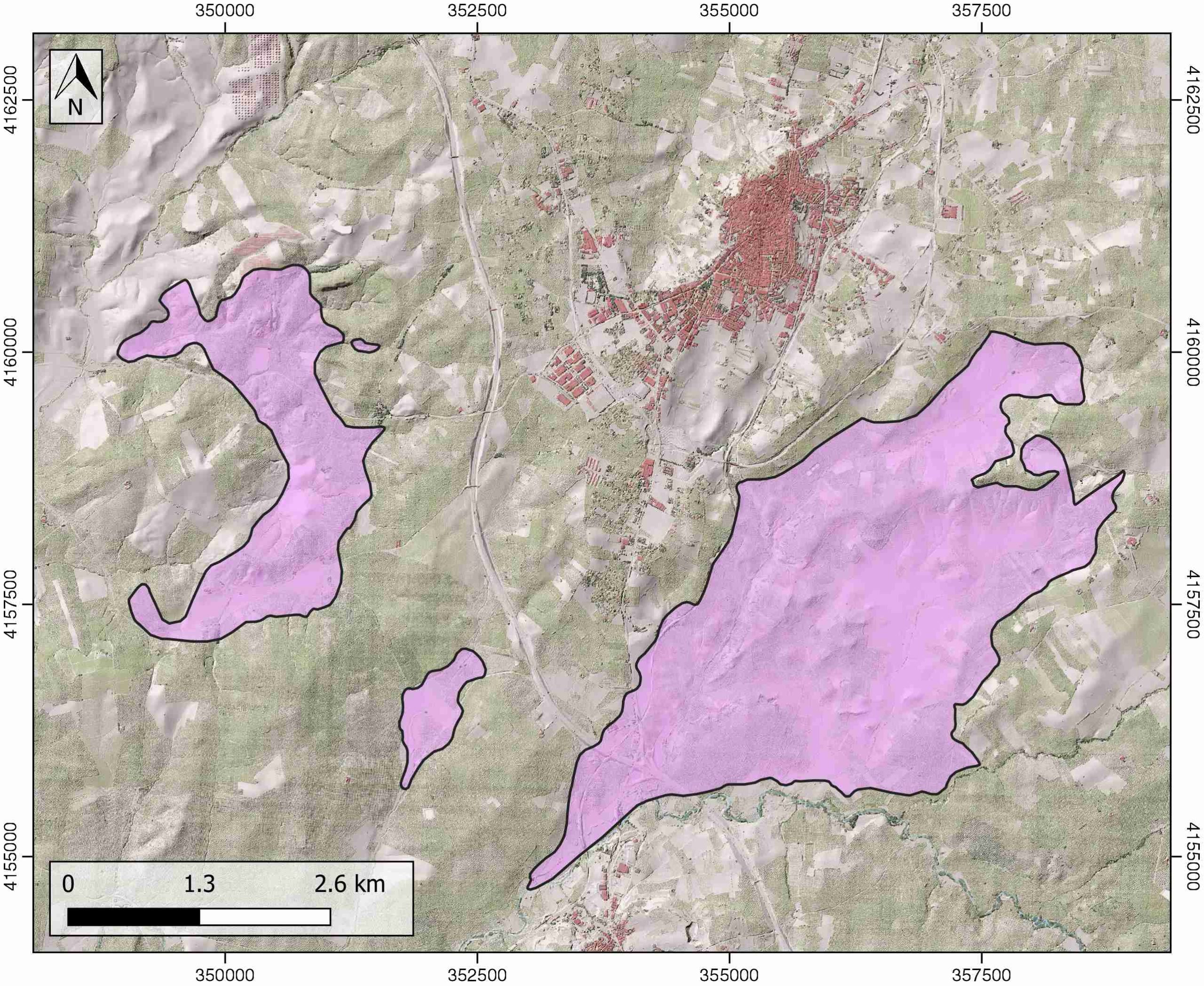
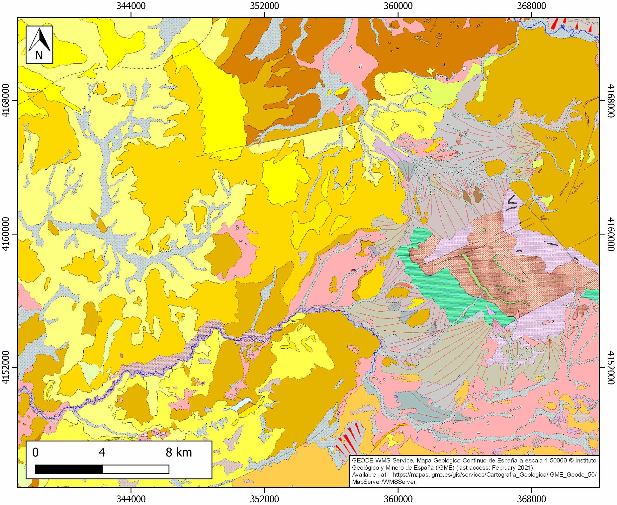
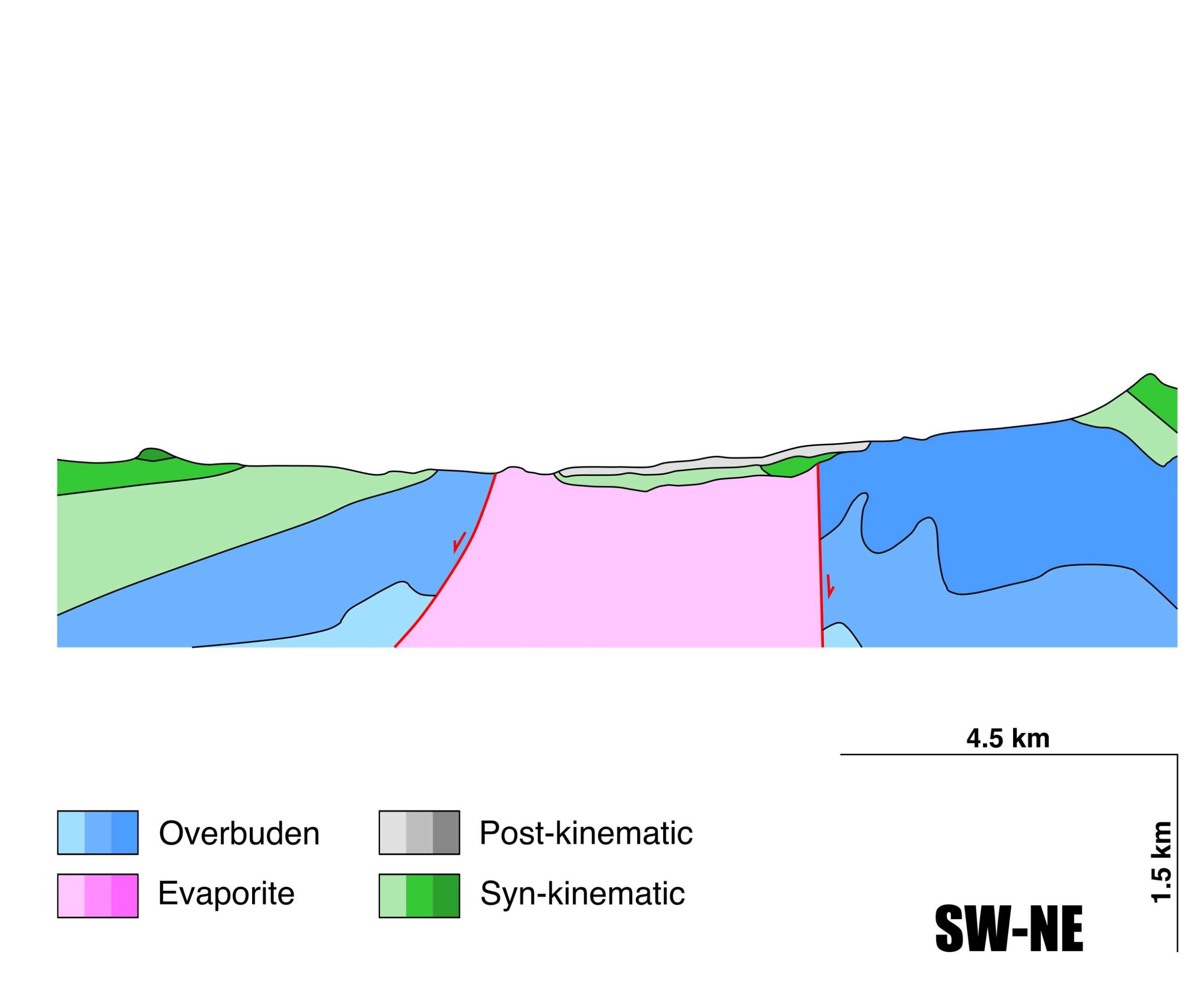
Aguilar-Montilla
ID #056
General Information
| Structure type | Evaporite Diapir |
| Deformed/Undeformed | Deformed |
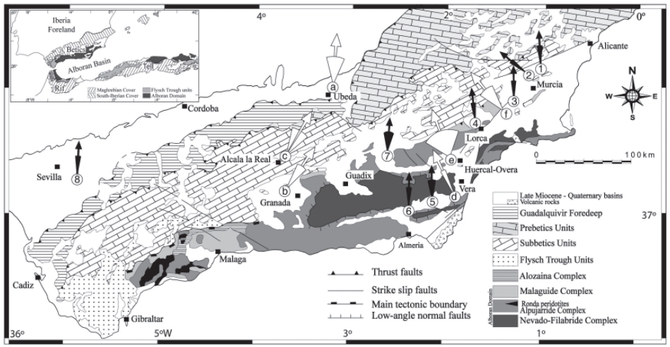
| Geological Setting | Betic system, Guadalquivir Accretionary Complex |
| Outcropping/buried | Outcropping |
| Evaporite unit/s name | Keuper facies |
| Evaporite unit/s age | Carnian-Rhaetian (Upper Triassic) |
| Evaporite unit/s origin | Marine |
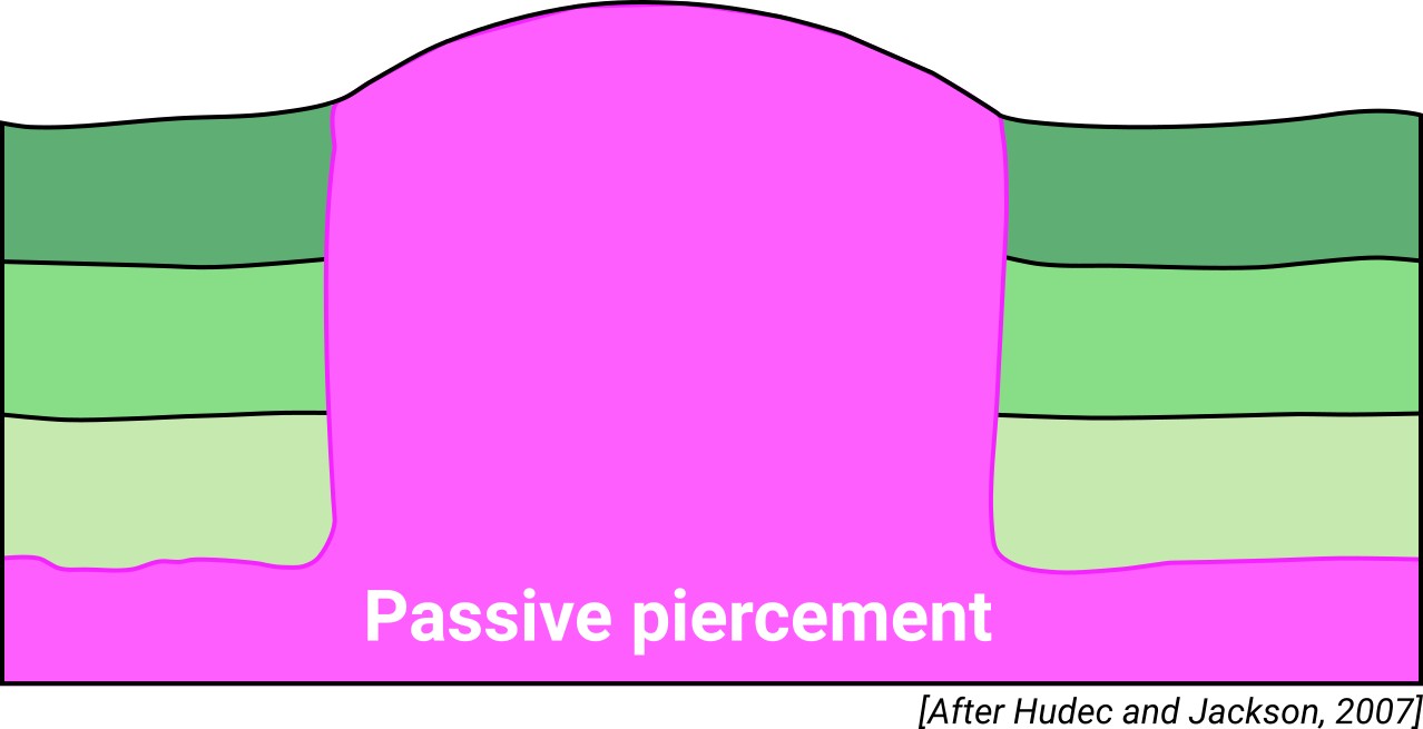
| Classif. (Hudec and Jackson, 2009) | Passive piercement |
| Classif. (Jackson and Talbot, 1986) | Salt pillow |
| Age of evaporite flow or deformation (when deformed) | Serravalian to Tortonian |
| Other comments | Northern termination of the Badolatosa-Benajemí allochthonous salt canopy (ID #104). |
Generic Data
| Unique ID | 56 |
| Name | Aguilar-Montilla |
| Structure type | Evaporite diapir |
| Deformed/Undeformed | Deformed |
| Buried/Outcropping | Outcropping |
| Geological setting | Betic System |
| Geological Regional Setting | Guadalquivir Accretionary Complex |
| Evaporite unit/s name | Keuper facies |
| Evaporite unit/s age | Carnian-Rhaetian (Upper Triassic) |
| Evaporite unit/s era | Mesozoic |
| Evaporite unit/s origin | Marine |
| Evaporite unit/s composition | Shale-Marlstone-Gypsum-Anhydrite |
| Post-kinematic unit/s (or post-evaporite units when evaporites are undeformed) | Quaternary (alluvial and colluvial detrital deposits) |
| Post-kinematic unit/s age (or post-evaporite units when evaporites are undeformed) | Pleistocene-Holocene |
| Classification (Hudec and Jackson, 2009) | Passive piercement |
| Classification (Jackson and Talbot, 1986) | Salt pillow |
| Mining activity? | Y |
| Mining activity start | |
| Mining activity end | |
| Mining galleries? | Y |
| Mining products | Salt springs, Gem Salt |
| Mining sub-products | |
| Evaporite flow? | Y |
| Age of evaporite flow | Serravallian – Mid Tortonian |
| Flow or deformation triggering mechanisms | |
| Flow-linked structures? | Y |
| Halokinetic structures | Normal faults / progressive unconformities |
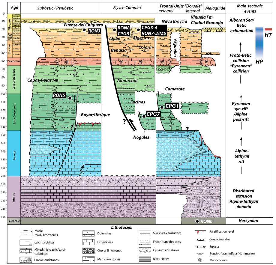
| Post-evaporite and pre-kinematic unit/s (overbuden) | Lower Jurassic ( marlstones, marly limestones) ; Lower Cretaceous (marlstones, red marlstones, red marly limestones) ; Lower Miocene (bioclastic limestones) |
| Syn-kinematic unit/s | Serravallian – Mid Tortonian (limestones and marls) |
| Available seismic profiles | CO-55 / S82A-2 / S82A-23 / S-83-46 / S-83-46 / RCO-6-1 / CO-28 / CO-55 / RCO-6 |
| Available boreholes | |
| Additional comments | Northern termination of the Badolatosa-Benajemí allochthonous salt canopy |
Mining Data
| UNIQUE_ID | 56 |
| Minning exploitations within <2km? | Y |
| Historical/Active | Active |
| Exploitation name #1 | SAN FRANCISCO |
| Exploitation ID (Spanish National Mining Cadastre) #1 | 11378 |
| Municipality #1 | Montilla |
| Province #1 | CORDOBA |
| Company #1 | HIJOS DE CURRO LOPEZ, S.L. |
| Main minning Products #1 | Salt springs, Gem Salt |
| Exploitation name #2 | |
| Exploitation ID (Spanish National Mining Cadastre) #2 | |
| Municipality #2 | |
| Province #2 | |
| Company #2 | |
| Main minning Products #2 | |
| Exploitation name #3 | |
| Exploitation ID (Spanish National Mining Cadastre) #3 | |
| Municipality #3 | |
| Province #3 | |
| Company #3 | |
| Main minning Products #3 |
Quantitative Data
| UNIQUE_ID | 56 |
| Outcropping area (km2) | 17.91834 |
| Horizontal intersection area (km2) (when buried) | Not buried |
| Depth of intersection area (km2) (when buried) | Not buried |
| Max. Width (Km) | 6.40418866 |
| Max. Length (Km) | 10.0141561 |
| Max. Evaporites thickness (km) | |
| Max. Deformation age (Ma) | 14 |
| Min. Deformation age (Ma) | 9 |
| Deformation stages | 1 |
Reference Data
| UNIQUE_ID | 56 |
| Section source | IGME MAGNA 50. SHEET 966 (MONTILLA) |
| Well / Borehole availability #1 | Flinch, J. F., Soto, J. I., 2017. Allochthonous Triassic and Salt Tectonic Processes in the Betic-Rif Orogenic Arc. In Permo-Triassic Salt Provinces of Europe, North Africa and the Atlantic Margins (pp. 417-446). Elsevier. [link] |
| Well / Borehole availability #2 | Fernandez, M., Berástegui, X., Puig, C., García-Castellanos, D., Jurado, M. J., Torné, M., Banks, C., 1998. Geophysical and geological constraints on the evolution of the Guadalquivir foreland basin, Spain. Geological Society, London, Special Publications, 134(1), 29-48. [link] |
| Available data (Stratigraphy) #1 | Sissingh, W., 2008. Punctuated Neogene tectonics and stratigraphy of the African-Iberian plate-boundary zone: Concurrent development of Betic-Rif basins (southern Spain, northern Morocco). Netherlands Journal of Geosciences/Geologie en Mijnbouw, 87(4), 241-289. [link] |
| Available data (Stratigraphy) #2 | Fernandez, M., Berástegui, X., Puig, C., García-Castellanos, D., Jurado, M. J., Torné, M., Banks, C., 1998. Geophysical and geological constraints on the evolution of the Guadalquivir foreland basin, Spain. Geological Society, London, Special Publications, 134(1), 29-48. [link] |
| Available data (Stratigraphy) #3 | Simon, O. J., 1987. On the Triassic of the Betic Cordilleras (Southern Spain). Cuadernos de Geología Ibérica, 11, 385-402. [link] |
| Available data (Stratigraphy) #4 | Flinch, J. F., Soto, J. I., 2017. Allochthonous Triassic and Salt Tectonic Processes in the Betic-Rif Orogenic Arc. In Permo-Triassic Salt Provinces of Europe, North Africa and the Atlantic Margins (pp. 417-446). Elsevier. [link] |
| Available data (Stratigraphy) #5 | Berástegui, X., Banks, C. J., Puig, C., Taberner, C., Waltham, D., Fernández, M., 1998. Lateral diapiric emplacement of Triassic evaporites at the southern margin of the Guadalquivir Basin, Spain. Geological Society, London, Special Publications, 134(1), 49-68. [link] |
| Available data (Stratigraphy) #6 | Martínez del Olmo, W., 2019. El complejo olistostrómico del Mioceno de la Cuenca del Río Guadalquivir (SO de España). Revista de la Sociedad Geológica de España, 32(2), 3-16. [link] |
| Regional Stratigraphy | Daudet, M., Mouthereau, F., Brichau, S., Crespo‐Blanc, A., Gautheron, C., Angrand, P., 2020. Tectono‐stratigraphic and thermal evolution of the western Betic flysch: implications for the geodynamics of South Iberian margin and Alboran Domain. Tectonics, 39(7), e2020TC006093. [link] |
| Seismic data availability #1 | Berástegui, X., Banks, C. J., Puig, C., Taberner, C., Waltham, D., Fernández, M., 1998. Lateral diapiric emplacement of Triassic evaporites at the southern margin of the Guadalquivir Basin, Spain. Geological Society, London, Special Publications, 134(1), 49-68. [link] |
| Seismic data availability #2 | Flinch, J. F., Soto, J. I., 2017. Allochthonous Triassic and Salt Tectonic Processes in the Betic-Rif Orogenic Arc. In Permo-Triassic Salt Provinces of Europe, North Africa and the Atlantic Margins (pp. 417-446). Elsevier. [link] |
| Seismic data availability #3 | Martínez del Olmo, W., 2019. El complejo olistostrómico del Mioceno de la Cuenca del Río Guadalquivir (SO de España). Revista de la Sociedad Geológica de España, 32(2), 3-16. [link] |
| Available data (Structure) #1 | Berástegui, X., Banks, C. J., Puig, C., Taberner, C., Waltham, D., Fernández, M., 1998. Lateral diapiric emplacement of Triassic evaporites at the southern margin of the Guadalquivir Basin, Spain. Geological Society, London, Special Publications, 134(1), 49-68. [link] |
| Available data (Structure) #2 | Martínez del Olmo, W., 2019. El complejo olistostrómico del Mioceno de la Cuenca del Río Guadalquivir (SO de España). Revista de la Sociedad Geológica de España, 32(2), 3-16. [link] |
| Available data (Structure) #3 | Frasca, G., Gueydan, F., Brun, J. P., 2015. Structural record of Lower Miocene westward motion of the Alboran Domain in the Western Betics, Spain. Tectonophysics, 657, 1-20. [link] |
| Available data (Structure) #4 | Garcia‐Castellanos, D., Fernandez, M., Torné, M., 2002. Modeling the evolution of the Guadalquivir foreland basin (southern Spain). Tectonics, 21(3), 9-1. [link] |
| Available data (Structure) #5 | Flinch, J. F., Soto, J. I., 2017. Allochthonous Triassic and Salt Tectonic Processes in the Betic-Rif Orogenic Arc. In Permo-Triassic Salt Provinces of Europe, North Africa and the Atlantic Margins (pp. 417-446). Elsevier. [link] |
| Available data (Structure) #6 | Marín‐Lechado, C., Pedrera, A., Peláez, J. A., Ruiz‐Constán, A., González‐Ramón, A., Henares, J., 2017. Deformation style and controlling geodynamic processes at the eastern Guadalquivir foreland basin (Southern Spain). Tectonics, 36(6), 1072-1089. [link] |
| Available data (Analogue modelling) #1 | Frasca, G., Gueydan, F., Brun, J. P., 2015. Structural record of Lower Miocene westward motion of the Alboran Domain in the Western Betics, Spain. Tectonophysics, 657, 1-20. [link] |
| Available data (Analogue modelling) #2 | n.a. |
| Available data (Analogue modelling) #3 | n.a. |
| Available data (Gravimetry – Tomography) #1 | Garcia‐Castellanos, D., Fernandez, M., Torné, M., 2002. Modeling the evolution of the Guadalquivir foreland basin (southern Spain). Tectonics, 21(3), 9-1. [link] |
| Available data (Gravimetry – Tomography) #2 | Ayala, C., Bohoyo, F., Maestro, A., Reguera, M. I., Torne, M., Rubio, F., Fernández, M., García-Lobón, J. L., 2016. Updated Bouguer anomalies of the Iberian Peninsula: a new perspective to interpret the regional geology. Journal of Maps, 12(5), 1089-1092. [link] |
| Available data (Gravimetry – Tomography) #3 | n.a. |
| Available data (Geochemistry) #1 | n.a. |
| Available data (Geochemistry) #2 | n.a. |
| Available data (Geochemistry) #3 | n.a. |
| Available data (Geochemistry) #4 | n.a. |
| Available data (Petrophysics) #1 | n.a. |
| Available data (Petrophysics) #2 | n.a. |
| IGME Geological Map (MAGNA50) Sheet number | 966-Montilla. [link] |
| Other Maps #1 (source) | Permanyer, A., Jorge, R., Baudino, R., Gibert, L., 2016. Organic-rich shales from internal Betic basins (SE Spain): potential source rocks analogs for the pre-Messinian Salt play in the western Mediterranean. Geologica Acta, 14(4), 443-460. [link] |
| Other Maps #2 (source) | Mattei, M., Cifelli, F., Funiciello, F., Rossetti, F., Faccenna, C., 2007. Neogene tectonic evolution of the Betic Chain: insights from paleomagnetic, structural analyses, and laboratory models. Revista de la Sociedad Geológica de España, 20(3), 273-285. [link] |
| Other related references #1 | n.a. |
| Other related references #2 | n.a. |
| Other related references #3 | n.a. |
| Other related references #4 | n.a. |
Well and Seismic Data
| UNIQUE_ID | 56 |
| Seismic survey name #1 | 6J-ST-24 |
| Across structure? #1 | Y |
| Seismic profile ID (IGME) #1 | 12397 |
| Seismic profile code #1 | 17115 |
| Seismic profile name #1 | CO-55 |
| Seismic survey year #1 | 1972 |
| Data repository #1 | SIGEOF Data Catalogue (Private access section). ©Instituto Geológico y Minero de España (IGME). https://info.igme.es/SIGEOF/ |
| Length (km) #1 | 14.82 |
| Seismic survey name #2 | 6K4-S82A |
| Across structure? #2 | N (within 3km) |
| Seismic profile ID (IGME) #2 | 11445 |
| Seismic profile code #2 | 16098 |
| Seismic profile name #2 | S82A-2 |
| Seismic survey year #2 | 1982 |
| Data repository #2 | SIGEOF Data Catalogue (Section available under request). ©Instituto Geológico y Minero de España (IGME). https://info.igme.es/SIGEOF/ |
| Length (km) #2 | 48.52 |
| Seismic survey name #3 | 6J3-S82A |
| Across structure? #3 | N (within 3km) |
| Seismic profile ID (IGME) #3 | 11121 |
| Seismic profile code #3 | 15760 |
| Seismic profile name #3 | S82A-23 |
| Seismic survey year #3 | 1982 |
| Data repository #3 | SIGEOF Data Catalogue (Section available under request). ©Instituto Geológico y Minero de España (IGME). https://info.igme.es/SIGEOF/ |
| Length (km) #3 | 51.02 |
| Seismic survey name #4 | 0210A83G |
| Across structure? #4 | N (within 3km) |
| Seismic profile ID (IGME) #4 | 5780 |
| Seismic profile code #4 | 9531 |
| Seismic profile name #4 | S-83-46 |
| Seismic survey year #4 | 1983 |
| Data repository #4 | SIGEOF Data Catalogue (Private access section). ©Instituto Geológico y Minero de España (IGME). https://info.igme.es/SIGEOF/ |
| Length (km) #4 | 10.13 |
| Seismic survey name #5 | 0210A83S |
| Across structure? #5 | N (within 3km) |
| Seismic profile ID (IGME) #5 | 5794 |
| Seismic profile code #5 | 9545 |
| Seismic profile name #5 | S-83-46 |
| Seismic survey year #5 | 1983 |
| Data repository #5 | SIGEOF Data Catalogue (Private access section). ©Instituto Geológico y Minero de España (IGME). https://info.igme.es/SIGEOF/ |
| Length (km) #5 | 25.36 |
| Seismic survey name #6 | 6J-ST-13 |
| Across structure? #6 | N (within 3km) |
| Seismic profile ID (IGME) #6 | 12378 |
| Seismic profile code #6 | 17096 |
| Seismic profile name #6 | RCO-6-1 |
| Seismic survey year #6 | 1966 |
| Data repository #6 | SIGEOF Data Catalogue (Private access section). ©Instituto Geológico y Minero de España (IGME). https://info.igme.es/SIGEOF/ |
| Length (km) #6 | 6.29 |
| Seismic survey name #7 | 6J-ST-17 |
| Across structure? #7 | N (within 3km) |
| Seismic profile ID (IGME) #7 | 12387 |
| Seismic profile code #7 | 17105 |
| Seismic profile name #7 | CO-28 |
| Seismic survey year #7 | 1967 |
| Data repository #7 | SIGEOF Data Catalogue (Private access section). ©Instituto Geológico y Minero de España (IGME). https://info.igme.es/SIGEOF/ |
| Length (km) #7 | 7.48 |
| Seismic survey name #8 | 6J-ST-24 |
| Across structure? #8 | N (within 3km) |
| Seismic profile ID (IGME) #8 | 12397 |
| Seismic profile code #8 | 17115 |
| Seismic profile name #8 | CO-55 |
| Seismic survey year #8 | 1972 |
| Data repository #8 | SIGEOF Data Catalogue (Private access section). ©Instituto Geológico y Minero de España (IGME). https://info.igme.es/SIGEOF/ |
| Length (km) #8 | 14.82 |
| Seismic survey name #9 | 6J-ST-13 |
| Across structure? #9 | N (within 3km) |
| Seismic profile ID (IGME) #9 | 12379 |
| Seismic profile code #9 | 17097 |
| Seismic profile name #9 | RCO-6 |
| Seismic survey year #9 | 1966 |
| Data repository #9 | SIGEOF Data Catalogue (Private access section). ©Instituto Geológico y Minero de España (IGME). https://info.igme.es/SIGEOF/ |
| Length (km) #9 | 30.83 |
| Seismic survey name #10 | |
| Across structure? #10 | |
| Seismic profile ID (IGME) #10 | |
| Seismic profile code #10 | |
| Seismic profile name #10 | |
| Seismic survey year #10 | |
| Data repository #10 | |
| Length (km) #10 | |
| Seismic survey name #11 | |
| Across structure? #11 | |
| Seismic profile ID (IGME) #11 | |
| Seismic profile code #11 | |
| Seismic profile name #11 | |
| Seismic survey year #11 | |
| Data repository #11 | |
| Length (km) #11 | |
| Seismic survey name #12 | |
| Across structure? #12 | |
| Seismic profile ID (IGME) #12 | |
| Seismic profile code #12 | |
| Seismic profile name #12 | |
| Seismic survey year #12 | |
| Data repository #12 | |
| Length (km) #12 | |
| Seismic survey name #13 | |
| Across structure? #13 | |
| Seismic profile ID (IGME) #13 | |
| Seismic profile code #13 | |
| Seismic profile name #13 | |
| Seismic survey year #13 | |
| Data repository #13 | |
| Length (km) #13 | |
| Seismic survey name #14 | |
| Across structure? #14 | |
| Seismic profile ID (IGME) #14 | |
| Seismic profile code #14 | |
| Seismic profile name #14 | |
| Seismic survey year #14 | |
| Data repository #14 | |
| Length (km) #14 | |
| Seismic survey name #15 | |
| Across structure? #15 | |
| Seismic profile ID (IGME) #15 | |
| Seismic profile code #15 | |
| Seismic profile name #15 | |
| Seismic survey year #15 | |
| Data repository #15 | |
| Length (km) #15 | |
| Seismic survey name #16 | |
| Across structure? #16 | |
| Seismic profile ID (IGME) #16 | |
| Seismic profile code #16 | |
| Seismic profile name #16 | |
| Seismic survey year #16 | |
| Data repository #16 | |
| Length (km) #16 | |
| Seismic survey name #17 | |
| Across structure? #17 | |
| Seismic profile ID (IGME) #17 | |
| Seismic profile code #17 | |
| Seismic profile name #17 | |
| Seismic survey year #17 | |
| Data repository #17 | |
| Length (km) #17 | |
| Seismic survey name #18 | |
| Across structure? #18 | |
| Seismic profile ID (IGME) #18 | |
| Seismic profile code #18 | |
| Seismic profile name #18 | |
| Seismic survey year #18 | |
| Data repository #18 | |
| Length (km) #18 | |
| Seismic survey name #19 | |
| Across structure? #19 | |
| Seismic profile ID (IGME) #19 | |
| Seismic profile code #19 | |
| Seismic profile name #19 | |
| Seismic survey year #19 | |
| Data repository #19 | |
| Length (km) #19 | |
| Seismic survey name #20 | |
| Across structure? #20 | |
| Seismic profile ID (IGME) #20 | |
| Seismic profile code #20 | |
| Seismic profile name #20 | |
| Seismic survey year #20 | |
| Data repository #20 | |
| Length (km) #20 | |
| Seismic survey name #21 | |
| Across structure? #21 | |
| Seismic profile ID (IGME) #21 | |
| Seismic profile code #21 | |
| Seismic profile name #21 | |
| Seismic survey year #21 | |
| Data repository #21 | |
| Length (km) #21 | |
| Borehole name #1 | |
| Company #1 | |
| Traget #1 | |
| Across structure? #1 | |
| Borehole name #2 | |
| Company #2 | |
| Traget #2 | |
| Across structure? #2 | |
| Borehole name #3 | |
| Company #3 | |
| Traget #3 | |
| Across structure? #3 | |
| Borehole name #4 | |
| Company #4 | |
| Traget #4 | |
| Across structure? #4 | |
| Borehole name #5 | |
| Company #5 | |
| Traget #5 | |
| Across structure? #5 | |
| Borehole name #6 | |
| Company #6 | |
| Traget #6 | |
| Across structure? #6 | |
| Borehole name #7 | |
| Company #7 | |
| Traget #7 | |
| Across structure? #7 | |
| Borehole name #8 | |
| Company #8 | |
| Traget #8 | |
| Across structure? #8 | |
| Borehole name #9 | |
| Company #9 | |
| Traget #9 | |
| Across structure? #9 | |
| Borehole name #10 | |
| Company #10 | |
| Traget #10 | |
| Across structure? #10 | |
| Borehole name #11 | |
| Company #11 | |
| Traget #11 | |
| Across structure? #11 | |
| Borehole name #12 | |
| Company #12 | |
| Traget #12 | |
| Across structure? #12 | |
| Borehole name #13 | |
| Company #13 | |
| Traget #13 | |
| Across structure? #13 | |
| Borehole name #14 | |
| Company #14 | |
| Traget #14 | |
| Across structure? #14 | |
| Borehole name #15 | |
| Company #15 | |
| Traget #15 | |
| Across structure? #15 |
Geographical Data (EPSG:4326 - WGS 84)
| UNIQUE_ID | 56 |
| X Centroid (Structure shape) | -4.644210 |
| Y Centroid (Structure shape) | -4.644210 |
| Xmin (Structure shape) | -4.710724 |
| Xmax (Structure shape) | -4.597496 |
| Ymin (Structure shape) | 37.527314 |
| Ymax (Structure shape) | 37.582728 |
| Xmin seismic line #1 | -4.774830 |
| Xmax seismic line #1 | -4.671904 |
| Ymin seismic line #1 | 37.518333 |
| Ymax seismic line #1 | 37.623204 |
| Xmin seismic line #2 | -4.596735 |
| Xmax seismic line #2 | -4.559096 |
| Ymin seismic line #2 | 37.158439 |
| Ymax seismic line #2 | 37.580710 |
| Xmin seismic line #3 | -5.001587 |
| Xmax seismic line #3 | -4.512991 |
| Ymin seismic line #3 | 37.396314 |
| Ymax seismic line #3 | 37.564435 |
| Xmin seismic line #4 | -4.749203 |
| Xmax seismic line #4 | -4.714203 |
| Ymin seismic line #4 | 37.591133 |
| Ymax seismic line #4 | 37.676606 |
| Xmin seismic line #5 | -4.802260 |
| Xmax seismic line #5 | -4.714425 |
| Ymin seismic line #5 | 37.591632 |
| Ymax seismic line #5 | 37.805693 |
| Xmin seismic line #6 | -4.653678 |
| Xmax seismic line #6 | -4.587472 |
| Ymin seismic line #6 | 37.572277 |
| Ymax seismic line #6 | 37.593122 |
| Xmin seismic line #7 | -4.592335 |
| Xmax seismic line #7 | -4.532243 |
| Ymin seismic line #7 | 37.523887 |
| Ymax seismic line #7 | 37.563514 |
| Xmin seismic line #8 | -4.774830 |
| Xmax seismic line #8 | -4.671904 |
| Ymin seismic line #8 | 37.518333 |
| Ymax seismic line #8 | 37.623204 |
| Xmin seismic line #9 | -5.018896 |
| Xmax seismic line #9 | -4.695492 |
| Ymin seismic line #9 | 37.456804 |
| Ymax seismic line #9 | 37.560211 |
| Xmin seismic line #10 | |
| Xmax seismic line #10 | |
| Ymin seismic line #10 | |
| Ymax seismic line #10 | |
| Xmin seismic line #11 | |
| Xmax seismic line #11 | |
| Ymin seismic line #11 | |
| Ymax seismic line #11 | |
| Xmin seismic line #12 | |
| Xmax seismic line #12 | |
| Ymin seismic line #12 | |
| Ymax seismic line #12 | |
| Xmin seismic line #13 | |
| Xmax seismic line #13 | |
| Ymin seismic line #13 | |
| Ymax seismic line #13 | |
| Xmin seismic line #14 | |
| Xmax seismic line #14 | |
| Ymin seismic line #14 | |
| Ymax seismic line #14 | |
| Xmin seismic line #15 | |
| Xmax seismic line #15 | |
| Ymin seismic line #15 | |
| Ymax seismic line #15 | |
| Xmin seismic line #16 | |
| Xmax seismic line #16 | |
| Ymin seismic line #16 | |
| Ymax seismic line #16 | |
| Xmin seismic line #17 | |
| Xmax seismic line #17 | |
| Ymin seismic line #17 | |
| Ymax seismic line #17 | |
| Xmin seismic line #18 | |
| Xmax seismic line #18 | |
| Ymin seismic line #18 | |
| Ymax seismic line #18 | |
| Xmin seismic line #19 | |
| Xmax seismic line #19 | |
| Ymin seismic line #19 | |
| Ymax seismic line #19 | |
| Xmin seismic line #20 | |
| Xmax seismic line #20 | |
| Ymin seismic line #20 | |
| Ymax seismic line #20 | |
| Xmin seismic line #21 | |
| Xmax seismic line #21 | |
| Ymin seismic line #21 | |
| Ymax seismic line #21 | |
| X borehole #1 | |
| Y borehole #1 | |
| X borehole #2 | |
| Y borehole #2 | |
| X borehole #3 | |
| Y borehole #3 | |
| X borehole #4 | |
| Y borehole #4 | |
| X borehole #5 | |
| Y borehole #5 | |
| X borehole #6 | |
| Y borehole #6 | |
| X borehole #7 | |
| Y borehole #7 | |
| X borehole #8 | |
| Y borehole #8 | |
| X borehole #9 | |
| Y borehole #9 | |
| X borehole #10 | |
| Y borehole #10 | |
| X borehole #11 | |
| Y borehole #11 | |
| X borehole #12 | |
| Y borehole #12 | |
| X borehole #13 | |
| Y borehole #13 | |
| X borehole #14 | |
| Y borehole #14 | |
| X borehole #15 | |
| Y borehole #15 |

