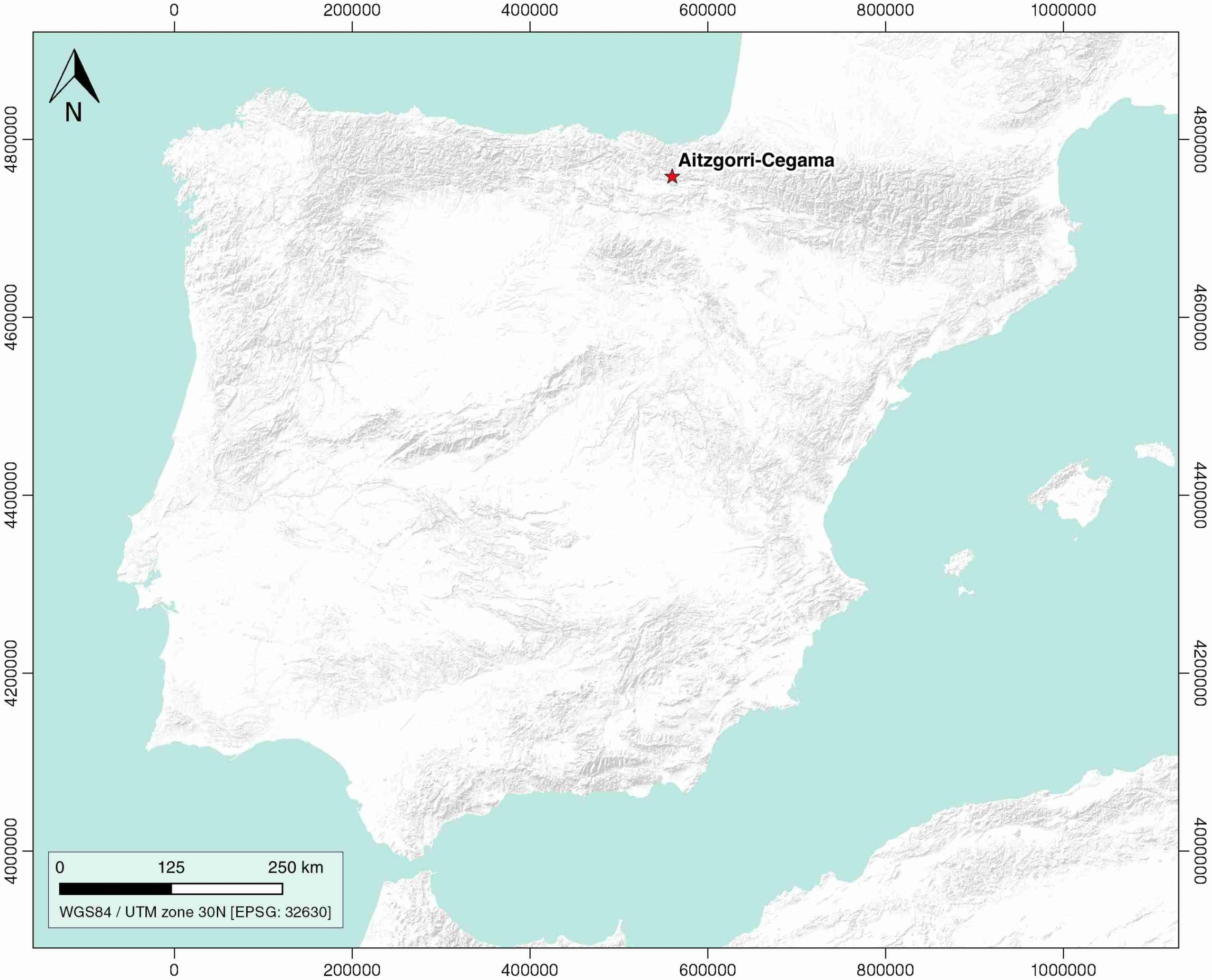
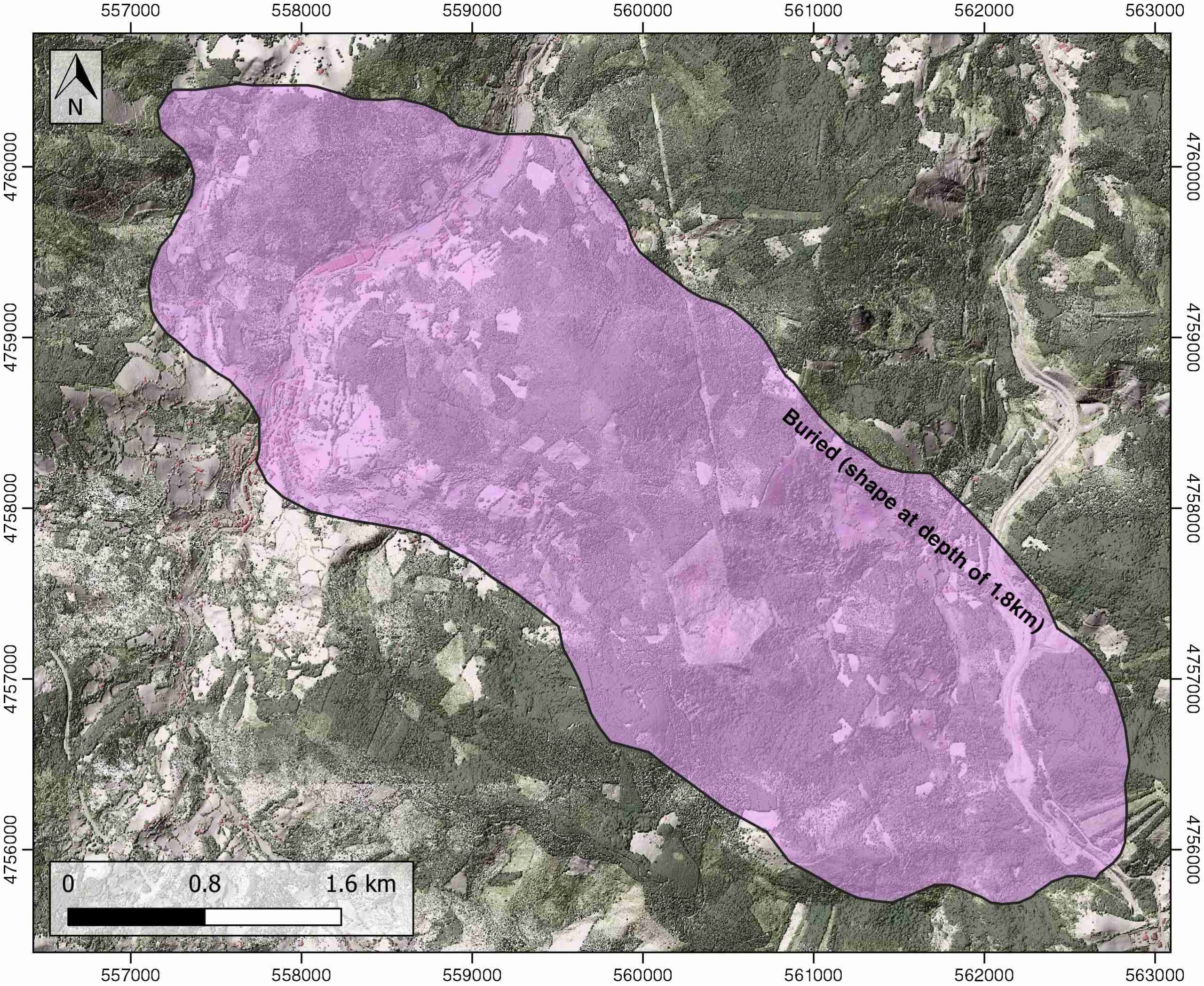
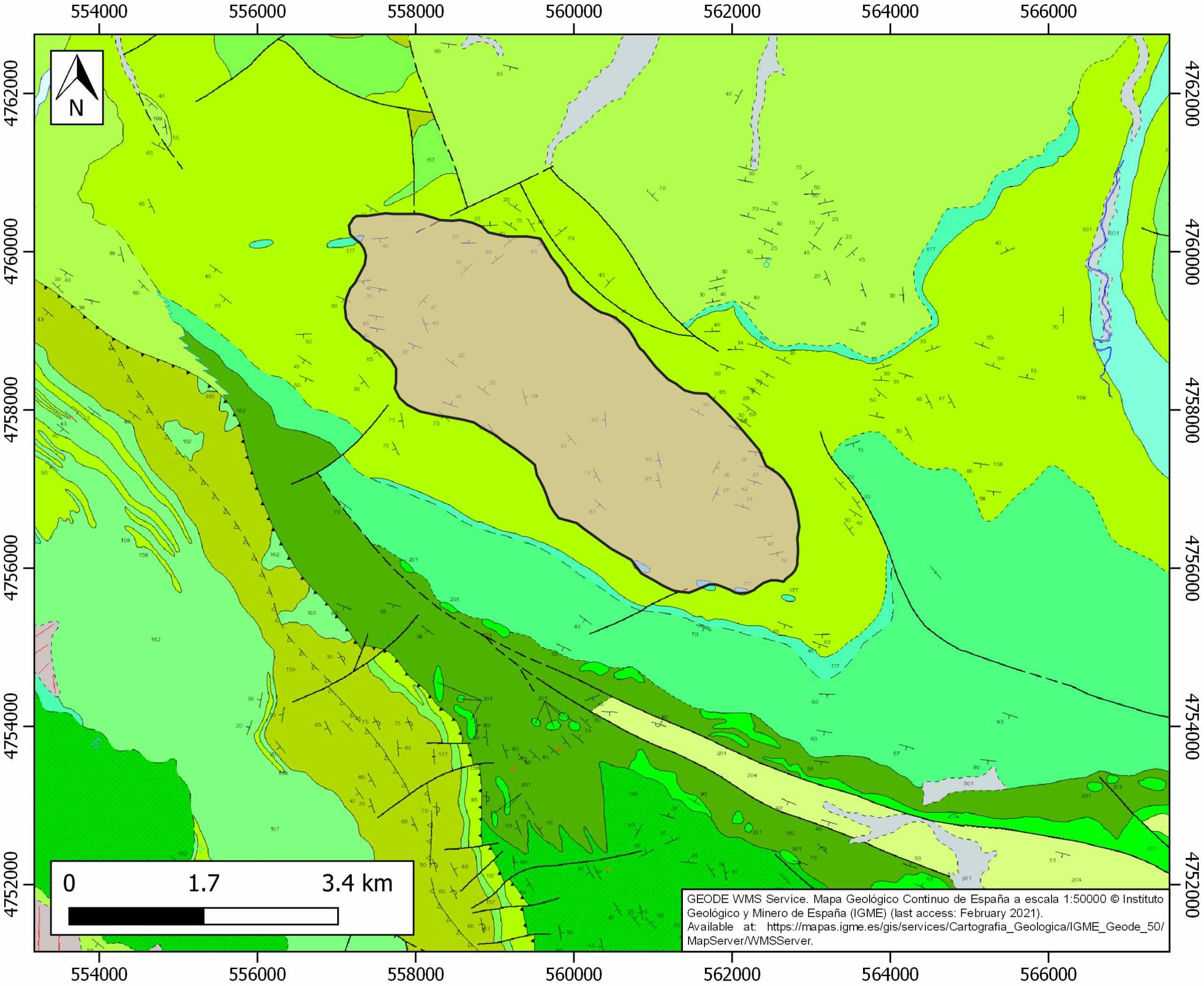
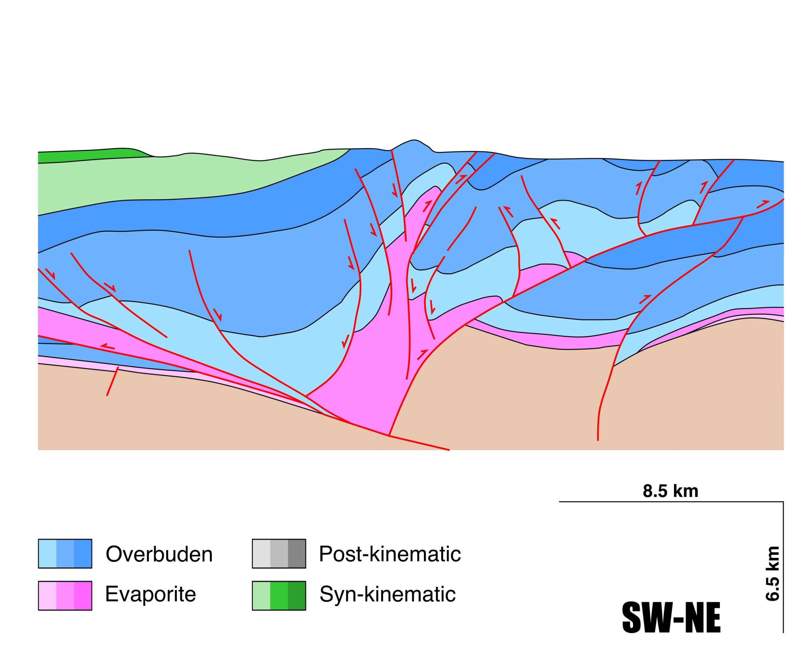
Aitzgorri-Cegama
ID #047
General Information
| Structure type | Evaporite-cored anticline |
| Deformed/Undeformed | Deformed |
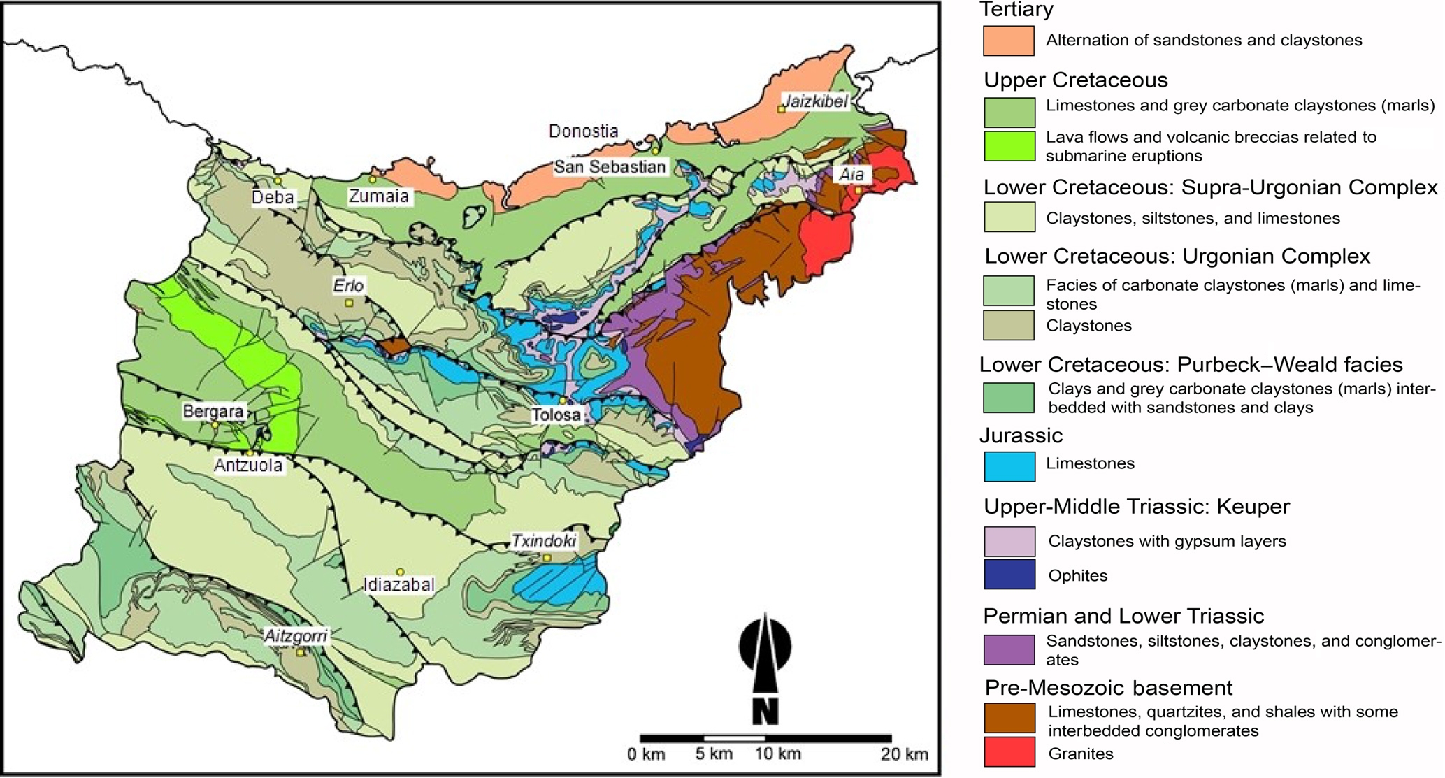
| Geological Setting | Basque-Cantabrian Basin, Navarra-Álava trough |
| Outcropping/buried | Buried |
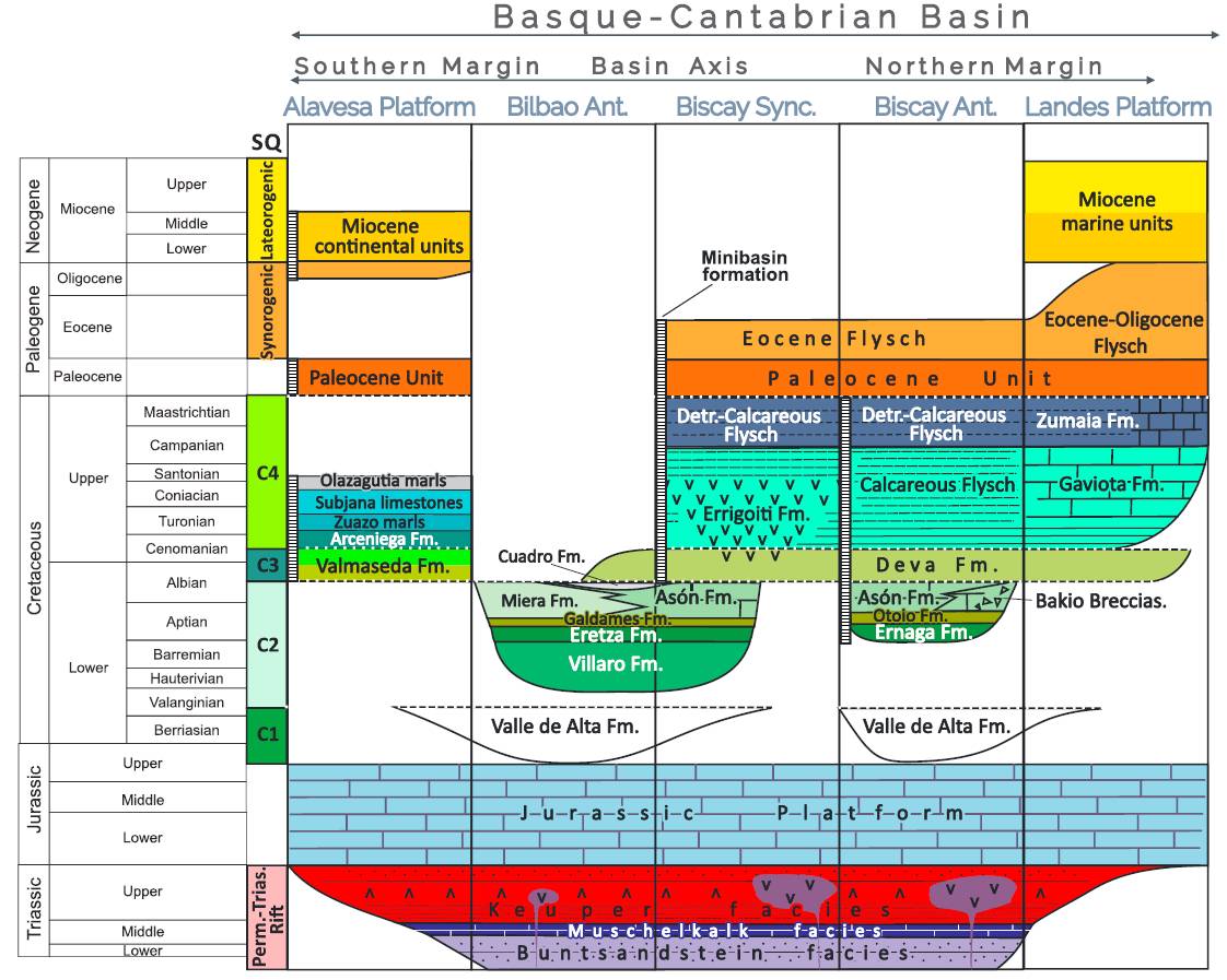
| Evaporite unit/s name | Keuper facies |
| Evaporite unit/s age | Carnian-Rhaetian (Upper Triassic) |
| Evaporite unit/s origin | Marine |
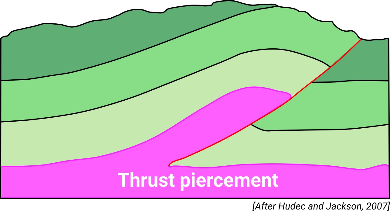
| Classif. (Hudec and Jackson, 2009) | Thrust piercement |
| Classif. (Jackson and Talbot, 1986) | Salt roller |
| Age of evaporite flow or deformation (when deformed) | Middle Cretaceous |
| Other comments | Interpreted as an inverted diapiric structure thrusted towards the north during the Tertiary (see Camara, 2017). The evaporites of the Bilbao anticline core could be attributed to both the Upper Jurassic (Purbeck, see Abalos et al., 2008) and the Triassic age (Keuper, see Camara, 2017, 2020). |
Generic Data
| Unique ID | 47 |
| Name | Aitzgorri-Cegama |
| Structure type | Evaporite-cored anticline |
| Deformed/Undeformed | Deformed |
| Buried/Outcropping | Buried |
| Geological setting | Basque-Cantabrian Basin |
| Geological Regional Setting | Navarra-Álava trough |
| Evaporite unit/s name | Keuper facies |
| Evaporite unit/s age | Carnian-Rhaetian (Upper Triassic) |
| Evaporite unit/s era | Mesozoic |
| Evaporite unit/s origin | Marine |
| Evaporite unit/s composition | Gypsum-Halite-Anhydrite-Claystone |
| Post-kinematic unit/s (or post-evaporite units when evaporites are undeformed) | Quaternary (alluvial and colluvial detrital deposits) |
| Post-kinematic unit/s age (or post-evaporite units when evaporites are undeformed) | Pleistocene-Holocene |
| Classification (Hudec and Jackson, 2009) | Thrust piercement |
| Classification (Jackson and Talbot, 1986) | Salt roller |
| Mining activity? | N |
| Mining activity start | |
| Mining activity end | |
| Mining galleries? | |
| Mining products | |
| Mining sub-products | |
| Evaporite flow? | Y |
| Age of evaporite flow | Upper Albian – Cenomanian |
| Flow or deformation triggering mechanisms | Upper Eocene-Miocene Alpine compression: inversion of the north dipping listric faults produced southern vergence thrusts |
| Flow-linked structures? | Y |
| Halokinetic structures | Normal high-angle faults / thrust faults / thickness variations |
| Post-evaporite and pre-kinematic unit/s (overbuden) | Late Jurassic-Early Cretaceous (Purbeck facies, Clays, limestones and sandstones) ; Lower Cretaceous (Weald facies, limestones and sandstones) ; Aptian-Albian (Urgonian facies, limestones and sandstones) |
| Syn-kinematic unit/s | Upper Albian – Cenomanian (Supraurgonian, Valmaseda Fm., shales and sandstones) |
| Available seismic profiles | SEG-9 / SEG-6 / SEG-5 / SEG-5-1 / SEG-1 / SEG-4 / ATZ-2 / ATZ-IN / SEG-6 / SEG-9 / SEG-5 |
| Available boreholes | MINA TROYA C-29 / MINA TROYA C-30 / MINA TROYA C-27 / MINA TROYA C-28 / MINA TROYA T-045 / MINA TROYA T-047 / MINA TROYA C-31 / MINA TROYA T-025 / MINA TROYA T-082 / MINA TROYA T-088 / BARBARIS-1 (BAB-1) / BARBARIS-2 (BAB-2) / MINA TROYA T-048 / DOMO-1 / DOMO-2 |
| Additional comments | Interpreted as an inverted diapiric structure thrusted towards the north during the Tertiary (see Camara, 2017). The evaporites of the Bilbao anticline core could be attributed to both the Upper Jurassic (Purbeck, see Abalos et al., 2008) and the Triassic age (Keuper, see Camara, 2017, 2020). |
Mining Data
| UNIQUE_ID | 47 |
| Minning exploitations within <2km? | N |
| Historical/Active | |
| Exploitation name #1 | |
| Exploitation ID (Spanish National Mining Cadastre) #1 | |
| Municipality #1 | |
| Province #1 | |
| Company #1 | |
| Main minning Products #1 | |
| Exploitation name #2 | |
| Exploitation ID (Spanish National Mining Cadastre) #2 | |
| Municipality #2 | |
| Province #2 | |
| Company #2 | |
| Main minning Products #2 | |
| Exploitation name #3 | |
| Exploitation ID (Spanish National Mining Cadastre) #3 | |
| Municipality #3 | |
| Province #3 | |
| Company #3 | |
| Main minning Products #3 |
Quantitative Data
| UNIQUE_ID | 47 |
| Outcropping area (km2) | Buried |
| Horizontal intersection area (km2) (when buried) | 13.56085 |
| Depth of intersection area (km2) (when buried) | 1.8 |
| Max. Width (Km) | 7.13214669 |
| Max. Length (Km) | 2.68906514 |
| Max. Evaporites thickness (km) | 0.8 |
| Max. Deformation age (Ma) | 105 |
| Min. Deformation age (Ma) | 94 |
| Deformation stages | 1 |
Reference Data
| UNIQUE_ID | 47 |
| Section source | Cámara, P., 2017. Salt and Strike-Slip Tectonics as Main Drivers in the Structural Evolution of the Basque-Cantabrian Basin, Spain. In Permo-Triassic Salt Provinces of Europe, North Africa and the Atlantic Margins (pp. 371-393). Elsevier. [link] |
| Well / Borehole availability #1 | Cámara, P., 2017. Salt and Strike-Slip Tectonics as Main Drivers in the Structural Evolution of the Basque-Cantabrian Basin, Spain. In Permo-Triassic Salt Provinces of Europe, North Africa and the Atlantic Margins (pp. 371-393). Elsevier. [link] |
| Well / Borehole availability #2 | Grafe, K. U., Wiedmann, J., 1993. Sequence stratigraphy in the Upper Cretaceous of the Basco-Cantabrian Basin (northern Spain). Geologische Rundschau, 82(2), 327-361. [link] |
| Available data (Stratigraphy) #1 | Cámara, P., 2017. Salt and Strike-Slip Tectonics as Main Drivers in the Structural Evolution of the Basque-Cantabrian Basin, Spain. In Permo-Triassic Salt Provinces of Europe, North Africa and the Atlantic Margins (pp. 371-393). Elsevier. [link] |
| Available data (Stratigraphy) #2 | Fernández-Mendiola, P., 1988. Microfacies types in Aptian-Albian carbonate platforms, Central Basque-Cantabrian basin, Northern Spain. KOBIE (Série ciencias naturales) Bilbao, XVII,25-47. [link] |
| Available data (Stratigraphy) #3 | Fernández-Mendiola, P. A., García-Mondéjar, J., 1991. Depositional history of Aptian-Albian carbonate platforms: Aitzgorri Massif, northern Spain. Cretaceous research, 12(3), 293-320. [link] |
| Available data (Stratigraphy) #4 | Cámara, P., 2020. Inverted turtle salt anticlines in the eastern basque-cantabrian basin, Spain. Marine and Petroleum Geology, 104358. [link] |
| Available data (Stratigraphy) #5 | Grafe, K. U., Wiedmann, J., 1993. Sequence stratigraphy in the Upper Cretaceous of the Basco-Cantabrian Basin (northern Spain). Geologische Rundschau, 82(2), 327-361. [link] |
| Available data (Stratigraphy) #6 | Serrano, A., Martínez del Olmo, W., 1990. Tectónica salina en el Dominio Cántabro-Navarro: Evolución, edad y origen de las estructuras salinas, in Ortí, F., and Salvany, J.M., (eds.), Formaciones evaporíticas de la Cuenca del Ebro y cadenas periféricas, y de la zona de Levante. Barcelona, ENRESA. [link] |
| Regional Stratigraphy | Pedrera, A., García‐Senz, J., Ayala, C., Ruiz‐Constán, A., Rodríguez‐Fernández, L. R., Robador, A., González Menéndez, L., 2017. Reconstruction of the exhumed mantle across the North Iberian Margin by crustal‐scale 3‐D gravity inversion and geological cross section. Tectonics, 36, 3155-3177. [link] |
| Seismic data availability #1 | Cámara, P., 2017. Salt and Strike-Slip Tectonics as Main Drivers in the Structural Evolution of the Basque-Cantabrian Basin, Spain. In Permo-Triassic Salt Provinces of Europe, North Africa and the Atlantic Margins (pp. 371-393). Elsevier. [link] |
| Seismic data availability #2 | Serrano, A., Martínez del Olmo, W., 2004. Estructuras diapíricas de la zona meridional de la Cuenca Vasco-Cantábrica. In: Vera, J.A. (Ed.), Geología de España. Sociedad Geológica de España. Instituto Geológico y Minero de España, Madrid, pp. 334–338. [link] |
| Seismic data availability #3 | Cámara, P., 2020. Inverted turtle salt anticlines in the eastern basque-cantabrian basin, Spain. Marine and Petroleum Geology, 104358. [link] |
| Available data (Structure) #1 | Ábalos, B., Alkorta, A., Iríbar, V., 2008. Geological and isotopic constraints on the structure of the Bilbao anticlinorium (Basque–Cantabrian basin, North Spain). Journal of Structural Geology, 30(11), 1354-1367. [link] |
| Available data (Structure) #2 | Cámara, P., 2020. Inverted turtle salt anticlines in the eastern basque-cantabrian basin, Spain. Marine and Petroleum Geology, 104358. [link] |
| Available data (Structure) #3 | Serrano, A., Martínez del Olmo, W., 2004. Estructuras diapíricas de la zona meridional de la Cuenca Vasco-Cantábrica. In: Vera, J.A. (Ed.), Geología de España. Sociedad Geológica de España. Instituto Geológico y Minero de España, Madrid, pp. 334–338. [link] |
| Available data (Structure) #4 | Cámara, P., 2017. Salt and Strike-Slip Tectonics as Main Drivers in the Structural Evolution of the Basque-Cantabrian Basin, Spain. In Permo-Triassic Salt Provinces of Europe, North Africa and the Atlantic Margins (pp. 371-393). Elsevier. [link] |
| Available data (Structure) #5 | Almar, Y., Ferrer, O., Roca, E., Puigvert, M., Amilibia, A., Muñoz, J. A., 2008. A geological cross-section along the Basque Pyrenees and the Parentis Basin (Western Pyrenees). Geo-Temas, 10, 421-424. [link] |
| Available data (Structure) #6 | Martín-Chivelet, J., Floquet, M., García-Senz, J., Callapez, P. M., López-Mir, B., Muñoz, J. A., Barroso-Barcenilla, F., Segura, M., Ferrerira-Soares, A., Morgado, P., Marques, J. F., Arbués, P., 2019. Late Cretaceous Post-Rift to Convergence in Iberia. In The Geology of Iberia: A Geodynamic Approach (pp. 285-376). Springer, Cham. [link] |
| Available data (Analogue modelling) #1 | n.a. |
| Available data (Analogue modelling) #2 | n.a. |
| Available data (Analogue modelling) #3 | n.a. |
| Available data (Gravimetry – Tomography) #1 | Pinto, V., Casas, A., Rivero, L., Torne, M., 2005. 3D gravity modeling of the Triassic salt diapirs of the Cubeta Alavesa (northern Spain). Tectonophysics, 405, 65-75. [link] |
| Available data (Gravimetry – Tomography) #2 | Aller, J., Zeyen, H. J., 1996. A 2.5-D interpretation of the Basque country magnetic anomaly (northern Spain): geodynamical implications. Geologische Rundschau, 85(2), 303-309. [link] |
| Available data (Gravimetry – Tomography) #3 | Ábalos, B., Alkorta, A., Iríbar, V., 2008. Geological and isotopic constraints on the structure of the Bilbao anticlinorium (Basque–Cantabrian basin, North Spain). Journal of Structural Geology, 30(11), 1354-1367. [link] |
| Available data (Geochemistry) #1 | Ábalos, B., Alkorta, A., Iríbar, V., 2008. Geological and isotopic constraints on the structure of the Bilbao anticlinorium (Basque–Cantabrian basin, North Spain). Journal of Structural Geology, 30(11), 1354-1367. [link] |
| Available data (Geochemistry) #2 | Iribar, V., Ábalos, B. 2011. The geochemical and isotopic record of evaporite recycling in spas and salterns of the Basque Cantabrian basin, Spain. Applied geochemistry, 26, 1315-1329. [link] |
| Available data (Geochemistry) #3 | Ortí, F., García-Veigas, J., Rossell, L., Jurado, M. J., Utrilla, R., 1996. Formaciones salinas de las cuencas triásicas en la Península Ibérica: Caracterización Petrológica y Geoquímica. Cuadernos de Geología Ibérica, 20, 13-35. [link] |
| Available data (Geochemistry) #4 | n.a. |
| Available data (Petrophysics) #1 | Llamas, B., Castañeda, M. C., Laín, C., Pous, J., 2017. Study of the Basque–Cantabrian basin as a suitable region for the implementation of an energy storage system based on compressed air energy storage (CAES). Environmental Earth Sciences, 76(5), 204. [link] |
| Available data (Petrophysics) #2 | Soto, R., Beamud, E., Roca, E., Carola, E., Almar, Y., 2017. Distinguishing the effect of diapir growth on magnetic fabrics of syn-diapiric overburden rocks: Basque-Cantabrian basin, Northern Spain. Terra Nova 29, 191-201. [link] |
| IGME Geological Map (MAGNA50) Sheet number | 113-Salvatierra. [link] |
| Other Maps #1 (source) | Perona, J., 2016. Mineralizaciones de Pb-Zn asociadas a los diapiros de Murguía y Orduña (Cuenca Vasco-Cantábrica) [PhD thesis]: Barcelona, Universitat de Barcelona, 281 pp. [link] |
| Other Maps #2 (source) | Mavrouli, O., Corominas, J., Ibarbia, I., Alonso, N., Jugo, I., Ruiz, J., …, Navarro, J. A., 2019. Integrated risk assessment due to slope instabilities in the roadway network of Gipuzkoa, Basque Country. Natural hazards and earth system sciences, 19(2), 399-419. [link] |
| Other related references #1 | Bartier, D., Buatier, M., Lopez, M., Potdevin, J. L., Chamley, H., Arostegui, J., 1998. Lithological control on the occurrence of chlorite in the diagenetic Wealden complex of the Bilbao anticlinorium (Basco-Cantabrian Basin, Northern Spain). Clay Minerals, 33(2), 317-332. [link] |
| Other related references #2 | n.a. |
| Other related references #3 | n.a. |
| Other related references #4 | n.a. |
Well and Seismic Data
| UNIQUE_ID | 47 |
| Seismic survey name #1 | 8C-ST-103 |
| Across structure? #1 | Y |
| Seismic profile ID (IGME) #1 | 13152 |
| Seismic profile code #1 | 17870 |
| Seismic profile name #1 | SEG-9 |
| Seismic survey year #1 | 1966 |
| Data repository #1 | SIGEOF Data Catalogue (Private access section). ©Instituto Geológico y Minero de España (IGME). https://info.igme.es/SIGEOF/ |
| Length (km) #1 | 8.79 |
| Seismic survey name #2 | 8C-ST-103 |
| Across structure? #2 | Y |
| Seismic profile ID (IGME) #2 | 13156 |
| Seismic profile code #2 | 17874 |
| Seismic profile name #2 | SEG-6 |
| Seismic survey year #2 | 1966 |
| Data repository #2 | SIGEOF Data Catalogue (Private access section). ©Instituto Geológico y Minero de España (IGME). https://info.igme.es/SIGEOF/ |
| Length (km) #2 | 11.34 |
| Seismic survey name #3 | 8C-ST-103 |
| Across structure? #3 | Y |
| Seismic profile ID (IGME) #3 | 13158 |
| Seismic profile code #3 | 17876 |
| Seismic profile name #3 | SEG-5 |
| Seismic survey year #3 | 1966 |
| Data repository #3 | SIGEOF Data Catalogue (Private access section). ©Instituto Geológico y Minero de España (IGME). https://info.igme.es/SIGEOF/ |
| Length (km) #3 | 3.24 |
| Seismic survey name #4 | 8C-ST-103 |
| Across structure? #4 | N (within 3km) |
| Seismic profile ID (IGME) #4 | 13157 |
| Seismic profile code #4 | 17875 |
| Seismic profile name #4 | SEG-5-1 |
| Seismic survey year #4 | 1966 |
| Data repository #4 | SIGEOF Data Catalogue (Private access section). ©Instituto Geológico y Minero de España (IGME). https://info.igme.es/SIGEOF/ |
| Length (km) #4 | 3.54 |
| Seismic survey name #5 | 8C-ST-103 |
| Across structure? #5 | N (within 3km) |
| Seismic profile ID (IGME) #5 | 13163 |
| Seismic profile code #5 | 17881 |
| Seismic profile name #5 | SEG-1 |
| Seismic survey year #5 | 1966 |
| Data repository #5 | SIGEOF Data Catalogue (Private access section). ©Instituto Geológico y Minero de España (IGME). https://info.igme.es/SIGEOF/ |
| Length (km) #5 | 9.44 |
| Seismic survey name #6 | 8C-ST-103 |
| Across structure? #6 | N (within 3km) |
| Seismic profile ID (IGME) #6 | 13159 |
| Seismic profile code #6 | 17877 |
| Seismic profile name #6 | SEG-4 |
| Seismic survey year #6 | 1966 |
| Data repository #6 | SIGEOF Data Catalogue (Private access section). ©Instituto Geológico y Minero de España (IGME). https://info.igme.es/SIGEOF/ |
| Length (km) #6 | 20.07 |
| Seismic survey name #7 | 8C-ST-106 |
| Across structure? #7 | N (within 3km) |
| Seismic profile ID (IGME) #7 | 13173 |
| Seismic profile code #7 | 17891 |
| Seismic profile name #7 | ATZ-2 |
| Seismic survey year #7 | 1963 |
| Data repository #7 | SIGEOF Data Catalogue (Private access section). ©Instituto Geológico y Minero de España (IGME). https://info.igme.es/SIGEOF/ |
| Length (km) #7 | 1.73 |
| Seismic survey name #8 | 8C-ST-106 |
| Across structure? #8 | N (within 3km) |
| Seismic profile ID (IGME) #8 | 13171 |
| Seismic profile code #8 | 17889 |
| Seismic profile name #8 | ATZ-IN |
| Seismic survey year #8 | 1963 |
| Data repository #8 | SIGEOF Data Catalogue (Private access section). ©Instituto Geológico y Minero de España (IGME). https://info.igme.es/SIGEOF/ |
| Length (km) #8 | 0.66 |
| Seismic survey name #9 | 8C-ST-103 |
| Across structure? #9 | N (within 3km) |
| Seismic profile ID (IGME) #9 | 13156 |
| Seismic profile code #9 | 17874 |
| Seismic profile name #9 | SEG-6 |
| Seismic survey year #9 | 1966 |
| Data repository #9 | SIGEOF Data Catalogue (Private access section). ©Instituto Geológico y Minero de España (IGME). https://info.igme.es/SIGEOF/ |
| Length (km) #9 | 11.34 |
| Seismic survey name #10 | 8C-ST-103 |
| Across structure? #10 | N (within 3km) |
| Seismic profile ID (IGME) #10 | 13152 |
| Seismic profile code #10 | 17870 |
| Seismic profile name #10 | SEG-9 |
| Seismic survey year #10 | 1966 |
| Data repository #10 | SIGEOF Data Catalogue (Private access section). ©Instituto Geológico y Minero de España (IGME). https://info.igme.es/SIGEOF/ |
| Length (km) #10 | 8.79 |
| Seismic survey name #11 | 8C-ST-103 |
| Across structure? #11 | N (within 3km) |
| Seismic profile ID (IGME) #11 | 13158 |
| Seismic profile code #11 | 17876 |
| Seismic profile name #11 | SEG-5 |
| Seismic survey year #11 | 1966 |
| Data repository #11 | SIGEOF Data Catalogue (Private access section). ©Instituto Geológico y Minero de España (IGME). https://info.igme.es/SIGEOF/ |
| Length (km) #11 | 3.24 |
| Seismic survey name #12 | |
| Across structure? #12 | |
| Seismic profile ID (IGME) #12 | |
| Seismic profile code #12 | |
| Seismic profile name #12 | |
| Seismic survey year #12 | |
| Data repository #12 | |
| Length (km) #12 | |
| Seismic survey name #13 | |
| Across structure? #13 | |
| Seismic profile ID (IGME) #13 | |
| Seismic profile code #13 | |
| Seismic profile name #13 | |
| Seismic survey year #13 | |
| Data repository #13 | |
| Length (km) #13 | |
| Seismic survey name #14 | |
| Across structure? #14 | |
| Seismic profile ID (IGME) #14 | |
| Seismic profile code #14 | |
| Seismic profile name #14 | |
| Seismic survey year #14 | |
| Data repository #14 | |
| Length (km) #14 | |
| Seismic survey name #15 | |
| Across structure? #15 | |
| Seismic profile ID (IGME) #15 | |
| Seismic profile code #15 | |
| Seismic profile name #15 | |
| Seismic survey year #15 | |
| Data repository #15 | |
| Length (km) #15 | |
| Seismic survey name #16 | |
| Across structure? #16 | |
| Seismic profile ID (IGME) #16 | |
| Seismic profile code #16 | |
| Seismic profile name #16 | |
| Seismic survey year #16 | |
| Data repository #16 | |
| Length (km) #16 | |
| Seismic survey name #17 | |
| Across structure? #17 | |
| Seismic profile ID (IGME) #17 | |
| Seismic profile code #17 | |
| Seismic profile name #17 | |
| Seismic survey year #17 | |
| Data repository #17 | |
| Length (km) #17 | |
| Seismic survey name #18 | |
| Across structure? #18 | |
| Seismic profile ID (IGME) #18 | |
| Seismic profile code #18 | |
| Seismic profile name #18 | |
| Seismic survey year #18 | |
| Data repository #18 | |
| Length (km) #18 | |
| Seismic survey name #19 | |
| Across structure? #19 | |
| Seismic profile ID (IGME) #19 | |
| Seismic profile code #19 | |
| Seismic profile name #19 | |
| Seismic survey year #19 | |
| Data repository #19 | |
| Length (km) #19 | |
| Seismic survey name #20 | |
| Across structure? #20 | |
| Seismic profile ID (IGME) #20 | |
| Seismic profile code #20 | |
| Seismic profile name #20 | |
| Seismic survey year #20 | |
| Data repository #20 | |
| Length (km) #20 | |
| Seismic survey name #21 | |
| Across structure? #21 | |
| Seismic profile ID (IGME) #21 | |
| Seismic profile code #21 | |
| Seismic profile name #21 | |
| Seismic survey year #21 | |
| Data repository #21 | |
| Length (km) #21 | |
| Borehole name #1 | MINA TROYA C-29 |
| Company #1 | EXMINESA |
| Traget #1 | SULPHURS |
| Across structure? #1 | N (within 5 km) |
| Borehole name #2 | MINA TROYA C-30 |
| Company #2 | EXMINESA |
| Traget #2 | SULPHURS |
| Across structure? #2 | N (within 5 km) |
| Borehole name #3 | MINA TROYA C-27 |
| Company #3 | EXMINESA |
| Traget #3 | SULPHURS |
| Across structure? #3 | N (within 5 km) |
| Borehole name #4 | MINA TROYA C-28 |
| Company #4 | EXMINESA |
| Traget #4 | SULPHURS |
| Across structure? #4 | N (within 5 km) |
| Borehole name #5 | MINA TROYA T-045 |
| Company #5 | EXMINESA |
| Traget #5 | SULPHURS |
| Across structure? #5 | N (within 5 km) |
| Borehole name #6 | MINA TROYA T-047 |
| Company #6 | EXMINESA |
| Traget #6 | SULPHURS |
| Across structure? #6 | N (within 5 km) |
| Borehole name #7 | MINA TROYA C-31 |
| Company #7 | EXMINESA |
| Traget #7 | SULPHURS |
| Across structure? #7 | N (within 5 km) |
| Borehole name #8 | MINA TROYA T-025 |
| Company #8 | EXMINESA |
| Traget #8 | SULPHURS |
| Across structure? #8 | N (within 5 km) |
| Borehole name #9 | MINA TROYA T-082 |
| Company #9 | EXMINESA |
| Traget #9 | SULPHURS |
| Across structure? #9 | N (within 5 km) |
| Borehole name #10 | MINA TROYA T-088 |
| Company #10 | EXMINESA |
| Traget #10 | SULPHURS |
| Across structure? #10 | N (within 5 km) |
| Borehole name #11 | BARBARIS-1 (BAB-1) |
| Company #11 | EVE |
| Traget #11 | BASE METALS |
| Across structure? #11 | N (within 5 km) |
| Borehole name #12 | BARBARIS-2 (BAB-2) |
| Company #12 | EVE |
| Traget #12 | BASE METALS |
| Across structure? #12 | N (within 5 km) |
| Borehole name #13 | MINA TROYA T-048 |
| Company #13 | EXMINESA |
| Traget #13 | SULPHURS |
| Across structure? #13 | N (within 5 km) |
| Borehole name #14 | DOMO-1 |
| Company #14 | EVE |
| Traget #14 | BASE METALS |
| Across structure? #14 | N (within 5 km) |
| Borehole name #15 | DOMO-2 |
| Company #15 | OUTOKUMPU |
| Traget #15 | BASE METALS |
| Across structure? #15 | N (within 5 km) |
Geographical Data (EPSG:4326 - WGS 84)
| UNIQUE_ID | 47 |
| X Centroid (Structure shape) | -2.264568 |
| Y Centroid (Structure shape) | -2.264568 |
| Xmin (Structure shape) | -2.299587 |
| Xmax (Structure shape) | -2.229412 |
| Ymin (Structure shape) | 42.951231 |
| Ymax (Structure shape) | 42.994852 |
| Xmin seismic line #1 | -2.265759 |
| Xmax seismic line #1 | -2.229507 |
| Ymin seismic line #1 | 42.961899 |
| Ymax seismic line #1 | 43.036024 |
| Xmin seismic line #2 | -2.368250 |
| Xmax seismic line #2 | -2.250225 |
| Ymin seismic line #2 | 42.962789 |
| Ymax seismic line #2 | 43.015561 |
| Xmin seismic line #3 | -2.287567 |
| Xmax seismic line #3 | -2.267712 |
| Ymin seismic line #3 | 42.982371 |
| Ymax seismic line #3 | 43.005874 |
| Xmin seismic line #4 | -2.262314 |
| Xmax seismic line #4 | -2.227660 |
| Ymin seismic line #4 | 43.004849 |
| Ymax seismic line #4 | 43.021801 |
| Xmin seismic line #5 | -2.333786 |
| Xmax seismic line #5 | -2.236313 |
| Ymin seismic line #5 | 42.996078 |
| Ymax seismic line #5 | 43.037508 |
| Xmin seismic line #6 | -2.408786 |
| Xmax seismic line #6 | -2.291460 |
| Ymin seismic line #6 | 42.899107 |
| Ymax seismic line #6 | 43.054273 |
| Xmin seismic line #7 | -2.278976 |
| Xmax seismic line #7 | -2.261328 |
| Ymin seismic line #7 | 42.928439 |
| Ymax seismic line #7 | 42.936755 |
| Xmin seismic line #8 | -2.291599 |
| Xmax seismic line #8 | -2.285923 |
| Ymin seismic line #8 | 42.945376 |
| Ymax seismic line #8 | 42.949636 |
| Xmin seismic line #9 | -2.368250 |
| Xmax seismic line #9 | -2.250225 |
| Ymin seismic line #9 | 42.962789 |
| Ymax seismic line #9 | 43.015561 |
| Xmin seismic line #10 | -2.265759 |
| Xmax seismic line #10 | -2.229507 |
| Ymin seismic line #10 | 42.961899 |
| Ymax seismic line #10 | 43.036024 |
| Xmin seismic line #11 | -2.287567 |
| Xmax seismic line #11 | -2.267712 |
| Ymin seismic line #11 | 42.982371 |
| Ymax seismic line #11 | 43.005874 |
| Xmin seismic line #12 | |
| Xmax seismic line #12 | |
| Ymin seismic line #12 | |
| Ymax seismic line #12 | |
| Xmin seismic line #13 | |
| Xmax seismic line #13 | |
| Ymin seismic line #13 | |
| Ymax seismic line #13 | |
| Xmin seismic line #14 | |
| Xmax seismic line #14 | |
| Ymin seismic line #14 | |
| Ymax seismic line #14 | |
| Xmin seismic line #15 | |
| Xmax seismic line #15 | |
| Ymin seismic line #15 | |
| Ymax seismic line #15 | |
| Xmin seismic line #16 | |
| Xmax seismic line #16 | |
| Ymin seismic line #16 | |
| Ymax seismic line #16 | |
| Xmin seismic line #17 | |
| Xmax seismic line #17 | |
| Ymin seismic line #17 | |
| Ymax seismic line #17 | |
| Xmin seismic line #18 | |
| Xmax seismic line #18 | |
| Ymin seismic line #18 | |
| Ymax seismic line #18 | |
| Xmin seismic line #19 | |
| Xmax seismic line #19 | |
| Ymin seismic line #19 | |
| Ymax seismic line #19 | |
| Xmin seismic line #20 | |
| Xmax seismic line #20 | |
| Ymin seismic line #20 | |
| Ymax seismic line #20 | |
| Xmin seismic line #21 | |
| Xmax seismic line #21 | |
| Ymin seismic line #21 | |
| Ymax seismic line #21 | |
| X borehole #1 | -2.301820 |
| Y borehole #1 | 43.008273 |
| X borehole #2 | -2.293230 |
| Y borehole #2 | 43.008266 |
| X borehole #3 | -2.306213 |
| Y borehole #3 | 43.010371 |
| X borehole #4 | -2.297174 |
| Y borehole #4 | 43.006804 |
| X borehole #5 | -2.298222 |
| Y borehole #5 | 43.038688 |
| X borehole #6 | -2.296701 |
| Y borehole #6 | 43.037508 |
| X borehole #7 | -2.290883 |
| Y borehole #7 | 43.020318 |
| X borehole #8 | -2.297461 |
| Y borehole #8 | 43.035442 |
| X borehole #9 | -2.297838 |
| Y borehole #9 | 43.034634 |
| X borehole #10 | -2.299771 |
| Y borehole #10 | 43.037347 |
| X borehole #11 | -2.280675 |
| Y borehole #11 | 42.996994 |
| X borehole #12 | -2.283998 |
| Y borehole #12 | 42.995007 |
| X borehole #13 | -2.298777 |
| Y borehole #13 | 43.038466 |
| X borehole #14 | -2.305717 |
| Y borehole #14 | 43.026118 |
| X borehole #15 | -2.309897 |
| Y borehole #15 | 43.024378 |

