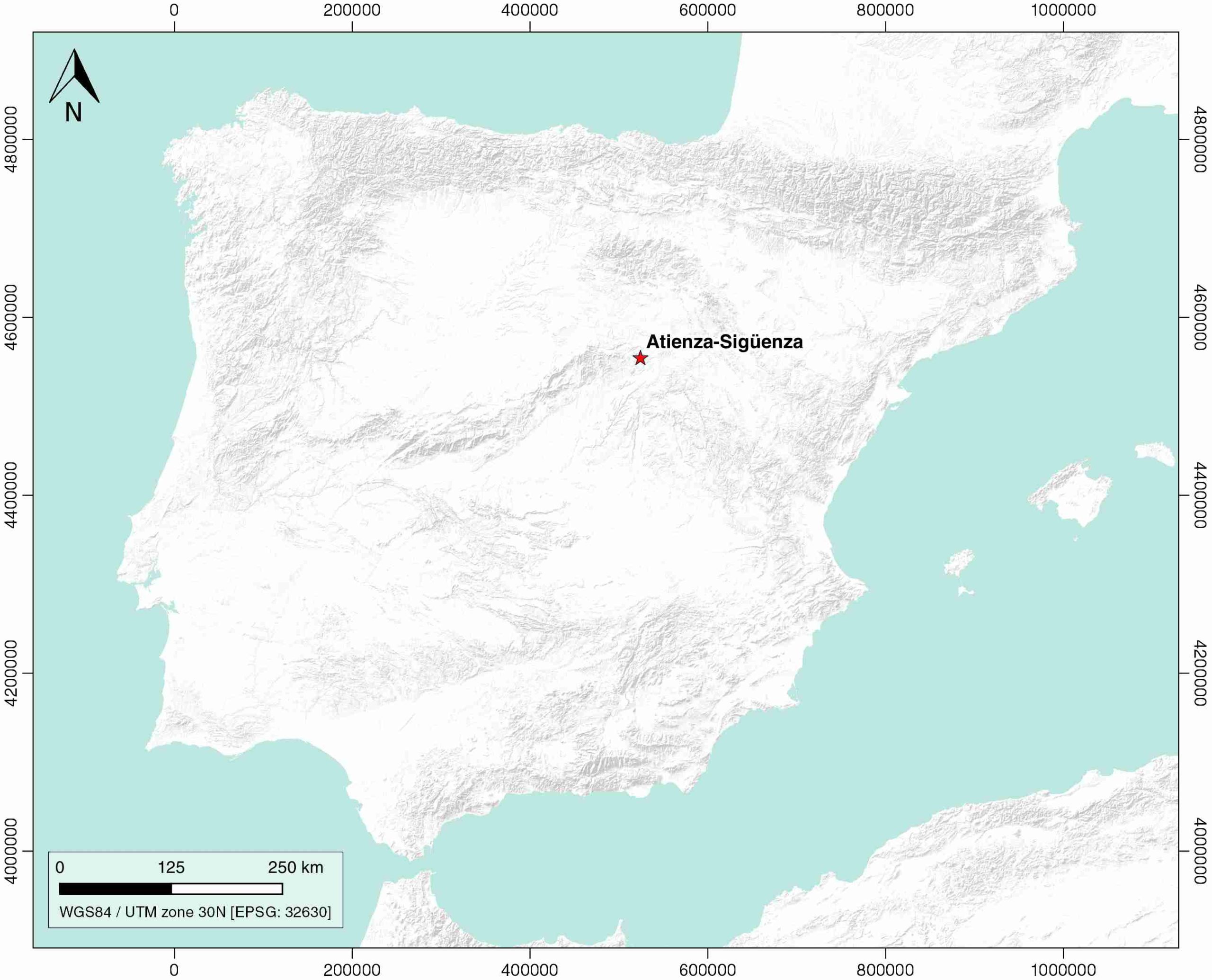
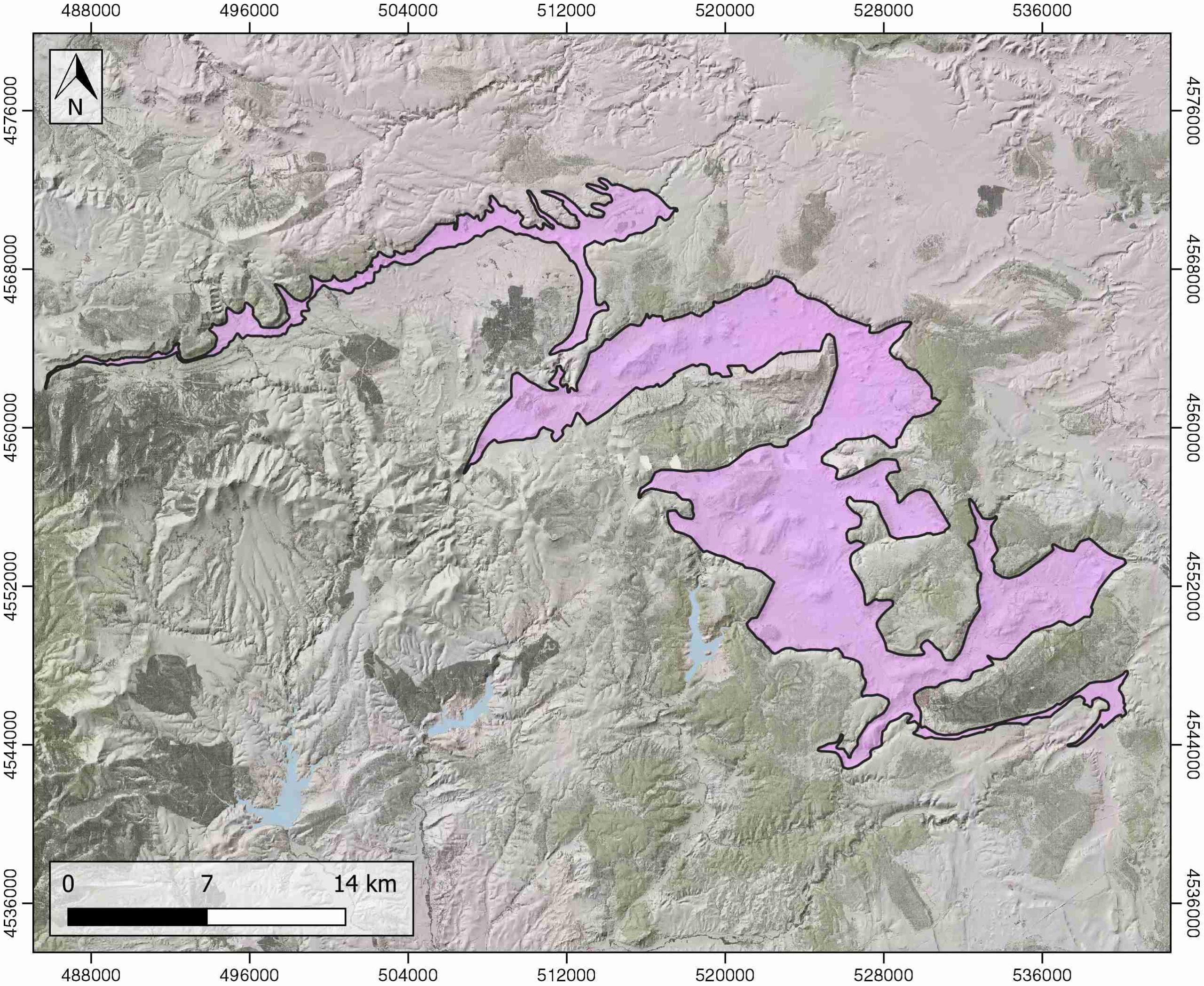
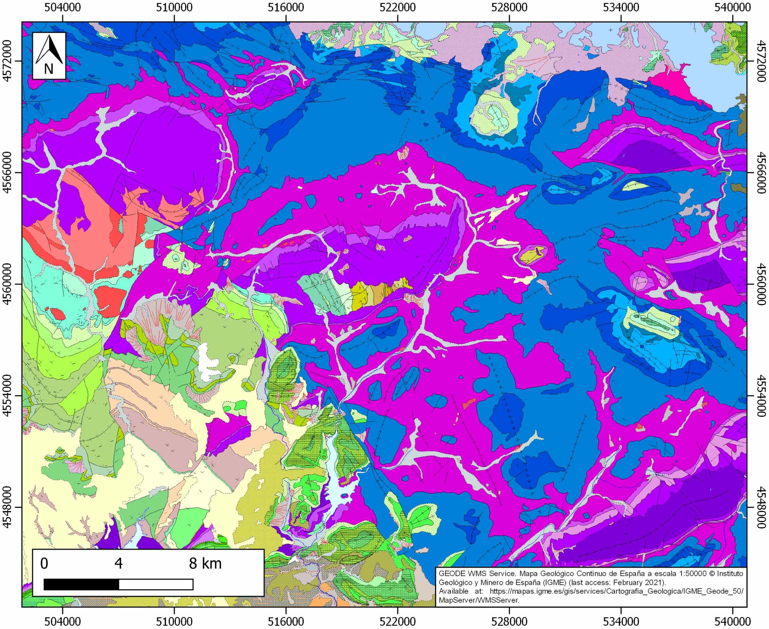
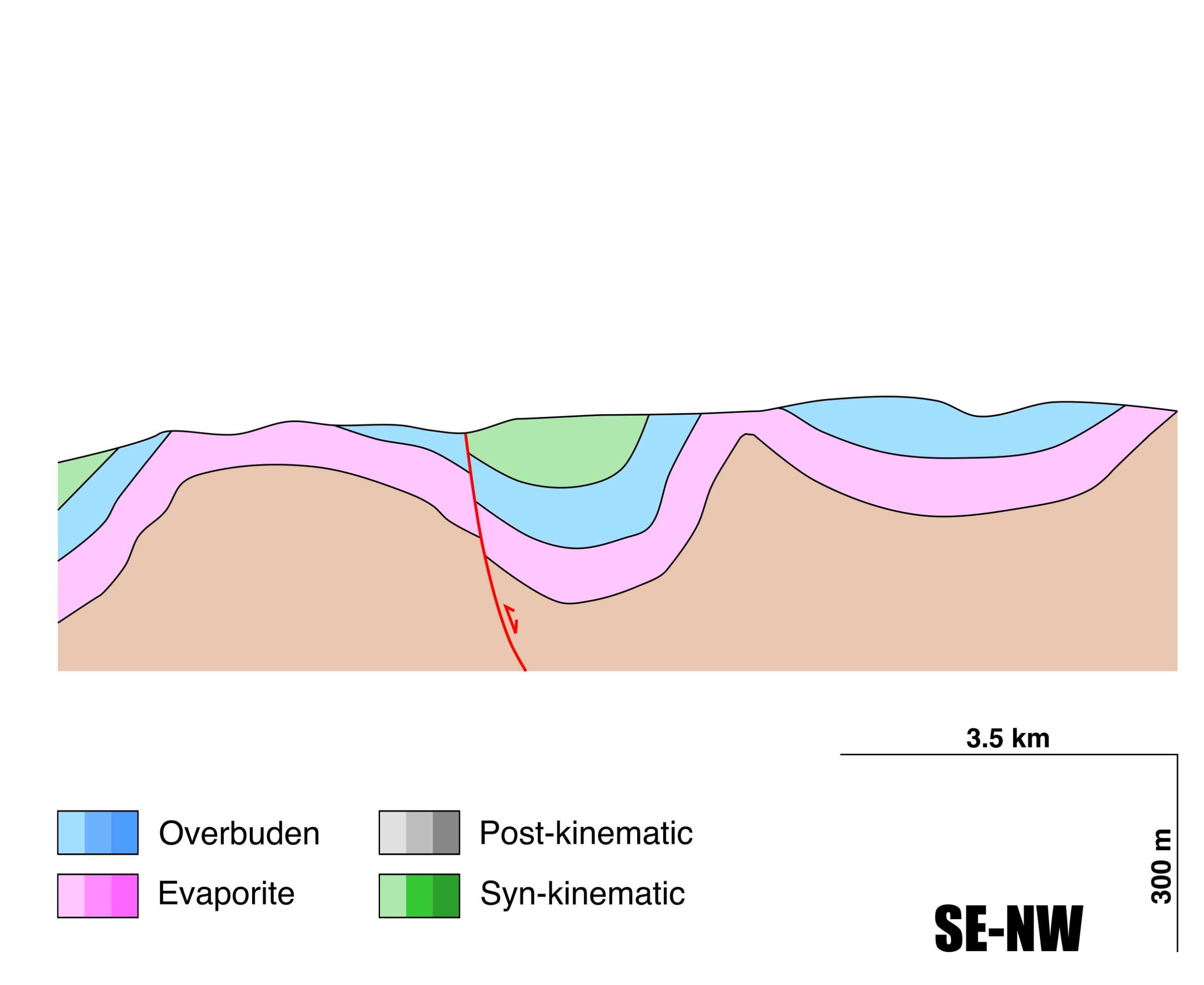
Atienza-Sigüenza
ID #114
General Information
| Structure type | Evaporite body |
| Deformed/Undeformed | Deformed |
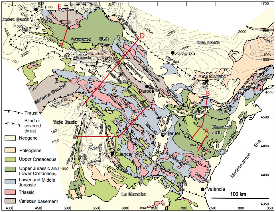
| Geological Setting | Castilian branch (Almanzán Basin), Iberian Range |
| Outcropping/buried | Outcropping |
| Evaporite unit/s name | Valderromán Fm. |
| Evaporite unit/s age | Carnian-Rhaetian (Upper Triassic) |
| Evaporite unit/s origin | Marine |
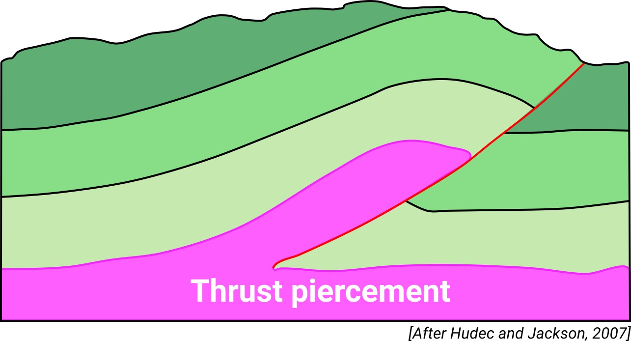
| Classif. (Hudec and Jackson, 2009) | Thrust piercement |
| Classif. (Jackson and Talbot, 1986) | |
| Age of evaporite flow or deformation (when deformed) | Oligocene to Miocene |
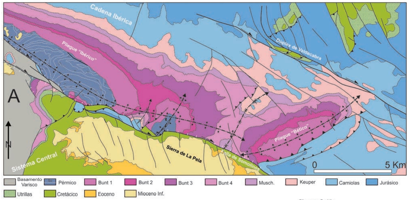
| Other comments | Cenozoic simultaneous development of "Iberian" (NW-SE) and "Betic" (NE-SW) folds. |
Generic Data
| Unique ID | 114 |
| Name | Atienza-Sigüenza |
| Structure type | Evaporite body |
| Deformed/Undeformed | Deformed |
| Buried/Outcropping | Outcropping |
| Geological setting | Iberian Range |
| Geological Regional Setting | Castilian branch (Almanzán Basin) |
| Evaporite unit/s name | Valderromán Fm. |
| Evaporite unit/s age | Carnian-Rhaetian (Upper Triassic) |
| Evaporite unit/s era | Mesozoic |
| Evaporite unit/s origin | Marine |
| Evaporite unit/s composition | Shale-Sandstone-Gypsum |
| Post-kinematic unit/s (or post-evaporite units when evaporites are undeformed) | Mid-Upper Miocene (sandstones and conglomerates) ; Pliocene (limestones and marly limestones) ; Quaternary (alluvial and colluvial detrital deposits) |
| Post-kinematic unit/s age (or post-evaporite units when evaporites are undeformed) | Mid Miocene-Holocene |
| Classification (Hudec and Jackson, 2009) | Thrust piercement |
| Classification (Jackson and Talbot, 1986) | |
| Mining activity? | Y |
| Mining activity start | |
| Mining activity end | Active |
| Mining galleries? | Y |
| Mining products | Halite |
| Mining sub-products | |
| Evaporite flow? | Y |
| Age of evaporite flow | Oligocene – Early Miocene |
| Flow or deformation triggering mechanisms | Tectonic inversion and strike-slip displacement of the Somolinos fault |
| Flow-linked structures? | Y |
| Halokinetic structures | Triangle zone development / thrust faults / progressive unconformities / thickness variations |
| Post-evaporite and pre-kinematic unit/s (overbuden) | Lower Jurassic (Cortes de Tajuña and Cuevas Labradas Fms., «carniolas», limestones and dolostones) ; Lower Jurassic (Cerro del Pez and Barahona Fms., limestones, dolostones and grey marlstones) ; Upper Jurassic (Turmiel and Chelva Fms., marlstones, marly limestones, oolitic limestones and laminated limestones) ; Mid Cretaceous (Utrillas Fm., sandstones and claystones) ; Upper Cretaceous (Moral de Hormuez, Caballar and Castrojimeno Fms., limestones, dolostones, marlstones, marly limestones) |
| Syn-kinematic unit/s | Early Miocene (red claystone, shales, sandstones, calcareous brecchias and conglomerates) |
| Available seismic profiles | ILIHA X-A |
| Available boreholes | ATIENZA-4 / ATIENZA-5 / ATIENZA-2 / ATIENZA-3 / ATIENZA-9 / ATIENZA-6 / ATIENZA-7 |
| Additional comments | Cenozoic simultaneous development of «Iberian» (NW-SE) and «Betic» (NE-SW) folds |
Mining Data
| UNIQUE_ID | 114 |
| Minning exploitations within <2km? | Y |
| Historical/Active | Historical (not indexed in the Spanish National Minning Cadastre) |
| Exploitation name #1 | Salinas de Imón |
| Exploitation ID (Spanish National Mining Cadastre) #1 | n.a. |
| Municipality #1 | Imón |
| Province #1 | Guadalajara |
| Company #1 | n.a. |
| Main minning Products #1 | Halite |
| Exploitation name #2 | |
| Exploitation ID (Spanish National Mining Cadastre) #2 | |
| Municipality #2 | |
| Province #2 | |
| Company #2 | |
| Main minning Products #2 | |
| Exploitation name #3 | |
| Exploitation ID (Spanish National Mining Cadastre) #3 | |
| Municipality #3 | |
| Province #3 | |
| Company #3 | |
| Main minning Products #3 |
Quantitative Data
| UNIQUE_ID | 114 |
| Outcropping area (km2) | 245.01341 |
| Horizontal intersection area (km2) (when buried) | Not buried |
| Depth of intersection area (km2) (when buried) | Not buried |
| Max. Width (Km) | 24.0547315 |
| Max. Length (Km) | 57.006279 |
| Max. Evaporites thickness (km) | |
| Max. Deformation age (Ma) | 34 |
| Min. Deformation age (Ma) | 20 |
| Deformation stages | 1 |
Reference Data
| UNIQUE_ID | 114 |
| Section source | De Vicente, G., Vegas, R., Muñoz-Martín, A., Van Wees, J. D., Casas-Sáinz, A., Sopeña, A., …, Fernández-Lozano, J., 2009. Oblique strain partitioning and transpression on an inverted rift: The Castilian Branch of the Iberian Chain. Tectonophysics, 470(3-4), 224-242. [link] |
| Well / Borehole availability #1 | n.a. |
| Well / Borehole availability #2 | n.a. |
| Available data (Stratigraphy) #1 | Aracil, E., Hernando, S., 1988. Las facies Keuper al SW de la provincia de Soria. Estudios Geológicos, 44(3-4), 211-217. [link] |
| Available data (Stratigraphy) #2 | Casas-Sainz, A., Cortés-Gracia, M. A., Maestro González, A., 2000. Intraplate deformation and basin formation during the Tertiary within the northern Iberian plate: Origin and evolution of the Almazán Basin. Tectonics, 19(2), 258-289. [link] |
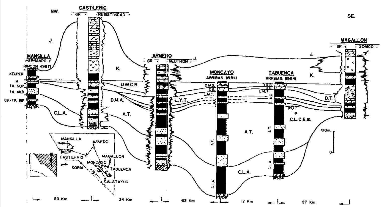
| Available data (Stratigraphy) #3 | Muñoz, A., Ramos, A., Sánchez Moya, Y., Sopeña, A., 1995. Caracterización de las unidades litoestrafigráficas del Triásico en el subsuelo del tercio noroccidental de la Cordillera Ibérica y áreas adyacentes. Cuadernos de Geología Ibérica, 19, 129-171. [link] |
| Available data (Stratigraphy) #4 | Guimerà, J., Mas, R., Alonso, Á., 2004. Intraplate deformation in the NW Iberian Chain: Mesozoic extension and Tertiary contractional inversion. Journal of the Geological Society, 161(2), 291-303. [link] |
| Available data (Stratigraphy) #5 | Muñoz, A., Ramos, A., Sopeña, A., Sánchez Moya, Y., 1992. Electrofacies en el Triásico del subsuelo de la Cuenca de Almazán. Geogaceta, 11, 26-30. [link] |
| Available data (Stratigraphy) #6 | n.a. |
| Regional Stratigraphy | Muñoz, A., Ramos, A., Sánchez Moya, Y., Sopeña, A., 1995. Caracterización de las unidades litoestrafigráficas del Triásico en el subsuelo del tercio noroccidental de la Cordillera Ibérica y áreas adyacentes. Cuadernos de Geología Ibérica, 19, 129-171. [link] |
| Seismic data availability #1 | Casas-Sainz, A., Cortés-Gracia, M. A., Maestro González, A., 2000. Intraplate deformation and basin formation during the Tertiary within the northern Iberian plate: Origin and evolution of the Almazán Basin. Tectonics, 19(2), 258-289. [link] |
| Seismic data availability #2 | De Vicente, G., Muñoz-Martín, A., 2013. The Madrid Basin and the Central System: A tectonostratigraphic analysis from 2D seismic lines. Tectonophysics, 602, 259-285. [link] |
| Seismic data availability #3 | Ruiz-Rivas, C., Lomba-Falcon, L., 2008. Favourable Formations for CO2 Storage in the Almazan Basin. Informes Técnicos Ciemat, 121pp. [link] |
| Available data (Structure) #1 | De Vicente, G., 2018. El registro geológico de las deformaciones alpinas en Iberia: Partición de la deformación o fases tectónicas. Revista de la Sociedad Geológica de España, 31(2), 13-22. [link] |
| Available data (Structure) #2 | García-Lasanta, C., Oliva-Urcia, B., Román-Berdiel, T., Casas, A. M., Gil-Peña, I., Sánchez-Moya, Y., …, Mattei, M., 2015. Evidence for the Permo-Triassic transtensional rifting in the Iberian Range (NE Spain) according to magnetic fabrics results. Tectonophysics, 651, 216-231. [link] |
| Available data (Structure) #3 | De Vicente, G., Vegas, R., Martín, A. M., Silva, P. G., Andriessen, P., Cloetingh, S. A. P. L., …, Olaiz, A., 2007. Cenozoic thick-skinned deformation and topography evolution of the Spanish Central System. Global and Planetary Change, 58(1-4), 335-381. [link] |
| Available data (Structure) #4 | Casas-Sainz, A., Cortés-Gracia, M. A., Maestro González, A., 2000. Intraplate deformation and basin formation during the Tertiary within the northern Iberian plate: Origin and evolution of the Almazán Basin. Tectonics, 19(2), 258-289. [link] |
| Available data (Structure) #5 | De Vicente, G., Muñoz-Martín, A., 2013. The Madrid Basin and the Central System: A tectonostratigraphic analysis from 2D seismic lines. Tectonophysics, 602, 259-285. [link] |
| Available data (Structure) #6 | Muñoz, A., Ramos, A., Sánchez Moya, Y., Sopeña, A., 1995. Caracterización de las unidades litoestrafigráficas del Triásico en el subsuelo del tercio noroccidental de la Cordillera Ibérica y áreas adyacentes. Cuadernos de Geología Ibérica, 19, 129-171. [link] |
| Available data (Analogue modelling) #1 | n.a. |
| Available data (Analogue modelling) #2 | n.a. |
| Available data (Analogue modelling) #3 | n.a. |
| Available data (Gravimetry – Tomography) #1 | Rey Moral, C., Gómez Ortiz, D., & Tejero López, R., 2000. Spectral analysis and gravity modelling of the Almazán basin (Central Spain). Revista de la Sociedad geológica de España, 13(1), 131-142. [link] |
| Available data (Gravimetry – Tomography) #2 | De Vicente, G., Vegas, R., Muñoz-Martín, A., Van Wees, J. D., Casas-Sáinz, A., Sopeña, A., …, Fernández-Lozano, J., 2009. Oblique strain partitioning and transpression on an inverted rift: The Castilian Branch of the Iberian Chain. Tectonophysics, 470(3-4), 224-242. [link] |
| Available data (Gravimetry – Tomography) #3 | De Vicente, G., Muñoz-Martín, A., 2013. The Madrid Basin and the Central System: A tectonostratigraphic analysis from 2D seismic lines. Tectonophysics, 602, 259-285. [link] |
| Available data (Geochemistry) #1 | n.a. |
| Available data (Geochemistry) #2 | n.a. |
| Available data (Geochemistry) #3 | n.a. |
| Available data (Geochemistry) #4 | n.a. |
| Available data (Petrophysics) #1 | Pueyo, E. L., Izquierdo-Llavall, E., Rodríguez-Pintó, A., Rey-Moral, C., Oliva-Urcia, B., Casas, A. M., …, García-Lobón, J. L. 2016. Petrophysical properties in the Iberian Range and surrounding areas (NE Spain): 1-density. Journal of Maps, 12(5), 836-844. [link] |
| Available data (Petrophysics) #2 | García-Lasanta, C., Oliva-Urcia, B., Román, T., Casas, A., Hirt, A. M., Villalaín, J., …, Sopeña, A., 2012. Paleomagnetism applied to basin geometry reconstruction in the Triassic red beds of the Castilian Branch (Iberian Range, NE Spain). Contributions to Geophysics and Geodesy, Spacial Issue. [link] |
| IGME Geological Map (MAGNA50) Sheet number | 461-Sigüenza. [link] and 434-Barahona. [link] and 433-Atienza. [link] |
| Other Maps #1 (source) | Guimerà, J. J., 2018. Structure of an intraplate fold-and-thrust belt: The Iberian Chain. A synthesis. Geologica Acta, 16(4), 427-438. [link] |
| Other Maps #2 (source) | De Vicente, G., 2018. El registro geológico de las deformaciones alpinas en Iberia: Partición de la deformación o fases tectónicas. Revista de la Sociedad Geológica de España, 31(2), 13-22. [link] |
| Other related references #1 | De Vicente, G., Vegas, R., Martín, A. M., Silva, P. G., Andriessen, P., Cloetingh, S. A. P. L., …, Olaiz, A., 2007. Cenozoic thick-skinned deformation and topography evolution of the Spanish Central System. Global and Planetary Change, 58(1-4), 335-381. [link] |
| Other related references #2 | Berrezueta, E., González-Menéndez, L., Breitner, D., Luquot, L., 2013. Pore system changes during experimental CO2 injection into detritic rocks: Studies of potential storage rocks from some sedimentary basins of Spain. International Journal of Greenhouse Gas Control, 17, 411-422. [link] |
| Other related references #3 | García-Lasanta, C., Oliva-Urcia, B., Román-Berdiel, T., Casas-Sainz, A., Gil-Peña, I., Sánchez-Moya, Y., Sopeña, A., 2012. Tectonically controlled magnetic fabrics in the Iberian Triassic basin. EGUGA, 8223. [link] |
| Other related references #4 | IGME, 2009. Plan de selección y caracterización de áreas y estructuras favorables para el almacenamiento geológico de CO2 en España. SID IGME database docs, (64.044). [link] |
Well and Seismic Data
| UNIQUE_ID | 114 |
| Seismic survey name #1 | ILIHA X-A |
| Across structure? #1 | N (within 3km) (withiN (within 3km) 3km) |
| Seismic profile ID (IGME) #1 | n.a. |
| Seismic profile code #1 | n.a. |
| Seismic profile name #1 | n.a. |
| Seismic survey year #1 | n.a. |
| Data repository #1 | SeisDARE Database: https://digital.csic.es/handle/10261/101990 |
| Length (km) #1 | 781.18 |
| Seismic survey name #2 | |
| Across structure? #2 | |
| Seismic profile ID (IGME) #2 | |
| Seismic profile code #2 | |
| Seismic profile name #2 | |
| Seismic survey year #2 | |
| Data repository #2 | |
| Length (km) #2 | |
| Seismic survey name #3 | |
| Across structure? #3 | |
| Seismic profile ID (IGME) #3 | |
| Seismic profile code #3 | |
| Seismic profile name #3 | |
| Seismic survey year #3 | |
| Data repository #3 | |
| Length (km) #3 | |
| Seismic survey name #4 | |
| Across structure? #4 | |
| Seismic profile ID (IGME) #4 | |
| Seismic profile code #4 | |
| Seismic profile name #4 | |
| Seismic survey year #4 | |
| Data repository #4 | |
| Length (km) #4 | |
| Seismic survey name #5 | |
| Across structure? #5 | |
| Seismic profile ID (IGME) #5 | |
| Seismic profile code #5 | |
| Seismic profile name #5 | |
| Seismic survey year #5 | |
| Data repository #5 | |
| Length (km) #5 | |
| Seismic survey name #6 | |
| Across structure? #6 | |
| Seismic profile ID (IGME) #6 | |
| Seismic profile code #6 | |
| Seismic profile name #6 | |
| Seismic survey year #6 | |
| Data repository #6 | |
| Length (km) #6 | |
| Seismic survey name #7 | |
| Across structure? #7 | |
| Seismic profile ID (IGME) #7 | |
| Seismic profile code #7 | |
| Seismic profile name #7 | |
| Seismic survey year #7 | |
| Data repository #7 | |
| Length (km) #7 | |
| Seismic survey name #8 | |
| Across structure? #8 | |
| Seismic profile ID (IGME) #8 | |
| Seismic profile code #8 | |
| Seismic profile name #8 | |
| Seismic survey year #8 | |
| Data repository #8 | |
| Length (km) #8 | |
| Seismic survey name #9 | |
| Across structure? #9 | |
| Seismic profile ID (IGME) #9 | |
| Seismic profile code #9 | |
| Seismic profile name #9 | |
| Seismic survey year #9 | |
| Data repository #9 | |
| Length (km) #9 | |
| Seismic survey name #10 | |
| Across structure? #10 | |
| Seismic profile ID (IGME) #10 | |
| Seismic profile code #10 | |
| Seismic profile name #10 | |
| Seismic survey year #10 | |
| Data repository #10 | |
| Length (km) #10 | |
| Seismic survey name #11 | |
| Across structure? #11 | |
| Seismic profile ID (IGME) #11 | |
| Seismic profile code #11 | |
| Seismic profile name #11 | |
| Seismic survey year #11 | |
| Data repository #11 | |
| Length (km) #11 | |
| Seismic survey name #12 | |
| Across structure? #12 | |
| Seismic profile ID (IGME) #12 | |
| Seismic profile code #12 | |
| Seismic profile name #12 | |
| Seismic survey year #12 | |
| Data repository #12 | |
| Length (km) #12 | |
| Seismic survey name #13 | |
| Across structure? #13 | |
| Seismic profile ID (IGME) #13 | |
| Seismic profile code #13 | |
| Seismic profile name #13 | |
| Seismic survey year #13 | |
| Data repository #13 | |
| Length (km) #13 | |
| Seismic survey name #14 | |
| Across structure? #14 | |
| Seismic profile ID (IGME) #14 | |
| Seismic profile code #14 | |
| Seismic profile name #14 | |
| Seismic survey year #14 | |
| Data repository #14 | |
| Length (km) #14 | |
| Seismic survey name #15 | |
| Across structure? #15 | |
| Seismic profile ID (IGME) #15 | |
| Seismic profile code #15 | |
| Seismic profile name #15 | |
| Seismic survey year #15 | |
| Data repository #15 | |
| Length (km) #15 | |
| Seismic survey name #16 | |
| Across structure? #16 | |
| Seismic profile ID (IGME) #16 | |
| Seismic profile code #16 | |
| Seismic profile name #16 | |
| Seismic survey year #16 | |
| Data repository #16 | |
| Length (km) #16 | |
| Seismic survey name #17 | |
| Across structure? #17 | |
| Seismic profile ID (IGME) #17 | |
| Seismic profile code #17 | |
| Seismic profile name #17 | |
| Seismic survey year #17 | |
| Data repository #17 | |
| Length (km) #17 | |
| Seismic survey name #18 | |
| Across structure? #18 | |
| Seismic profile ID (IGME) #18 | |
| Seismic profile code #18 | |
| Seismic profile name #18 | |
| Seismic survey year #18 | |
| Data repository #18 | |
| Length (km) #18 | |
| Seismic survey name #19 | |
| Across structure? #19 | |
| Seismic profile ID (IGME) #19 | |
| Seismic profile code #19 | |
| Seismic profile name #19 | |
| Seismic survey year #19 | |
| Data repository #19 | |
| Length (km) #19 | |
| Seismic survey name #20 | |
| Across structure? #20 | |
| Seismic profile ID (IGME) #20 | |
| Seismic profile code #20 | |
| Seismic profile name #20 | |
| Seismic survey year #20 | |
| Data repository #20 | |
| Length (km) #20 | |
| Seismic survey name #21 | |
| Across structure? #21 | |
| Seismic profile ID (IGME) #21 | |
| Seismic profile code #21 | |
| Seismic profile name #21 | |
| Seismic survey year #21 | |
| Data repository #21 | |
| Length (km) #21 | |
| Borehole name #1 | ATIENZA-4 |
| Company #1 | IGME |
| Traget #1 | INDUSTRIAL ROCKS |
| Across structure? #1 | N (within 5 km) |
| Borehole name #2 | ATIENZA-5 |
| Company #2 | IGME |
| Traget #2 | INDUSTRIAL ROCKS |
| Across structure? #2 | N (within 5 km) |
| Borehole name #3 | ATIENZA-2 |
| Company #3 | IGME |
| Traget #3 | INDUSTRIAL ROCKS |
| Across structure? #3 | N (within 5 km) |
| Borehole name #4 | ATIENZA-3 |
| Company #4 | IGME |
| Traget #4 | INDUSTRIAL ROCKS |
| Across structure? #4 | N (within 5 km) |
| Borehole name #5 | ATIENZA-9 |
| Company #5 | IGME |
| Traget #5 | INDUSTRIAL ROCKS |
| Across structure? #5 | N (within 5 km) |
| Borehole name #6 | ATIENZA-6 |
| Company #6 | IGME |
| Traget #6 | INDUSTRIAL ROCKS |
| Across structure? #6 | N (within 5 km) |
| Borehole name #7 | ATIENZA-7 |
| Company #7 | IGME |
| Traget #7 | INDUSTRIAL ROCKS |
| Across structure? #7 | N (within 5 km) |
| Borehole name #8 | |
| Company #8 | |
| Traget #8 | |
| Across structure? #8 | |
| Borehole name #9 | |
| Company #9 | |
| Traget #9 | |
| Across structure? #9 | |
| Borehole name #10 | |
| Company #10 | |
| Traget #10 | |
| Across structure? #10 | |
| Borehole name #11 | |
| Company #11 | |
| Traget #11 | |
| Across structure? #11 | |
| Borehole name #12 | |
| Company #12 | |
| Traget #12 | |
| Across structure? #12 | |
| Borehole name #13 | |
| Company #13 | |
| Traget #13 | |
| Across structure? #13 | |
| Borehole name #14 | |
| Company #14 | |
| Traget #14 | |
| Across structure? #14 | |
| Borehole name #15 | |
| Company #15 | |
| Traget #15 | |
| Across structure? #15 |
Geographical Data (EPSG:4326 - WGS 84)
| UNIQUE_ID | 114 |
| X Centroid (Structure shape) | -2.732966 |
| Y Centroid (Structure shape) | -2.732966 |
| Xmin (Structure shape) | -3.170981 |
| Xmax (Structure shape) | -2.519990 |
| Ymin (Structure shape) | 41.035819 |
| Ymax (Structure shape) | 41.304653 |
| Xmin seismic line #1 | -4.805725 |
| Xmax seismic line #1 | -2.410217 |
| Ymin seismic line #1 | 36.528503 |
| Ymax seismic line #1 | 43.318909 |
| Xmin seismic line #2 | |
| Xmax seismic line #2 | |
| Ymin seismic line #2 | |
| Ymax seismic line #2 | |
| Xmin seismic line #3 | |
| Xmax seismic line #3 | |
| Ymin seismic line #3 | |
| Ymax seismic line #3 | |
| Xmin seismic line #4 | |
| Xmax seismic line #4 | |
| Ymin seismic line #4 | |
| Ymax seismic line #4 | |
| Xmin seismic line #5 | |
| Xmax seismic line #5 | |
| Ymin seismic line #5 | |
| Ymax seismic line #5 | |
| Xmin seismic line #6 | |
| Xmax seismic line #6 | |
| Ymin seismic line #6 | |
| Ymax seismic line #6 | |
| Xmin seismic line #7 | |
| Xmax seismic line #7 | |
| Ymin seismic line #7 | |
| Ymax seismic line #7 | |
| Xmin seismic line #8 | |
| Xmax seismic line #8 | |
| Ymin seismic line #8 | |
| Ymax seismic line #8 | |
| Xmin seismic line #9 | |
| Xmax seismic line #9 | |
| Ymin seismic line #9 | |
| Ymax seismic line #9 | |
| Xmin seismic line #10 | |
| Xmax seismic line #10 | |
| Ymin seismic line #10 | |
| Ymax seismic line #10 | |
| Xmin seismic line #11 | |
| Xmax seismic line #11 | |
| Ymin seismic line #11 | |
| Ymax seismic line #11 | |
| Xmin seismic line #12 | |
| Xmax seismic line #12 | |
| Ymin seismic line #12 | |
| Ymax seismic line #12 | |
| Xmin seismic line #13 | |
| Xmax seismic line #13 | |
| Ymin seismic line #13 | |
| Ymax seismic line #13 | |
| Xmin seismic line #14 | |
| Xmax seismic line #14 | |
| Ymin seismic line #14 | |
| Ymax seismic line #14 | |
| Xmin seismic line #15 | |
| Xmax seismic line #15 | |
| Ymin seismic line #15 | |
| Ymax seismic line #15 | |
| Xmin seismic line #16 | |
| Xmax seismic line #16 | |
| Ymin seismic line #16 | |
| Ymax seismic line #16 | |
| Xmin seismic line #17 | |
| Xmax seismic line #17 | |
| Ymin seismic line #17 | |
| Ymax seismic line #17 | |
| Xmin seismic line #18 | |
| Xmax seismic line #18 | |
| Ymin seismic line #18 | |
| Ymax seismic line #18 | |
| Xmin seismic line #19 | |
| Xmax seismic line #19 | |
| Ymin seismic line #19 | |
| Ymax seismic line #19 | |
| Xmin seismic line #20 | |
| Xmax seismic line #20 | |
| Ymin seismic line #20 | |
| Ymax seismic line #20 | |
| Xmin seismic line #21 | |
| Xmax seismic line #21 | |
| Ymin seismic line #21 | |
| Ymax seismic line #21 | |
| X borehole #1 | -2.950331 |
| Y borehole #1 | 41.162549 |
| X borehole #2 | -2.963000 |
| Y borehole #2 | 41.164572 |
| X borehole #3 | -2.958363 |
| Y borehole #3 | 41.165516 |
| X borehole #4 | -2.948530 |
| Y borehole #4 | 41.162918 |
| X borehole #5 | -2.963916 |
| Y borehole #5 | 41.168076 |
| X borehole #6 | -2.963344 |
| Y borehole #6 | 41.167508 |
| X borehole #7 | -2.973493 |
| Y borehole #7 | 41.186176 |
| X borehole #8 | |
| Y borehole #8 | |
| X borehole #9 | |
| Y borehole #9 | |
| X borehole #10 | |
| Y borehole #10 | |
| X borehole #11 | |
| Y borehole #11 | |
| X borehole #12 | |
| Y borehole #12 | |
| X borehole #13 | |
| Y borehole #13 | |
| X borehole #14 | |
| Y borehole #14 | |
| X borehole #15 | |
| Y borehole #15 |

