General Information
| Structure type | Evaporite body |
| Deformed/Undeformed | Deformed |
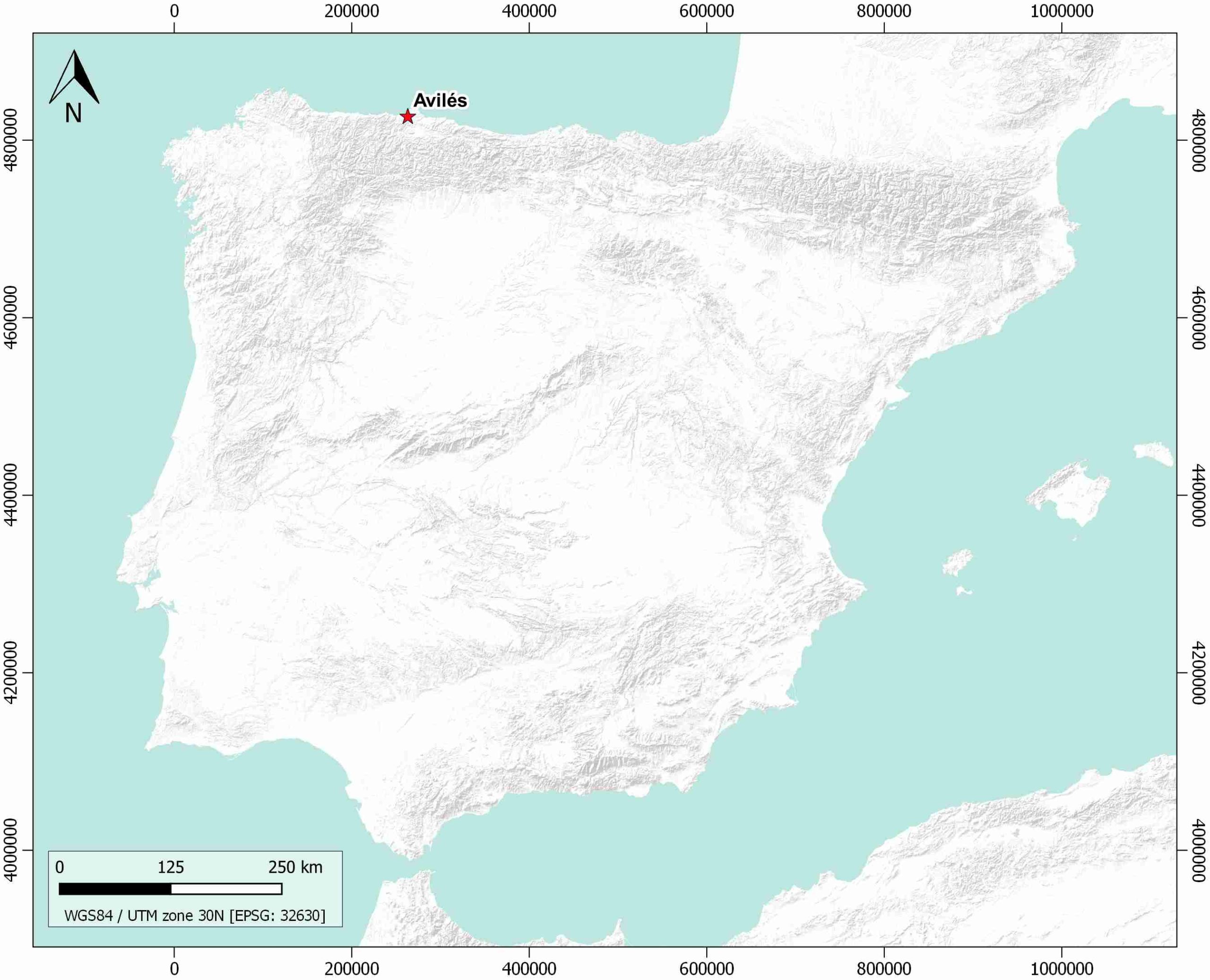
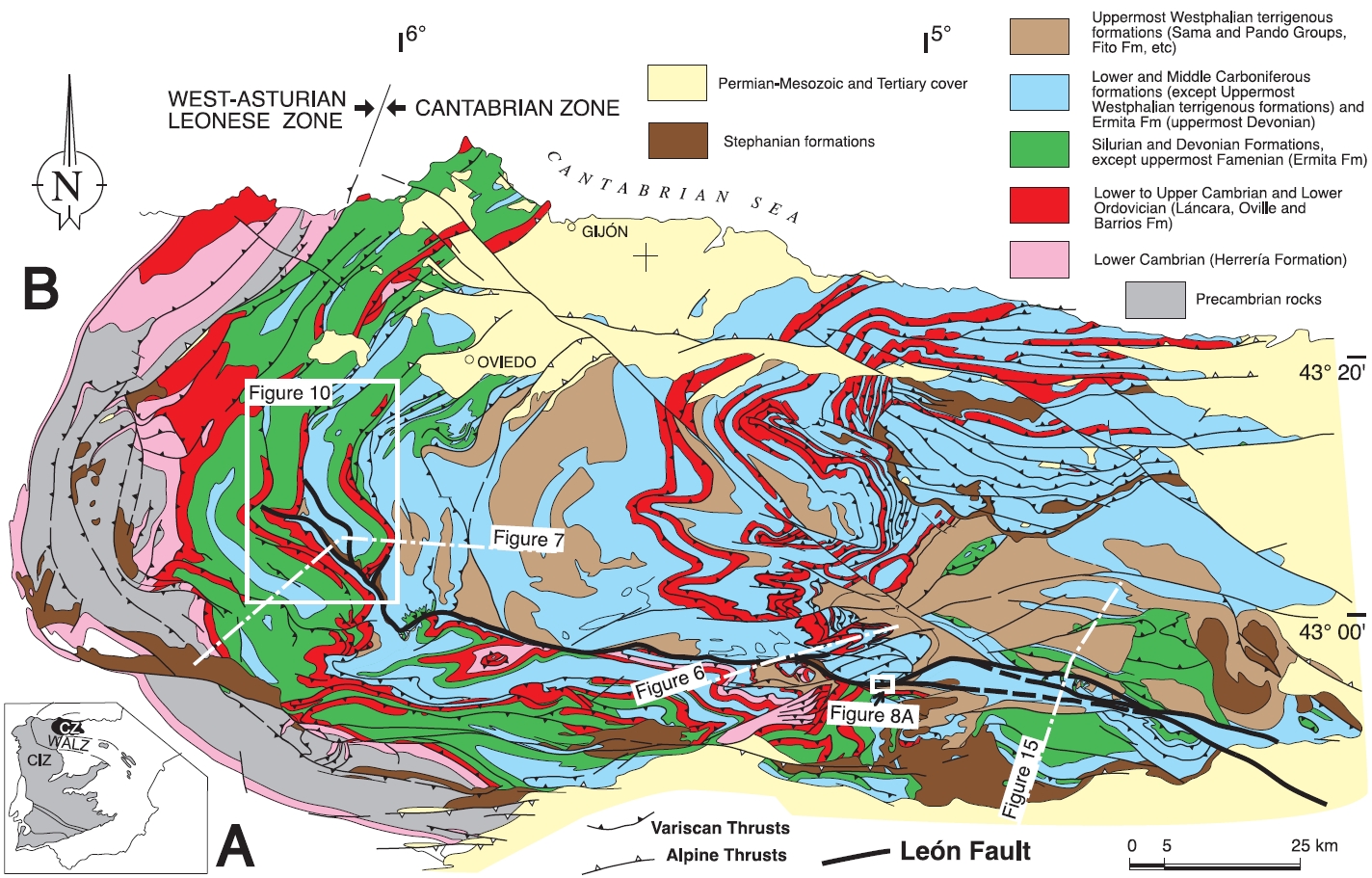
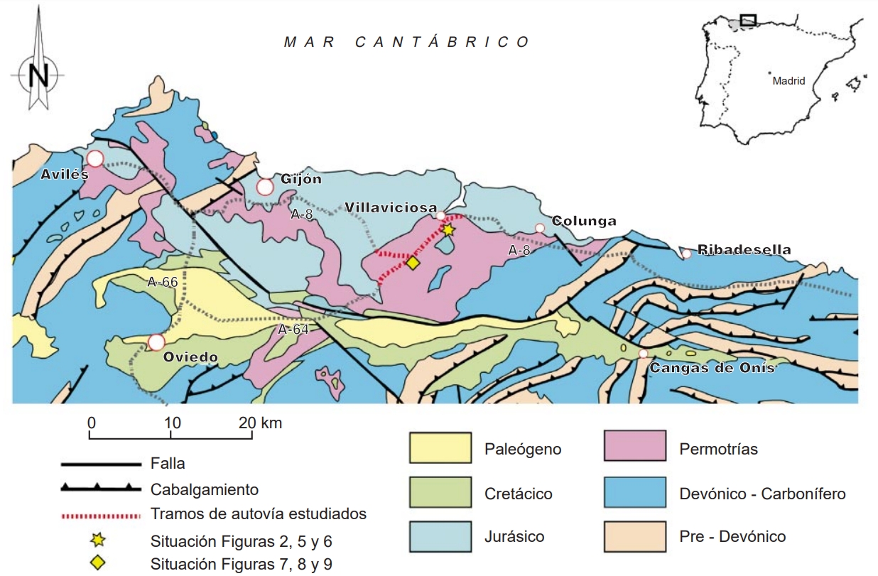
| Geological Setting | Iberian Massif (Asturian Basin) |
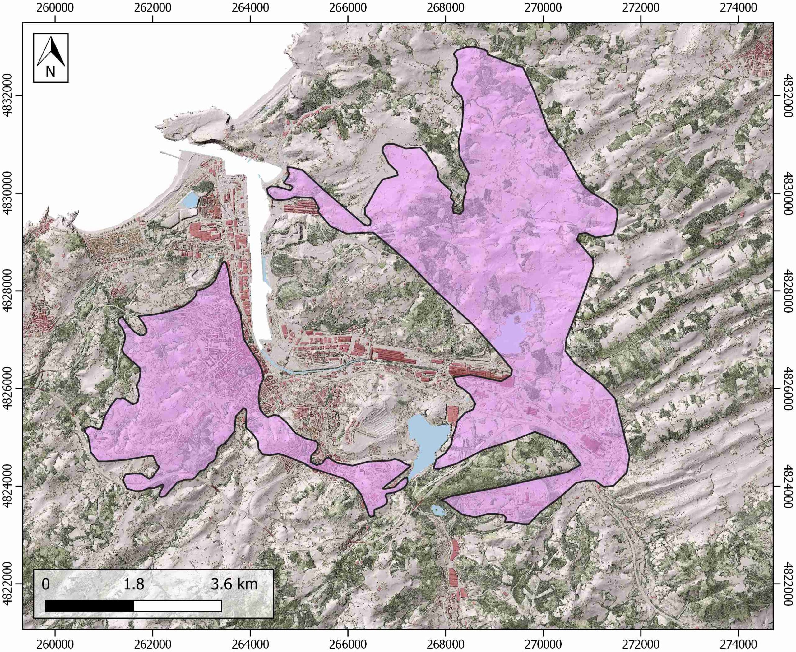
| Outcropping/buried | Outcropping |
| Evaporite unit/s name | Keuper facies, Middle Muschelkalk facies |
| Evaporite unit/s age | Upper Anisian and Carnian-Rhaetian (Middle-Upper Triassic) |
| Evaporite unit/s origin | Marine |
| Classif. (Hudec and Jackson, 2009) | No diapirism |
| Classif. (Jackson and Talbot, 1986) | No diapirism |
| Age of evaporite flow or deformation (when deformed) | Upper Jurassic |
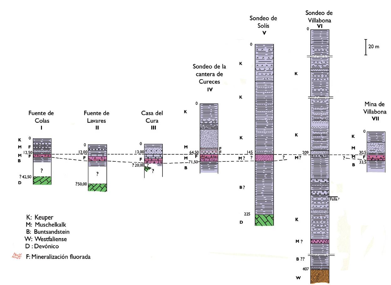
| Other comments | Diapirism in the Asturian basin have been only identified offshore, whereas in onshore evaporites are only related to extensional faults and the Mesozoic cover is undetached. Anhydrite found in the sub-surface (see Manjón and Gutiérrez-Claverol, 1991). |
Generic Data
| Unique ID | 134 |
| Name | Avilés |
| Structure type | Evaporite body |
| Deformed/Undeformed | Deformed |
| Buried/Outcropping | Outcropping |
| Geological setting | Iberian Massif |
| Geological Regional Setting | Asturian Basin |
| Evaporite unit/s name | Middle Muschelkalk and Keuper Facies |
| Evaporite unit/s age | Upper Anisian and Carnian-Rhaetian (Middle-Upper Triassic) |
| Evaporite unit/s era | Mesozoic |
| Evaporite unit/s origin | Marine |
| Evaporite unit/s composition | Sandstones-Gypsum-Red Claystonestone -Anhydrite |
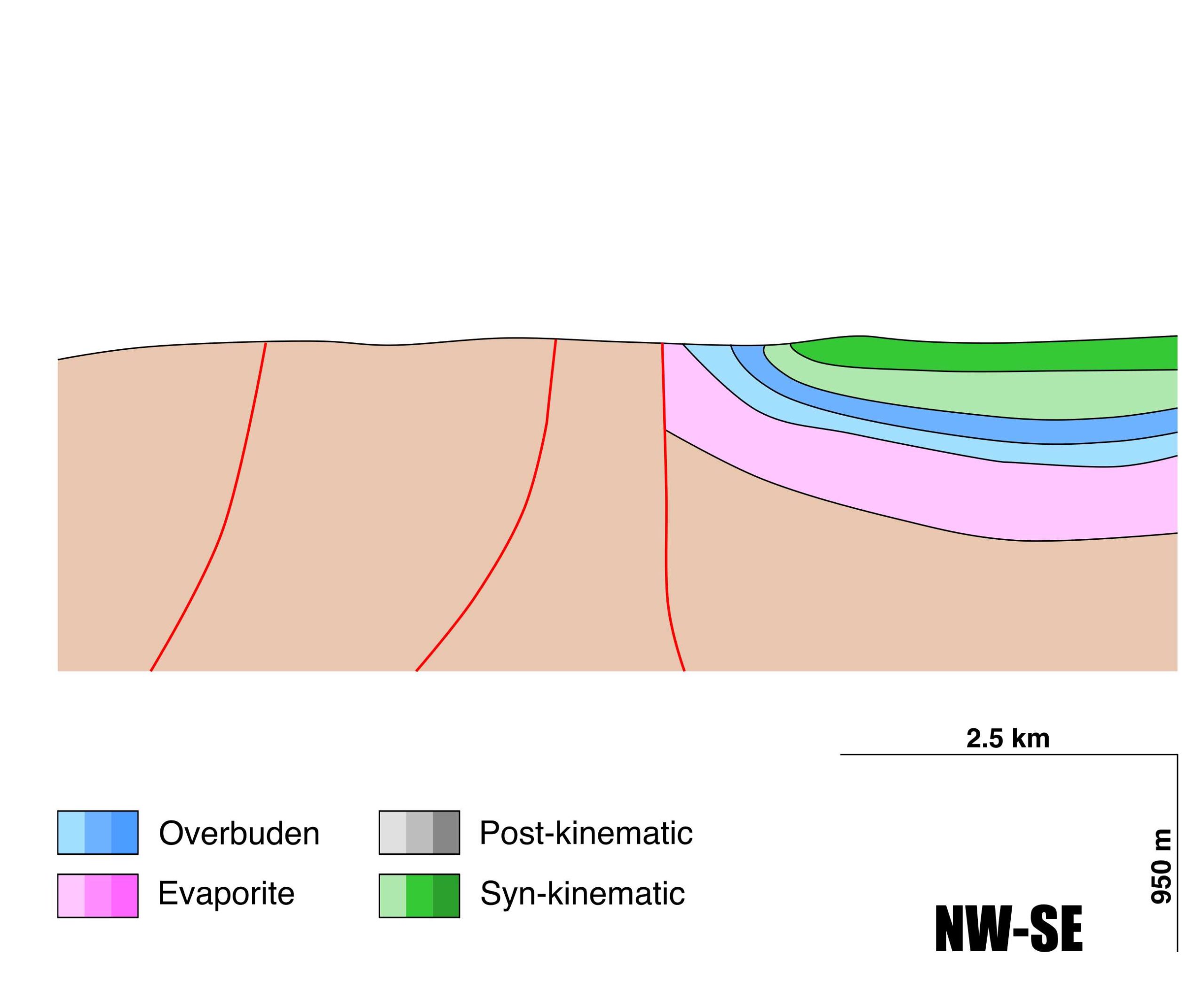
| Post-kinematic unit/s (or post-evaporite units when evaporites are undeformed) | Lower Cretaceous (Barremian-Albian, Carbonatic conglomerates, limestones, limestones, sandstones and shales) ; Upper Cretaceous (Cenomanian-Santonian, limestones, dolostones, marlstones and marly limestones) ; Paleogene (conglomerates, marlstones and sandstones) ; Quaternary (alluvial and colluvial detrital deposits) |
| Post-kinematic unit/s age (or post-evaporite units when evaporites are undeformed) | Lower Cretaceous-Holocene |
| Classification (Hudec and Jackson, 2009) | No diapirism |
| Classification (Jackson and Talbot, 1986) | No diapirism |
| Mining activity? | Y |
| Mining activity start | – |
| Mining activity end | – |
| Mining galleries? | – |
| Mining products | Gravel and sand |
| Mining sub-products | – |
| Evaporite flow? | Y |
| Age of evaporite flow | Late Jurassic (Kimmeridgian?) |
| Flow or deformation triggering mechanisms | Extensional faulting processes which preceded the opening of the Bay of Biscay |
| Flow-linked structures? | Y |
| Halokinetic structures | Normal faulting / Fractures / Basin compartmentalization / Thickness variations |
| Post-evaporite and pre-kinematic unit/s (overbuden) | Lower Jurassic (limestones, dolostones and black shales) ; Late Lower Jurassic (limestones, marlstones and shales) ; Middle Jurassic (Conglomerates and sandstones) |
| Syn-kinematic unit/s | Late Jurassic (limestones, marly limestones, claystones and sandstones) |
| Available seismic profiles | |
| Available boreholes | |
| Additional comments | Diapirism in the Asturian basin have been only identified offshore, whereas in onshore evaporites are only related to extensional faults and the Mesozoic cover is undetached. Anhydrite found in the sub-surface (see Manjón and Gutiérrez-Claverol, 1991). |
Mining Data
| UNIQUE_ID | 134 |
| Minning exploitations within <2km? | Y |
| Historical/Active | Active |
| Exploitation name #1 | RECUESTO |
| Exploitation ID (Spanish National Mining Cadastre) #1 | 1410 |
| Municipality #1 | Gozón |
| Province #1 | ASTURIAS |
| Company #1 | ASTURIANA DE MAQUINARIA, SA |
| Main minning Products #1 | Gravel and sand |
| Exploitation name #2 | LA ATALAYA |
| Exploitation ID (Spanish National Mining Cadastre) #2 | 947-b |
| Municipality #2 | Avilés |
| Province #2 | ASTURIAS |
| Company #2 | CANTERAS LA ATALAYA, SL |
| Main minning Products #2 | Gravel and sand |
| Exploitation name #3 | LA CASONA |
| Exploitation ID (Spanish National Mining Cadastre) #3 | 1393 |
| Municipality #3 | Avilés |
| Province #3 | ASTURIAS |
| Company #3 | CANTERAS LA ATALAYA, SL |
| Main minning Products #3 | Gravel and sand |
Quantitative Data
| UNIQUE_ID | 134 |
| Outcropping area (km2) | 36.61847 |
| Horizontal intersection area (km2) (when buried) | Not buried |
| Depth of intersection area (km2) (when buried) | Not buried |
| Max. Width (Km) | 11.7663034 |
| Max. Length (Km) | 9.1682923 |
| Max. Evaporites thickness (km) | 0.4 |
| Max. Deformation age (Ma) | 157 |
| Min. Deformation age (Ma) | 152 |
| Deformation stages | 1 |
Reference Data
| UNIQUE_ID | 134 |
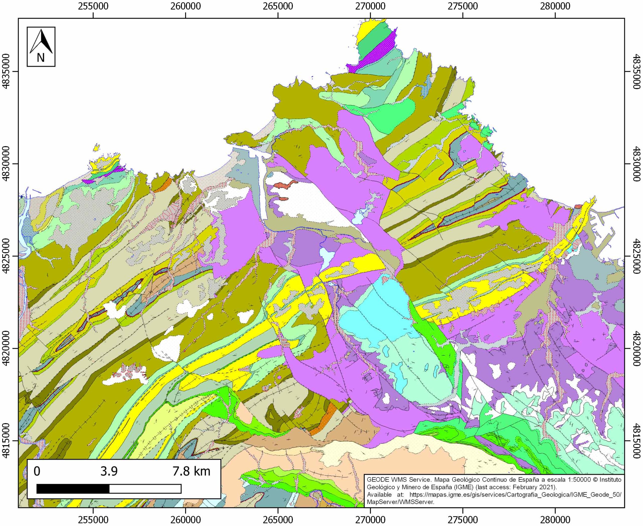
| Section source | IGME MAGNA 50. SHEET 14 (AVILÉS) |
| Well / Borehole availability #1 | n.a. |
| Well / Borehole availability #2 | n.a. |
| Available data (Stratigraphy) #1 | Luque Cabal, C., Gutiérrez Claverol, M., Pando, L., 2011. Contribución de la geología minera al conocimiento de la cuenca permotriásica asturiana. Trabajos De Geología, 30(30). [link] |
| Available data (Stratigraphy) #2 | Claverol, M. G., Fernández, B. G., Casares, E. M., García-Ramos, J. C., 2004. Litoestratigráfica del sector occidental de la cuenca cretácica de Asturias. Trabajos de Geología, (24), 43-80. [link] |
| Available data (Stratigraphy) #3 | Lepvrier, C., Martínez-García, E., 1990. Fault development and stress evolution of the post-Hercynian Asturian Basin (Asturias and Cantabria, northwestern Spain). Tectonophysics, 184(3-4), 345-356. [link] |
| Available data (Stratigraphy) #4 | López-Gómez, J., Martín-González, F., Heredia, N., de la Horra, R., Barrenechea, J. F., Cadenas, P., …, Gand, G., 2019. New lithostratigraphy for the Cantabrian Mountains: A common tectono-stratigraphic evolution for the onset of the Alpine cycle in the W Pyrenean realm, N Spain. Earth-Science Reviews, 188, 249-271. [link] |
| Available data (Stratigraphy) #5 | Mouterde, M. R., Suárez Vega, L. C., Virgili, C., 1977. Sobre el límite triásico-jurásico en Asturias (Noroeste de España). Cuadernos de Geología Ibérica, 4, 325-328. [link] |
| Available data (Stratigraphy) #6 | Martínez García, E., Coquel, R., Gutiérrez Claverol, M., Quiroga, J. L., . Edad del» tramo de transición» entre el Pérmico y el Jurásico en el área de Gijón (Asturias, NW de España). Geogaceta, 24, 215-218. [link] |
| Regional Stratigraphy | Luque Cabal, C., Gutiérrez Claverol, M., Pando, L., 2011. Contribución de la geología minera al conocimiento de la cuenca permotriásica asturiana. Trabajos De Geología, 30(30). [link] |
| Seismic data availability #1 | n.a. |
| Seismic data availability #2 | n.a. |
| Seismic data availability #3 | n.a. |
| Available data (Structure) #1 | Luque Cabal, C., Gutiérrez Claverol, M., Pando, L., 2011. Contribución de la geología minera al conocimiento de la cuenca permotriásica asturiana. Trabajos De Geología, 30(30). [link] |
| Available data (Structure) #2 | Patac, I., 1932. ¿ Gijón, cuenca potásica?: estudio de un sondeo en Pinzales. Obras Monográficas, Madrid. [link] |
| Available data (Structure) #3 | López-Gómez, J., Martín-González, F., Heredia, N., de la Horra, R., Barrenechea, J. F., Cadenas, P., …, Gand, G., 2019. New lithostratigraphy for the Cantabrian Mountains: A common tectono-stratigraphic evolution for the onset of the Alpine cycle in the W Pyrenean realm, N Spain. Earth-Science Reviews, 188, 249-271. [link] |
| Available data (Structure) #4 | Lepvrier, C., Martínez-García, E., 1990. Fault development and stress evolution of the post-Hercynian Asturian Basin (Asturias and Cantabria, northwestern Spain). Tectonophysics, 184(3-4), 345-356. [link] |
| Available data (Structure) #5 | Carola, E., Tavani, S., Ferrer, O., Granado, P., Quintà, A., Butillé, M., Muñoz, J. A., 2013. Along-strike extrusion at the transition between thin-and thick-skinned domains in the Pyrenean Orogen (northern Spain). Geological Society, London, Special Publications, 377(1), 119-140. [link] |
| Available data (Structure) #6 | Pieren Pidal, A. P., Areces, J. L., Toraño, J., Martínez García, E., 1995. Estratigrafia y estructura de los materiales permotriásicos del sector Gijón-La Collada (Asturias). Cuadernos de geología ibérica, (19), 309-335. [link] |
| Available data (Analogue modelling) #1 | n.a. |
| Available data (Analogue modelling) #2 | n.a. |
| Available data (Analogue modelling) #3 | n.a. |
| Available data (Gravimetry – Tomography) #1 | Ayala, C., Bohoyo, F., Maestro, A., Reguera, M. I., Torne, M., Rubio, F., Fernández, M., García-Lobón, J. L., 2016. Updated Bouguer anomalies of the Iberian Peninsula: a new perspective to interpret the regional geology. Journal of Maps, 12(5), 1089-1092. [link] |
| Available data (Gravimetry – Tomography) #2 | n.a. |
| Available data (Gravimetry – Tomography) #3 | n.a. |
| Available data (Geochemistry) #1 | n.a. |
| Available data (Geochemistry) #2 | n.a. |
| Available data (Geochemistry) #3 | n.a. |
| Available data (Geochemistry) #4 | n.a. |
| Available data (Petrophysics) #1 | n.a. |
| Available data (Petrophysics) #2 | n.a. |
| IGME Geological Map (MAGNA50) Sheet number | 13-Avilés. [link] |
| Other Maps #1 (source) | Alosno, J. L., Marcos, A., Suárez, A., 2009. Paleogeographic inversion resulting from large out of sequence breaching thrusts: The León Fault (Cantabrian Zone, NW Iberia). A new picture of the external Variscan Thrust Belt in the Ibero-Armorican Arc. Geologica acta, 7(4), 0451-473. [link] |
| Other Maps #2 (source) | Pando González, L. A., López Fernández, C., Torres Alonso, M., Gutiérrez Claverol, M. A., 2005. Comportamiento geotécnico de los materiales lutíticos del Permotrías en Asturias. Trabajos de Geología, 25, 69-83. [link] |
| Other related references #1 | Manjón, M., Gutiérrez Claverol, M., 1991. Nuevas precisiones sobre los depósitos de sulfatos de los alrededores de Gijón (Asturias). Geogaceta, 9, 87-89. [link] |
| Other related references #2 | Cadenas, P., Fernández‐Viejo, G., 2017. The Asturian Basin within the North Iberian margin (Bay of Biscay): seismic characterisation of its geometry and its Mesozoic and Cenozoic cover. Basin Research, 29(4), 521-541. [link] |
| Other related references #3 | Fernández, B. G., Asensio, M. M., Casares, E. M., Claverol, M. G., 2006. Propuesta de declaración de Puntos de Interés Hidrogeológico en los acuíferos jurásicos de Gijón-Villaviciosa (Asturias): nacimiento del río España, nacimiento del río Peña de Francia, cueva del Lloviu y fuente de La Ruxidora. Trabajos de Geología, 26, 141-146. [link] |
| Other related references #4 | Claverol, M. G., Gallastegui, J., 2002. Prospección de hidrocarburos en la plataforma continental de Asturias. Trabajos de Geología, 23, 2-3. [link] |
Well and Seismic Data
| UNIQUE_ID | 134 |
| Seismic survey name #1 | |
| Across structure? #1 | |
| Seismic profile ID (IGME) #1 | |
| Seismic profile code #1 | |
| Seismic profile name #1 | |
| Seismic survey year #1 | |
| Data repository #1 | |
| Length (km) #1 | |
| Seismic survey name #2 | |
| Across structure? #2 | |
| Seismic profile ID (IGME) #2 | |
| Seismic profile code #2 | |
| Seismic profile name #2 | |
| Seismic survey year #2 | |
| Data repository #2 | |
| Length (km) #2 | |
| Seismic survey name #3 | |
| Across structure? #3 | |
| Seismic profile ID (IGME) #3 | |
| Seismic profile code #3 | |
| Seismic profile name #3 | |
| Seismic survey year #3 | |
| Data repository #3 | |
| Length (km) #3 | |
| Seismic survey name #4 | |
| Across structure? #4 | |
| Seismic profile ID (IGME) #4 | |
| Seismic profile code #4 | |
| Seismic profile name #4 | |
| Seismic survey year #4 | |
| Data repository #4 | |
| Length (km) #4 | |
| Seismic survey name #5 | |
| Across structure? #5 | |
| Seismic profile ID (IGME) #5 | |
| Seismic profile code #5 | |
| Seismic profile name #5 | |
| Seismic survey year #5 | |
| Data repository #5 | |
| Length (km) #5 | |
| Seismic survey name #6 | |
| Across structure? #6 | |
| Seismic profile ID (IGME) #6 | |
| Seismic profile code #6 | |
| Seismic profile name #6 | |
| Seismic survey year #6 | |
| Data repository #6 | |
| Length (km) #6 | |
| Seismic survey name #7 | |
| Across structure? #7 | |
| Seismic profile ID (IGME) #7 | |
| Seismic profile code #7 | |
| Seismic profile name #7 | |
| Seismic survey year #7 | |
| Data repository #7 | |
| Length (km) #7 | |
| Seismic survey name #8 | |
| Across structure? #8 | |
| Seismic profile ID (IGME) #8 | |
| Seismic profile code #8 | |
| Seismic profile name #8 | |
| Seismic survey year #8 | |
| Data repository #8 | |
| Length (km) #8 | |
| Seismic survey name #9 | |
| Across structure? #9 | |
| Seismic profile ID (IGME) #9 | |
| Seismic profile code #9 | |
| Seismic profile name #9 | |
| Seismic survey year #9 | |
| Data repository #9 | |
| Length (km) #9 | |
| Seismic survey name #10 | |
| Across structure? #10 | |
| Seismic profile ID (IGME) #10 | |
| Seismic profile code #10 | |
| Seismic profile name #10 | |
| Seismic survey year #10 | |
| Data repository #10 | |
| Length (km) #10 | |
| Seismic survey name #11 | |
| Across structure? #11 | |
| Seismic profile ID (IGME) #11 | |
| Seismic profile code #11 | |
| Seismic profile name #11 | |
| Seismic survey year #11 | |
| Data repository #11 | |
| Length (km) #11 | |
| Seismic survey name #12 | |
| Across structure? #12 | |
| Seismic profile ID (IGME) #12 | |
| Seismic profile code #12 | |
| Seismic profile name #12 | |
| Seismic survey year #12 | |
| Data repository #12 | |
| Length (km) #12 | |
| Seismic survey name #13 | |
| Across structure? #13 | |
| Seismic profile ID (IGME) #13 | |
| Seismic profile code #13 | |
| Seismic profile name #13 | |
| Seismic survey year #13 | |
| Data repository #13 | |
| Length (km) #13 | |
| Seismic survey name #14 | |
| Across structure? #14 | |
| Seismic profile ID (IGME) #14 | |
| Seismic profile code #14 | |
| Seismic profile name #14 | |
| Seismic survey year #14 | |
| Data repository #14 | |
| Length (km) #14 | |
| Seismic survey name #15 | |
| Across structure? #15 | |
| Seismic profile ID (IGME) #15 | |
| Seismic profile code #15 | |
| Seismic profile name #15 | |
| Seismic survey year #15 | |
| Data repository #15 | |
| Length (km) #15 | |
| Seismic survey name #16 | |
| Across structure? #16 | |
| Seismic profile ID (IGME) #16 | |
| Seismic profile code #16 | |
| Seismic profile name #16 | |
| Seismic survey year #16 | |
| Data repository #16 | |
| Length (km) #16 | |
| Seismic survey name #17 | |
| Across structure? #17 | |
| Seismic profile ID (IGME) #17 | |
| Seismic profile code #17 | |
| Seismic profile name #17 | |
| Seismic survey year #17 | |
| Data repository #17 | |
| Length (km) #17 | |
| Seismic survey name #18 | |
| Across structure? #18 | |
| Seismic profile ID (IGME) #18 | |
| Seismic profile code #18 | |
| Seismic profile name #18 | |
| Seismic survey year #18 | |
| Data repository #18 | |
| Length (km) #18 | |
| Seismic survey name #19 | |
| Across structure? #19 | |
| Seismic profile ID (IGME) #19 | |
| Seismic profile code #19 | |
| Seismic profile name #19 | |
| Seismic survey year #19 | |
| Data repository #19 | |
| Length (km) #19 | |
| Seismic survey name #20 | |
| Across structure? #20 | |
| Seismic profile ID (IGME) #20 | |
| Seismic profile code #20 | |
| Seismic profile name #20 | |
| Seismic survey year #20 | |
| Data repository #20 | |
| Length (km) #20 | |
| Seismic survey name #21 | |
| Across structure? #21 | |
| Seismic profile ID (IGME) #21 | |
| Seismic profile code #21 | |
| Seismic profile name #21 | |
| Seismic survey year #21 | |
| Data repository #21 | |
| Length (km) #21 | |
| Borehole name #1 | |
| Company #1 | |
| Traget #1 | |
| Across structure? #1 | |
| Borehole name #2 | |
| Company #2 | |
| Traget #2 | |
| Across structure? #2 | |
| Borehole name #3 | |
| Company #3 | |
| Traget #3 | |
| Across structure? #3 | |
| Borehole name #4 | |
| Company #4 | |
| Traget #4 | |
| Across structure? #4 | |
| Borehole name #5 | |
| Company #5 | |
| Traget #5 | |
| Across structure? #5 | |
| Borehole name #6 | |
| Company #6 | |
| Traget #6 | |
| Across structure? #6 | |
| Borehole name #7 | |
| Company #7 | |
| Traget #7 | |
| Across structure? #7 | |
| Borehole name #8 | |
| Company #8 | |
| Traget #8 | |
| Across structure? #8 | |
| Borehole name #9 | |
| Company #9 | |
| Traget #9 | |
| Across structure? #9 | |
| Borehole name #10 | |
| Company #10 | |
| Traget #10 | |
| Across structure? #10 | |
| Borehole name #11 | |
| Company #11 | |
| Traget #11 | |
| Across structure? #11 | |
| Borehole name #12 | |
| Company #12 | |
| Traget #12 | |
| Across structure? #12 | |
| Borehole name #13 | |
| Company #13 | |
| Traget #13 | |
| Across structure? #13 | |
| Borehole name #14 | |
| Company #14 | |
| Traget #14 | |
| Across structure? #14 | |
| Borehole name #15 | |
| Company #15 | |
| Traget #15 | |
| Across structure? #15 |
Geographical Data (EPSG:4326 - WGS 84)
| UNIQUE_ID | 134 |
| X Centroid (Structure shape) | -5.880417 |
| Y Centroid (Structure shape) | -5.880417 |
| Xmin (Structure shape) | -5.963175 |
| Xmax (Structure shape) | -5.824860 |
| Ymin (Structure shape) | 43.526379 |
| Ymax (Structure shape) | 43.614030 |
| Xmin seismic line #1 | |
| Xmax seismic line #1 | |
| Ymin seismic line #1 | |
| Ymax seismic line #1 | |
| Xmin seismic line #2 | |
| Xmax seismic line #2 | |
| Ymin seismic line #2 | |
| Ymax seismic line #2 | |
| Xmin seismic line #3 | |
| Xmax seismic line #3 | |
| Ymin seismic line #3 | |
| Ymax seismic line #3 | |
| Xmin seismic line #4 | |
| Xmax seismic line #4 | |
| Ymin seismic line #4 | |
| Ymax seismic line #4 | |
| Xmin seismic line #5 | |
| Xmax seismic line #5 | |
| Ymin seismic line #5 | |
| Ymax seismic line #5 | |
| Xmin seismic line #6 | |
| Xmax seismic line #6 | |
| Ymin seismic line #6 | |
| Ymax seismic line #6 | |
| Xmin seismic line #7 | |
| Xmax seismic line #7 | |
| Ymin seismic line #7 | |
| Ymax seismic line #7 | |
| Xmin seismic line #8 | |
| Xmax seismic line #8 | |
| Ymin seismic line #8 | |
| Ymax seismic line #8 | |
| Xmin seismic line #9 | |
| Xmax seismic line #9 | |
| Ymin seismic line #9 | |
| Ymax seismic line #9 | |
| Xmin seismic line #10 | |
| Xmax seismic line #10 | |
| Ymin seismic line #10 | |
| Ymax seismic line #10 | |
| Xmin seismic line #11 | |
| Xmax seismic line #11 | |
| Ymin seismic line #11 | |
| Ymax seismic line #11 | |
| Xmin seismic line #12 | |
| Xmax seismic line #12 | |
| Ymin seismic line #12 | |
| Ymax seismic line #12 | |
| Xmin seismic line #13 | |
| Xmax seismic line #13 | |
| Ymin seismic line #13 | |
| Ymax seismic line #13 | |
| Xmin seismic line #14 | |
| Xmax seismic line #14 | |
| Ymin seismic line #14 | |
| Ymax seismic line #14 | |
| Xmin seismic line #15 | |
| Xmax seismic line #15 | |
| Ymin seismic line #15 | |
| Ymax seismic line #15 | |
| Xmin seismic line #16 | |
| Xmax seismic line #16 | |
| Ymin seismic line #16 | |
| Ymax seismic line #16 | |
| Xmin seismic line #17 | |
| Xmax seismic line #17 | |
| Ymin seismic line #17 | |
| Ymax seismic line #17 | |
| Xmin seismic line #18 | |
| Xmax seismic line #18 | |
| Ymin seismic line #18 | |
| Ymax seismic line #18 | |
| Xmin seismic line #19 | |
| Xmax seismic line #19 | |
| Ymin seismic line #19 | |
| Ymax seismic line #19 | |
| Xmin seismic line #20 | |
| Xmax seismic line #20 | |
| Ymin seismic line #20 | |
| Ymax seismic line #20 | |
| Xmin seismic line #21 | |
| Xmax seismic line #21 | |
| Ymin seismic line #21 | |
| Ymax seismic line #21 | |
| X borehole #1 | |
| Y borehole #1 | |
| X borehole #2 | |
| Y borehole #2 | |
| X borehole #3 | |
| Y borehole #3 | |
| X borehole #4 | |
| Y borehole #4 | |
| X borehole #5 | |
| Y borehole #5 | |
| X borehole #6 | |
| Y borehole #6 | |
| X borehole #7 | |
| Y borehole #7 | |
| X borehole #8 | |
| Y borehole #8 | |
| X borehole #9 | |
| Y borehole #9 | |
| X borehole #10 | |
| Y borehole #10 | |
| X borehole #11 | |
| Y borehole #11 | |
| X borehole #12 | |
| Y borehole #12 | |
| X borehole #13 | |
| Y borehole #13 | |
| X borehole #14 | |
| Y borehole #14 | |
| X borehole #15 | |
| Y borehole #15 |

