General Information
| Structure type | Evaporite body |
| Deformed/Undeformed | Deformed |
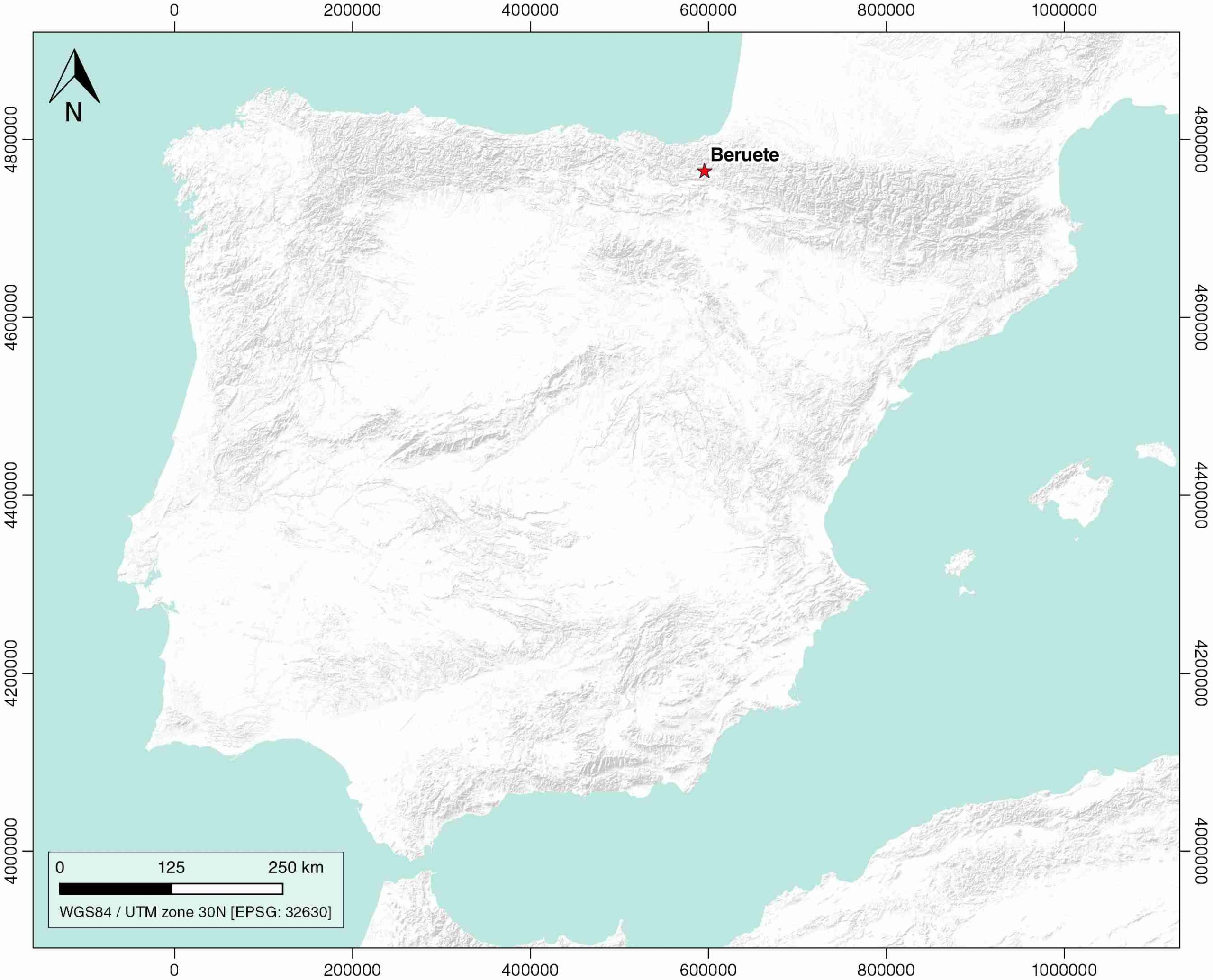
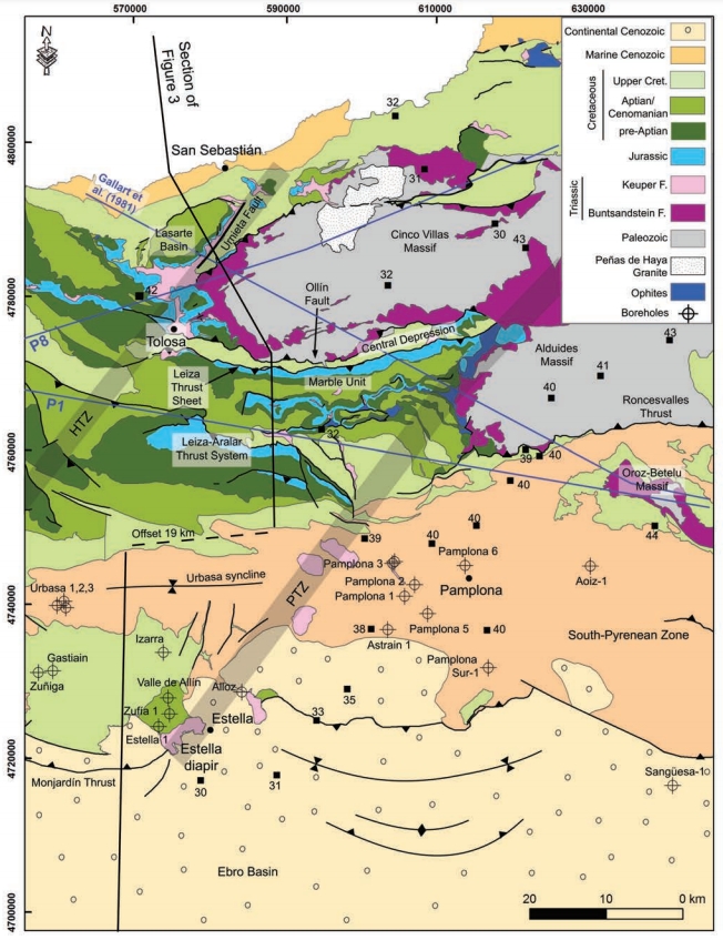
| Geological Setting | Basque Arc, Basque-Cantabrian Basin |
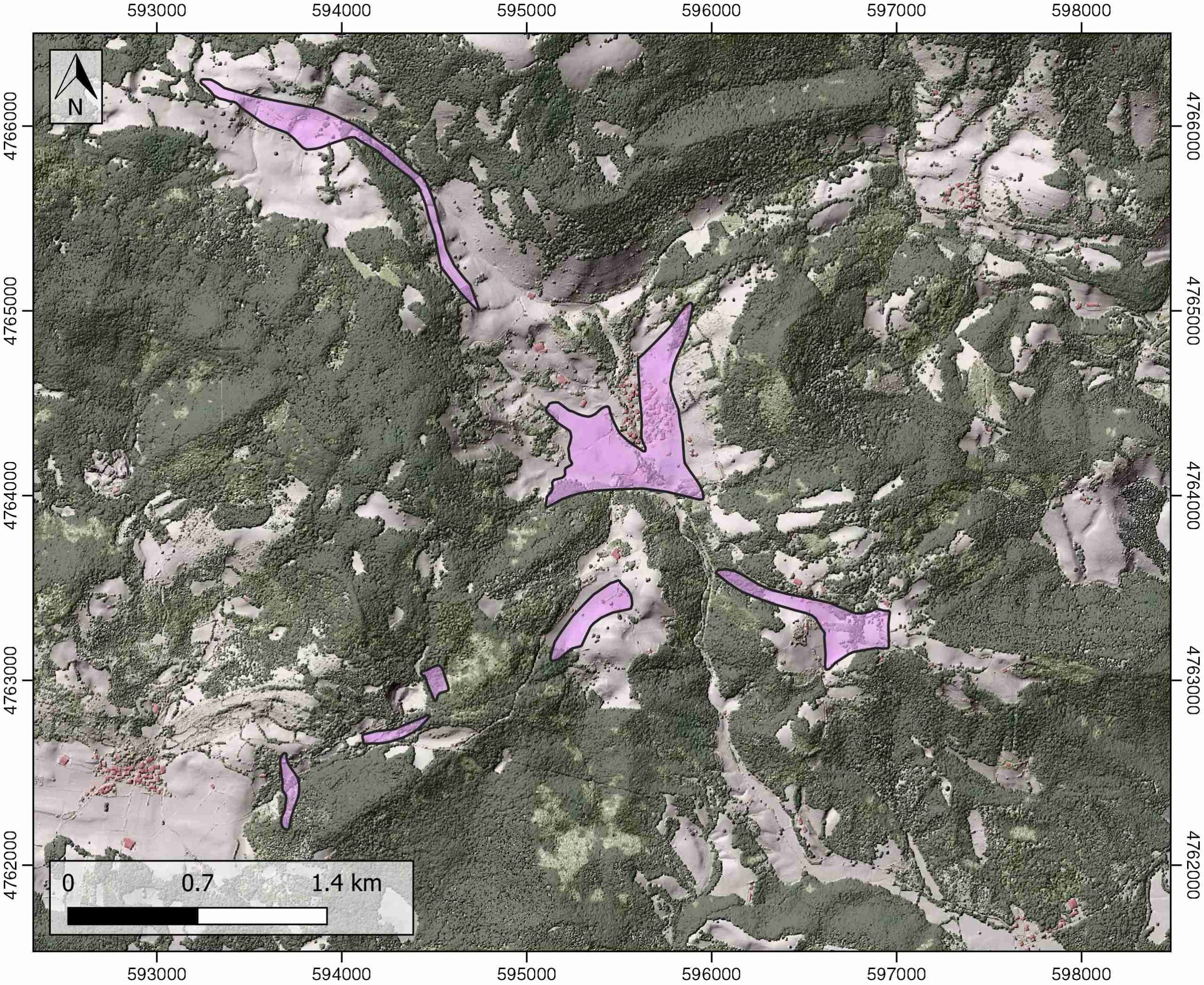
| Outcropping/buried | Outcropping |
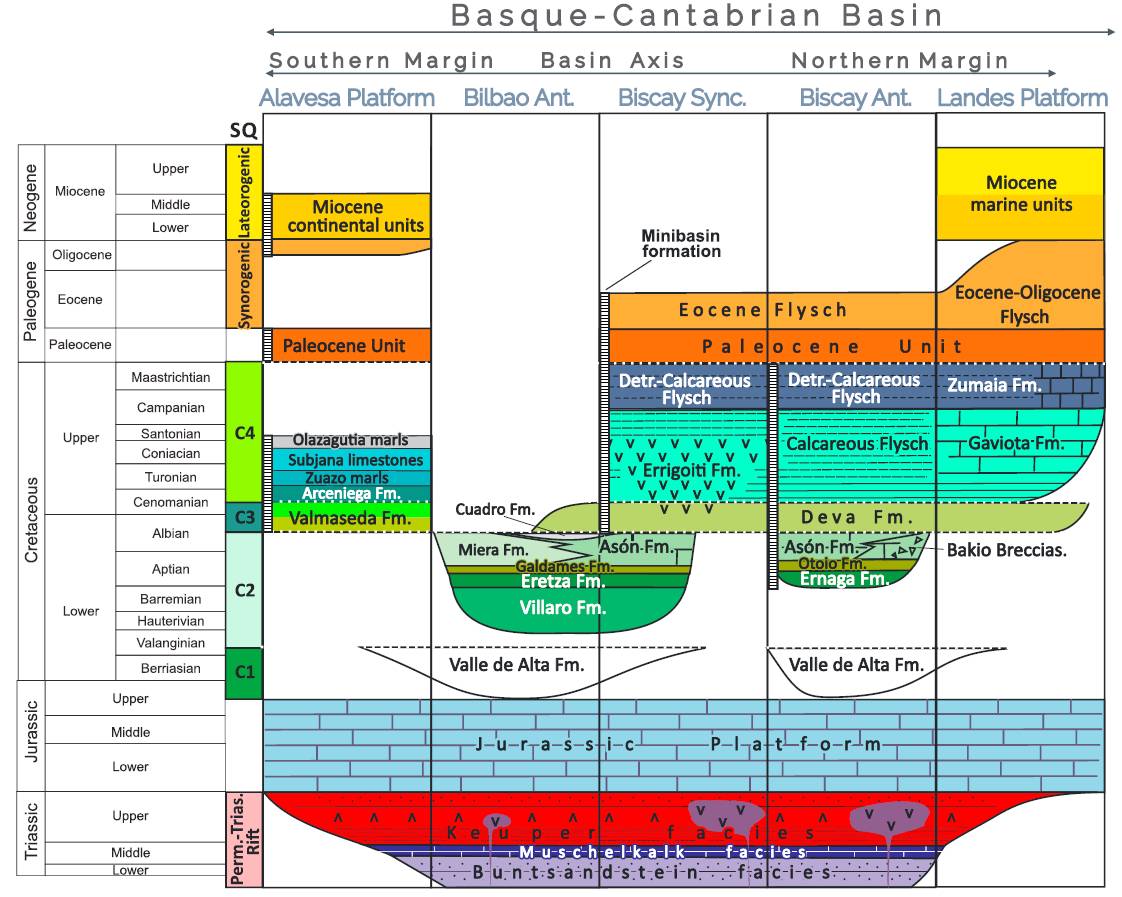
| Evaporite unit/s name | Keuper facies |
| Evaporite unit/s age | Carnian-Rhaetian (Upper Triassic) |
| Evaporite unit/s origin | Marine |
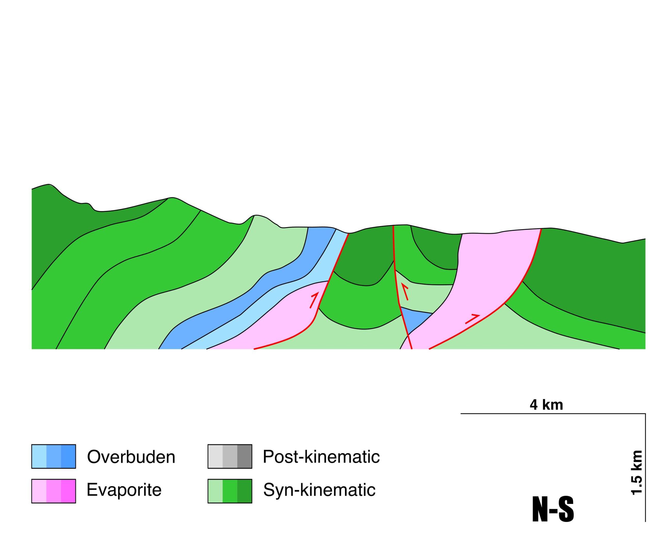
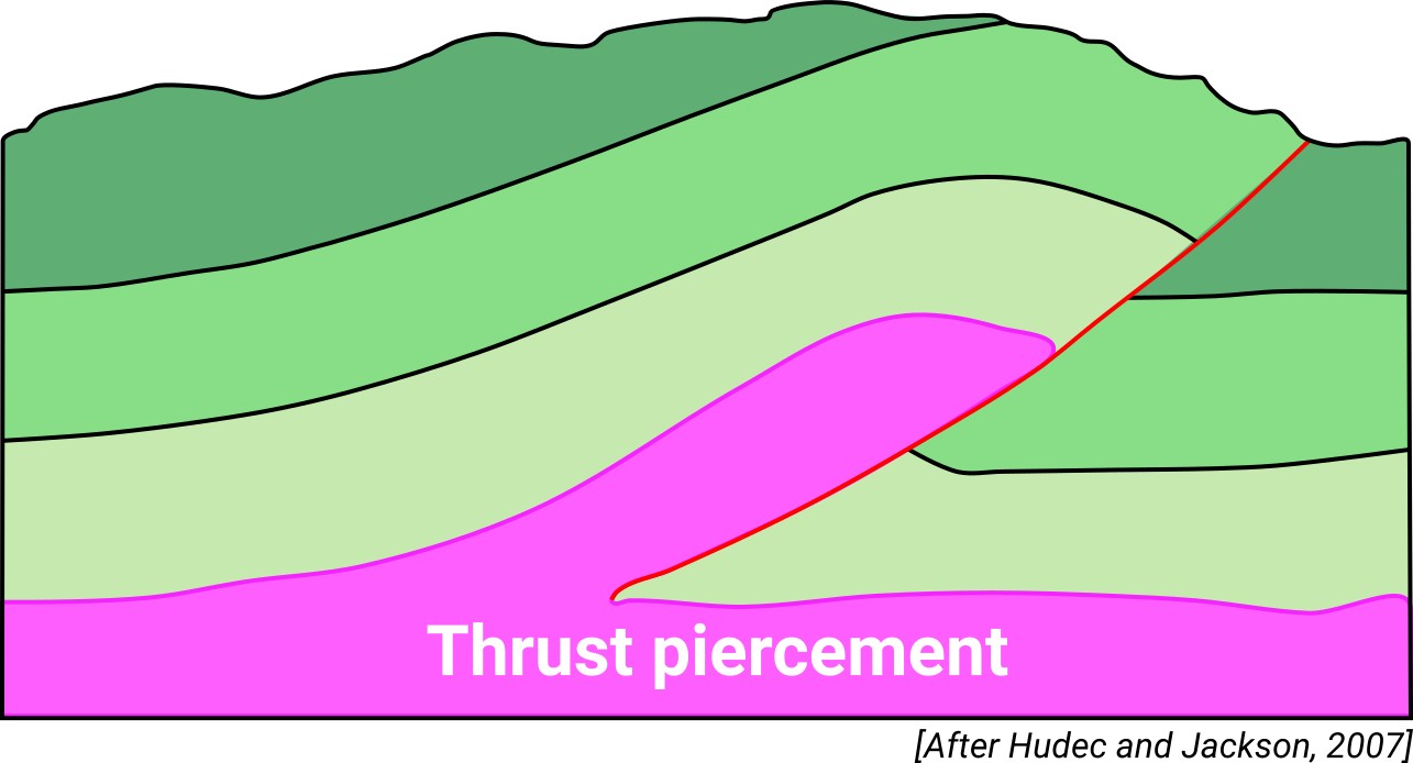
| Classif. (Hudec and Jackson, 2009) | Thrust piercement |
| Classif. (Jackson and Talbot, 1986) | Salt roller |
| Age of evaporite flow or deformation (when deformed) | Upper Jurassic to Upper Cretaceous |
| Other comments | Salt motion lasted until syn-orogenic times, as the Maastrichtian layers are also affected by diapirs (see Ducoux et al., 2020). Complex tectonic structure. |
Generic Data
| Unique ID | 41 |
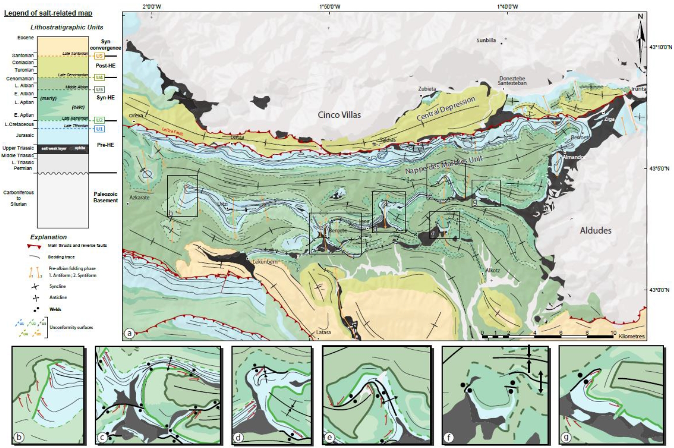
| Name | Beruete |
| Structure type | Evaporite body |
| Deformed/Undeformed | Deformed |
| Buried/Outcropping | Outcropping |
| Geological setting | Basque-Cantabrian Basin |
| Geological Regional Setting | Basque Arc |
| Evaporite unit/s name | Keuper facies |
| Evaporite unit/s age | Carnian-Rhaetian (Upper Triassic) |
| Evaporite unit/s era | Mesozoic |
| Evaporite unit/s origin | Marine |
| Evaporite unit/s composition | Gypsum-Marlstone-Claystone-Ophites |
| Post-kinematic unit/s (or post-evaporite units when evaporites are undeformed) | Quaternary (alluvial and colluvial detrital deposits) |
| Post-kinematic unit/s age (or post-evaporite units when evaporites are undeformed) | Pleistocene-Holocene |
| Classification (Hudec and Jackson, 2009) | Thrust piercement |
| Classification (Jackson and Talbot, 1986) | Salt roller |
| Mining activity? | N |
| Mining activity start | |
| Mining activity end | |
| Mining galleries? | |
| Mining products | |
| Mining sub-products | |
| Evaporite flow? | Y |
| Age of evaporite flow | Late Jurassic – Maastrichtian |
| Flow or deformation triggering mechanisms | Mesozoic extensional regime in the Basque–Cantabrian Basin (Lowe Cretaceous, listric faults and salt tectonics) followed by Iberian plate drifting and tectonic inversion (Upper Cretaceous) |
| Flow-linked structures? | Y |
| Halokinetic structures | Normal high-angle faults / thrust faults / joints / thickness variations / progressive unconformities |
| Post-evaporite and pre-kinematic unit/s (overbuden) | Jurassic (limestones, dolostones, oolitic limestones, marls) |
| Syn-kinematic unit/s | Valanginian – Barremian (Weald facies, limestones, clays and sandstones) / Aptian – Albian (limestones, marls, sandstones and lutites) / Cenomanian – Maastrichtian (shales, marls and limestones) |
| Available seismic profiles | 38 / 33-QU / 34 / 33-QU-1 / OS-9 / 23 / 36 / 33 / 0S12 |
| Available boreholes | |
| Additional comments | Salt motion lasted until syn-orogenic times, as the Maastrichtian layers are also affected by diapirs (see Ducoux et al., 2020). Complex tectonic structure. |
Mining Data
| UNIQUE_ID | 41 |
| Minning exploitations within <2km? | N |
| Historical/Active | |
| Exploitation name #1 | |
| Exploitation ID (Spanish National Mining Cadastre) #1 | |
| Municipality #1 | |
| Province #1 | |
| Company #1 | |
| Main minning Products #1 | |
| Exploitation name #2 | |
| Exploitation ID (Spanish National Mining Cadastre) #2 | |
| Municipality #2 | |
| Province #2 | |
| Company #2 | |
| Main minning Products #2 | |
| Exploitation name #3 | |
| Exploitation ID (Spanish National Mining Cadastre) #3 | |
| Municipality #3 | |
| Province #3 | |
| Company #3 | |
| Main minning Products #3 |
Quantitative Data
| UNIQUE_ID | 41 |
| Outcropping area (km2) | 0.79394 |
| Horizontal intersection area (km2) (when buried) | Not buried |
| Depth of intersection area (km2) (when buried) | Not buried |
| Max. Width (Km) | 4.06492135 |
| Max. Length (Km) | 3.46224935 |
| Max. Evaporites thickness (km) | 1.1 |
| Max. Deformation age (Ma) | 150 |
| Min. Deformation age (Ma) | 66 |
| Deformation stages | 1 |
Reference Data
| UNIQUE_ID | 41 |
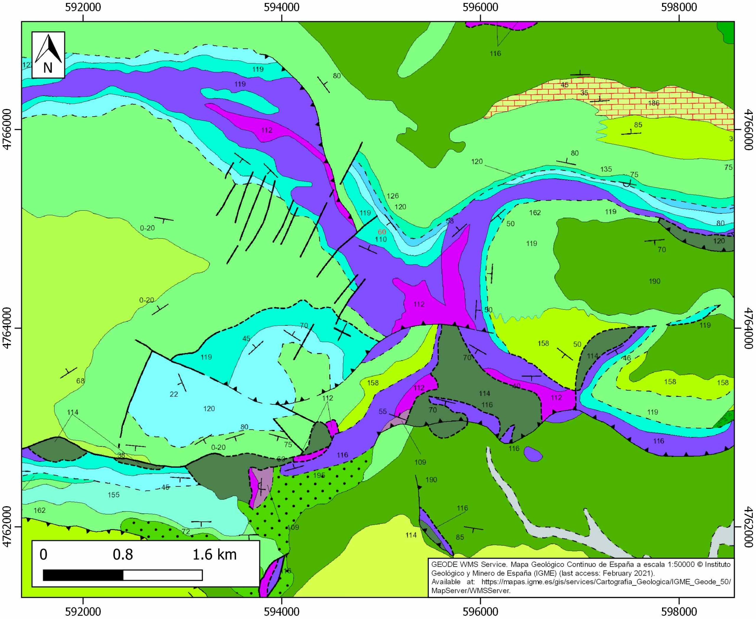
| Section source | IGME MAGNA 50. SHEET 90 (SUMBILLA) |
| Well / Borehole availability #1 | n.a. |
| Well / Borehole availability #2 | n.a. |
| Available data (Stratigraphy) #1 | Torres, L.M., Ramón-Lluch, R., Alarcón, L., 1989. El diapiro prealbiense de Otzola y la estructura de Beruete (manto de los marmoles, Pirineo Vasco). Unublished, 12pp. [link] |
| Available data (Stratigraphy) #2 | Bodego, A., Iriarte, E., Agirrezabala, L. M., García-Mondéjar, J., López-Horgue, M. A., 2015. Synextensional mid-Cretaceous stratigraphic architecture of the eastern Basque–Cantabrian basin margin (western Pyrenees). Cretaceous Research, 55, 229-261. [link] |
| Available data (Stratigraphy) #3 | DeFelipe, I., Pedreira, D., Pulgar, J. A., Van der Beek, P. A., Bernet, M., Pik, R., 2019. Unraveling the Mesozoic and Cenozoic tectonothermal evolution of the eastern Basque‐Cantabrian zone–western Pyrenees by low‐temperature thermochronology. Tectonics, 38(9), 3436-3461. [link] |
| Available data (Stratigraphy) #4 | Ducoux, M., Jolivet, L., Callot, J. P., Aubourg, C., Masini, E., Lahfid, A., Hommonay, E., Cagnard, F., Gumiaux, C., Baudin, T., 2019. The Nappe des Marbres unit of the Basque‐Cantabrian Basin: the tectono‐thermal evolution of a fossil hyperextended rift basin. Tectonics, 38(11), 3881-3915. [link] |
| Available data (Stratigraphy) #5 | Pedrera, A., García‐Senz, J., Ayala, C., Ruiz‐Constán, A., Rodríguez‐Fernández, L. R., Robador, A., González Menéndez, L., 2017. Reconstruction of the exhumed mantle across the North Iberian Margin by crustal‐scale 3‐D gravity inversion and geological cross section. Tectonics, 36, 3155-3177. [link] |
| Available data (Stratigraphy) #6 | Cámara, P., 2017. Salt and Strike-Slip Tectonics as Main Drivers in the Structural Evolution of the Basque-Cantabrian Basin, Spain. In Permo-Triassic Salt Provinces of Europe, North Africa and the Atlantic Margins (pp. 371-393). Elsevier. [link] |
| Regional Stratigraphy | Pedrera, A., García‐Senz, J., Ayala, C., Ruiz‐Constán, A., Rodríguez‐Fernández, L. R., Robador, A., González Menéndez, L., 2017. Reconstruction of the exhumed mantle across the North Iberian Margin by crustal‐scale 3‐D gravity inversion and geological cross section. Tectonics, 36, 3155-3177. [link] |
| Seismic data availability #1 | DeFelipe, I., Álvarez Pulgar, F. J., Pedreira Rodríguez, D., 2018. Crustal structure of the Eastern Basque-Cantabrian Zone-western Pyrenees: from the Cretaceous hyperextension to the Cenozoic inversion. Revista de la Sociedad Geológica de España, 31(2), 69-82. [link] |
| Seismic data availability #2 | Gallart, J., Banda, E., Daignières, M., 1981. Crustal structure of the Paleozoic Axial Zone of the Pyrenees and transition to the North Pyrenean Zone. Annales de Geophysique, 37 (3), 457-480. [link] |
| Seismic data availability #3 | Pedreira, D., Pulgar, J. A., Gallart, J., Díaz, J., 2003. Seismic evidence of Alpine crustal thickening and wedging from the western Pyrenees to the Cantabrian Mountains (north Iberia). Journal of Geophysical Research: Solid Earth, 108(B4), 2204. [link] |
| Available data (Structure) #1 | DeFelipe, I., Pedreira, D., Pulgar, J. A., Van der Beek, P. A., Bernet, M., Pik, R., 2019. Unraveling the Mesozoic and Cenozoic tectonothermal evolution of the eastern Basque‐Cantabrian zone–western Pyrenees by low‐temperature thermochronology. Tectonics, 38(9), 3436-3461. [link] |
| Available data (Structure) #2 | Ducoux, M., Jolivet, L., Callot, J. P., Aubourg, C., Masini, E., Lahfid, A., Hommonay, E., Cagnard, F., Gumiaux, C., Baudin, T., 2019. The Nappe des Marbres unit of the Basque‐Cantabrian Basin: the tectono‐thermal evolution of a fossil hyperextended rift basin. Tectonics, 38(11), 3881-3915. [link] |
| Available data (Structure) #3 | Pedreira, D., 2004. Estructura cortical de la zona de transición entre los Pirineos y la Cordillera Cantábrica [Ph.D. thesis]: Universidad de Oviedo, 364p. [link] |
| Available data (Structure) #4 | Torres, L.M., Ramón-Lluch, R., Alarcón, L., 1989. El diapiro prealbiense de Otzola y la estructura de Beruete (manto de los marmoles, Pirineo Vasco). Unublished, 12pp. [link] |
| Available data (Structure) #5 | DeFelipe, I., Álvarez Pulgar, F. J., Pedreira Rodríguez, D., 2018. Crustal structure of the Eastern Basque-Cantabrian Zone-western Pyrenees: from the Cretaceous hyperextension to the Cenozoic inversion. Revista de la Sociedad Geológica de España, 31(2), 69-82. [link] |
| Available data (Structure) #6 | Bodego, A., Iriarte, E., Agirrezabala, L. M., García-Mondéjar, J., López-Horgue, M. A., 2015. Synextensional mid-Cretaceous stratigraphic architecture of the eastern Basque–Cantabrian basin margin (western Pyrenees). Cretaceous Research, 55, 229-261. [link] |
| Available data (Analogue modelling) #1 | n.a. |
| Available data (Analogue modelling) #2 | n.a. |
| Available data (Analogue modelling) #3 | n.a. |
| Available data (Gravimetry – Tomography) #1 | Pedreira, D., Pulgar, J. A., Gallart, J., Díaz, J., 2003. Seismic evidence of Alpine crustal thickening and wedging from the western Pyrenees to the Cantabrian Mountains (north Iberia). Journal of Geophysical Research: Solid Earth, 108(B4), 2204. [link] |
| Available data (Gravimetry – Tomography) #2 | Pedreira, D., 2004. Estructura cortical de la zona de transición entre los Pirineos y la Cordillera Cantábrica [Ph.D. thesis]: Universidad de Oviedo, 364p. [link] |
| Available data (Gravimetry – Tomography) #3 | n.a. |
| Available data (Geochemistry) #1 | DeFelipe, I., Pedreira, D., Pulgar, J. A., Van der Beek, P. A., Bernet, M., Pik, R., 2019. Unraveling the Mesozoic and Cenozoic tectonothermal evolution of the eastern Basque‐Cantabrian zone–western Pyrenees by low‐temperature thermochronology. Tectonics, 38(9), 3436-3461. [link] |
| Available data (Geochemistry) #2 | Ortí, F., García-Veigas, J., Rossell, L., Jurado, M. J., Utrilla, R., 1996. Formaciones salinas de las cuencas triásicas en la Península Ibérica: Caracterización Petrológica y Geoquímica. Cuadernos de Geología Ibérica, 20, 13-35. [link] |
| Available data (Geochemistry) #3 | Ducoux, M., Jolivet, L., Callot, J. P., Aubourg, C., Masini, E., Lahfid, A., Hommonay, E., Cagnard, F., Gumiaux, C., Baudin, T., 2019. The Nappe des Marbres unit of the Basque‐Cantabrian Basin: the tectono‐thermal evolution of a fossil hyperextended rift basin. Tectonics, 38(11), 3881-3915. [link] |
| Available data (Geochemistry) #4 | n.a. |
| Available data (Petrophysics) #1 | Llamas, B., Castañeda, M. C., Laín, C., Pous, J., 2017. Study of the Basque–Cantabrian basin as a suitable region for the implementation of an energy storage system based on compressed air energy storage (CAES). Environmental Earth Sciences, 76(5), 204. [link] |
| Available data (Petrophysics) #2 | Soto, R., Beamud, E., Roca, E., Carola, E., Almar, Y., 2017. Distinguishing the effect of diapir growth on magnetic fabrics of syn-diapiric overburden rocks: Basque-Cantabrian basin, Northern Spain. Terra Nova 29, 191-201. [link] |
| IGME Geological Map (MAGNA50) Sheet number | 90-Sumbilla. [link] |
| Other Maps #1 (source) | DeFelipe, I., Álvarez Pulgar, F. J., & Pedreira Rodríguez, D., 2018. Crustal structure of the Eastern Basque-Cantabrian Zone-western Pyrenees: from the Cretaceous hyperextension to the Cenozoic inversion. Revista de la Sociedad Geológica de España, 31 (2), 69-82. [link] |
| Other Maps #2 (source) | Ducoux, M., Jolivet, L., Callot, J. P., Aubourg, C., Masini, E., Lahfid, A., Hommonay, E., Cagnard, F., Gumiaux, C., Baudin, T., 2019. The Nappe des Marbres unit of the Basque‐Cantabrian Basin: the tectono‐thermal evolution of a fossil hyperextended rift basin. Tectonics, 38(11), 3881-3915. [link] |
| Other related references #1 | DeFelipe, I., Pedreira, D., Pulgar, J. A., Iriarte, E., Mendia, M., 2017. Mantle exhumation and metamorphism in the B asque‐C antabrian B asin (NS pain): Stable and clumped isotope analysis in carbonates and comparison with ophicalcites in the N orth‐P yrenean Z one (U rdach and L herz). Geochemistry, Geophysics, Geosystems, 18(2), 631-652. [link] |
| Other related references #2 | Pesquera, A., Velasco, F., 1997. Mineralogy, geochemistry and geological significance of tourmaline-rich rocks from the Paleozoic Cinco Villas massif (western Pyrenees, Spain). Contributions to Mineralogy and Petrology, 129(1), 53-74. [link] |
| Other related references #3 | n.a. |
| Other related references #4 | n.a. |
Well and Seismic Data
| UNIQUE_ID | 41 |
| Seismic survey name #1 | 9C4-ST-179 |
| Across structure? #1 | N (within 3km) |
| Seismic profile ID (IGME) #1 | 9983 |
| Seismic profile code #1 | 14556 |
| Seismic profile name #1 | 38 |
| Seismic survey year #1 | 1960 |
| Data repository #1 | SIGEOF Data Catalogue (Private access section). ©Instituto Geológico y Minero de España (IGME). https://info.igme.es/SIGEOF/ |
| Length (km) #1 | 5.08 |
| Seismic survey name #2 | 9C4-ST-179 |
| Across structure? #2 | N (within 3km) |
| Seismic profile ID (IGME) #2 | 9988 |
| Seismic profile code #2 | 14561 |
| Seismic profile name #2 | 33-QU |
| Seismic survey year #2 | 1962 |
| Data repository #2 | SIGEOF Data Catalogue (Private access section). ©Instituto Geológico y Minero de España (IGME). https://info.igme.es/SIGEOF/ |
| Length (km) #2 | 2.90 |
| Seismic survey name #3 | 9C4-ST-179 |
| Across structure? #3 | N (within 3km) |
| Seismic profile ID (IGME) #3 | 9986 |
| Seismic profile code #3 | 14559 |
| Seismic profile name #3 | 34 |
| Seismic survey year #3 | 1962 |
| Data repository #3 | SIGEOF Data Catalogue (Private access section). ©Instituto Geológico y Minero de España (IGME). https://info.igme.es/SIGEOF/ |
| Length (km) #3 | 3.52 |
| Seismic survey name #4 | 9C4-ST-179 |
| Across structure? #4 | N (within 3km) |
| Seismic profile ID (IGME) #4 | 9987 |
| Seismic profile code #4 | 14560 |
| Seismic profile name #4 | 33-QU-1 |
| Seismic survey year #4 | 1962 |
| Data repository #4 | SIGEOF Data Catalogue (Private access section). ©Instituto Geológico y Minero de España (IGME). https://info.igme.es/SIGEOF/ |
| Length (km) #4 | 1.03 |
| Seismic survey name #5 | 9C4OS |
| Across structure? #5 | N (within 3km) |
| Seismic profile ID (IGME) #5 | 10038 |
| Seismic profile code #5 | 14611 |
| Seismic profile name #5 | OS-9 |
| Seismic survey year #5 | 1968 |
| Data repository #5 | SIGEOF Data Catalogue (Private access section). ©Instituto Geológico y Minero de España (IGME). https://info.igme.es/SIGEOF/ |
| Length (km) #5 | 14.62 |
| Seismic survey name #6 | 9C4-ST-179 |
| Across structure? #6 | N (within 3km) |
| Seismic profile ID (IGME) #6 | 9992 |
| Seismic profile code #6 | 14565 |
| Seismic profile name #6 | 23 |
| Seismic survey year #6 | 1962 |
| Data repository #6 | SIGEOF Data Catalogue (Private access section). ©Instituto Geológico y Minero de España (IGME). https://info.igme.es/SIGEOF/ |
| Length (km) #6 | 8.63 |
| Seismic survey name #7 | 9C4-ST-179 |
| Across structure? #7 | N (within 3km) |
| Seismic profile ID (IGME) #7 | 9985 |
| Seismic profile code #7 | 14558 |
| Seismic profile name #7 | 36 |
| Seismic survey year #7 | 1962 |
| Data repository #7 | SIGEOF Data Catalogue (Private access section). ©Instituto Geológico y Minero de España (IGME). https://info.igme.es/SIGEOF/ |
| Length (km) #7 | 2.07 |
| Seismic survey name #8 | 9C4-ST-179 |
| Across structure? #8 | N (within 3km) |
| Seismic profile ID (IGME) #8 | 9989 |
| Seismic profile code #8 | 14562 |
| Seismic profile name #8 | 33 |
| Seismic survey year #8 | 1962 |
| Data repository #8 | SIGEOF Data Catalogue (Private access section). ©Instituto Geológico y Minero de España (IGME). https://info.igme.es/SIGEOF/ |
| Length (km) #8 | 4.36 |
| Seismic survey name #9 | 9C4OS |
| Across structure? #9 | N (within 3km) |
| Seismic profile ID (IGME) #9 | 10047 |
| Seismic profile code #9 | 14620 |
| Seismic profile name #9 | 0S12 |
| Seismic survey year #9 | 1968 |
| Data repository #9 | SIGEOF Data Catalogue (Private access section). ©Instituto Geológico y Minero de España (IGME). https://info.igme.es/SIGEOF/ |
| Length (km) #9 | 9.44 |
| Seismic survey name #10 | |
| Across structure? #10 | |
| Seismic profile ID (IGME) #10 | |
| Seismic profile code #10 | |
| Seismic profile name #10 | |
| Seismic survey year #10 | |
| Data repository #10 | |
| Length (km) #10 | |
| Seismic survey name #11 | |
| Across structure? #11 | |
| Seismic profile ID (IGME) #11 | |
| Seismic profile code #11 | |
| Seismic profile name #11 | |
| Seismic survey year #11 | |
| Data repository #11 | |
| Length (km) #11 | |
| Seismic survey name #12 | |
| Across structure? #12 | |
| Seismic profile ID (IGME) #12 | |
| Seismic profile code #12 | |
| Seismic profile name #12 | |
| Seismic survey year #12 | |
| Data repository #12 | |
| Length (km) #12 | |
| Seismic survey name #13 | |
| Across structure? #13 | |
| Seismic profile ID (IGME) #13 | |
| Seismic profile code #13 | |
| Seismic profile name #13 | |
| Seismic survey year #13 | |
| Data repository #13 | |
| Length (km) #13 | |
| Seismic survey name #14 | |
| Across structure? #14 | |
| Seismic profile ID (IGME) #14 | |
| Seismic profile code #14 | |
| Seismic profile name #14 | |
| Seismic survey year #14 | |
| Data repository #14 | |
| Length (km) #14 | |
| Seismic survey name #15 | |
| Across structure? #15 | |
| Seismic profile ID (IGME) #15 | |
| Seismic profile code #15 | |
| Seismic profile name #15 | |
| Seismic survey year #15 | |
| Data repository #15 | |
| Length (km) #15 | |
| Seismic survey name #16 | |
| Across structure? #16 | |
| Seismic profile ID (IGME) #16 | |
| Seismic profile code #16 | |
| Seismic profile name #16 | |
| Seismic survey year #16 | |
| Data repository #16 | |
| Length (km) #16 | |
| Seismic survey name #17 | |
| Across structure? #17 | |
| Seismic profile ID (IGME) #17 | |
| Seismic profile code #17 | |
| Seismic profile name #17 | |
| Seismic survey year #17 | |
| Data repository #17 | |
| Length (km) #17 | |
| Seismic survey name #18 | |
| Across structure? #18 | |
| Seismic profile ID (IGME) #18 | |
| Seismic profile code #18 | |
| Seismic profile name #18 | |
| Seismic survey year #18 | |
| Data repository #18 | |
| Length (km) #18 | |
| Seismic survey name #19 | |
| Across structure? #19 | |
| Seismic profile ID (IGME) #19 | |
| Seismic profile code #19 | |
| Seismic profile name #19 | |
| Seismic survey year #19 | |
| Data repository #19 | |
| Length (km) #19 | |
| Seismic survey name #20 | |
| Across structure? #20 | |
| Seismic profile ID (IGME) #20 | |
| Seismic profile code #20 | |
| Seismic profile name #20 | |
| Seismic survey year #20 | |
| Data repository #20 | |
| Length (km) #20 | |
| Seismic survey name #21 | |
| Across structure? #21 | |
| Seismic profile ID (IGME) #21 | |
| Seismic profile code #21 | |
| Seismic profile name #21 | |
| Seismic survey year #21 | |
| Data repository #21 | |
| Length (km) #21 | |
| Borehole name #1 | |
| Company #1 | |
| Traget #1 | |
| Across structure? #1 | |
| Borehole name #2 | |
| Company #2 | |
| Traget #2 | |
| Across structure? #2 | |
| Borehole name #3 | |
| Company #3 | |
| Traget #3 | |
| Across structure? #3 | |
| Borehole name #4 | |
| Company #4 | |
| Traget #4 | |
| Across structure? #4 | |
| Borehole name #5 | |
| Company #5 | |
| Traget #5 | |
| Across structure? #5 | |
| Borehole name #6 | |
| Company #6 | |
| Traget #6 | |
| Across structure? #6 | |
| Borehole name #7 | |
| Company #7 | |
| Traget #7 | |
| Across structure? #7 | |
| Borehole name #8 | |
| Company #8 | |
| Traget #8 | |
| Across structure? #8 | |
| Borehole name #9 | |
| Company #9 | |
| Traget #9 | |
| Across structure? #9 | |
| Borehole name #10 | |
| Company #10 | |
| Traget #10 | |
| Across structure? #10 | |
| Borehole name #11 | |
| Company #11 | |
| Traget #11 | |
| Across structure? #11 | |
| Borehole name #12 | |
| Company #12 | |
| Traget #12 | |
| Across structure? #12 | |
| Borehole name #13 | |
| Company #13 | |
| Traget #13 | |
| Across structure? #13 | |
| Borehole name #14 | |
| Company #14 | |
| Traget #14 | |
| Across structure? #14 | |
| Borehole name #15 | |
| Company #15 | |
| Traget #15 | |
| Across structure? #15 |
Geographical Data (EPSG:4326 - WGS 84)
| UNIQUE_ID | 41 |
| X Centroid (Structure shape) | -1.830629 |
| Y Centroid (Structure shape) | -1.830629 |
| Xmin (Structure shape) | -1.855310 |
| Xmax (Structure shape) | -1.810059 |
| Ymin (Structure shape) | 43.006623 |
| Ymax (Structure shape) | 43.043245 |
| Xmin seismic line #1 | -1.795883 |
| Xmax seismic line #1 | -1.789154 |
| Ymin seismic line #1 | 42.962977 |
| Ymax seismic line #1 | 43.008064 |
| Xmin seismic line #2 | -1.788550 |
| Xmax seismic line #2 | -1.779306 |
| Ymin seismic line #2 | 43.002692 |
| Ymax seismic line #2 | 43.027525 |
| Xmin seismic line #3 | -1.807368 |
| Xmax seismic line #3 | -1.769593 |
| Ymin seismic line #3 | 42.998774 |
| Ymax seismic line #3 | 43.008157 |
| Xmin seismic line #4 | -1.799146 |
| Xmax seismic line #4 | -1.787149 |
| Ymin seismic line #4 | 43.018093 |
| Ymax seismic line #4 | 43.020912 |
| Xmin seismic line #5 | -1.837728 |
| Xmax seismic line #5 | -1.795056 |
| Ymin seismic line #5 | 42.891037 |
| Ymax seismic line #5 | 43.006641 |
| Xmin seismic line #6 | -1.812689 |
| Xmax seismic line #6 | -1.746836 |
| Ymin seismic line #6 | 42.941468 |
| Ymax seismic line #6 | 42.996389 |
| Xmin seismic line #7 | -1.824055 |
| Xmax seismic line #7 | -1.803017 |
| Ymin seismic line #7 | 43.004879 |
| Ymax seismic line #7 | 43.014102 |
| Xmin seismic line #8 | -1.828227 |
| Xmax seismic line #8 | -1.821013 |
| Ymin seismic line #8 | 42.973803 |
| Ymax seismic line #8 | 43.011459 |
| Xmin seismic line #9 | -1.790661 |
| Xmax seismic line #9 | -1.680176 |
| Ymin seismic line #9 | 42.992972 |
| Ymax seismic line #9 | 43.008621 |
| Xmin seismic line #10 | |
| Xmax seismic line #10 | |
| Ymin seismic line #10 | |
| Ymax seismic line #10 | |
| Xmin seismic line #11 | |
| Xmax seismic line #11 | |
| Ymin seismic line #11 | |
| Ymax seismic line #11 | |
| Xmin seismic line #12 | |
| Xmax seismic line #12 | |
| Ymin seismic line #12 | |
| Ymax seismic line #12 | |
| Xmin seismic line #13 | |
| Xmax seismic line #13 | |
| Ymin seismic line #13 | |
| Ymax seismic line #13 | |
| Xmin seismic line #14 | |
| Xmax seismic line #14 | |
| Ymin seismic line #14 | |
| Ymax seismic line #14 | |
| Xmin seismic line #15 | |
| Xmax seismic line #15 | |
| Ymin seismic line #15 | |
| Ymax seismic line #15 | |
| Xmin seismic line #16 | |
| Xmax seismic line #16 | |
| Ymin seismic line #16 | |
| Ymax seismic line #16 | |
| Xmin seismic line #17 | |
| Xmax seismic line #17 | |
| Ymin seismic line #17 | |
| Ymax seismic line #17 | |
| Xmin seismic line #18 | |
| Xmax seismic line #18 | |
| Ymin seismic line #18 | |
| Ymax seismic line #18 | |
| Xmin seismic line #19 | |
| Xmax seismic line #19 | |
| Ymin seismic line #19 | |
| Ymax seismic line #19 | |
| Xmin seismic line #20 | |
| Xmax seismic line #20 | |
| Ymin seismic line #20 | |
| Ymax seismic line #20 | |
| Xmin seismic line #21 | |
| Xmax seismic line #21 | |
| Ymin seismic line #21 | |
| Ymax seismic line #21 | |
| X borehole #1 | |
| Y borehole #1 | |
| X borehole #2 | |
| Y borehole #2 | |
| X borehole #3 | |
| Y borehole #3 | |
| X borehole #4 | |
| Y borehole #4 | |
| X borehole #5 | |
| Y borehole #5 | |
| X borehole #6 | |
| Y borehole #6 | |
| X borehole #7 | |
| Y borehole #7 | |
| X borehole #8 | |
| Y borehole #8 | |
| X borehole #9 | |
| Y borehole #9 | |
| X borehole #10 | |
| Y borehole #10 | |
| X borehole #11 | |
| Y borehole #11 | |
| X borehole #12 | |
| Y borehole #12 | |
| X borehole #13 | |
| Y borehole #13 | |
| X borehole #14 | |
| Y borehole #14 | |
| X borehole #15 | |
| Y borehole #15 |

