General Information
| Structure type | Evaporite body |
| Deformed/Undeformed | Deformed |
| Geological Setting | Eastern-Central Domain, Ebro foreland basin |
| Outcropping/buried | Outcropping |
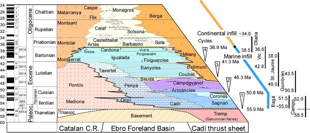
| Evaporite unit/s name | Barbastro Fm., Cardona Fm. |
| Evaporite unit/s age | Priabonian (Eocene), Upper Priabonian-Chattian (Eocene-Oligocene) |
| Evaporite unit/s origin | Continental, Marine |
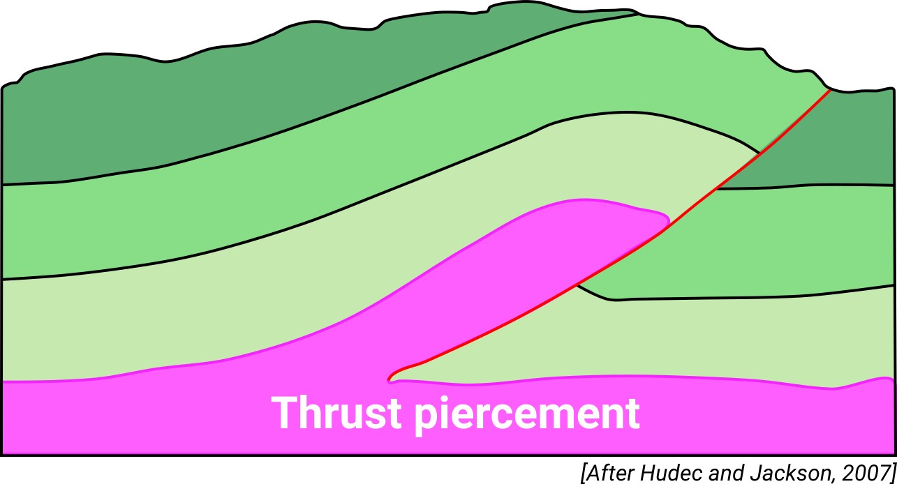
| Classif. (Hudec and Jackson, 2009) | Ductile piercement, Thrust piercement |
| Classif. (Jackson and Talbot, 1986) | Salt anticline |
| Age of evaporite flow or deformation (when deformed) | late Oligocene, Lower Oligocene |
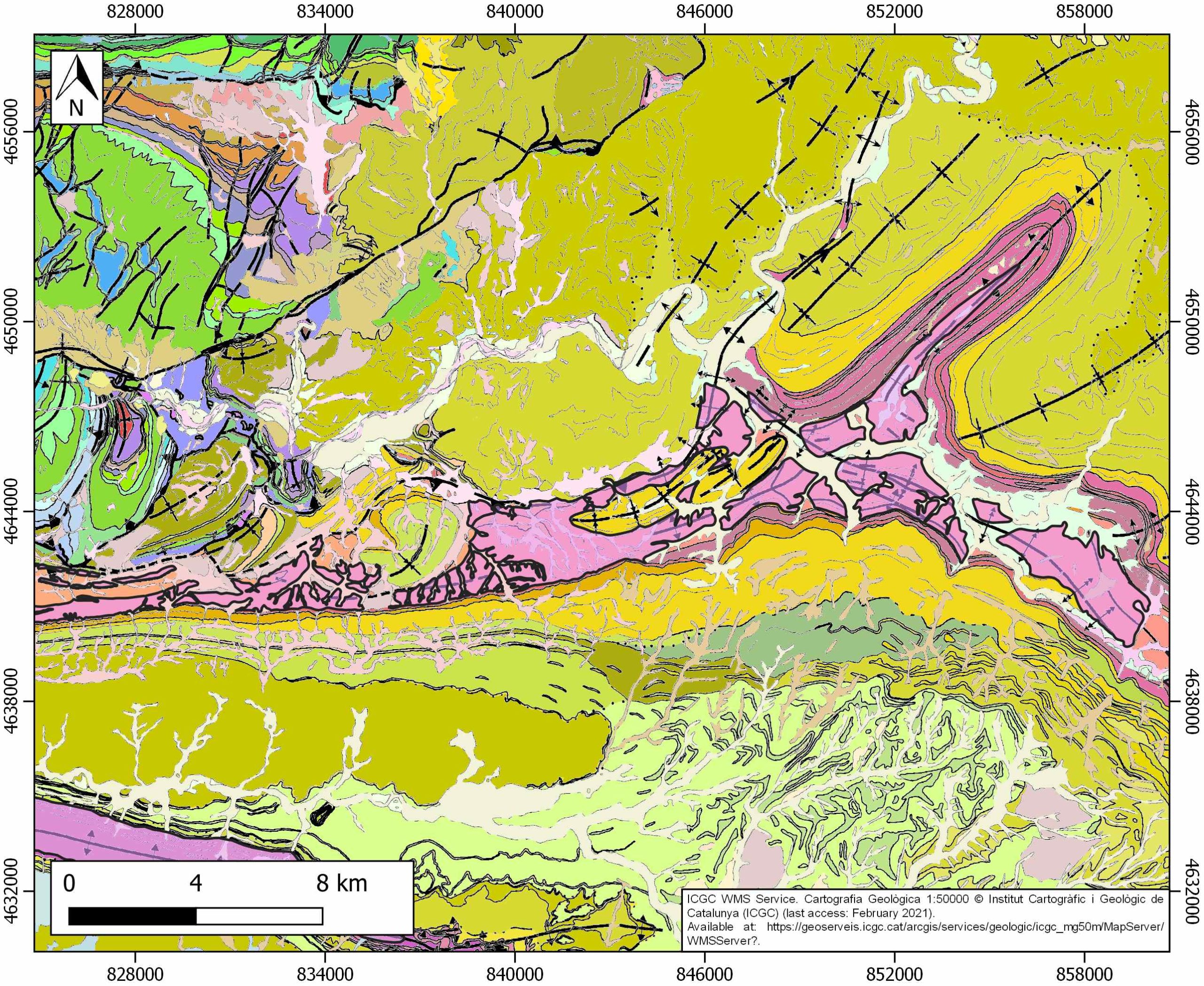
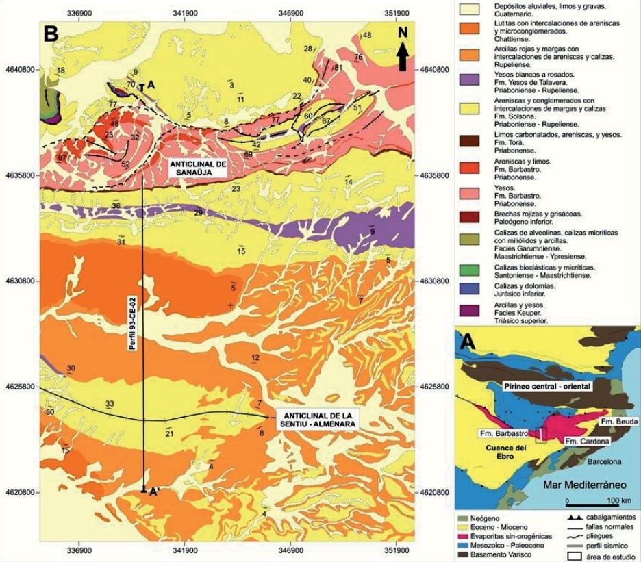
| Other comments | Forming the Sanahuja Anticline and its eastwards and north-westwards propagation. Localized diapirism. |
Generic Data
| Unique ID | 124 |
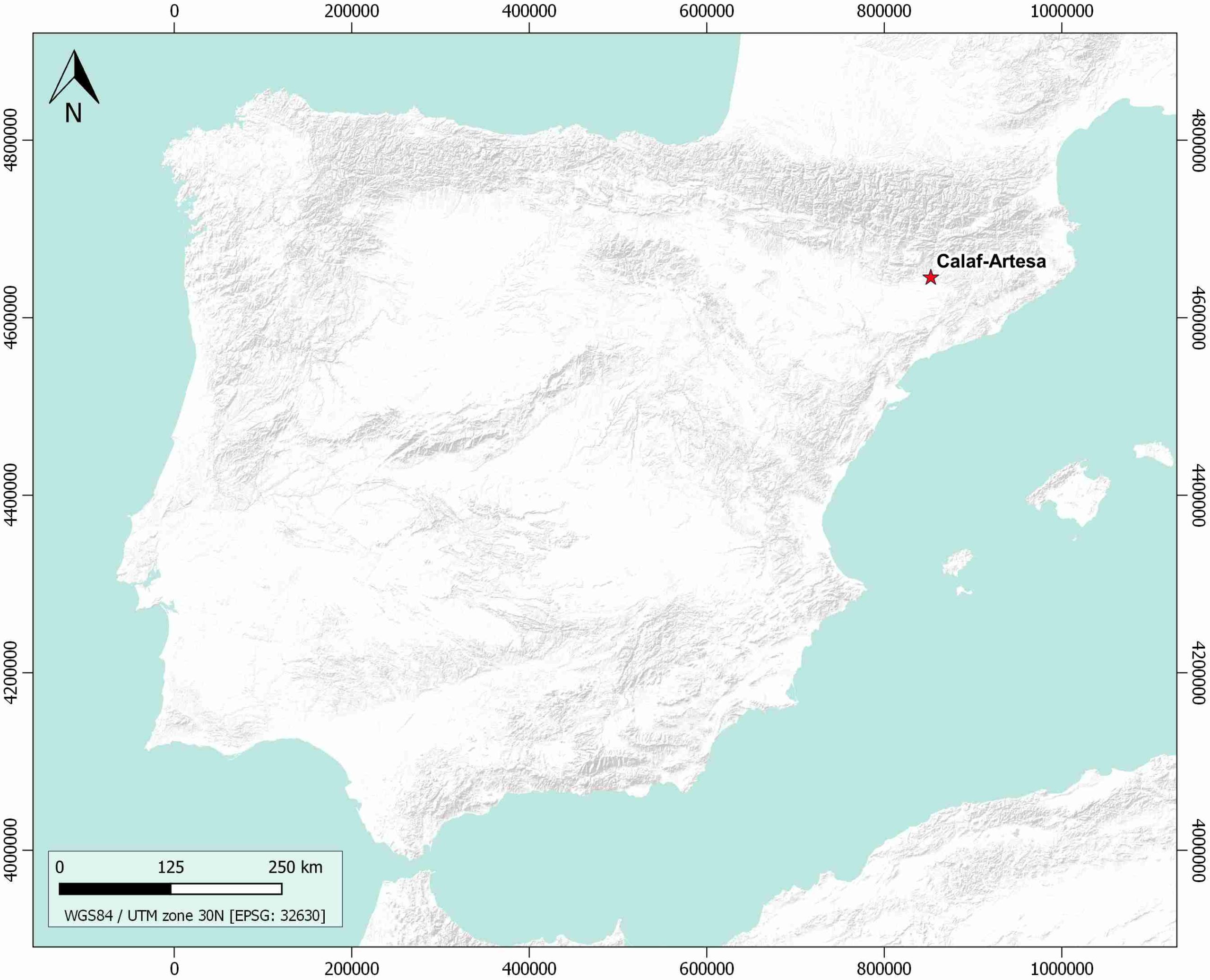
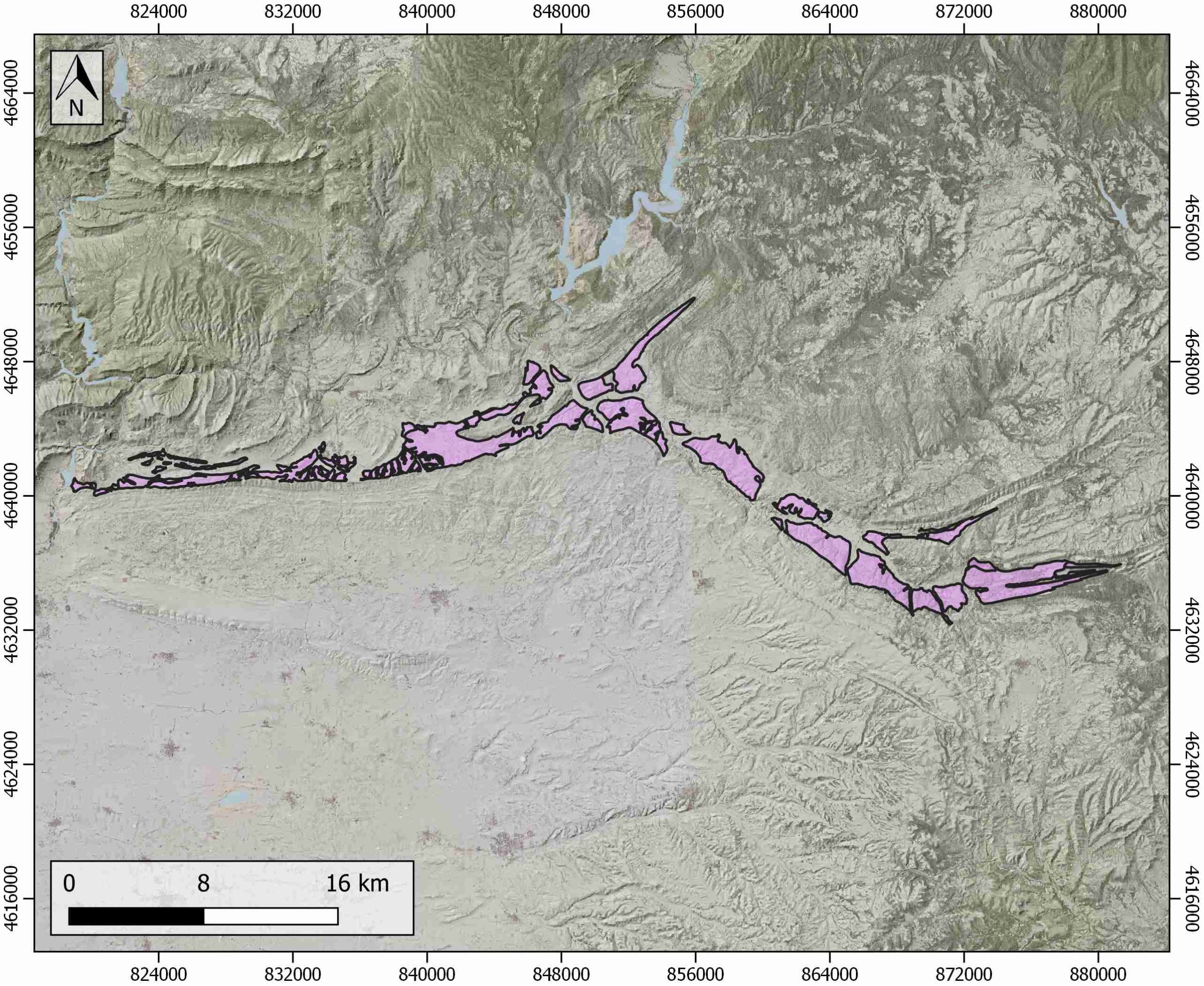
| Name | Calaf-Artesa |
| Structure type | Evaporite body |
| Deformed/Undeformed | Deformed |
| Buried/Outcropping | Outcropping |
| Geological setting | Ebro Basin |
| Geological Regional Setting | Central-Eastern Sector |
| Evaporite unit/s name | Cardona Fm., Barbastro Fm. |
| Evaporite unit/s age | Upper Priabonian-Upper Rupelian (Eocene-Oligocene) |
| Evaporite unit/s era | Cenozoic |
| Evaporite unit/s origin | Continental |
| Evaporite unit/s composition | Gypsum-Marlstone-Shale |
| Post-kinematic unit/s (or post-evaporite units when evaporites are undeformed) | Pliocene (siltstones, sandstones, conglomerates) ; Quaternary (alluvial and colluvial detrital deposits) |
| Post-kinematic unit/s age (or post-evaporite units when evaporites are undeformed) | Pliocene-Holocene |
| Classification (Hudec and Jackson, 2009) | Thrust piercement / Ductile piercement |
| Classification (Jackson and Talbot, 1986) | Salt anticline |
| Mining activity? | Y |
| Mining activity start | |
| Mining activity end | Active |
| Mining galleries? | Y |
| Mining products | Potassium salt |
| Mining sub-products | Potassium salt |
| Evaporite flow? | Y |
| Age of evaporite flow | Oligocene |
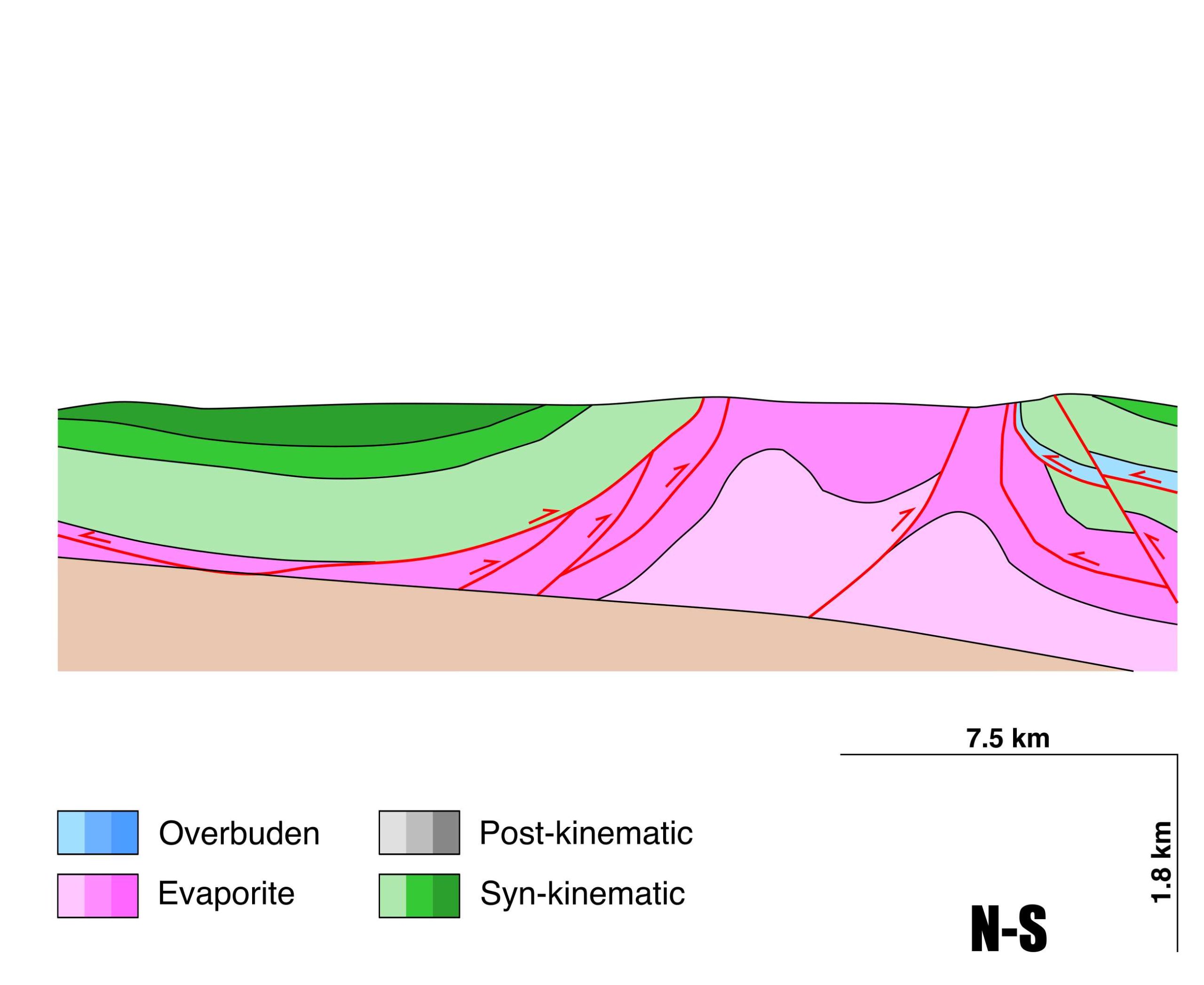
| Flow or deformation triggering mechanisms | Alpine compression and thrusting, and buoyancy and differential loading (localized diapiric ascent in Bellfort and NE Pons areas) |
| Flow-linked structures? | Y |
| Halokinetic structures | Normal faults / anticline-syncline folding / Folded unconformities |
| Post-evaporite and pre-kinematic unit/s (overbuden) | – |
| Syn-kinematic unit/s | Early-Middle Rupelian (limestones and marlstones) ; Middle Rupelian (Torà Fm., marlstones, calcareous limolites, limestones, marly limestones) ; Chattian (marlstones, limestones, sandstones and conglomerates) |
| Available seismic profiles | 33-1 / 8 / 5 / 13 / 51 / 39 / 1 / P-3 / P-2 / 54 / PIR-86-01 / PIR-86-01 / PIR-86-01 / PIR-86-01 / PIR-86-01 / PIR-86-01 / 33-1 / 44199 / 8 / 5 / 49 |
| Available boreholes | CALAF-102 / CALAF-109 / CALAF-101 / CALAF-107 / CALAF-112 / CALAF-104 / MASSOTERES / ARTESA DE SEGRE |
| Additional comments | Forming the Sanahuja Anticline and its eastwards and north-westwards propagation. Localized diapirism. |
Mining Data
| UNIQUE_ID | 124 |
| Minning exploitations within <2km? | Y |
| Historical/Active | Active |
| Exploitation name #1 | SOLEROT |
| Exploitation ID (Spanish National Mining Cadastre) #1 | 5361 |
| Municipality #1 | Biosca |
| Province #1 | LERIDA |
| Company #1 | CANTERAS DE LA SEGARRA, SL |
| Main minning Products #1 | Potassium salt |
| Exploitation name #2 | BIOSCA |
| Exploitation ID (Spanish National Mining Cadastre) #2 | 5568 |
| Municipality #2 | Biosca |
| Province #2 | LERIDA |
| Company #2 | YESOVAL, SA |
| Main minning Products #2 | Gypsum, Potassium salt |
| Exploitation name #3 | SOT COMAS |
| Exploitation ID (Spanish National Mining Cadastre) #3 | 90581 |
| Municipality #3 | Massoteres |
| Province #3 | LERIDA |
| Company #3 | JOAN SISQUELLA ALAVEDRA |
| Main minning Products #3 | Potassium salt |
Quantitative Data
| UNIQUE_ID | 124 |
| Outcropping area (km2) | 83.43407 |
| Horizontal intersection area (km2) (when buried) | Not buried |
| Depth of intersection area (km2) (when buried) | Not buried |
| Max. Width (Km) | 16.9802805 |
| Max. Length (Km) | 62.6143856 |
| Max. Evaporites thickness (km) | 1.8 |
| Max. Deformation age (Ma) | 34 |
| Min. Deformation age (Ma) | 23 |
| Deformation stages | 1 |
Reference Data
| UNIQUE_ID | 124 |
| Section source | Santolaria, P., Pla, O., Soto Marín, R. L., Casas-Sainz, A. M., Gratacós, O., Roca, E., …, Pueyo Morer, E. L., 2016. Variaciones laterales de la estructura del anticlinal de Barbastro-Balaguer. Geotemas, 16, 105-108. [link] |
| Well / Borehole availability #1 | n.a. |
| Well / Borehole availability #2 | n.a. |
| Available data (Stratigraphy) #1 | Saez, A., Anadon, P., Herrero, M. J., Moscariello, A., 2007. Variable style of transition between Palaeogene fluvial fan and lacustrine systems, southern Pyrenean foreland, NE Spain. Sedimentology, 54(2), 367-390. [link] |
| Available data (Stratigraphy) #2 | Lucha, P., Gutiérrez, F., Galve, J. P., Guerrero, J., 2012. Geomorphic and stratigraphic evidence of incision-induced halokinetic uplift and dissolution subsidence in transverse drainages crossing the evaporite-cored Barbastro–Balaguer Anticline (Ebro Basin, NE Spain). Geomorphology, 171, 154-172. [link] |
| Available data (Stratigraphy) #3 | Anadón, P., Cabrera, L., Colldeforns, B., Sáez, A., 1989. Los sistemas lacustres del Eoceno superior y Oligoceno del sector oriental de la Cuenca del Ebro. Acta geológica hispánica, 24(3), 205-230. [link] |
| Available data (Stratigraphy) #4 | Del Santo, G., García-Sansegundo, J., Sarasa, L., Torrebadella, J., 2000. Estratigrafía y estructura del Terciario en el sector oriental de la cuenca del Ebro entre Solsona y Manresa (NE de España). Revista de la Sociedad Geológica de España, 13(2), 265-278. [link] |
| Available data (Stratigraphy) #5 | Costa, E., Garces, M., López‐Blanco, M., Beamud, E., Gómez‐Paccard, M., Larrasoaña, J. C., 2010. Closing and continentalization of the South Pyrenean foreland basin (NE Spain): magnetochronological constraints. Basin Research, 22(6), 904-917. [link] |
| Available data (Stratigraphy) #6 | Senz, J. G., Zamorano, M., 1992. Evolución tectónica y sedimentaria durante el Priaboniense superior-Mioceno inferior, en el frente de cabalgamiento de las Sierras Marginales occidentales. Acta geológica hispánica, 27(1-2), 195-209. [link] |
| Regional Stratigraphy | Vergés, J., Fernàndez, M., Martìnez, A., 2002. The Pyrenean orogen: pre-, syn-, and post-collisional evolution. Journal of the Virtual Explorer, 8, 55-74. [link] |
| Seismic data availability #1 | Pla, O., Ferrer García, J. O., Gratacós Torrà, Ò., Muñoz, J. A., Roca i Abella, E., 2016. Influencia de los niveles evaporíticos sin-orogénicos en la geometría del frente surpirenaico central: Anticlinales de Sanaüja y de La Sentiu-Almenara. Geo-Temas, 2016, vol. 16, num. 1, p. 65-68. [link] |
| Seismic data availability #2 | Sans, M., Vergés, J., 1995. Fold Development Related to Contractional Salt Tectonics: Southeastern Pyrenean Thrust Front, Spain. In M.P.A. Jackson, D.G. Roberts, S. Snelson (eds.), Salt Tectonics: A Global Perspective. [link] |
| Seismic data availability #3 | n.a. |
| Available data (Structure) #1 | Santolaria, P., Pla, O., Soto Marín, R. L., Casas-Sainz, A. M., Gratacós, O., Roca, E., …, Pueyo Morer, E. L., 2016. Variaciones laterales de la estructura del anticlinal de Barbastro-Balaguer. Geotemas, 16, 105-108. [link] |
| Available data (Structure) #2 | Pla, O., Ferrer García, J. O., Gratacós Torrà, Ò., Muñoz, J. A., Roca i Abella, E., 2016. Influencia de los niveles evaporíticos sin-orogénicos en la geometría del frente surpirenaico central: Anticlinales de Sanaüja y de La Sentiu-Almenara. Geo-Temas, 2016, vol. 16, num. 1, p. 65-68. [link] |
| Available data (Structure) #3 | Sans, M., Vergés, J., 1995. Fold Development Related to Contractional Salt Tectonics: Southeastern Pyrenean Thrust Front, Spain. In M.P.A. Jackson, D.G. Roberts, S. Snelson (eds.), Salt Tectonics: A Global Perspective. [link] |
| Available data (Structure) #4 | Sans, M., Muñoz, J. A., & Vergés, J., 1996. Triangle zone and thrust wedge geometries related to evaporitic horizons (southern Pyrenees). Bulletin of Canadian Petroleum Geology, 44(2), 375-384. [link] |
| Available data (Structure) #5 | Muñoz, J. A., Mencos, J., Roca, E., Carrera, N., Gratacós, O., Ferrer, O., Fernández, O., 2018. The structure of the South-Central-Pyrenean fold and thrust belt as constrained by subsurface data. Geologica Acta, 16(4), 439-460. [link] |
| Available data (Structure) #6 | Krzywiec, P., Vergés, J., 2007. Role of the foredeep evaporites in wedge tectonics and formation of triangle zones: comparison of the Carpathian and Pyrenean Thrust Fronts. In Thrust belts and foreland basins (pp. 385-396). Springer, Berlin, Heidelberg. [link] |
| Available data (Analogue modelling) #1 | Sans, M., 2003. From thrust tectonics to diapirism. The role of evaporites in the kinematic evolution of the eastern South Pyrenean front. Geologica Acta, 1(3), 239-260. [link] |
| Available data (Analogue modelling) #2 | n.a. |
| Available data (Analogue modelling) #3 | n.a. |
| Available data (Gravimetry – Tomography) #1 | Santolaria, P., Rubio Sánchez-Aguililla, F. M., Ayala Galán, C., Pueyo Morer, E. L., Rodriguez Pintó, A., Soto Marín, R. L., Casas, A. M., 2016. Gravimetría preliminar del antepaís Pirenaico central: distribución de las evaporitas y geometría de zócalo. Geotemas, 16(2), 559-562. [link] |
| Available data (Gravimetry – Tomography) #2 | Ayala, C., Bohoyo, F., Maestro, A., Reguera, M. I., Torne, M., Rubio, F., Fernández, M., García-Lobón, J. L., 2016. Updated Bouguer anomalies of the Iberian Peninsula: a new perspective to interpret the regional geology. Journal of Maps, 12(5), 1089-1092. [link] |
| Available data (Gravimetry – Tomography) #3 | n.a. |
| Available data (Geochemistry) #1 | Cendón Sevilla, D. I., 1999. Evolución geoquímica de cuencas evaporíticas terciarias: implicaciones en la composición isotópica disuelto en el océano durante el terciario [Ph.D. thesis]: University of Barcelona, 335p. [link] |
| Available data (Geochemistry) #2 | n.a. |
| Available data (Geochemistry) #3 | n.a. |
| Available data (Geochemistry) #4 | n.a. |
| Available data (Petrophysics) #1 | Santolaria, P., Casas-Sainz, A. M., Soto, R., Casas, A., 2017. Gravity modelling to assess salt tectonics in the western end of the South Pyrenean Central Unit. Journal of the Geological Society, 174(2), 269-288. [link] |
| Available data (Petrophysics) #2 | Oliván, C., Pueyo, E. L., Pocoví, A., Luzón, A., Martínez-Peña, M. B., 2008. Fábricas magnéticas (ASM) en el anticlinal de Barbastro–Balaguer (Pirineo Central): implicaciones cinemáticas. Geotemas, 10, 1239-1242. [link] |
| IGME Geological Map (MAGNA50) Sheet number | 328-Artesa de Segre. [link] and 329-Pons. [link] and 361-Guisona. [link] |
| Other Maps #1 (source) | Pla, O., Ferrer García, J. O., Gratacós Torrà, Ò., Muñoz, J. A., Roca i Abella, E., 2016. Influencia de los niveles evaporíticos sin-orogénicos en la geometría del frente surpirenaico central: Anticlinales de Sanaüja y de La Sentiu-Almenara. Geo-Temas, 2016, vol. 16, num. 1, p. 65-68. [link] |
| Other Maps #2 (source) | Del Santo, G., García-Sansegundo, J., Sarasa, L., Torrebadella, J., 2000. Estratigrafía y estructura del Terciario en el sector oriental de la cuenca del Ebro entre Solsona y Manresa (NE de España). Revista de la Sociedad Geológica de España, 13(2), 265-278. [link] |
| Other related references #1 | Pla, O., Muñoz*, J. A., Ferrer, O., Roca, E., Gratacós, Ò., Ramírez, B., 2015. Halokinetic Deformations During the Development of Detachment Folds on Multilayered Syn-Orogenic Evaporitic Sequences: Results From Analogue Modeling and Comparison With the Sanaüja Anticline (Ebro Foreldand Basin, Iberian Peninsula). In International Conference and Exhibition, Melbourne, Australia 13-16 September 2015 (pp. 121-121). Society of Exploration Geophysicists and American Association of Petroleum Geologists. [link] |
| Other related references #2 | Sans, M., Vergés, J., Gomis, E., Parés, J. M., Schiattarella, M., Travé, A., …, Doulcet, A., 2003. Layer parallel shortening in salt-detached folds: constraint on cross-section restoration. Tectonophysics, 372(1-2), 85-104. [link] |
| Other related references #3 | Krzywiec, P., Vergés, J., 2006. Salt Tectonics in Compressional Settings: Comparison of the S Pyrenees and the N Carpathians. Geolines, 20, 81. [link] |
| Other related references #4 | Santolaria, P., Luzón, A., Casas, A. M., Soto, R., 2015. Coupling far and near tectonic signals in syn-orogenic sediments: the Olvena growth strata (Sierras Marginales, southern Pyrenees). Geologica Acta, 13(4), 297-308. [link] |
Well and Seismic Data
| UNIQUE_ID | 124 |
| Seismic survey name #1 | 12D3-33 |
| Across structure? #1 | Y |
| Seismic profile ID (IGME) #1 | 10470 |
| Seismic profile code #1 | 15099 |
| Seismic profile name #1 | 33-1 |
| Seismic survey year #1 | 1961 |
| Data repository #1 | SIGEOF Data Catalogue (Private access section). ©Instituto Geológico y Minero de España (IGME). https://info.igme.es/SIGEOF/ |
| Length (km) #1 | 7.79 |
| Seismic survey name #2 | 12D3-8 |
| Across structure? #2 | Y |
| Seismic profile ID (IGME) #2 | 10487 |
| Seismic profile code #2 | 15116 |
| Seismic profile name #2 | 8 |
| Seismic survey year #2 | 1961 |
| Data repository #2 | SIGEOF Data Catalogue (Private access section). ©Instituto Geológico y Minero de España (IGME). https://info.igme.es/SIGEOF/ |
| Length (km) #2 | 14.42 |
| Seismic survey name #3 | 12D2-5 |
| Across structure? #3 | Y |
| Seismic profile ID (IGME) #3 | 10381 |
| Seismic profile code #3 | 15009 |
| Seismic profile name #3 | 5 |
| Seismic survey year #3 | 1961 |
| Data repository #3 | SIGEOF Data Catalogue (Private access section). ©Instituto Geológico y Minero de España (IGME). https://info.igme.es/SIGEOF/ |
| Length (km) #3 | 18.17 |
| Seismic survey name #4 | 12D3-13 |
| Across structure? #4 | Y |
| Seismic profile ID (IGME) #4 | 10457 |
| Seismic profile code #4 | 15086 |
| Seismic profile name #4 | 13 |
| Seismic survey year #4 | 1961 |
| Data repository #4 | SIGEOF Data Catalogue (Private access section). ©Instituto Geológico y Minero de España (IGME). https://info.igme.es/SIGEOF/ |
| Length (km) #4 | 8.66 |
| Seismic survey name #5 | 12D2-51 |
| Across structure? #5 | Y |
| Seismic profile ID (IGME) #5 | 10385 |
| Seismic profile code #5 | 15013 |
| Seismic profile name #5 | 51 |
| Seismic survey year #5 | 1977 |
| Data repository #5 | SIGEOF Data Catalogue (Private access section). ©Instituto Geológico y Minero de España (IGME). https://info.igme.es/SIGEOF/ |
| Length (km) #5 | 15.59 |
| Seismic survey name #6 | 12D3-39 |
| Across structure? #6 | Y |
| Seismic profile ID (IGME) #6 | 10479 |
| Seismic profile code #6 | 15108 |
| Seismic profile name #6 | 39 |
| Seismic survey year #6 | 1961 |
| Data repository #6 | SIGEOF Data Catalogue (Private access section). ©Instituto Geológico y Minero de España (IGME). https://info.igme.es/SIGEOF/ |
| Length (km) #6 | 12.14 |
| Seismic survey name #7 | 12E4-1 |
| Across structure? #7 | Y |
| Seismic profile ID (IGME) #7 | 10835 |
| Seismic profile code #7 | 15474 |
| Seismic profile name #7 | 1 |
| Seismic survey year #7 | 1961 |
| Data repository #7 | SIGEOF Data Catalogue (Private access section). ©Instituto Geológico y Minero de España (IGME). https://info.igme.es/SIGEOF/ |
| Length (km) #7 | 47.19 |
| Seismic survey name #8 | 12D3-P |
| Across structure? #8 | Y |
| Seismic profile ID (IGME) #8 | 10490 |
| Seismic profile code #8 | 15119 |
| Seismic profile name #8 | P-3 |
| Seismic survey year #8 | 1973 |
| Data repository #8 | SIGEOF Data Catalogue (Private access section). ©Instituto Geológico y Minero de España (IGME). https://info.igme.es/SIGEOF/ |
| Length (km) #8 | 5.45 |
| Seismic survey name #9 | 12D3-P |
| Across structure? #9 | Y |
| Seismic profile ID (IGME) #9 | 10491 |
| Seismic profile code #9 | 15120 |
| Seismic profile name #9 | P-2 |
| Seismic survey year #9 | 1973 |
| Data repository #9 | SIGEOF Data Catalogue (Private access section). ©Instituto Geológico y Minero de España (IGME). https://info.igme.es/SIGEOF/ |
| Length (km) #9 | 9.77 |
| Seismic survey name #10 | 12D2-54 |
| Across structure? #10 | Y |
| Seismic profile ID (IGME) #10 | 10390 |
| Seismic profile code #10 | 15018 |
| Seismic profile name #10 | 54 |
| Seismic survey year #10 | 1977 |
| Data repository #10 | SIGEOF Data Catalogue (Private access section). ©Instituto Geológico y Minero de España (IGME). https://info.igme.es/SIGEOF/ |
| Length (km) #10 | 11.65 |
| Seismic survey name #11 | 0519A86U |
| Across structure? #11 | Y |
| Seismic profile ID (IGME) #11 | 5465 |
| Seismic profile code #11 | 7889 |
| Seismic profile name #11 | PIR-86-01 |
| Seismic survey year #11 | 1986 |
| Data repository #11 | SIGEOF Data Catalogue (Section available under request). ©Instituto Geológico y Minero de España (IGME). https://info.igme.es/SIGEOF/ |
| Length (km) #11 | 15.88 |
| Seismic survey name #12 | 0519A86S |
| Across structure? #12 | Y |
| Seismic profile ID (IGME) #12 | 5458 |
| Seismic profile code #12 | 7882 |
| Seismic profile name #12 | PIR-86-01 |
| Seismic survey year #12 | 1986 |
| Data repository #12 | SIGEOF Data Catalogue (Section available under request). ©Instituto Geológico y Minero de España (IGME). https://info.igme.es/SIGEOF/ |
| Length (km) #12 | 75.97 |
| Seismic survey name #13 | 0519A86G |
| Across structure? #13 | Y |
| Seismic profile ID (IGME) #13 | 5454 |
| Seismic profile code #13 | 7878 |
| Seismic profile name #13 | PIR-86-01 |
| Seismic survey year #13 | 1986 |
| Data repository #13 | SIGEOF Data Catalogue (Section available under request). ©Instituto Geológico y Minero de España (IGME). https://info.igme.es/SIGEOF/ |
| Length (km) #13 | 30.28 |
| Seismic survey name #14 | 0519A86U |
| Across structure? #14 | N (within 3km) |
| Seismic profile ID (IGME) #14 | 5465 |
| Seismic profile code #14 | 7889 |
| Seismic profile name #14 | PIR-86-01 |
| Seismic survey year #14 | 1986 |
| Data repository #14 | SIGEOF Data Catalogue (Section available under request). ©Instituto Geológico y Minero de España (IGME). https://info.igme.es/SIGEOF/ |
| Length (km) #14 | 15.88 |
| Seismic survey name #15 | 0519A86S |
| Across structure? #15 | N (within 3km) |
| Seismic profile ID (IGME) #15 | 5458 |
| Seismic profile code #15 | 7882 |
| Seismic profile name #15 | PIR-86-01 |
| Seismic survey year #15 | 1986 |
| Data repository #15 | SIGEOF Data Catalogue (Section available under request). ©Instituto Geológico y Minero de España (IGME). https://info.igme.es/SIGEOF/ |
| Length (km) #15 | 75.97 |
| Seismic survey name #16 | 0519A86G |
| Across structure? #16 | N (within 3km) |
| Seismic profile ID (IGME) #16 | 5454 |
| Seismic profile code #16 | 7878 |
| Seismic profile name #16 | PIR-86-01 |
| Seismic survey year #16 | 1986 |
| Data repository #16 | SIGEOF Data Catalogue (Section available under request). ©Instituto Geológico y Minero de España (IGME). https://info.igme.es/SIGEOF/ |
| Length (km) #16 | 30.28 |
| Seismic survey name #17 | 12D3-33 |
| Across structure? #17 | N (within 3km) |
| Seismic profile ID (IGME) #17 | 10470 |
| Seismic profile code #17 | 15099 |
| Seismic profile name #17 | 33-1 |
| Seismic survey year #17 | 1961 |
| Data repository #17 | SIGEOF Data Catalogue (Private access section). ©Instituto Geológico y Minero de España (IGME). https://info.igme.es/SIGEOF/ |
| Length (km) #17 | 7.79 |
| Seismic survey name #18 | 12E4-3 |
| Across structure? #18 | N (within 3km) |
| Seismic profile ID (IGME) #18 | 10833 |
| Seismic profile code #18 | 15472 |
| Seismic profile name #18 | 44199 |
| Seismic survey year #18 | 1961 |
| Data repository #18 | SIGEOF Data Catalogue (Private access section). ©Instituto Geológico y Minero de España (IGME). https://info.igme.es/SIGEOF/ |
| Length (km) #18 | 34.29 |
| Seismic survey name #19 | 12D3-8 |
| Across structure? #19 | N (within 3km) |
| Seismic profile ID (IGME) #19 | 10487 |
| Seismic profile code #19 | 15116 |
| Seismic profile name #19 | 8 |
| Seismic survey year #19 | 1961 |
| Data repository #19 | SIGEOF Data Catalogue (Private access section). ©Instituto Geológico y Minero de España (IGME). https://info.igme.es/SIGEOF/ |
| Length (km) #19 | 14.42 |
| Seismic survey name #20 | 12D2-5 |
| Across structure? #20 | N (within 3km) |
| Seismic profile ID (IGME) #20 | 10381 |
| Seismic profile code #20 | 15009 |
| Seismic profile name #20 | 5 |
| Seismic survey year #20 | 1961 |
| Data repository #20 | SIGEOF Data Catalogue (Private access section). ©Instituto Geológico y Minero de España (IGME). https://info.igme.es/SIGEOF/ |
| Length (km) #20 | 18.17 |
| Seismic survey name #21 | 12D2-49 |
| Across structure? #21 | N (within 3km) |
| Seismic profile ID (IGME) #21 | 10380 |
| Seismic profile code #21 | 15008 |
| Seismic profile name #21 | 49 |
| Seismic survey year #21 | 1977 |
| Data repository #21 | SIGEOF Data Catalogue (Private access section). ©Instituto Geológico y Minero de España (IGME). https://info.igme.es/SIGEOF/ |
| Length (km) #21 | 8.62 |
| Borehole name #1 | CALAF-102 |
| Company #1 | IGME |
| Traget #1 | URANIUM |
| Across structure? #1 | N (within 5 km) |
| Borehole name #2 | CALAF-109 |
| Company #2 | IGME |
| Traget #2 | URANIUM |
| Across structure? #2 | N (within 5 km) |
| Borehole name #3 | CALAF-101 |
| Company #3 | IGME |
| Traget #3 | URANIUM |
| Across structure? #3 | N (within 5 km) |
| Borehole name #4 | CALAF-107 |
| Company #4 | IGME |
| Traget #4 | URANIUM |
| Across structure? #4 | N (within 5 km) |
| Borehole name #5 | CALAF-112 |
| Company #5 | IGME |
| Traget #5 | URANIUM |
| Across structure? #5 | N (within 5 km) |
| Borehole name #6 | CALAF-104 |
| Company #6 | IGME |
| Traget #6 | URANIUM |
| Across structure? #6 | N (within 5 km) |
| Borehole name #7 | MASSOTERES |
| Company #7 | CONFEDERACION HIDROGRAFICA DEL EBRO |
| Traget #7 | HYDROGEOLOGY |
| Across structure? #7 | N (within 5 km) |
| Borehole name #8 | ARTESA DE SEGRE |
| Company #8 | CONFEDERACION HIDROGRAFICA DEL EBRO |
| Traget #8 | HYDROGEOLOGY |
| Across structure? #8 | N (within 5 km) |
| Borehole name #9 | |
| Company #9 | |
| Traget #9 | |
| Across structure? #9 | |
| Borehole name #10 | |
| Company #10 | |
| Traget #10 | |
| Across structure? #10 | |
| Borehole name #11 | |
| Company #11 | |
| Traget #11 | |
| Across structure? #11 | |
| Borehole name #12 | |
| Company #12 | |
| Traget #12 | |
| Across structure? #12 | |
| Borehole name #13 | |
| Company #13 | |
| Traget #13 | |
| Across structure? #13 | |
| Borehole name #14 | |
| Company #14 | |
| Traget #14 | |
| Across structure? #14 | |
| Borehole name #15 | |
| Company #15 | |
| Traget #15 | |
| Across structure? #15 |
Geographical Data (EPSG:4326 - WGS 84)
| UNIQUE_ID | 124 |
| X Centroid (Structure shape) | 1.262358 |
| Y Centroid (Structure shape) | 1.262358 |
| Xmin (Structure shape) | 0.839976 |
| Xmax (Structure shape) | 1.589204 |
| Ymin (Structure shape) | 41.755986 |
| Ymax (Structure shape) | 41.937819 |
| Xmin seismic line #1 | 1.270655 |
| Xmax seismic line #1 | 1.318857 |
| Ymin seismic line #1 | 41.833462 |
| Ymax seismic line #1 | 41.886626 |
| Xmin seismic line #2 | 1.228727 |
| Xmax seismic line #2 | 1.329668 |
| Ymin seismic line #2 | 41.906251 |
| Ymax seismic line #2 | 41.966099 |
| Xmin seismic line #3 | 1.565978 |
| Xmax seismic line #3 | 1.609041 |
| Ymin seismic line #3 | 41.751230 |
| Ymax seismic line #3 | 41.890476 |
| Xmin seismic line #4 | 1.191811 |
| Xmax seismic line #4 | 1.288297 |
| Ymin seismic line #4 | 41.901780 |
| Ymax seismic line #4 | 41.912841 |
| Xmin seismic line #5 | 1.484976 |
| Xmax seismic line #5 | 1.523774 |
| Ymin seismic line #5 | 41.737522 |
| Ymax seismic line #5 | 41.866415 |
| Xmin seismic line #6 | 1.292309 |
| Xmax seismic line #6 | 1.366814 |
| Ymin seismic line #6 | 41.789667 |
| Ymax seismic line #6 | 41.873118 |
| Xmin seismic line #7 | 1.092912 |
| Xmax seismic line #7 | 1.437921 |
| Ymin seismic line #7 | 41.647332 |
| Ymax seismic line #7 | 41.893963 |
| Xmin seismic line #8 | 1.194464 |
| Xmax seismic line #8 | 1.242766 |
| Ymin seismic line #8 | 41.890297 |
| Ymax seismic line #8 | 41.908943 |
| Xmin seismic line #9 | 1.091946 |
| Xmax seismic line #9 | 1.194479 |
| Ymin seismic line #9 | 41.897269 |
| Ymax seismic line #9 | 41.929760 |
| Xmin seismic line #10 | 1.460525 |
| Xmax seismic line #10 | 1.487329 |
| Ymin seismic line #10 | 41.783315 |
| Ymax seismic line #10 | 41.880729 |
| Xmin seismic line #11 | 0.975199 |
| Xmax seismic line #11 | 0.989281 |
| Ymin seismic line #11 | 41.858521 |
| Ymax seismic line #11 | 41.992665 |
| Xmin seismic line #12 | 0.956724 |
| Xmax seismic line #12 | 1.001253 |
| Ymin seismic line #12 | 41.526764 |
| Ymax seismic line #12 | 42.183448 |
| Xmin seismic line #13 | 0.972449 |
| Xmax seismic line #13 | 1.001447 |
| Ymin seismic line #13 | 41.803882 |
| Ymax seismic line #13 | 42.065723 |
| Xmin seismic line #14 | 0.975199 |
| Xmax seismic line #14 | 0.989281 |
| Ymin seismic line #14 | 41.858521 |
| Ymax seismic line #14 | 41.992665 |
| Xmin seismic line #15 | 0.956724 |
| Xmax seismic line #15 | 1.001253 |
| Ymin seismic line #15 | 41.526764 |
| Ymax seismic line #15 | 42.183448 |
| Xmin seismic line #16 | 0.972449 |
| Xmax seismic line #16 | 1.001447 |
| Ymin seismic line #16 | 41.803882 |
| Ymax seismic line #16 | 42.065723 |
| Xmin seismic line #17 | 1.270655 |
| Xmax seismic line #17 | 1.318857 |
| Ymin seismic line #17 | 41.833462 |
| Ymax seismic line #17 | 41.886626 |
| Xmin seismic line #18 | 1.055107 |
| Xmax seismic line #18 | 1.182662 |
| Ymin seismic line #18 | 41.646492 |
| Ymax seismic line #18 | 41.886680 |
| Xmin seismic line #19 | 1.228727 |
| Xmax seismic line #19 | 1.329668 |
| Ymin seismic line #19 | 41.906251 |
| Ymax seismic line #19 | 41.966099 |
| Xmin seismic line #20 | 1.565978 |
| Xmax seismic line #20 | 1.609041 |
| Ymin seismic line #20 | 41.751230 |
| Ymax seismic line #20 | 41.890476 |
| Xmin seismic line #21 | 1.537025 |
| Xmax seismic line #21 | 1.561672 |
| Ymin seismic line #21 | 41.810762 |
| Ymax seismic line #21 | 41.882331 |
| X borehole #1 | 1.513622 |
| Y borehole #1 | 41.728488 |
| X borehole #2 | 1.503735 |
| Y borehole #2 | 41.740068 |
| X borehole #3 | 1.520724 |
| Y borehole #3 | 41.733079 |
| X borehole #4 | 1.521736 |
| Y borehole #4 | 41.754486 |
| X borehole #5 | 1.453796 |
| Y borehole #5 | 41.716438 |
| X borehole #6 | 1.557061 |
| Y borehole #6 | 41.748181 |
| X borehole #7 | 1.324545 |
| Y borehole #7 | 41.788268 |
| X borehole #8 | 1.039045 |
| Y borehole #8 | 41.896314 |
| X borehole #9 | |
| Y borehole #9 | |
| X borehole #10 | |
| Y borehole #10 | |
| X borehole #11 | |
| Y borehole #11 | |
| X borehole #12 | |
| Y borehole #12 | |
| X borehole #13 | |
| Y borehole #13 | |
| X borehole #14 | |
| Y borehole #14 | |
| X borehole #15 | |
| Y borehole #15 |

