General Information
| Structure type | Evaporite Diapir |
| Deformed/Undeformed | Deformed |
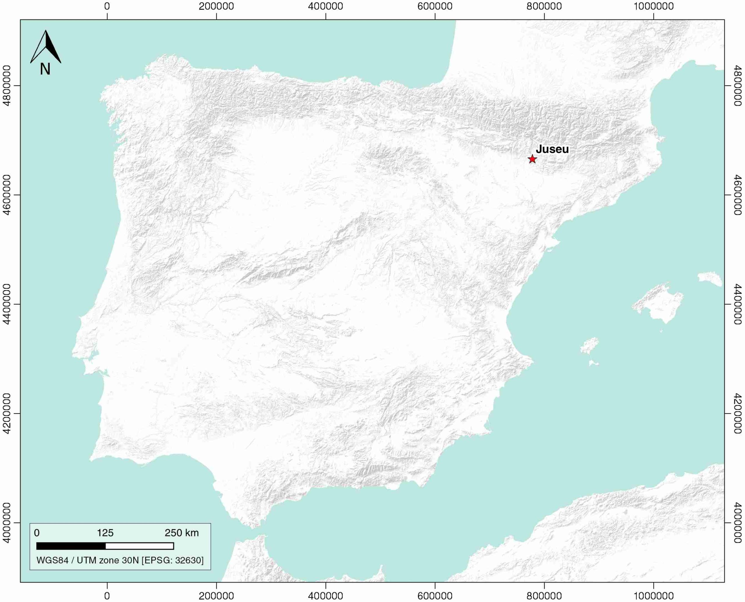
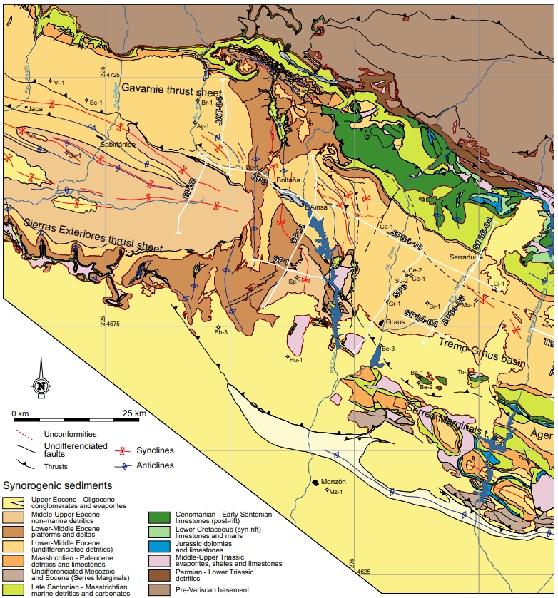
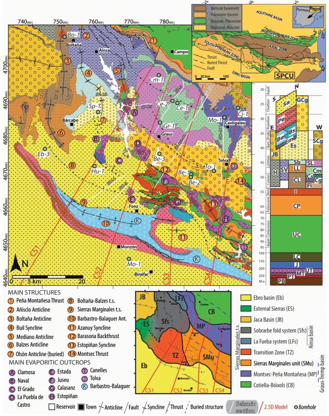
| Geological Setting | South Pyrenees Central Unit (Sierras Marginales; Boltaña-Balzes thrust sheet), Southern Pyrenees |
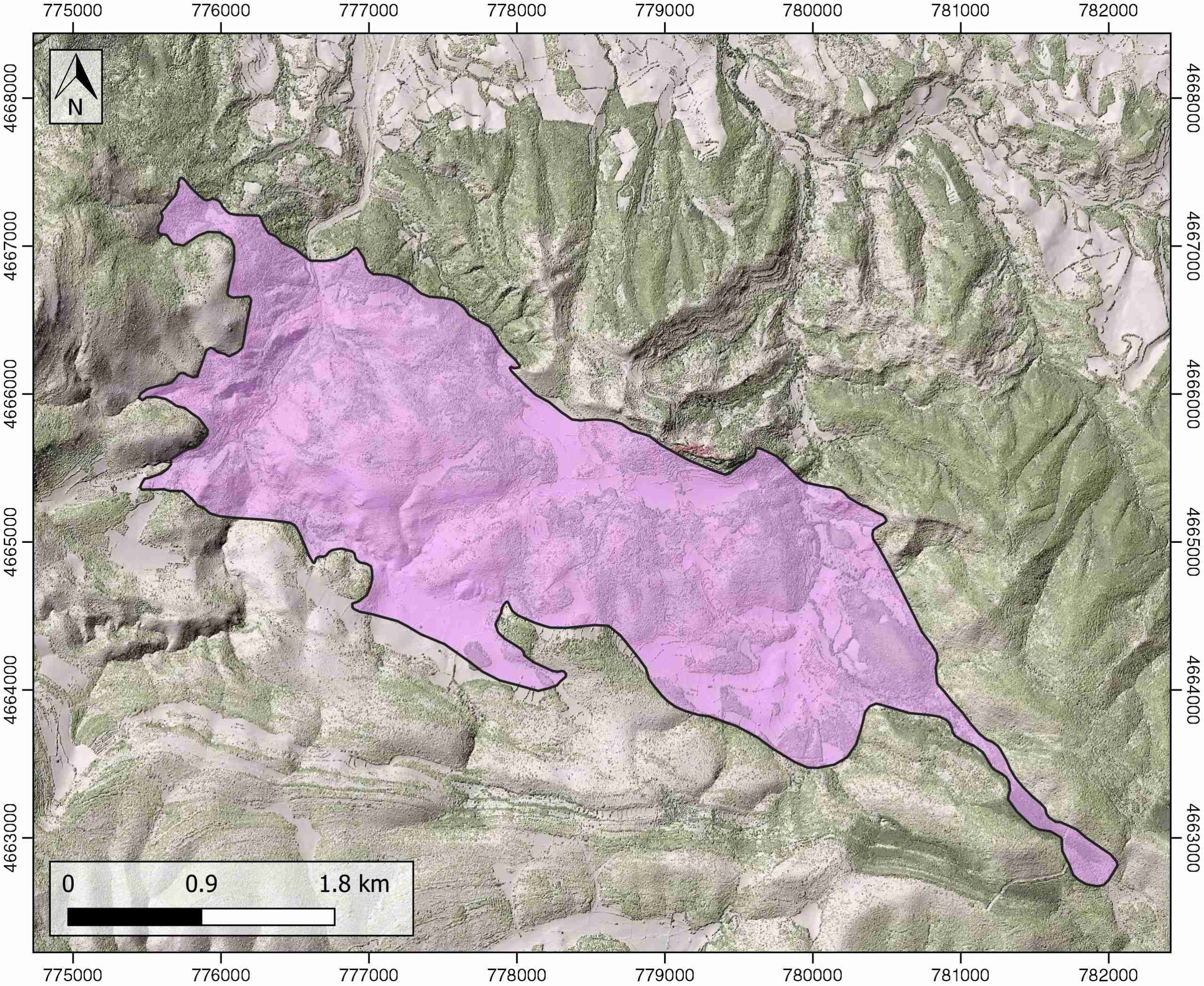
| Outcropping/buried | Outcropping |
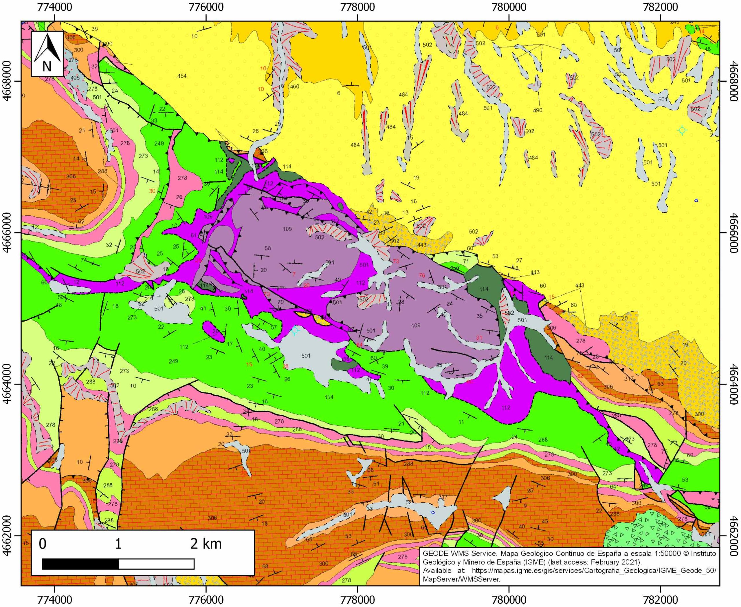
| Evaporite unit/s name | El Pont de Suert Fm. |
| Evaporite unit/s age | Upper Anisian and Carnian-Rhaetian (Middle-Upper Triassic) |
| Evaporite unit/s origin | Marine |
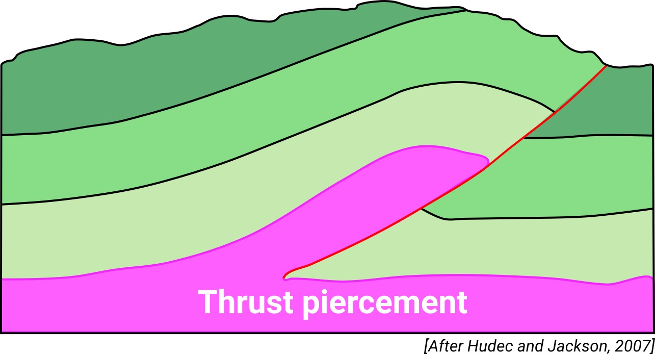
| Classif. (Hudec and Jackson, 2009) | Thrust piercement |
| Classif. (Jackson and Talbot, 1986) | Salt wall |
| Age of evaporite flow or deformation (when deformed) | Eocene, Oligocene to Miocene |
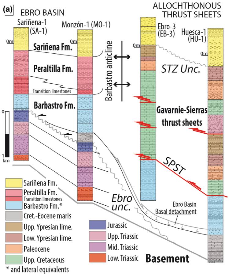
| Other comments | Subsurface occurrence of the Eocene evaporites of the Barbastro Formation beneath the diapir. |
Generic Data
| Unique ID | 73 |
| Name | Juseu |
| Structure type | Evaporite diapir |
| Deformed/Undeformed | Deformed |
| Buried/Outcropping | Outcropping |
| Geological setting | Southern Pyrenees |
| Geological Regional Setting | South Pyrenees Central Unit (Sierras Marginales; Boltaña-Balzes thrust sheet) |
| Evaporite unit/s name | El Pont de Suert Fm. (Middle Muschelkalk and Keuper Facies) |
| Evaporite unit/s age | Upper Anisian and Carnian-Rhaetian (Middle-Upper Triassic) |
| Evaporite unit/s era | Mesozoic |
| Evaporite unit/s origin | Marine |
| Evaporite unit/s composition | Shale-Gypsum-Anhydrite-Halite |
| Post-kinematic unit/s (or post-evaporite units when evaporites are undeformed) | Quaternary (alluvial and colluvial detrital deposits) |
| Post-kinematic unit/s age (or post-evaporite units when evaporites are undeformed) | Pleistocene-Holocene |
| Classification (Hudec and Jackson, 2009) | Thrust piercement |
| Classification (Jackson and Talbot, 1986) | Salt wall |
| Mining activity? | Y |
| Mining activity start | – |
| Mining activity end | – |
| Mining galleries? | – |
| Mining products | Ophites |
| Mining sub-products | – |
| Evaporite flow? | Y |
| Age of evaporite flow | Lutetian-Priabonian (early stage) ; Late Oligocene-Early Miocene (late stage) |
| Flow or deformation triggering mechanisms | Translation–rotation of the western end of the Sierras Marginales thrust sheet (early stage) and regional compression (late stage) |
| Flow-linked structures? | Y |
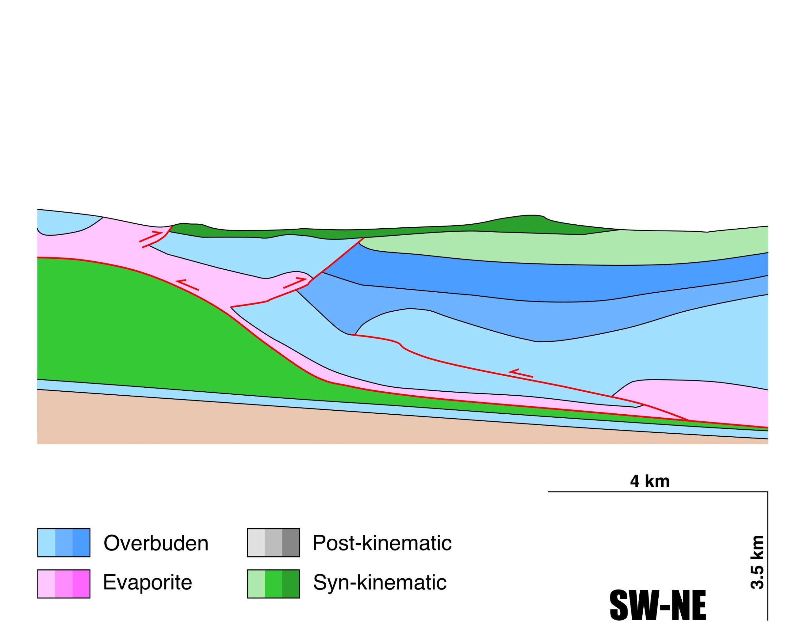
| Halokinetic structures | Normal high-angle faults / thrust faults / thickness variations / Progressive Unconformities |
| Post-evaporite and pre-kinematic unit/s (overbuden) | Lower Jurassic (limestones, dolostones and shales) ; Upper Santonian-Maastrichtian (calcarenites and limestones) ; Maastrichian-Paleocene (Garumn Facies, carbonates and shales) ; Palaeocene-Lower Eocene (shallow marines carbonates) ; Upper Eocene-Oligocene (evaporites and detrital deposits) |
| Syn-kinematic unit/s | Lutetian-Early Priabonian (marlstones, mudstones, limestones, sandstones) ; Late Oligocene-Early Miocene (alluvial fan conglomerates) |
| Available seismic profiles | SP-84-02 / SP-10PROL / SP-10PROL / SP-84-02 / SP-10PROL / SP-50 / SP-84-02 / SP-10_PROL / SP-50 / SP-40 / ND-64 / SP-84-02 / SP-10_PROL / SP-40 / SP-40 / ND-108 / SP-10PROL / SP-09PROL / SP-10PROL / SP-50 / SP-50 |
| Available boreholes | ALER (ALER-BENABARRE) |
| Additional comments | Subsurface occurrence of the Eocene evaporites of the Barbastro Formation beneath the diapir |
Mining Data
| UNIQUE_ID | 73 |
| Minning exploitations within <2km? | Y |
| Historical/Active | Active |
| Exploitation name #1 | ESPALS |
| Exploitation ID (Spanish National Mining Cadastre) #1 | 203 |
| Municipality #1 | Graus |
| Province #1 | HUESCA |
| Company #1 | VIDAL OBRAS Y SERVICIOS, S.A. |
| Main minning Products #1 | Ophites |
| Exploitation name #2 | |
| Exploitation ID (Spanish National Mining Cadastre) #2 | |
| Municipality #2 | |
| Province #2 | |
| Company #2 | |
| Main minning Products #2 | |
| Exploitation name #3 | |
| Exploitation ID (Spanish National Mining Cadastre) #3 | |
| Municipality #3 | |
| Province #3 | |
| Company #3 | |
| Main minning Products #3 |
Quantitative Data
| UNIQUE_ID | 73 |
| Outcropping area (km2) | 9.22496 |
| Horizontal intersection area (km2) (when buried) | Not buried |
| Depth of intersection area (km2) (when buried) | Not buried |
| Max. Width (Km) | 2.83620544 |
| Max. Length (Km) | 7.45754178 |
| Max. Evaporites thickness (km) | 1.2 |
| Max. Deformation age (Ma) | 46 |
| Min. Deformation age (Ma) | 24 |
| Deformation stages | 2 |
Reference Data
| UNIQUE_ID | 73 |
| Section source | Santolaria, P., Casas-Sainz, A. M., Soto, R., Casas, A., 2017. Gravity modelling to assess salt tectonics in the western end of the South Pyrenean Central Unit. Journal of the Geological Society, 174(2), 269-288. [link] |
| Well / Borehole availability #1 | Martín-Chivelet, J., López-Gómez, J., Aguado, R., Arias, C., Arribas, J., Arribas, M. E., … , Casas-Sainz, A., 2019. The Late Jurassic–Early Cretaceous Rifting. In (Quesada C., Oliveira J., eds.): The Geology of Iberia: A Geodynamic Approach. Regional Geology Reviews. Springer, Cham. [link] |
| Well / Borehole availability #2 | Cámara, P., Flinch, J. F., 2017. The southern Pyrenees: a salt-based fold-and-thrust belt. In Permo-Triassic Salt Provinces of Europe, North Africa and the Atlantic Margins (pp. 395-415). Elsevier. [link] |
| Available data (Stratigraphy) #1 | Salvany, J. M., Bastida, J., 2004. Análisis litoestratigráfico del Keuper surpirenaico central. Revista de la Sociedad Geológica de España, 17(1), 3-26. [link] |
| Available data (Stratigraphy) #2 | Millán-Garrido, H., Morer, E. P., Cardona, M. A., Aguado, A. L., Urcia, B. O., Peña, B. M., 2000. Actividad tectónica registrada en los depósitos terciarios del frente meridional del Pirineo central. Revista de la Sociedad Geológica de España, 13(2), 279-300. [link] |
| Available data (Stratigraphy) #3 | Santolaria, P., Ayala, C., Pueyo, E. L., Rubio, F. M., Soto, R., Calvín, P., …, Casas‐Sainz, A. M., 2020. Structural and geophysical characterization of the western termination of the South Pyrenean triangle zone. Tectonics, 39(8), e2019TC005891. [link] |
| Available data (Stratigraphy) #4 | Cámara, P., Flinch, J. F., 2017. The southern Pyrenees: a salt-based fold-and-thrust belt. In Permo-Triassic Salt Provinces of Europe, North Africa and the Atlantic Margins (pp. 395-415). Elsevier. [link] |
| Available data (Stratigraphy) #5 | Muñoz, J. A., Mencos, J., Roca, E., Carrera, N., Gratacós, O., Ferrer, O., Fernández, O., 2018. The structure of the South-Central-Pyrenean fold and thrust belt as constrained by subsurface data. Geologica Acta, 16(4), 439-460. [link] |
| Available data (Stratigraphy) #6 | Martín-Chivelet, J., López-Gómez, J., Aguado, R., Arias, C., Arribas, J., Arribas, M. E., … , Casas-Sainz, A., 2019. The Late Jurassic–Early Cretaceous Rifting. In (Quesada C., Oliveira J., eds.): The Geology of Iberia: A Geodynamic Approach. Regional Geology Reviews. Springer, Cham. [link] |
| Regional Stratigraphy | Santolaria, P., Ayala, C., Pueyo, E. L., Rubio, F. M., Soto, R., Calvín, P., …, Casas‐Sainz, A. M., 2020. Structural and geophysical characterization of the western termination of the South Pyrenean triangle zone. Tectonics, 39(8), e2019TC005891. [link] |
| Seismic data availability #1 | Santolaria, P., Casas-Sainz, A. M., Soto, R., Casas, A., 2017. Gravity modelling to assess salt tectonics in the western end of the South Pyrenean Central Unit. Journal of the Geological Society, 174(2), 269-288. [link] |
| Seismic data availability #2 | Cámara, P., Flinch, J. F., 2017. The southern Pyrenees: a salt-based fold-and-thrust belt. In Permo-Triassic Salt Provinces of Europe, North Africa and the Atlantic Margins (pp. 395-415). Elsevier. [link] |
| Seismic data availability #3 | n.a. |
| Available data (Structure) #1 | Santolaria, P., Casas-Sainz, A. M., Soto, R., Casas, A., 2017. Gravity modelling to assess salt tectonics in the western end of the South Pyrenean Central Unit. Journal of the Geological Society, 174(2), 269-288. [link] |
| Available data (Structure) #2 | Santolaria, P., Ayala, C., Pueyo, E. L., Rubio, F. M., Soto, R., Calvín, P., …, Casas‐Sainz, A. M., 2020. Structural and geophysical characterization of the western termination of the South Pyrenean triangle zone. Tectonics, 39(8), e2019TC005891. [link] |
| Available data (Structure) #3 | Santolaria, P., Casas-Sainz, A. M., 2013. Estructura y cinemática del sector occidental de las Sierras Marginales (Unidad Surpirenaica Central). Geogaceta, 53, 69-72. [link] |
| Available data (Structure) #4 | Santolaria, P., Calvín, P., Soto Marín, R. L., Casas, A. M., Luzón Aguado, M. A., Pueyo Morer, E. L., 2016. Nuevas aportaciones sobre la estructura de la terminación occidental del anticlinal de Barbastro-Balaguer. Geotemas, 16, 77-80. [link] |
| Available data (Structure) #5 | Senz, J. G., Zamorano, M., 1992. Evolución tectónica y sedimentaria durante el Priaboniense superior-Mioceno inferior, en el frente de cabalgamiento de las Sierras Marginales occidentales. Acta geológica hispánica, 27(1-2), 195-209. [link] |
| Available data (Structure) #6 | Cámara, P., Flinch, J. F., 2017. The southern Pyrenees: a salt-based fold-and-thrust belt. In Permo-Triassic Salt Provinces of Europe, North Africa and the Atlantic Margins (pp. 395-415). Elsevier. [link] |
| Available data (Analogue modelling) #1 | n.a. |
| Available data (Analogue modelling) #2 | n.a. |
| Available data (Analogue modelling) #3 | n.a. |
| Available data (Gravimetry – Tomography) #1 | Santolaria, P., Casas-Sainz, A. M., Soto, R., Casas, A., 2017. Gravity modelling to assess salt tectonics in the western end of the South Pyrenean Central Unit. Journal of the Geological Society, 174(2), 269-288. [link] |
| Available data (Gravimetry – Tomography) #2 | Casas, A., Santolaria, P., Rivero, L., Casas-Sainz, A., Himi, M., Pinto, V., Sendrós, A., 2016. The gravity method: new challenges for delineation diapiric structures in north-east Spain. First Break, 34(8). [link] |
| Available data (Gravimetry – Tomography) #3 | n.a. |
| Available data (Geochemistry) #1 | Salvany, J. M., Bastida, J., 2004. Análisis litoestratigráfico del Keuper surpirenaico central. Revista de la Sociedad Geológica de España, 17(1), 3-26. [link] |
| Available data (Geochemistry) #2 | Gómez-Gras, D., Roigé, M., Fondevilla, V., Oms, O., Boya, S., Remacha, E., 2016. Provenance constraints on the Tremp Formation paleogeography (southern Pyrenees): Ebro Massif vs Pyrenees sources. Cretaceous Research, 57, 414-427. [link] |
| Available data (Geochemistry) #3 | n.a. |
| Available data (Geochemistry) #4 | n.a. |
| Available data (Petrophysics) #1 | Santolaria, P., Casas-Sainz, A. M., Soto, R., Casas, A., 2017. Gravity modelling to assess salt tectonics in the western end of the South Pyrenean Central Unit. Journal of the Geological Society, 174(2), 269-288. [link] |
| Available data (Petrophysics) #2 | Muñoz, J. A., Beamud, E., Fernández, O., Arbués, P., Dinarès‐Turell, J., Poblet, J., 2013. The Ainsa Fold and thrust oblique zone of the central Pyrenees: Kinematics of a curved contractional system from paleomagnetic and structural data. Tectonics, 32(5), 1142-1175. [link] |
| IGME Geological Map (MAGNA50) Sheet number | 288-Fonz. [link] |
| Other Maps #1 (source) | Muñoz, J. A., Mencos, J., Roca, E., Carrera, N., Gratacós, O., Ferrer, O., Fernández, O., 2018. The structure of the South-Central-Pyrenean fold and thrust belt as constrained by subsurface data. Geologica Acta, 16(4), 439-460. [link] |
| Other Maps #2 (source) | Santolaria, P., Casas-Sainz, A. M., Soto, R., Casas, A., 2017. Gravity modelling to assess salt tectonics in the western end of the South Pyrenean Central Unit. Journal of the Geological Society, 174(2), 269-288. [link] |
| Other related references #1 | Lanaja, J.M., 1987. Contribución de la exploración petrolífera al conocimiento de la geología de España. Instituto Geológico y Minero de España, 465 p. [link] |
| Other related references #2 | Salvany, J. M., 1999. Diapirismo triásico antiguo y reciente en el anticlinal de Canelles, Sierras Marginales Catalanas. Revista de la Sociedad Geológica de España, 12(2), 149-163. [link] |
| Other related references #3 | Arenas, C., Millán, H., Pardo, G., Pocoví, A., 2001. Ebro Basin continental sedimentation associated with late compressional Pyrenean tectonics (north‐eastern Iberia): controls on basin margin fans and fluvial systems. Basin Research, 13(1), 65-89. [link] |
| Other related references #4 | Balaguer, J. F., Casas-Sainz, A. M., 2016. Estructura de la terminación occidental del cabalgamiento del Montsec (Pirineos Centrales). Revista de la Sociedad Geológica de España, 29(2), 39-56. [link] |
Well and Seismic Data
| UNIQUE_ID | 73 |
| Seismic survey name #1 | 11D1-QUEROL-SP-84 |
| Across structure? #1 | Y |
| Seismic profile ID (IGME) #1 | 10241 |
| Seismic profile code #1 | 14869 |
| Seismic profile name #1 | SP-84-02 |
| Seismic survey year #1 | 1984 |
| Data repository #1 | SIGEOF Data Catalogue (Section available under request). ©Instituto Geológico y Minero de España (IGME). https://info.igme.es/SIGEOF/ |
| Length (km) #1 | 18.20 |
| Seismic survey name #2 | 0116A80G |
| Across structure? #2 | Y |
| Seismic profile ID (IGME) #2 | 5362 |
| Seismic profile code #2 | 7730 |
| Seismic profile name #2 | SP-10PROL |
| Seismic survey year #2 | 1980 |
| Data repository #2 | SIGEOF Data Catalogue (Private access section). ©Instituto Geológico y Minero de España (IGME). https://info.igme.es/SIGEOF/ |
| Length (km) #2 | 27.83 |
| Seismic survey name #3 | 0116A80S |
| Across structure? #3 | Y |
| Seismic profile ID (IGME) #3 | 5492 |
| Seismic profile code #3 | 8394 |
| Seismic profile name #3 | SP-10PROL |
| Seismic survey year #3 | 1980 |
| Data repository #3 | SIGEOF Data Catalogue (Private access section). ©Instituto Geológico y Minero de España (IGME). https://info.igme.es/SIGEOF/ |
| Length (km) #3 | 20.80 |
| Seismic survey name #4 | 0355A84G |
| Across structure? #4 | Y |
| Seismic profile ID (IGME) #4 | 4074 |
| Seismic profile code #4 | 5542 |
| Seismic profile name #4 | SP-84-02 |
| Seismic survey year #4 | 1984 |
| Data repository #4 | SIGEOF Data Catalogue (Private access section). ©Instituto Geológico y Minero de España (IGME). https://info.igme.es/SIGEOF/ |
| Length (km) #4 | 18.17 |
| Seismic survey name #5 | 0116A80U |
| Across structure? #5 | Y |
| Seismic profile ID (IGME) #5 | 5527 |
| Seismic profile code #5 | 8429 |
| Seismic profile name #5 | SP-10PROL |
| Seismic survey year #5 | 1980 |
| Data repository #5 | SIGEOF Data Catalogue (Private access section). ©Instituto Geológico y Minero de España (IGME). https://info.igme.es/SIGEOF/ |
| Length (km) #5 | 17.29 |
| Seismic survey name #6 | 0116A80G |
| Across structure? #6 | Y |
| Seismic profile ID (IGME) #6 | 5386 |
| Seismic profile code #6 | 7754 |
| Seismic profile name #6 | SP-50 |
| Seismic survey year #6 | 1980 |
| Data repository #6 | SIGEOF Data Catalogue (Private access section). ©Instituto Geológico y Minero de España (IGME). https://info.igme.es/SIGEOF/ |
| Length (km) #6 | 5.85 |
| Seismic survey name #7 | 0355A84S |
| Across structure? #7 | Y |
| Seismic profile ID (IGME) #7 | 5397 |
| Seismic profile code #7 | 7781 |
| Seismic profile name #7 | SP-84-02 |
| Seismic survey year #7 | 1984 |
| Data repository #7 | SIGEOF Data Catalogue (Private access section). ©Instituto Geológico y Minero de España (IGME). https://info.igme.es/SIGEOF/ |
| Length (km) #7 | 18.26 |
| Seismic survey name #8 | 11D1-SP |
| Across structure? #8 | Y |
| Seismic profile ID (IGME) #8 | 10274 |
| Seismic profile code #8 | 14902 |
| Seismic profile name #8 | SP-10_PROL |
| Seismic survey year #8 | 1962 |
| Data repository #8 | SIGEOF Data Catalogue (Section available under request). ©Instituto Geológico y Minero de España (IGME). https://info.igme.es/SIGEOF/ |
| Length (km) #8 | 25.32 |
| Seismic survey name #9 | 11D1-SP |
| Across structure? #9 | Y |
| Seismic profile ID (IGME) #9 | 10259 |
| Seismic profile code #9 | 14887 |
| Seismic profile name #9 | SP-50 |
| Seismic survey year #9 | 1979 |
| Data repository #9 | SIGEOF Data Catalogue (Private access section). ©Instituto Geológico y Minero de España (IGME). https://info.igme.es/SIGEOF/ |
| Length (km) #9 | 5.68 |
| Seismic survey name #10 | 11D1-SP |
| Across structure? #10 | N (within 3km) |
| Seismic profile ID (IGME) #10 | 10266 |
| Seismic profile code #10 | 14894 |
| Seismic profile name #10 | SP-40 |
| Seismic survey year #10 | 1962 |
| Data repository #10 | SIGEOF Data Catalogue (Section available under request). ©Instituto Geológico y Minero de España (IGME). https://info.igme.es/SIGEOF/ |
| Length (km) #10 | 7.80 |
| Seismic survey name #11 | 11D1-ND |
| Across structure? #11 | N (within 3km) |
| Seismic profile ID (IGME) #11 | 10148 |
| Seismic profile code #11 | 14776 |
| Seismic profile name #11 | ND-64 |
| Seismic survey year #11 | 1962 |
| Data repository #11 | SIGEOF Data Catalogue (Section available under request). ©Instituto Geológico y Minero de España (IGME). https://info.igme.es/SIGEOF/ |
| Length (km) #11 | 13.83 |
| Seismic survey name #12 | 11D1-QUEROL-SP-84 |
| Across structure? #12 | N (within 3km) |
| Seismic profile ID (IGME) #12 | 10241 |
| Seismic profile code #12 | 14869 |
| Seismic profile name #12 | SP-84-02 |
| Seismic survey year #12 | 1984 |
| Data repository #12 | SIGEOF Data Catalogue (Section available under request). ©Instituto Geológico y Minero de España (IGME). https://info.igme.es/SIGEOF/ |
| Length (km) #12 | 18.20 |
| Seismic survey name #13 | 11D1-SP |
| Across structure? #13 | N (within 3km) |
| Seismic profile ID (IGME) #13 | 10274 |
| Seismic profile code #13 | 14902 |
| Seismic profile name #13 | SP-10_PROL |
| Seismic survey year #13 | 1962 |
| Data repository #13 | SIGEOF Data Catalogue (Section available under request). ©Instituto Geológico y Minero de España (IGME). https://info.igme.es/SIGEOF/ |
| Length (km) #13 | 25.32 |
| Seismic survey name #14 | 0116A80U |
| Across structure? #14 | N (within 3km) |
| Seismic profile ID (IGME) #14 | 5543 |
| Seismic profile code #14 | 8445 |
| Seismic profile name #14 | SP-40 |
| Seismic survey year #14 | 1980 |
| Data repository #14 | SIGEOF Data Catalogue (Private access section). ©Instituto Geológico y Minero de España (IGME). https://info.igme.es/SIGEOF/ |
| Length (km) #14 | 9.49 |
| Seismic survey name #15 | 0116A80G |
| Across structure? #15 | N (within 3km) |
| Seismic profile ID (IGME) #15 | 5381 |
| Seismic profile code #15 | 7749 |
| Seismic profile name #15 | SP-40 |
| Seismic survey year #15 | 1980 |
| Data repository #15 | SIGEOF Data Catalogue (Private access section). ©Instituto Geológico y Minero de España (IGME). https://info.igme.es/SIGEOF/ |
| Length (km) #15 | 9.59 |
| Seismic survey name #16 | 11D1-ND |
| Across structure? #16 | N (within 3km) |
| Seismic profile ID (IGME) #16 | 10216 |
| Seismic profile code #16 | 14844 |
| Seismic profile name #16 | ND-108 |
| Seismic survey year #16 | 1962 |
| Data repository #16 | SIGEOF Data Catalogue (Private access section). ©Instituto Geológico y Minero de España (IGME). https://info.igme.es/SIGEOF/ |
| Length (km) #16 | 7.92 |
| Seismic survey name #17 | 0116A80G |
| Across structure? #17 | N (within 3km) |
| Seismic profile ID (IGME) #17 | 5362 |
| Seismic profile code #17 | 7730 |
| Seismic profile name #17 | SP-10PROL |
| Seismic survey year #17 | 1980 |
| Data repository #17 | SIGEOF Data Catalogue (Private access section). ©Instituto Geológico y Minero de España (IGME). https://info.igme.es/SIGEOF/ |
| Length (km) #17 | 27.83 |
| Seismic survey name #18 | 0116A80G |
| Across structure? #18 | N (within 3km) |
| Seismic profile ID (IGME) #18 | 5361 |
| Seismic profile code #18 | 7729 |
| Seismic profile name #18 | SP-09PROL |
| Seismic survey year #18 | 1980 |
| Data repository #18 | SIGEOF Data Catalogue (Private access section). ©Instituto Geológico y Minero de España (IGME). https://info.igme.es/SIGEOF/ |
| Length (km) #18 | 7.78 |
| Seismic survey name #19 | 0116A80U |
| Across structure? #19 | N (within 3km) |
| Seismic profile ID (IGME) #19 | 5527 |
| Seismic profile code #19 | 8429 |
| Seismic profile name #19 | SP-10PROL |
| Seismic survey year #19 | 1980 |
| Data repository #19 | SIGEOF Data Catalogue (Private access section). ©Instituto Geológico y Minero de España (IGME). https://info.igme.es/SIGEOF/ |
| Length (km) #19 | 17.29 |
| Seismic survey name #20 | 0116A80U |
| Across structure? #20 | N (within 3km) |
| Seismic profile ID (IGME) #20 | 5548 |
| Seismic profile code #20 | 8450 |
| Seismic profile name #20 | SP-50 |
| Seismic survey year #20 | 1980 |
| Data repository #20 | SIGEOF Data Catalogue (Private access section). ©Instituto Geológico y Minero de España (IGME). https://info.igme.es/SIGEOF/ |
| Length (km) #20 | 3.09 |
| Seismic survey name #21 | 0116A80G |
| Across structure? #21 | N (within 3km) |
| Seismic profile ID (IGME) #21 | 5386 |
| Seismic profile code #21 | 7754 |
| Seismic profile name #21 | SP-50 |
| Seismic survey year #21 | 1980 |
| Data repository #21 | SIGEOF Data Catalogue (Private access section). ©Instituto Geológico y Minero de España (IGME). https://info.igme.es/SIGEOF/ |
| Length (km) #21 | 5.85 |
| Borehole name #1 | ALER (ALER-BENABARRE) |
| Company #1 | CONFEDERACION HIDROGRAFICA DEL EBRO |
| Traget #1 | HYDROGEOLOGY |
| Across structure? #1 | N (within 5 km) |
| Borehole name #2 | |
| Company #2 | |
| Traget #2 | |
| Across structure? #2 | |
| Borehole name #3 | |
| Company #3 | |
| Traget #3 | |
| Across structure? #3 | |
| Borehole name #4 | |
| Company #4 | |
| Traget #4 | |
| Across structure? #4 | |
| Borehole name #5 | |
| Company #5 | |
| Traget #5 | |
| Across structure? #5 | |
| Borehole name #6 | |
| Company #6 | |
| Traget #6 | |
| Across structure? #6 | |
| Borehole name #7 | |
| Company #7 | |
| Traget #7 | |
| Across structure? #7 | |
| Borehole name #8 | |
| Company #8 | |
| Traget #8 | |
| Across structure? #8 | |
| Borehole name #9 | |
| Company #9 | |
| Traget #9 | |
| Across structure? #9 | |
| Borehole name #10 | |
| Company #10 | |
| Traget #10 | |
| Across structure? #10 | |
| Borehole name #11 | |
| Company #11 | |
| Traget #11 | |
| Across structure? #11 | |
| Borehole name #12 | |
| Company #12 | |
| Traget #12 | |
| Across structure? #12 | |
| Borehole name #13 | |
| Company #13 | |
| Traget #13 | |
| Across structure? #13 | |
| Borehole name #14 | |
| Company #14 | |
| Traget #14 | |
| Across structure? #14 | |
| Borehole name #15 | |
| Company #15 | |
| Traget #15 | |
| Across structure? #15 |
Geographical Data (EPSG:4326 - WGS 84)
| UNIQUE_ID | 73 |
| X Centroid (Structure shape) | 0.363736 |
| Y Centroid (Structure shape) | 0.363736 |
| Xmin (Structure shape) | 0.330632 |
| Xmax (Structure shape) | 0.409167 |
| Ymin (Structure shape) | 42.065526 |
| Ymax (Structure shape) | 42.110770 |
| Xmin seismic line #1 | 0.318439 |
| Xmax seismic line #1 | 0.442441 |
| Ymin seismic line #1 | 42.073125 |
| Ymax seismic line #1 | 42.208446 |
| Xmin seismic line #2 | 0.276069 |
| Xmax seismic line #2 | 0.464405 |
| Ymin seismic line #2 | 41.994966 |
| Ymax seismic line #2 | 42.195640 |
| Xmin seismic line #3 | 0.321820 |
| Xmax seismic line #3 | 0.462766 |
| Ymin seismic line #3 | 42.042025 |
| Ymax seismic line #3 | 42.194335 |
| Xmin seismic line #4 | 0.318681 |
| Xmax seismic line #4 | 0.442071 |
| Ymin seismic line #4 | 42.073330 |
| Ymax seismic line #4 | 42.208472 |
| Xmin seismic line #5 | 0.350153 |
| Xmax seismic line #5 | 0.463599 |
| Ymin seismic line #5 | 42.069137 |
| Ymax seismic line #5 | 42.195640 |
| Xmin seismic line #6 | 0.350514 |
| Xmax seismic line #6 | 0.377737 |
| Ymin seismic line #6 | 42.103638 |
| Ymax seismic line #6 | 42.152250 |
| Xmin seismic line #7 | 0.318792 |
| Xmax seismic line #7 | 0.440349 |
| Ymin seismic line #7 | 42.073524 |
| Ymax seismic line #7 | 42.206668 |
| Xmin seismic line #8 | 0.282745 |
| Xmax seismic line #8 | 0.458239 |
| Ymin seismic line #8 | 42.006030 |
| Ymax seismic line #8 | 42.190745 |
| Xmin seismic line #9 | 0.344744 |
| Xmax seismic line #9 | 0.371735 |
| Ymin seismic line #9 | 42.102860 |
| Ymax seismic line #9 | 42.149813 |
| Xmin seismic line #10 | 0.422882 |
| Xmax seismic line #10 | 0.462334 |
| Ymin seismic line #10 | 42.069837 |
| Ymax seismic line #10 | 42.132964 |
| Xmin seismic line #11 | 0.431154 |
| Xmax seismic line #11 | 0.478279 |
| Ymin seismic line #11 | 42.054254 |
| Ymax seismic line #11 | 42.163132 |
| Xmin seismic line #12 | 0.318439 |
| Xmax seismic line #12 | 0.442441 |
| Ymin seismic line #12 | 42.073125 |
| Ymax seismic line #12 | 42.208446 |
| Xmin seismic line #13 | 0.282745 |
| Xmax seismic line #13 | 0.458239 |
| Ymin seismic line #13 | 42.006030 |
| Ymax seismic line #13 | 42.190745 |
| Xmin seismic line #14 | 0.427627 |
| Xmax seismic line #14 | 0.474628 |
| Ymin seismic line #14 | 42.071247 |
| Ymax seismic line #14 | 42.147581 |
| Xmin seismic line #15 | 0.427627 |
| Xmax seismic line #15 | 0.474628 |
| Ymin seismic line #15 | 42.071247 |
| Ymax seismic line #15 | 42.147581 |
| Xmin seismic line #16 | 0.411997 |
| Xmax seismic line #16 | 0.471886 |
| Ymin seismic line #16 | 42.094034 |
| Ymax seismic line #16 | 42.147686 |
| Xmin seismic line #17 | 0.276069 |
| Xmax seismic line #17 | 0.464405 |
| Ymin seismic line #17 | 41.994966 |
| Ymax seismic line #17 | 42.195640 |
| Xmin seismic line #18 | 0.349709 |
| Xmax seismic line #18 | 0.437155 |
| Ymin seismic line #18 | 42.106416 |
| Ymax seismic line #18 | 42.131639 |
| Xmin seismic line #19 | 0.350153 |
| Xmax seismic line #19 | 0.463599 |
| Ymin seismic line #19 | 42.069137 |
| Ymax seismic line #19 | 42.195640 |
| Xmin seismic line #20 | 0.360348 |
| Xmax seismic line #20 | 0.377737 |
| Ymin seismic line #20 | 42.129362 |
| Ymax seismic line #20 | 42.152250 |
| Xmin seismic line #21 | 0.350514 |
| Xmax seismic line #21 | 0.377737 |
| Ymin seismic line #21 | 42.103638 |
| Ymax seismic line #21 | 42.152250 |
| X borehole #1 | 0.425161 |
| Y borehole #1 | 42.117590 |
| X borehole #2 | |
| Y borehole #2 | |
| X borehole #3 | |
| Y borehole #3 | |
| X borehole #4 | |
| Y borehole #4 | |
| X borehole #5 | |
| Y borehole #5 | |
| X borehole #6 | |
| Y borehole #6 | |
| X borehole #7 | |
| Y borehole #7 | |
| X borehole #8 | |
| Y borehole #8 | |
| X borehole #9 | |
| Y borehole #9 | |
| X borehole #10 | |
| Y borehole #10 | |
| X borehole #11 | |
| Y borehole #11 | |
| X borehole #12 | |
| Y borehole #12 | |
| X borehole #13 | |
| Y borehole #13 | |
| X borehole #14 | |
| Y borehole #14 | |
| X borehole #15 | |
| Y borehole #15 |

