General Information
| Structure type | Evaporite Diapir |
| Deformed/Undeformed | Deformed |
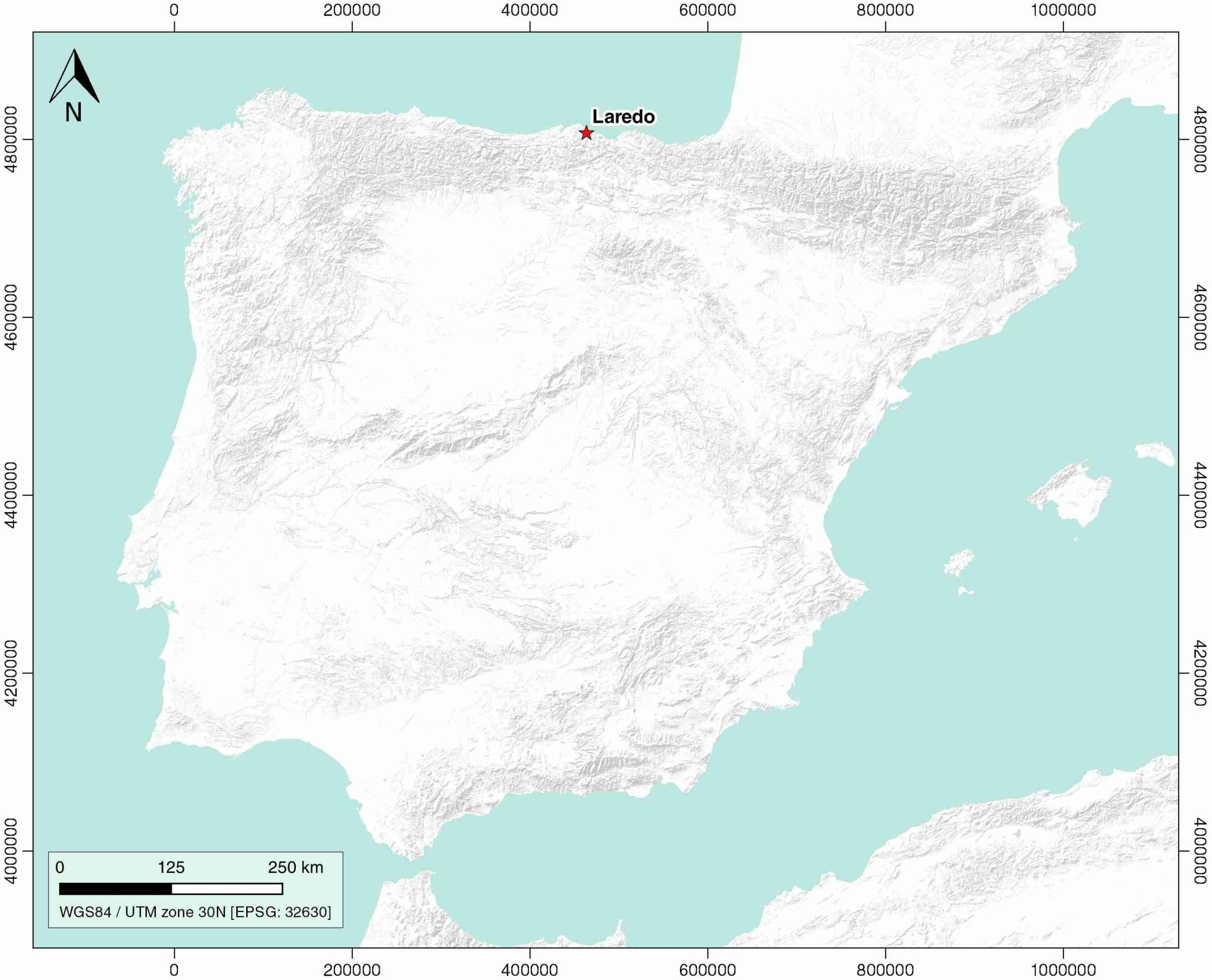
| Geological Setting | Basque-Cantabrian Basin, Cantabrian Block |
| Outcropping/buried | Outcropping |
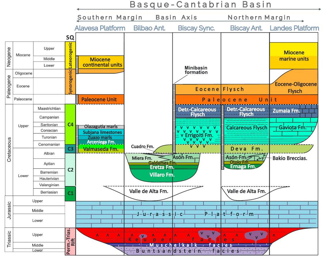
| Evaporite unit/s name | Keuper facies |
| Evaporite unit/s age | Carnian-Rhaetian (Upper Triassic) |
| Evaporite unit/s origin | Marine |
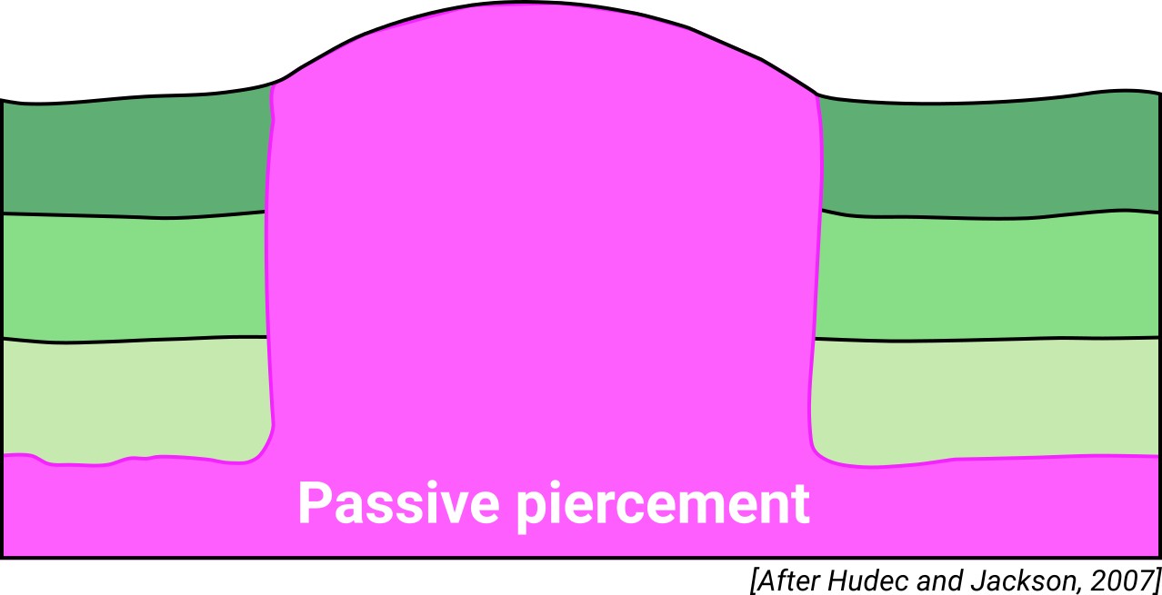
| Classif. (Hudec and Jackson, 2009) | Passive piercement |
| Classif. (Jackson and Talbot, 1986) | Salt stock |
| Age of evaporite flow or deformation (when deformed) | Lower Cretaceous, Oligocene to Miocene |
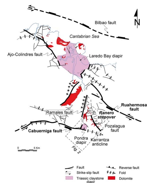
| Other comments | Hydrothermal fluid flow and dolomitization in diapiric-flexure areas (see López-Horgue et al., 2010). |
Generic Data
| Unique ID | 111 |
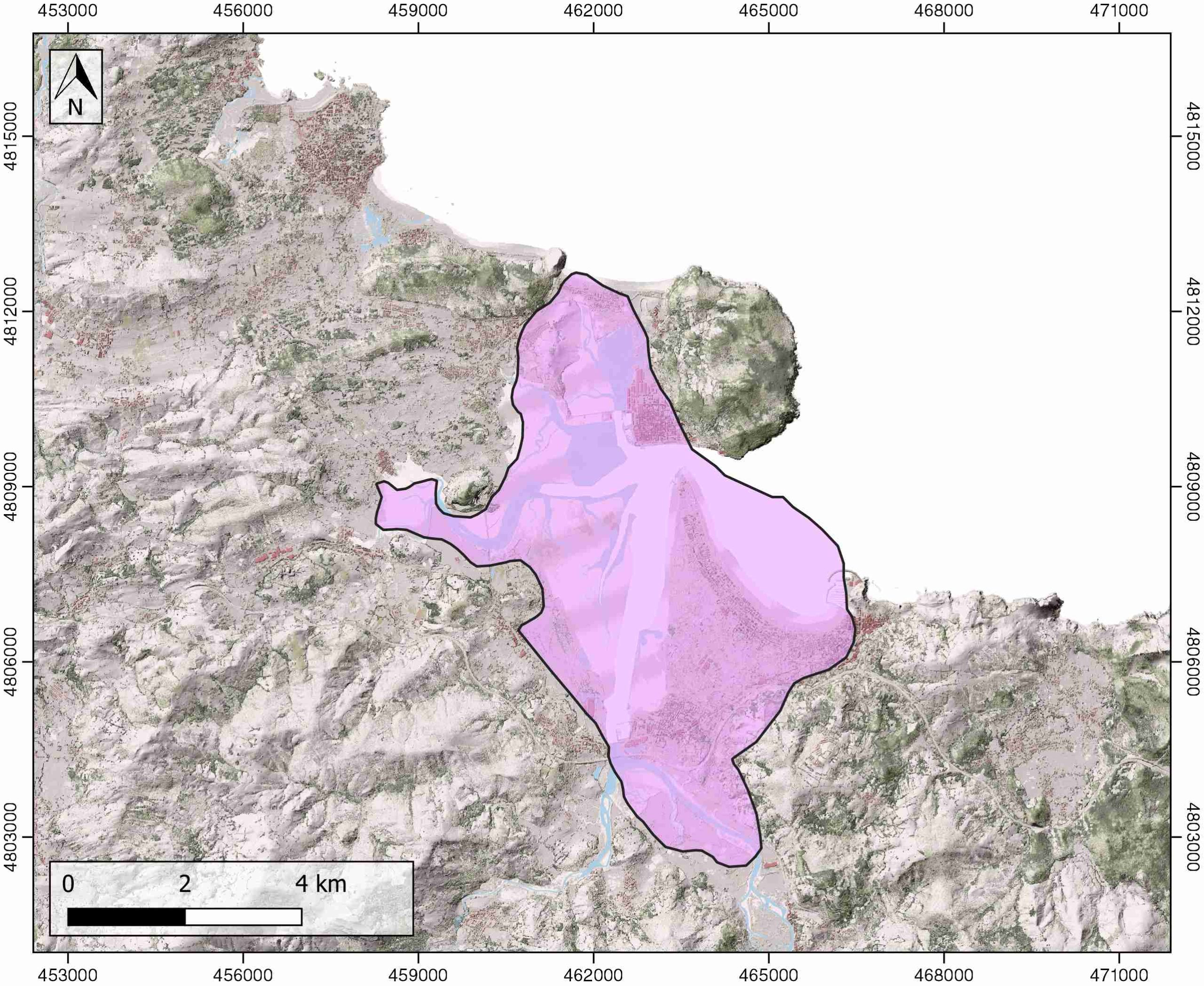
| Name | Laredo |
| Structure type | Evaporite diapir |
| Deformed/Undeformed | Deformed |
| Buried/Outcropping | Outcropping |
| Geological setting | Basque-Cantabrian Basin |
| Geological Regional Setting | Cantabrian Block |
| Evaporite unit/s name | Keuper facies |
| Evaporite unit/s age | Carnian-Rhaetian (Upper Triassic) |
| Evaporite unit/s era | Mesozoic |
| Evaporite unit/s origin | Marine |
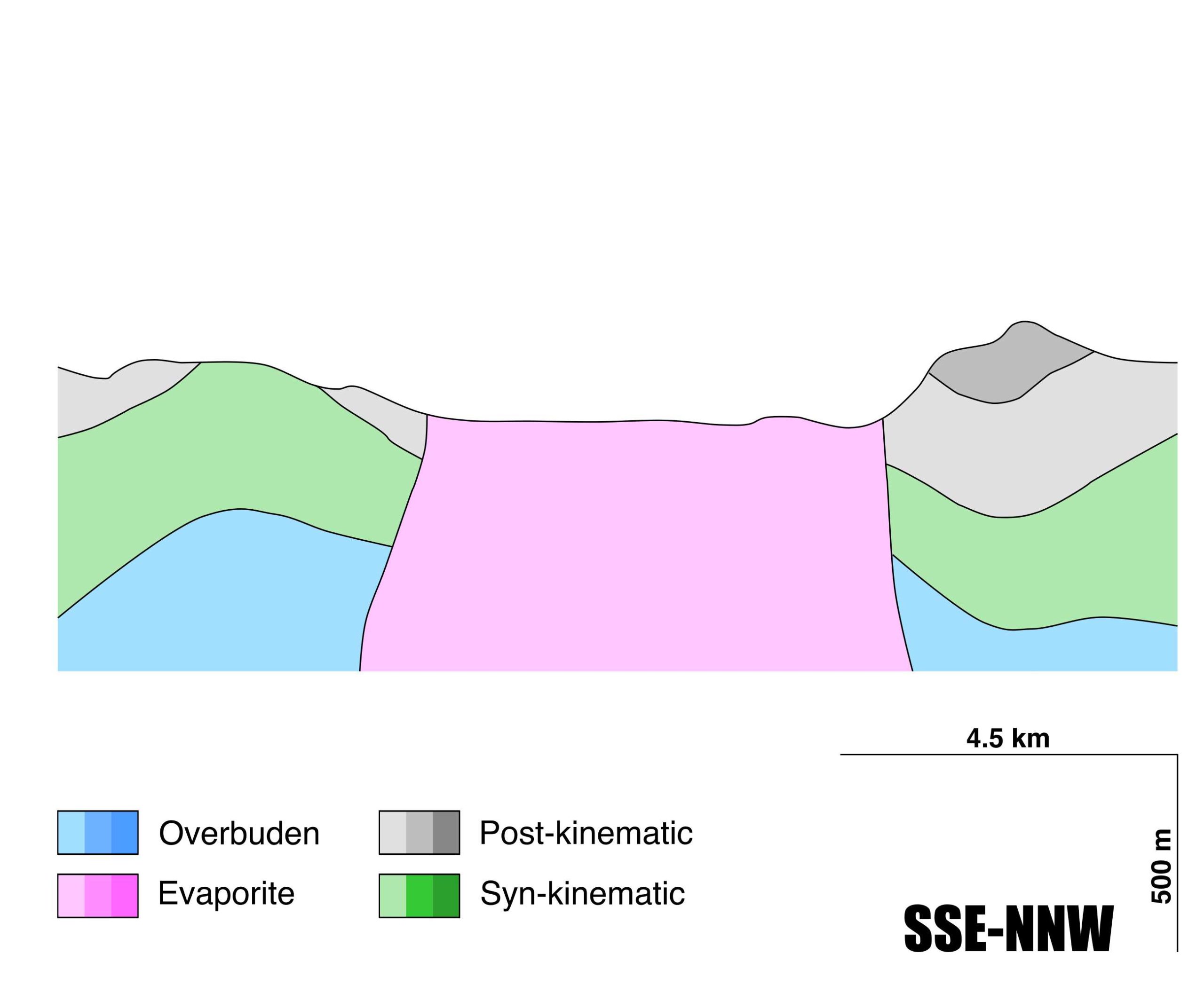
| Evaporite unit/s composition | Shale-Gypsum-Anhydrite-Ophites |
| Post-kinematic unit/s (or post-evaporite units when evaporites are undeformed) | Lower Cenomanian (sandstones, marlstones and limestones) ; Upper Cenomanian-Turonian (marlstones, limestones and marly limestones) ; Coniacian-Maastrichtian (limestones and marlstones) ; Quaternary (alluvial and colluvial detrital deposits) |
| Post-kinematic unit/s age (or post-evaporite units when evaporites are undeformed) | Coniacian-Holocene |
| Classification (Hudec and Jackson, 2009) | Passive piercement |
| Classification (Jackson and Talbot, 1986) | Salt stock |
| Mining activity? | Y |
| Mining activity start | – |
| Mining activity end | – |
| Mining galleries? | – |
| Mining products | Limestone (other uses) |
| Mining sub-products | – |
| Evaporite flow? | Y |
| Age of evaporite flow | Berriasian – Albian (early stage) and Oligocene – Miocene (late stage) |
| Flow or deformation triggering mechanisms | Mesozoic extensional regime in the Basque–Cantabrian Basin (listric faults and salt tectonics, early stage) and Tertiary compression (Coliendres-Ampuero fault zone; reverse faulting, reactivated salt diapirism and N-vergent salt sheets by low-angle trusting) |
| Flow-linked structures? | Y |
| Halokinetic structures | Normal high-angle faults / joints / thickness variations / progressive unconformities |
| Post-evaporite and pre-kinematic unit/s (overbuden) | Lower Jurassic (dolomitic brecchias, limestones and marls) |
| Syn-kinematic unit/s | Upper Valanginian-Barremian (limestones and claystones) ; Aptian-Albian (orbitolinid-rich limestones) |
| Available seismic profiles | STC2 / Unknown / Unknown / STC84-16 / STC84-11 / STC2 / STC4 / STC19 / |
| Available boreholes | AJO-5B / AJO-5 |
| Additional comments | Hydrothermal fluid flow and dolomitization in diapiric-flexure areas (see López-Horgue et al., 2010) |
Mining Data
| UNIQUE_ID | 111 |
| Minning exploitations within <2km? | Y |
| Historical/Active | Active |
| Exploitation name #1 | EL VIVERO |
| Exploitation ID (Spanish National Mining Cadastre) #1 | 16484 |
| Municipality #1 | Bárcena de Cicero |
| Province #1 | CANTABRIA |
| Company #1 | CANTERAS Y HORMIGONES QUINTANA, S.A. |
| Main minning Products #1 | Limestone (other uses) |
| Exploitation name #2 | |
| Exploitation ID (Spanish National Mining Cadastre) #2 | |
| Municipality #2 | |
| Province #2 | |
| Company #2 | |
| Main minning Products #2 | |
| Exploitation name #3 | |
| Exploitation ID (Spanish National Mining Cadastre) #3 | |
| Municipality #3 | |
| Province #3 | |
| Company #3 | |
| Main minning Products #3 |
Quantitative Data
| UNIQUE_ID | 111 |
| Outcropping area (km2) | 35.35904 |
| Horizontal intersection area (km2) (when buried) | Not buried |
| Depth of intersection area (km2) (when buried) | Not buried |
| Max. Width (Km) | 5.83324133 |
| Max. Length (Km) | 9.53141711 |
| Max. Evaporites thickness (km) | |
| Max. Deformation age (Ma) | 142 |
| Min. Deformation age (Ma) | 16 |
| Deformation stages | 2 |
Reference Data
| UNIQUE_ID | 111 |
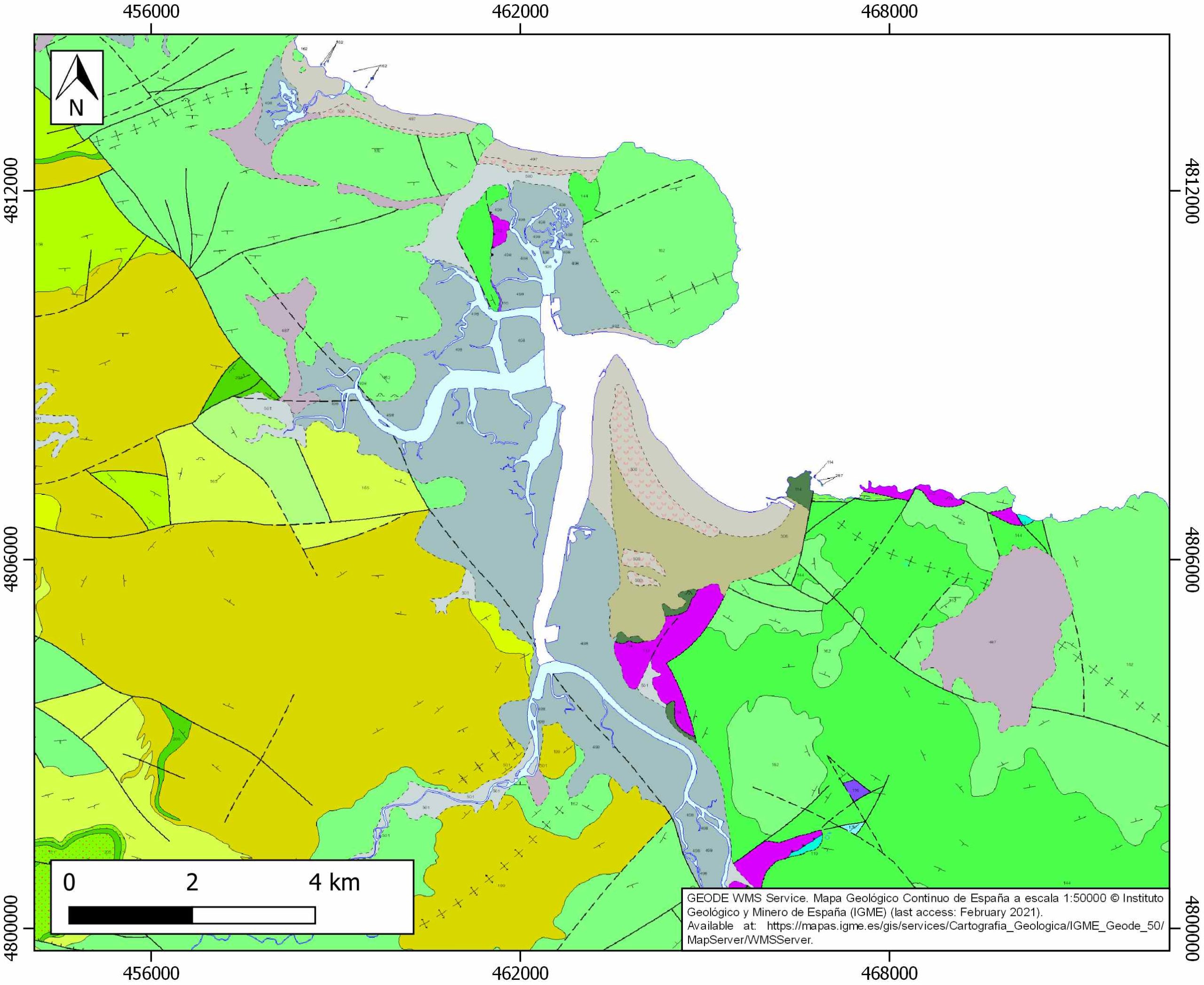
| Section source | IGME MAGNA 50. SHEET 36 (CASTRO-URDIALES) |
| Well / Borehole availability #1 | n.a. |
| Well / Borehole availability #2 | n.a. |
| Available data (Stratigraphy) #1 | López-Horgue, M. A., Iriarte, E., Schröder, S., Fernández-Mendiola, P. A., Caline, B., Corneyllie, H., Frémont, J., Sudrie, M., Zerti, S., 2010. Structurally controlled hydrothermal dolomites in Albian carbonates of the Asón valley, Basque Cantabrian Basin, Northern Spain. Marine and Petroleum Geology, 27(5), 1069-1092. [link] |
| Available data (Stratigraphy) #2 | López-Horgue, M. A., Owen, H. G., Aranburu, A., Fernández-Mendiola, P. A., García-Mondéjar, J., 2009. Early late Albian (Cretaceous) of the central region of the Basque-Cantabrian Basin, northern Spain: biostratigraphy based on ammonites and orbitolinids. Cretaceous Research, 30(2), 385-400. [link] |
| Available data (Stratigraphy) #3 | Iriarte, E., Lopez-Horgue, M. A., Schroeder, S., Caline, B., 2012. Interplay between fracturing and hydrothermal fluid flow in the Asón Valley hydrothermal dolomites (Basque–Cantabrian Basin, Spain). Geological Society, London, Special Publications, 370(1), 207-227. [link] |
| Available data (Stratigraphy) #4 | Badillo, J. M., 1982. Estudio geológico del sector de Ramales de la Victoria (Prov. de Santander). Kobie, 12, 139-166. [link] |
| Available data (Stratigraphy) #5 | Pedrera, A., García‐Senz, J., Ayala, C., Ruiz‐Constán, A., Rodríguez‐Fernández, L. R., Robador, A., González Menéndez, L., 2017. Reconstruction of the exhumed mantle across the North Iberian Margin by crustal‐scale 3‐D gravity inversion and geological cross section. Tectonics, 36, 3155-3177. [link] |
| Available data (Stratigraphy) #6 | Cámara, P., 2017. Salt and Strike-Slip Tectonics as Main Drivers in the Structural Evolution of the Basque-Cantabrian Basin, Spain. In Permo-Triassic Salt Provinces of Europe, North Africa and the Atlantic Margins (pp. 371-393). Elsevier. [link] |
| Regional Stratigraphy | Pedrera, A., García‐Senz, J., Ayala, C., Ruiz‐Constán, A., Rodríguez‐Fernández, L. R., Robador, A., González Menéndez, L., 2017. Reconstruction of the exhumed mantle across the North Iberian Margin by crustal‐scale 3‐D gravity inversion and geological cross section. Tectonics, 36, 3155-3177. [link] |
| Seismic data availability #1 | n.a. |
| Seismic data availability #2 | n.a. |
| Seismic data availability #3 | n.a. |
| Available data (Structure) #1 | López-Horgue, M. A., Iriarte, E., Schröder, S., Fernández-Mendiola, P. A., Caline, B., Corneyllie, H., Frémont, J., Sudrie, M., Zerti, S., 2010. Structurally controlled hydrothermal dolomites in Albian carbonates of the Asón valley, Basque Cantabrian Basin, Northern Spain. Marine and Petroleum Geology, 27(5), 1069-1092. [link] |
| Available data (Structure) #2 | Gómez, M., Vergés, J., Riaza, C., 2002. Inversion tectonics of the northern margin of the Basque Cantabrian Basin. Bulletin de la Société géologique de France, 173(5), 449-459. [link] |
| Available data (Structure) #3 | Pedrera, A., García‐Senz, J., Ayala, C., Ruiz‐Constán, A., Rodríguez‐Fernández, L. R., Robador, A., González Menéndez, L., 2017. Reconstruction of the exhumed mantle across the North Iberian Margin by crustal‐scale 3‐D gravity inversion and geological cross section. Tectonics, 36, 3155-3177. [link] |
| Available data (Structure) #4 | Cámara, P., 2017. Salt and Strike-Slip Tectonics as Main Drivers in the Structural Evolution of the Basque-Cantabrian Basin, Spain. In Permo-Triassic Salt Provinces of Europe, North Africa and the Atlantic Margins (pp. 371-393). Elsevier. [link] |
| Available data (Structure) #5 | Pedrera, A., García‐Senz, J., Ayala, C., Ruiz‐Constán, A., Rodríguez‐Fernández, L. R., Robador, A., González Menéndez, L., 2017. Reconstruction of the exhumed mantle across the North Iberian Margin by crustal‐scale 3‐D gravity inversion and geological cross section. Tectonics, 36, 3155-3177. [link] |
| Available data (Structure) #6 | n.a. |
| Available data (Analogue modelling) #1 | n.a. |
| Available data (Analogue modelling) #2 | n.a. |
| Available data (Analogue modelling) #3 | n.a. |
| Available data (Gravimetry – Tomography) #1 | Pedrera, A., García‐Senz, J., Ayala, C., Ruiz‐Constán, A., Rodríguez‐Fernández, L. R., Robador, A., González Menéndez, L., 2017. Reconstruction of the exhumed mantle across the North Iberian Margin by crustal‐scale 3‐D gravity inversion and geological cross section. Tectonics, 36, 3155-3177. [link] |
| Available data (Gravimetry – Tomography) #2 | Ayala, C., Bohoyo, F., Maestro, A., Reguera, M. I., Torne, M., Rubio, F., Fernández, M., García-Lobón, J. L., 2016. Updated Bouguer anomalies of the Iberian Peninsula: a new perspective to interpret the regional geology. Journal of Maps, 12(5), 1089-1092. [link] |
| Available data (Gravimetry – Tomography) #3 | n.a. |
| Available data (Geochemistry) #1 | Ortí, F., García-Veigas, J., Rossell, L., Jurado, M. J., Utrilla, R., 1996. Formaciones salinas de las cuencas triásicas en la Península Ibérica: Caracterización Petrológica y Geoquímica. Cuadernos de Geología Ibérica, 20, 13-35. [link] |
| Available data (Geochemistry) #2 | Iribar, V., Ábalos, B., 2011. The geochemical and isotopic record of evaporite recycling in spas and salterns of the Basque Cantabrian basin, Spain. Applied geochemistry, 26(8), 1315-1329. [link] |
| Available data (Geochemistry) #3 | Béziat, D., Joron, J.L., Monchoux, P., Treuil, M., Walgenwitz, F., 1991. Geodynamic implications of geochemical data for the Pyrenean ophites (Spain-France). Chemical Geology, 89, 243-262. [link] |
| Available data (Geochemistry) #4 | n.a. |
| Available data (Petrophysics) #1 | Llamas, B., Castañeda, M. C., Laín, C., Pous, J., 2017. Study of the Basque–Cantabrian basin as a suitable region for the implementation of an energy storage system based on compressed air energy storage (CAES). Environmental Earth Sciences, 76(5), 204. [link] |
| Available data (Petrophysics) #2 | n.a. |
| IGME Geological Map (MAGNA50) Sheet number | 36-Castro-Urdiales. [link] |
| Other Maps #1 (source) | Perona, J., 2016. Mineralizaciones de Pb-Zn asociadas a los diapiros de Murguía y Orduña (Cuenca Vasco-Cantábrica) [PhD thesis]: Barcelona, Universitat de Barcelona, 281 pp. [link] |
| Other Maps #2 (source) | Iriarte, E., Lopez-Horgue, M. A., Schroeder, S., Caline, B., 2012. Interplay between fracturing and hydrothermal fluid flow in the Asón Valley hydrothermal dolomites (Basque–Cantabrian Basin, Spain). Geological Society, London, Special Publications, 370(1), 207-227. [link] |
| Other related references #1 | Pujalte, V., 1982. La evolución paleogeográfica de la cuenca ‘Wealdense’de Cantabria. Cuadernos de Geología Ibérica, 8, 65-83. [link] |
| Other related references #2 | Cadenas, P., Manatschal, G., Fernández-Viejo, G., 2020. Unravelling the architecture and evolution of the inverted multi-stage North Iberian-Bay of Biscay rift. Gondwana Research, 88, 67-87. [link] |
| Other related references #3 | López-Horgue, M. A., 2000. El Aptiense-Albiense de Karrantza-Lanestona (Bizkaia y Cantabria) [Ph.D. thesis]: Universidad del Paıs Vasco/Euskal Herriko Unibertsitatea. Unpublished, 264pp. [link] |
| Other related references #4 | García‐Mondéjar, J., López‐Horgue, M. A., Aranburu, A., Fernández‐Mendiola, P. A., 2005. Pulsating subsidence during a rift episode: stratigraphic and tectonic consequences (Aptian–Albian, northern Spain). Terra Nova, 17(6), 517-525. [link] |
Well and Seismic Data
| UNIQUE_ID | 111 |
| Seismic survey name #1 | 7B3-STC84 |
| Across structure? #1 | Y |
| Seismic profile ID (IGME) #1 | 9098 |
| Seismic profile code #1 | 13670 |
| Seismic profile name #1 | STC2 |
| Seismic survey year #1 | 1981 |
| Data repository #1 | SIGEOF Data Catalogue (Section available under request). ©Instituto Geológico y Minero de España (IGME). https://info.igme.es/SIGEOF/ |
| Length (km) #1 | 21.82 |
| Seismic survey name #2 | 0000A00G |
| Across structure? #2 | Y |
| Seismic profile ID (IGME) #2 | 241 |
| Seismic profile code #2 | 1090 |
| Seismic profile name #2 | Unknown |
| Seismic survey year #2 | |
| Data repository #2 | SIGEOF Data Catalogue (Private access section). ©Instituto Geológico y Minero de España (IGME). https://info.igme.es/SIGEOF/ |
| Length (km) #2 | 6.21 |
| Seismic survey name #3 | 0000A00G |
| Across structure? #3 | Y |
| Seismic profile ID (IGME) #3 | 242 |
| Seismic profile code #3 | 1091 |
| Seismic profile name #3 | Unknown |
| Seismic survey year #3 | |
| Data repository #3 | SIGEOF Data Catalogue (Private access section). ©Instituto Geológico y Minero de España (IGME). https://info.igme.es/SIGEOF/ |
| Length (km) #3 | 6.29 |
| Seismic survey name #4 | 7B3-STC84 |
| Across structure? #4 | N (within 3km) |
| Seismic profile ID (IGME) #4 | 9088 |
| Seismic profile code #4 | 13660 |
| Seismic profile name #4 | STC84-16 |
| Seismic survey year #4 | 1984 |
| Data repository #4 | SIGEOF Data Catalogue (Section available under request). ©Instituto Geológico y Minero de España (IGME). https://info.igme.es/SIGEOF/ |
| Length (km) #4 | 21.93 |
| Seismic survey name #5 | 7B3-STC84 |
| Across structure? #5 | N (within 3km) |
| Seismic profile ID (IGME) #5 | 9092 |
| Seismic profile code #5 | 13664 |
| Seismic profile name #5 | STC84-11 |
| Seismic survey year #5 | 1984 |
| Data repository #5 | SIGEOF Data Catalogue (Section available under request). ©Instituto Geológico y Minero de España (IGME). https://info.igme.es/SIGEOF/ |
| Length (km) #5 | 21.62 |
| Seismic survey name #6 | 7B3-STC84 |
| Across structure? #6 | N (within 3km) |
| Seismic profile ID (IGME) #6 | 9098 |
| Seismic profile code #6 | 13670 |
| Seismic profile name #6 | STC2 |
| Seismic survey year #6 | 1981 |
| Data repository #6 | SIGEOF Data Catalogue (Section available under request). ©Instituto Geológico y Minero de España (IGME). https://info.igme.es/SIGEOF/ |
| Length (km) #6 | 21.82 |
| Seismic survey name #7 | 7B3-STC4 |
| Across structure? #7 | N (within 3km) |
| Seismic profile ID (IGME) #7 | 9085 |
| Seismic profile code #7 | 13657 |
| Seismic profile name #7 | STC4 |
| Seismic survey year #7 | 1981 |
| Data repository #7 | SIGEOF Data Catalogue (Section available under request). ©Instituto Geológico y Minero de España (IGME). https://info.igme.es/SIGEOF/ |
| Length (km) #7 | 23.79 |
| Seismic survey name #8 | 7B2-STC |
| Across structure? #8 | N (within 3km) |
| Seismic profile ID (IGME) #8 | 9061 |
| Seismic profile code #8 | 13633 |
| Seismic profile name #8 | STC19 |
| Seismic survey year #8 | 1981 |
| Data repository #8 | SIGEOF Data Catalogue (Section available under request). ©Instituto Geológico y Minero de España (IGME). https://info.igme.es/SIGEOF/ |
| Length (km) #8 | 17.23 |
| Seismic survey name #9 | |
| Across structure? #9 | |
| Seismic profile ID (IGME) #9 | |
| Seismic profile code #9 | |
| Seismic profile name #9 | |
| Seismic survey year #9 | |
| Data repository #9 | |
| Length (km) #9 | |
| Seismic survey name #10 | |
| Across structure? #10 | |
| Seismic profile ID (IGME) #10 | |
| Seismic profile code #10 | |
| Seismic profile name #10 | |
| Seismic survey year #10 | |
| Data repository #10 | |
| Length (km) #10 | |
| Seismic survey name #11 | |
| Across structure? #11 | |
| Seismic profile ID (IGME) #11 | |
| Seismic profile code #11 | |
| Seismic profile name #11 | |
| Seismic survey year #11 | |
| Data repository #11 | |
| Length (km) #11 | |
| Seismic survey name #12 | |
| Across structure? #12 | |
| Seismic profile ID (IGME) #12 | |
| Seismic profile code #12 | |
| Seismic profile name #12 | |
| Seismic survey year #12 | |
| Data repository #12 | |
| Length (km) #12 | |
| Seismic survey name #13 | |
| Across structure? #13 | |
| Seismic profile ID (IGME) #13 | |
| Seismic profile code #13 | |
| Seismic profile name #13 | |
| Seismic survey year #13 | |
| Data repository #13 | |
| Length (km) #13 | |
| Seismic survey name #14 | |
| Across structure? #14 | |
| Seismic profile ID (IGME) #14 | |
| Seismic profile code #14 | |
| Seismic profile name #14 | |
| Seismic survey year #14 | |
| Data repository #14 | |
| Length (km) #14 | |
| Seismic survey name #15 | |
| Across structure? #15 | |
| Seismic profile ID (IGME) #15 | |
| Seismic profile code #15 | |
| Seismic profile name #15 | |
| Seismic survey year #15 | |
| Data repository #15 | |
| Length (km) #15 | |
| Seismic survey name #16 | |
| Across structure? #16 | |
| Seismic profile ID (IGME) #16 | |
| Seismic profile code #16 | |
| Seismic profile name #16 | |
| Seismic survey year #16 | |
| Data repository #16 | |
| Length (km) #16 | |
| Seismic survey name #17 | |
| Across structure? #17 | |
| Seismic profile ID (IGME) #17 | |
| Seismic profile code #17 | |
| Seismic profile name #17 | |
| Seismic survey year #17 | |
| Data repository #17 | |
| Length (km) #17 | |
| Seismic survey name #18 | |
| Across structure? #18 | |
| Seismic profile ID (IGME) #18 | |
| Seismic profile code #18 | |
| Seismic profile name #18 | |
| Seismic survey year #18 | |
| Data repository #18 | |
| Length (km) #18 | |
| Seismic survey name #19 | |
| Across structure? #19 | |
| Seismic profile ID (IGME) #19 | |
| Seismic profile code #19 | |
| Seismic profile name #19 | |
| Seismic survey year #19 | |
| Data repository #19 | |
| Length (km) #19 | |
| Seismic survey name #20 | |
| Across structure? #20 | |
| Seismic profile ID (IGME) #20 | |
| Seismic profile code #20 | |
| Seismic profile name #20 | |
| Seismic survey year #20 | |
| Data repository #20 | |
| Length (km) #20 | |
| Seismic survey name #21 | |
| Across structure? #21 | |
| Seismic profile ID (IGME) #21 | |
| Seismic profile code #21 | |
| Seismic profile name #21 | |
| Seismic survey year #21 | |
| Data repository #21 | |
| Length (km) #21 | |
| Borehole name #1 | AJO-5B |
| Company #1 | OUTOKUMPU |
| Traget #1 | BASE METALS |
| Across structure? #1 | N (within 5 km) |
| Borehole name #2 | AJO-5 |
| Company #2 | OUTOKUMPU |
| Traget #2 | BASE METALS |
| Across structure? #2 | N (within 5 km) |
| Borehole name #3 | |
| Company #3 | |
| Traget #3 | |
| Across structure? #3 | |
| Borehole name #4 | |
| Company #4 | |
| Traget #4 | |
| Across structure? #4 | |
| Borehole name #5 | |
| Company #5 | |
| Traget #5 | |
| Across structure? #5 | |
| Borehole name #6 | |
| Company #6 | |
| Traget #6 | |
| Across structure? #6 | |
| Borehole name #7 | |
| Company #7 | |
| Traget #7 | |
| Across structure? #7 | |
| Borehole name #8 | |
| Company #8 | |
| Traget #8 | |
| Across structure? #8 | |
| Borehole name #9 | |
| Company #9 | |
| Traget #9 | |
| Across structure? #9 | |
| Borehole name #10 | |
| Company #10 | |
| Traget #10 | |
| Across structure? #10 | |
| Borehole name #11 | |
| Company #11 | |
| Traget #11 | |
| Across structure? #11 | |
| Borehole name #12 | |
| Company #12 | |
| Traget #12 | |
| Across structure? #12 | |
| Borehole name #13 | |
| Company #13 | |
| Traget #13 | |
| Across structure? #13 | |
| Borehole name #14 | |
| Company #14 | |
| Traget #14 | |
| Across structure? #14 | |
| Borehole name #15 | |
| Company #15 | |
| Traget #15 | |
| Across structure? #15 |
Geographical Data (EPSG:4326 - WGS 84)
| UNIQUE_ID | 111 |
| X Centroid (Structure shape) | -3.457805 |
| Y Centroid (Structure shape) | -3.457805 |
| Xmin (Structure shape) | -3.515550 |
| Xmax (Structure shape) | -3.413983 |
| Ymin (Structure shape) | 43.374406 |
| Ymax (Structure shape) | 43.465901 |
| Xmin seismic line #1 | -3.742308 |
| Xmax seismic line #1 | -3.474013 |
| Ymin seismic line #1 | 43.446876 |
| Ymax seismic line #1 | 43.453691 |
| Xmin seismic line #2 | -3.454043 |
| Xmax seismic line #2 | -3.411374 |
| Ymin seismic line #2 | 43.400803 |
| Ymax seismic line #2 | 43.442111 |
| Xmin seismic line #3 | -3.504851 |
| Xmax seismic line #3 | -3.454043 |
| Ymin seismic line #3 | 43.442111 |
| Ymax seismic line #3 | 43.482863 |
| Xmin seismic line #4 | -3.780938 |
| Xmax seismic line #4 | -3.511197 |
| Ymin seismic line #4 | 43.404253 |
| Ymax seismic line #4 | 43.417104 |
| Xmin seismic line #5 | -3.779088 |
| Xmax seismic line #5 | -3.512766 |
| Ymin seismic line #5 | 43.425706 |
| Ymax seismic line #5 | 43.434875 |
| Xmin seismic line #6 | -3.742308 |
| Xmax seismic line #6 | -3.474013 |
| Ymin seismic line #6 | 43.446876 |
| Ymax seismic line #6 | 43.453691 |
| Xmin seismic line #7 | -3.764553 |
| Xmax seismic line #7 | -3.475085 |
| Ymin seismic line #7 | 43.379730 |
| Ymax seismic line #7 | 43.391190 |
| Xmin seismic line #8 | -3.528583 |
| Xmax seismic line #8 | -3.506053 |
| Ymin seismic line #8 | 43.331862 |
| Ymax seismic line #8 | 43.485974 |
| Xmin seismic line #9 | |
| Xmax seismic line #9 | |
| Ymin seismic line #9 | |
| Ymax seismic line #9 | |
| Xmin seismic line #10 | |
| Xmax seismic line #10 | |
| Ymin seismic line #10 | |
| Ymax seismic line #10 | |
| Xmin seismic line #11 | |
| Xmax seismic line #11 | |
| Ymin seismic line #11 | |
| Ymax seismic line #11 | |
| Xmin seismic line #12 | |
| Xmax seismic line #12 | |
| Ymin seismic line #12 | |
| Ymax seismic line #12 | |
| Xmin seismic line #13 | |
| Xmax seismic line #13 | |
| Ymin seismic line #13 | |
| Ymax seismic line #13 | |
| Xmin seismic line #14 | |
| Xmax seismic line #14 | |
| Ymin seismic line #14 | |
| Ymax seismic line #14 | |
| Xmin seismic line #15 | |
| Xmax seismic line #15 | |
| Ymin seismic line #15 | |
| Ymax seismic line #15 | |
| Xmin seismic line #16 | |
| Xmax seismic line #16 | |
| Ymin seismic line #16 | |
| Ymax seismic line #16 | |
| Xmin seismic line #17 | |
| Xmax seismic line #17 | |
| Ymin seismic line #17 | |
| Ymax seismic line #17 | |
| Xmin seismic line #18 | |
| Xmax seismic line #18 | |
| Ymin seismic line #18 | |
| Ymax seismic line #18 | |
| Xmin seismic line #19 | |
| Xmax seismic line #19 | |
| Ymin seismic line #19 | |
| Ymax seismic line #19 | |
| Xmin seismic line #20 | |
| Xmax seismic line #20 | |
| Ymin seismic line #20 | |
| Ymax seismic line #20 | |
| Xmin seismic line #21 | |
| Xmax seismic line #21 | |
| Ymin seismic line #21 | |
| Ymax seismic line #21 | |
| X borehole #1 | -3.502268 |
| Y borehole #1 | 43.456069 |
| X borehole #2 | -3.502268 |
| Y borehole #2 | 43.456069 |
| X borehole #3 | |
| Y borehole #3 | |
| X borehole #4 | |
| Y borehole #4 | |
| X borehole #5 | |
| Y borehole #5 | |
| X borehole #6 | |
| Y borehole #6 | |
| X borehole #7 | |
| Y borehole #7 | |
| X borehole #8 | |
| Y borehole #8 | |
| X borehole #9 | |
| Y borehole #9 | |
| X borehole #10 | |
| Y borehole #10 | |
| X borehole #11 | |
| Y borehole #11 | |
| X borehole #12 | |
| Y borehole #12 | |
| X borehole #13 | |
| Y borehole #13 | |
| X borehole #14 | |
| Y borehole #14 | |
| X borehole #15 | |
| Y borehole #15 |

