General Information
| Structure type | Evaporite-cored anticline |
| Deformed/Undeformed | Deformed |
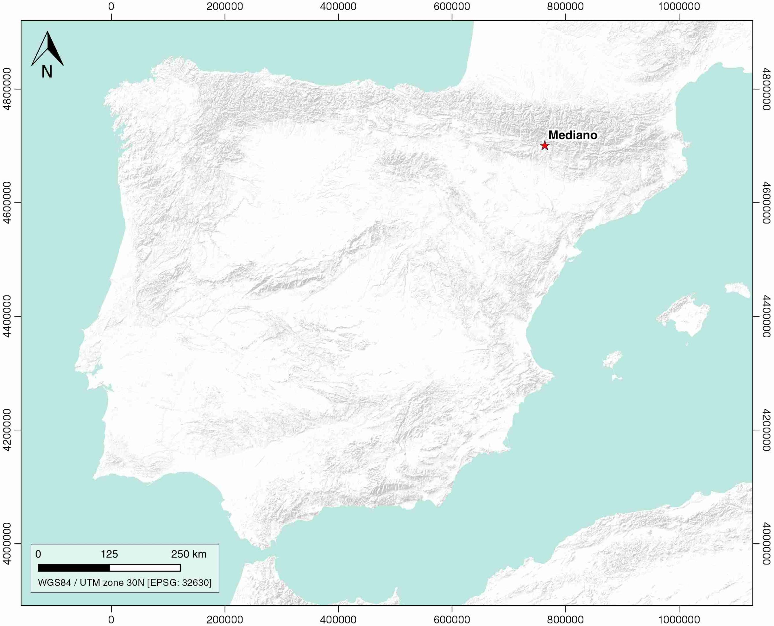
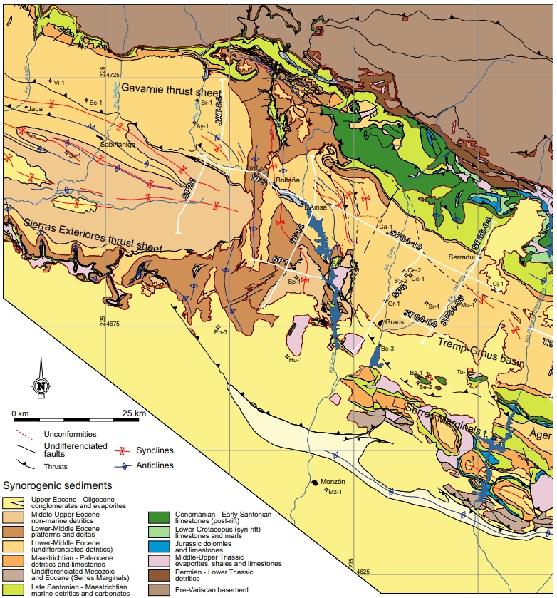
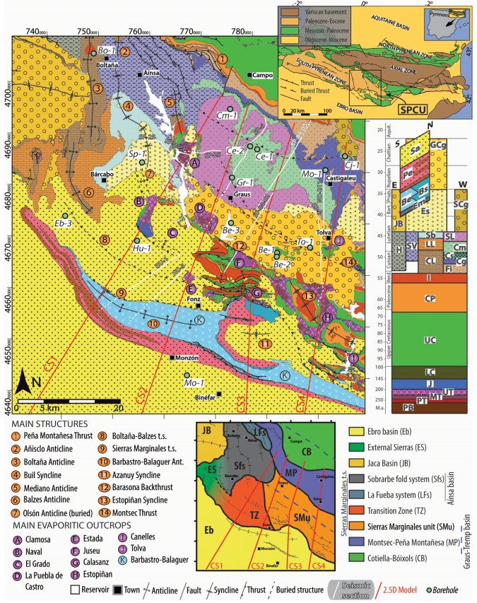
| Geological Setting | South Pyrenees Central Unit (Sierras Marginales; Gavarnie thrust sheet), Southern Pyrenees |
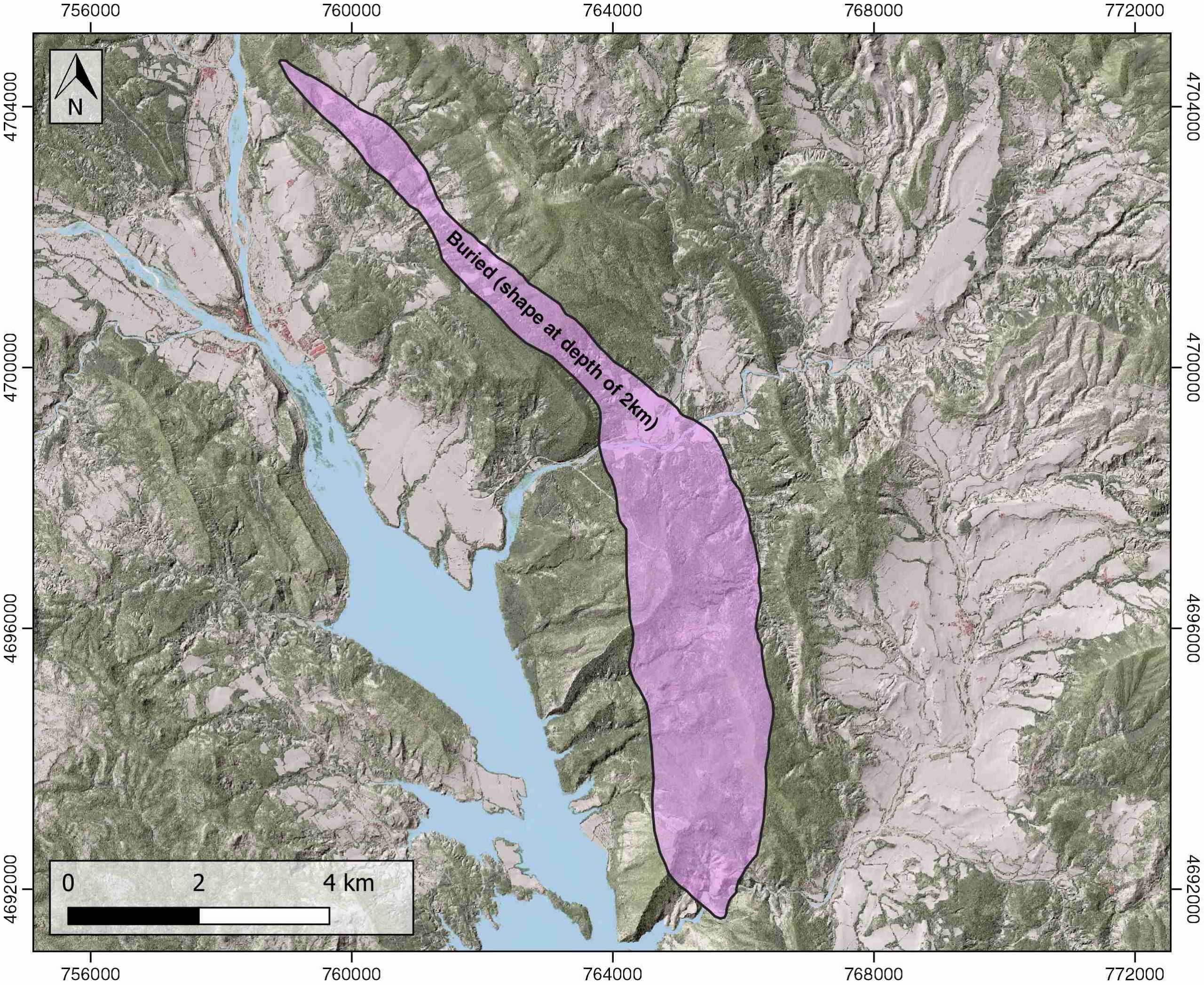
| Outcropping/buried | Buried |
| Evaporite unit/s name | El Pont de Suert Fm. |
| Evaporite unit/s age | Upper Anisian and Carnian-Rhaetian (Middle-Upper Triassic) |
| Evaporite unit/s origin | Marine |
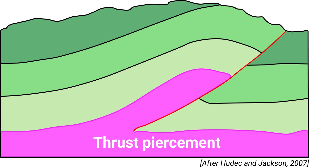
| Classif. (Hudec and Jackson, 2009) | Ductile piercement, Thrust piercement |
| Classif. (Jackson and Talbot, 1986) | Salt anticline |
| Age of evaporite flow or deformation (when deformed) | Eocene |
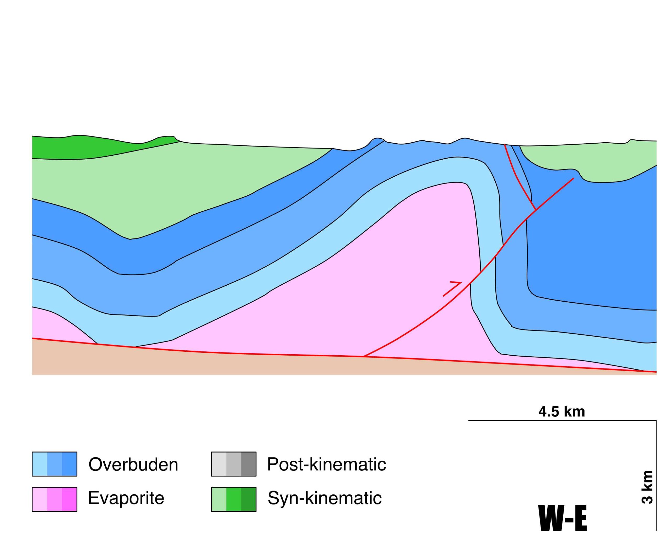
| Other comments | The great thickness of the Triassic section in the anticline core is interpreted as the result of intra-Triassic duplexes and superposition of several detachment levels (see Cámara and Flinch, 2017). |
Generic Data
| Unique ID | 66 |
| Name | Mediano |
| Structure type | Evaporite-cored anticline |
| Deformed/Undeformed | Deformed |
| Buried/Outcropping | Outcropping |
| Geological setting | Southern Pyrenees |
| Geological Regional Setting | South Pyrenees Central Unit (Sierras Marginales; Gavarnie thrust sheet) |
| Evaporite unit/s name | El Pont de Suert Fm. (Middle Muschelkalk and Keuper Facies) |
| Evaporite unit/s age | Upper Anisian and Carnian-Rhaetian (Middle-Upper Triassic) |
| Evaporite unit/s era | Mesozoic |
| Evaporite unit/s origin | Marine |
| Evaporite unit/s composition | Shale-Marlstone-Gypsum-Anhydrite |
| Post-kinematic unit/s (or post-evaporite units when evaporites are undeformed) | Priabonian-Oligocene (Campodarbe Fm., sandstones and claystones) ; Oligocene (Graus Fm., conglomerates) ; Quaternary (alluvial and colluvial detrital deposits) |
| Post-kinematic unit/s age (or post-evaporite units when evaporites are undeformed) | Priabonian-Holocene |
| Classification (Hudec and Jackson, 2009) | Thrust piercement / Ductile piercement |
| Classification (Jackson and Talbot, 1986) | Salt anticline |
| Mining activity? | Y |
| Mining activity start | – |
| Mining activity end | – |
| Mining galleries? | – |
| Mining products | Sandstone |
| Mining sub-products | – |
| Evaporite flow? | Y |
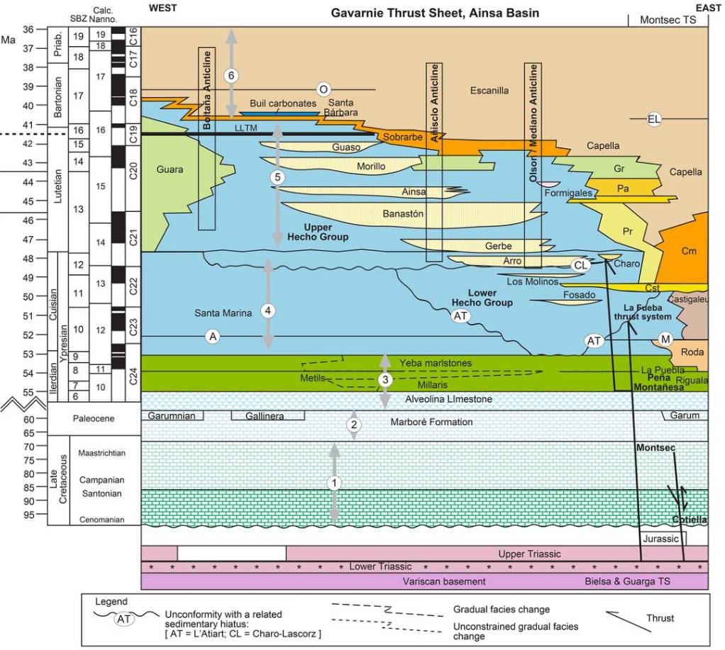
| Age of evaporite flow | Lutetian-Bartonian |
| Flow or deformation triggering mechanisms | Clockwise rotation of the structures as a consequence of the differential and larger southern displacement of the South Pyrenean thrust sheets located further to the east where the Triassic evaporitic section was thicker (see Cámara & Klimowitz, 1985; Mochales et al., 2012) |
| Flow-linked structures? | Y |
| Halokinetic structures | Thrust faults / thickness variations / joints / progressive unconformities |
| Post-evaporite and pre-kinematic unit/s (overbuden) | Upper Cenomanian-Lower Santonian («Calcaires des Canyons», limestones) ; Upper Santonian-Maastrichtian (limestones and calcarenites) ; Palaeocene (Garumnian, shales, mudstones, limestones) ; Illerdian (Alveolinid Limestone) ; Lower Eocene ((illaris, Metils, and Yeba Fms., marlstones and limestones) |
| Syn-kinematic unit/s | Early-Middle Lutetian (San Vicente Fm., shales, marlstones, sandstones, brecchias) ; Middle-Late Lutetian (Sobrarbe Fm., mudstones, shales and sandstones ) ; Late Lutetian-Bartonian (Escanilla Fm., sandstones and conglomerates) |
| Available seismic profiles | JAT-88 / SP-67 / ND-115 / SP-65 / JAT-98 / SP-68 / JAT-86 / ND-163 / SP-67 / SP-3 / SP-14 / JAT-88 / JAT-90 / JAT-86 / SP-84-18 / SP-84-17 / SP-84-23 / JAT-98 / SP-68 / SP-19 / SP-84-10 |
| Available boreholes | Surpirineica-1 / Campanue-1 |
| Additional comments | The great thickness of the Triassic section in the anticline core is interpreted as the result of intra-Triassic duplexes and superposition of several detachment levels (see Cámara and Flinch, 2017). |
Mining Data
| UNIQUE_ID | 66 |
| Minning exploitations within <2km? | Y |
| Historical/Active | Active |
| Exploitation name #1 | AINSA |
| Exploitation ID (Spanish National Mining Cadastre) #1 | 186 |
| Municipality #1 | Aínsa-Sobrarbe |
| Province #1 | HUESCA |
| Company #1 | EXCAVACIONES ACB SL |
| Main minning Products #1 | Sandstone |
| Exploitation name #2 | |
| Exploitation ID (Spanish National Mining Cadastre) #2 | |
| Municipality #2 | |
| Province #2 | |
| Company #2 | |
| Main minning Products #2 | |
| Exploitation name #3 | |
| Exploitation ID (Spanish National Mining Cadastre) #3 | |
| Municipality #3 | |
| Province #3 | |
| Company #3 | |
| Main minning Products #3 |
Quantitative Data
| UNIQUE_ID | 66 |
| Outcropping area (km2) | 17.80004 |
| Horizontal intersection area (km2) (when buried) | Not buried |
| Depth of intersection area (km2) (when buried) | Not buried |
| Max. Width (Km) | 14.8031398 |
| Max. Length (Km) | 3.6072143 |
| Max. Evaporites thickness (km) | 3.5 |
| Max. Deformation age (Ma) | 47 |
| Min. Deformation age (Ma) | 37 |
| Deformation stages | 1 |
Reference Data
| UNIQUE_ID | 66 |
| Section source | Muñoz, J. A., Beamud, E., Fernández, O., Arbués, P., Dinarès‐Turell, J., Poblet, J., 2013. The Ainsa Fold and thrust oblique zone of the central Pyrenees: Kinematics of a curved contractional system from paleomagnetic and structural data. Tectonics, 32(5), 1142-1175. [link] |
| Well / Borehole availability #1 | Cámara, P., Flinch, J. F., 2017. The southern Pyrenees: a salt-based fold-and-thrust belt. In Permo-Triassic Salt Provinces of Europe, North Africa and the Atlantic Margins (pp. 395-415). Elsevier. [link] |
| Well / Borehole availability #2 | Muñoz, J. A., Mencos, J., Roca, E., Carrera, N., Gratacós, O., Ferrer, O., Fernández, O., 2018. The structure of the South-Central-Pyrenean fold and thrust belt as constrained by subsurface data. Geologica Acta, 16(4), 439-460. [link] |
| Available data (Stratigraphy) #1 | Muñoz, J. A., Beamud, E., Fernández, O., Arbués, P., Dinarès‐Turell, J., Poblet, J., 2013. The Ainsa Fold and thrust oblique zone of the central Pyrenees: Kinematics of a curved contractional system from paleomagnetic and structural data. Tectonics, 32(5), 1142-1175. [link] |
| Available data (Stratigraphy) #2 | Bayliss, N. J., Pickering, K. T., 2015. Deep-marine structurally confined channelised sandy fans: middle eocene morillo system, Ainsa basin, Spanish pyrenees. Earth-Science Reviews, 144, 82-106. [link] |
| Available data (Stratigraphy) #3 | Holl, J. E., Anastasio, D. J., 1993. Paleomagnetically derived folding rates, southern Pyrenees, Spain. Geology, 21(3), 271-274. [link] |
| Available data (Stratigraphy) #4 | Mochales, T., 2011. Chronostratigraphy, vertical axis rotations and AMS in the Boltaña anticline (Southern Pyrenees): kinematic implications [Ph.D. thesis]: Universidad de Zaragoza, 304pp. [link] |
| Available data (Stratigraphy) #5 | Mochales, T., Barnolas, A., Pueyo, E. L., Serra-Kiel, J., Casas, A. M., Samsó, J. M., …, Sanjuán, J., 2012. Chronostratigraphy of the Boltaña anticline and the Ainsa Basin (southern Pyrenees). GSA Bulletin, 124(7-8), 1229-1250. [link] |
| Available data (Stratigraphy) #6 | Beamud, E., Garcés, M., Cabrera, L., Muñoz, J. A., Almar, Y., 2003. A new middle to late Eocene continental chronostratigraphy from NE Spain. Earth and Planetary Science Letters, 216(4), 501-514. [link] |
| Regional Stratigraphy | Cantalejo, B., Pickering, K. T., McNiocaill, C., Bown, P., Johansen, K., Grant, M., 2021. A revised age-model for the Eocene deep-marine siliciclastic systems, Aínsa Basin, Spanish Pyrenees. Journal of the Geological Society, 178(1). [link] |
| Seismic data availability #1 | Muñoz, J. A., Mencos, J., Roca, E., Carrera, N., Gratacós, O., Ferrer, O., Fernández, O., 2018. The structure of the South-Central-Pyrenean fold and thrust belt as constrained by subsurface data. Geologica Acta, 16(4), 439-460. [link] |
| Seismic data availability #2 | Santolaria, P., Casas-Sainz, A. M., Soto, R., Casas, A., 2017. Gravity modelling to assess salt tectonics in the western end of the South Pyrenean Central Unit. Journal of the Geological Society, 174(2), 269-288. [link] |
| Seismic data availability #3 | Fernández, O., Muñoz, J. A., Arbués, P., Falivene, O., 2012. 3D structure and evolution of an oblique system of relaying folds: the Ainsa basin (Spanish Pyrenees). Journal of the Geological Society, 169(5), 545-559. [link] |
| Available data (Structure) #1 | Poblet, J., Muñoz, J. A., Travé, A., Serra-Kiel, J., 1998. Quantifying the kinematics of detachment folds using three-dimensional geometry: Application to the Mediano anticline (Pyrenees, Spain). Geological Society of America Bulletin, 110(1), 111-125. [link] |
| Available data (Structure) #2 | Muñoz, J. A., Beamud, E., Fernández, O., Arbués, P., Dinarès‐Turell, J., Poblet, J., 2013. The Ainsa Fold and thrust oblique zone of the central Pyrenees: Kinematics of a curved contractional system from paleomagnetic and structural data. Tectonics, 32(5), 1142-1175. [link] |
| Available data (Structure) #3 | Santolaria, P., Casas-Sainz, A. M., Soto, R., Casas, A., 2017. Gravity modelling to assess salt tectonics in the western end of the South Pyrenean Central Unit. Journal of the Geological Society, 174(2), 269-288. [link] |
| Available data (Structure) #4 | Salvini, F., Storti, F., 2002. Three-dimensional architecture of growth strata associated to fault-bend, fault-propagation, and décollement anticlines in non-erosional environments. Sedimentary Geology, 146(1-2), 57-73. [link] |
| Available data (Structure) #5 | Muñoz, J. A., Mencos, J., Roca, E., Carrera, N., Gratacós, O., Ferrer, O., Fernández, O., 2018. The structure of the South-Central-Pyrenean fold and thrust belt as constrained by subsurface data. Geologica Acta, 16(4), 439-460. [link] |
| Available data (Structure) #6 | Cámara, P., Flinch, J. F., 2017. The southern Pyrenees: a salt-based fold-and-thrust belt. In Permo-Triassic Salt Provinces of Europe, North Africa and the Atlantic Margins (pp. 395-415). Elsevier. [link] |
| Available data (Analogue modelling) #1 | n.a. |
| Available data (Analogue modelling) #2 | n.a. |
| Available data (Analogue modelling) #3 | n.a. |
| Available data (Gravimetry – Tomography) #1 | Santolaria, P., Casas-Sainz, A. M., Soto, R., Casas, A., 2017. Gravity modelling to assess salt tectonics in the western end of the South Pyrenean Central Unit. Journal of the Geological Society, 174(2), 269-288. [link] |
| Available data (Gravimetry – Tomography) #2 | Calvín, P., Santolaria, P., Casas, A. M., Pueyo, E. L., 2018. Detachment fold vs. ramp anticline: a gravity survey in the southern Pyrenean front (External Sierras). Geological Journal, 53(1), 178-190. [link] |
| Available data (Gravimetry – Tomography) #3 | Ayala, C., Bohoyo, F., Maestro, A., Reguera, M. I., Torne, M., Rubio, F., Fernández, M., García-Lobón, J. L., 2016. Updated Bouguer anomalies of the Iberian Peninsula: a new perspective to interpret the regional geology. Journal of Maps, 12(5), 1089-1092. [link] |
| Available data (Geochemistry) #1 | Thomson, K. D., Stockli, D. F., Clark, J. D., Puigdefàbregas, C., Fildani, A., 2017. Detrital zircon (U‐Th)/(He‐Pb) double‐dating constraints on provenance and foreland basin evolution of the Ainsa Basin, south‐central Pyrenees, Spain. Tectonics, 36(7), 1352-1375. [link] |
| Available data (Geochemistry) #2 | n.a. |
| Available data (Geochemistry) #3 | n.a. |
| Available data (Geochemistry) #4 | n.a. |
| Available data (Petrophysics) #1 | Santolaria, P., Casas-Sainz, A. M., Soto, R., Casas, A., 2017. Gravity modelling to assess salt tectonics in the western end of the South Pyrenean Central Unit. Journal of the Geological Society, 174(2), 269-288. [link] |
| Available data (Petrophysics) #2 | Muñoz, J. A., Beamud, E., Fernández, O., Arbués, P., Dinarès‐Turell, J., Poblet, J., 2013. The Ainsa Fold and thrust oblique zone of the central Pyrenees: Kinematics of a curved contractional system from paleomagnetic and structural data. Tectonics, 32(5), 1142-1175. [link] |
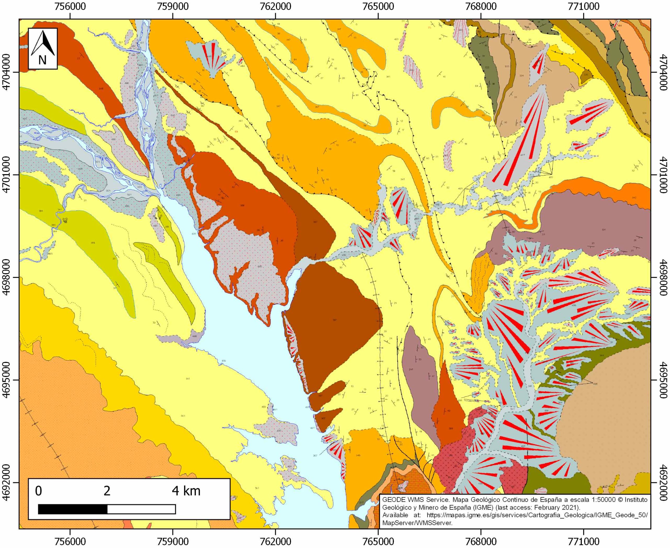
| IGME Geological Map (MAGNA50) Sheet number | 212-Campo. [link] |
| Other Maps #1 (source) | Muñoz, J. A., Mencos, J., Roca, E., Carrera, N., Gratacós, O., Ferrer, O., Fernández, O., 2018. The structure of the South-Central-Pyrenean fold and thrust belt as constrained by subsurface data. Geologica Acta, 16(4), 439-460. [link] |
| Other Maps #2 (source) | Santolaria, P., Casas-Sainz, A. M., Soto, R., Casas, A., 2017. Gravity modelling to assess salt tectonics in the western end of the South Pyrenean Central Unit. Journal of the Geological Society, 174(2), 269-288. [link] |
| Other related references #1 | Teixell, A., Barnolas, A., 1995. Significado de la discordancia de Mediano en relación con las estructuras adyacentes (Eoceno, Pirineo Central). Geogaceta, 18, 34-37. [link] |
| Other related references #2 | Poblet, J., 2020. Cartographic pattern of terminations of simple, parallel fault-bend folds, fault-propagation folds and detachment folds. Journal of Structural Geology, 138, 104135. [link] |
| Other related references #3 | Cosma, M., Finotello, A., Ielpi, A., Ventra, D., Oms, O., D’Alpaos, A., Ghinassi, M., 2020. Piracy-controlled geometry of tide-dominated point bars: Combined evidence from ancient sedimentary successions and modern channel networks. Geomorphology, 370, 107402. [link] |
| Other related references #4 | Izquierdo‐Llavall, E., Casas‐Sainz, A. M., Oliva‐Urcia, B., Villalaín, J. J., Pueyo, E., Scholger, R., 2018. Rotational kinematics of basement antiformal stacks: Paleomagnetic study of the western Nogueras Zone (Central Pyrenees). Tectonics, 37(10), 3456-3478. [link] |
Well and Seismic Data
| UNIQUE_ID | 66 |
| Seismic survey name #1 | 10C2-JAT |
| Across structure? #1 | Y |
| Seismic profile ID (IGME) #1 | 9206 |
| Seismic profile code #1 | 13778 |
| Seismic profile name #1 | JAT-88 |
| Seismic survey year #1 | 1974 |
| Data repository #1 | SIGEOF Data Catalogue (Section available under request). ©Instituto Geológico y Minero de España (IGME). https://info.igme.es/SIGEOF/ |
| Length (km) #1 | 10.65 |
| Seismic survey name #2 | 10D1-SP |
| Across structure? #2 | Y |
| Seismic profile ID (IGME) #2 | 15446 |
| Seismic profile code #2 | 20186 |
| Seismic profile name #2 | SP-67 |
| Seismic survey year #2 | 1979 |
| Data repository #2 | SIGEOF Data Catalogue (Section available under request). ©Instituto Geológico y Minero de España (IGME). https://info.igme.es/SIGEOF/ |
| Length (km) #2 | 9.69 |
| Seismic survey name #3 | 11C-ST-151 |
| Across structure? #3 | Y |
| Seismic profile ID (IGME) #3 | 14074 |
| Seismic profile code #3 | 18808 |
| Seismic profile name #3 | ND-115 |
| Seismic survey year #3 | 1963 |
| Data repository #3 | SIGEOF Data Catalogue (Private access section). ©Instituto Geológico y Minero de España (IGME). https://info.igme.es/SIGEOF/ |
| Length (km) #3 | 13.42 |
| Seismic survey name #4 | 10D1-SP |
| Across structure? #4 | Y |
| Seismic profile ID (IGME) #4 | 15448 |
| Seismic profile code #4 | 20188 |
| Seismic profile name #4 | SP-65 |
| Seismic survey year #4 | 1979 |
| Data repository #4 | SIGEOF Data Catalogue (Private access section). ©Instituto Geológico y Minero de España (IGME). https://info.igme.es/SIGEOF/ |
| Length (km) #4 | 7.45 |
| Seismic survey name #5 | 10D1-JAT |
| Across structure? #5 | Y |
| Seismic profile ID (IGME) #5 | 10089 |
| Seismic profile code #5 | 14662 |
| Seismic profile name #5 | JAT-98 |
| Seismic survey year #5 | 1974 |
| Data repository #5 | SIGEOF Data Catalogue (Section available under request). ©Instituto Geológico y Minero de España (IGME). https://info.igme.es/SIGEOF/ |
| Length (km) #5 | 12.34 |
| Seismic survey name #6 | 10C2-SP |
| Across structure? #6 | Y |
| Seismic profile ID (IGME) #6 | 9248 |
| Seismic profile code #6 | 13820 |
| Seismic profile name #6 | SP-68 |
| Seismic survey year #6 | 1974 |
| Data repository #6 | SIGEOF Data Catalogue (Section available under request). ©Instituto Geológico y Minero de España (IGME). https://info.igme.es/SIGEOF/ |
| Length (km) #6 | 8.96 |
| Seismic survey name #7 | 10D1-JAT |
| Across structure? #7 | Y |
| Seismic profile ID (IGME) #7 | 10091 |
| Seismic profile code #7 | 14664 |
| Seismic profile name #7 | JAT-86 |
| Seismic survey year #7 | 1974 |
| Data repository #7 | SIGEOF Data Catalogue (Section available under request). ©Instituto Geológico y Minero de España (IGME). https://info.igme.es/SIGEOF/ |
| Length (km) #7 | 5.97 |
| Seismic survey name #8 | 11C-ST-150 |
| Across structure? #8 | Y |
| Seismic profile ID (IGME) #8 | 14072 |
| Seismic profile code #8 | 18806 |
| Seismic profile name #8 | ND-163 |
| Seismic survey year #8 | 1964 |
| Data repository #8 | SIGEOF Data Catalogue (Private access section). ©Instituto Geológico y Minero de España (IGME). https://info.igme.es/SIGEOF/ |
| Length (km) #8 | 4.28 |
| Seismic survey name #9 | 10D1-SP |
| Across structure? #9 | N (within 3km) |
| Seismic profile ID (IGME) #9 | 15446 |
| Seismic profile code #9 | 20186 |
| Seismic profile name #9 | SP-67 |
| Seismic survey year #9 | 1979 |
| Data repository #9 | SIGEOF Data Catalogue (Section available under request). ©Instituto Geológico y Minero de España (IGME). https://info.igme.es/SIGEOF/ |
| Length (km) #9 | 9.69 |
| Seismic survey name #10 | 10C2-SP |
| Across structure? #10 | N (within 3km) |
| Seismic profile ID (IGME) #10 | 9251 |
| Seismic profile code #10 | 13823 |
| Seismic profile name #10 | SP-3 |
| Seismic survey year #10 | 1979 |
| Data repository #10 | SIGEOF Data Catalogue (Section available under request). ©Instituto Geológico y Minero de España (IGME). https://info.igme.es/SIGEOF/ |
| Length (km) #10 | 29.31 |
| Seismic survey name #11 | 10D1-SP |
| Across structure? #11 | N (within 3km) |
| Seismic profile ID (IGME) #11 | 15470 |
| Seismic profile code #11 | 20210 |
| Seismic profile name #11 | SP-14 |
| Seismic survey year #11 | 1979 |
| Data repository #11 | SIGEOF Data Catalogue (Section available under request). ©Instituto Geológico y Minero de España (IGME). https://info.igme.es/SIGEOF/ |
| Length (km) #11 | 24.80 |
| Seismic survey name #12 | 10C2-JAT |
| Across structure? #12 | N (within 3km) |
| Seismic profile ID (IGME) #12 | 9206 |
| Seismic profile code #12 | 13778 |
| Seismic profile name #12 | JAT-88 |
| Seismic survey year #12 | 1974 |
| Data repository #12 | SIGEOF Data Catalogue (Section available under request). ©Instituto Geológico y Minero de España (IGME). https://info.igme.es/SIGEOF/ |
| Length (km) #12 | 10.65 |
| Seismic survey name #13 | 10D1-JAT |
| Across structure? #13 | N (within 3km) |
| Seismic profile ID (IGME) #13 | 10090 |
| Seismic profile code #13 | 14663 |
| Seismic profile name #13 | JAT-90 |
| Seismic survey year #13 | 1974 |
| Data repository #13 | SIGEOF Data Catalogue (Section available under request). ©Instituto Geológico y Minero de España (IGME). https://info.igme.es/SIGEOF/ |
| Length (km) #13 | 27.64 |
| Seismic survey name #14 | 10D1-JAT |
| Across structure? #14 | N (within 3km) |
| Seismic profile ID (IGME) #14 | 10091 |
| Seismic profile code #14 | 14664 |
| Seismic profile name #14 | JAT-86 |
| Seismic survey year #14 | 1974 |
| Data repository #14 | SIGEOF Data Catalogue (Section available under request). ©Instituto Geológico y Minero de España (IGME). https://info.igme.es/SIGEOF/ |
| Length (km) #14 | 5.97 |
| Seismic survey name #15 | 11C2-SP-84 |
| Across structure? #15 | N (within 3km) |
| Seismic profile ID (IGME) #15 | 15407 |
| Seismic profile code #15 | 20147 |
| Seismic profile name #15 | SP-84-18 |
| Seismic survey year #15 | 1984 |
| Data repository #15 | SIGEOF Data Catalogue (Section available under request). ©Instituto Geológico y Minero de España (IGME). https://info.igme.es/SIGEOF/ |
| Length (km) #15 | 4.91 |
| Seismic survey name #16 | 11D1-QUEROL-SP-84 |
| Across structure? #16 | N (within 3km) |
| Seismic profile ID (IGME) #16 | 10224 |
| Seismic profile code #16 | 14852 |
| Seismic profile name #16 | SP-84-17 |
| Seismic survey year #16 | 1984 |
| Data repository #16 | SIGEOF Data Catalogue (Section available under request). ©Instituto Geológico y Minero de España (IGME). https://info.igme.es/SIGEOF/ |
| Length (km) #16 | 11.31 |
| Seismic survey name #17 | 11D1-QUEROL-SP-84 |
| Across structure? #17 | N (within 3km) |
| Seismic profile ID (IGME) #17 | 10220 |
| Seismic profile code #17 | 14848 |
| Seismic profile name #17 | SP-84-23 |
| Seismic survey year #17 | 1984 |
| Data repository #17 | SIGEOF Data Catalogue (Section available under request). ©Instituto Geológico y Minero de España (IGME). https://info.igme.es/SIGEOF/ |
| Length (km) #17 | 20.73 |
| Seismic survey name #18 | 10D1-JAT |
| Across structure? #18 | N (within 3km) |
| Seismic profile ID (IGME) #18 | 10089 |
| Seismic profile code #18 | 14662 |
| Seismic profile name #18 | JAT-98 |
| Seismic survey year #18 | 1974 |
| Data repository #18 | SIGEOF Data Catalogue (Section available under request). ©Instituto Geológico y Minero de España (IGME). https://info.igme.es/SIGEOF/ |
| Length (km) #18 | 12.34 |
| Seismic survey name #19 | 10C2-SP |
| Across structure? #19 | N (within 3km) |
| Seismic profile ID (IGME) #19 | 9248 |
| Seismic profile code #19 | 13820 |
| Seismic profile name #19 | SP-68 |
| Seismic survey year #19 | 1974 |
| Data repository #19 | SIGEOF Data Catalogue (Section available under request). ©Instituto Geológico y Minero de España (IGME). https://info.igme.es/SIGEOF/ |
| Length (km) #19 | 8.96 |
| Seismic survey name #20 | 10D1-SP |
| Across structure? #20 | N (within 3km) |
| Seismic profile ID (IGME) #20 | 15465 |
| Seismic profile code #20 | 20205 |
| Seismic profile name #20 | SP-19 |
| Seismic survey year #20 | 1979 |
| Data repository #20 | SIGEOF Data Catalogue (Section available under request). ©Instituto Geológico y Minero de España (IGME). https://info.igme.es/SIGEOF/ |
| Length (km) #20 | 6.24 |
| Seismic survey name #21 | 11D1-QUEROL-SP-84 |
| Across structure? #21 | N (within 3km) |
| Seismic profile ID (IGME) #21 | 10232 |
| Seismic profile code #21 | 14860 |
| Seismic profile name #21 | SP-84-10 |
| Seismic survey year #21 | 1984 |
| Data repository #21 | SIGEOF Data Catalogue (Section available under request). ©Instituto Geológico y Minero de España (IGME). https://info.igme.es/SIGEOF/ |
| Length (km) #21 | 37.57 |
| Borehole name #1 | |
| Company #1 | |
| Traget #1 | |
| Across structure? #1 | |
| Borehole name #2 | |
| Company #2 | |
| Traget #2 | |
| Across structure? #2 | |
| Borehole name #3 | |
| Company #3 | |
| Traget #3 | |
| Across structure? #3 | |
| Borehole name #4 | |
| Company #4 | |
| Traget #4 | |
| Across structure? #4 | |
| Borehole name #5 | |
| Company #5 | |
| Traget #5 | |
| Across structure? #5 | |
| Borehole name #6 | |
| Company #6 | |
| Traget #6 | |
| Across structure? #6 | |
| Borehole name #7 | |
| Company #7 | |
| Traget #7 | |
| Across structure? #7 | |
| Borehole name #8 | |
| Company #8 | |
| Traget #8 | |
| Across structure? #8 | |
| Borehole name #9 | |
| Company #9 | |
| Traget #9 | |
| Across structure? #9 | |
| Borehole name #10 | |
| Company #10 | |
| Traget #10 | |
| Across structure? #10 | |
| Borehole name #11 | |
| Company #11 | |
| Traget #11 | |
| Across structure? #11 | |
| Borehole name #12 | |
| Company #12 | |
| Traget #12 | |
| Across structure? #12 | |
| Borehole name #13 | |
| Company #13 | |
| Traget #13 | |
| Across structure? #13 | |
| Borehole name #14 | |
| Company #14 | |
| Traget #14 | |
| Across structure? #14 | |
| Borehole name #15 | |
| Company #15 | |
| Traget #15 | |
| Across structure? #15 |
Geographical Data (EPSG:4326 - WGS 84)
| UNIQUE_ID | 66 |
| X Centroid (Structure shape) | 0.212272 |
| Y Centroid (Structure shape) | 0.212272 |
| Xmin (Structure shape) | 0.148192 |
| Xmax (Structure shape) | 0.235525 |
| Ymin (Structure shape) | 42.330848 |
| Ymax (Structure shape) | 42.451510 |
| Xmin seismic line #1 | 0.147113 |
| Xmax seismic line #1 | 0.269289 |
| Ymin seismic line #1 | 42.407917 |
| Ymax seismic line #1 | 42.431517 |
| Xmin seismic line #2 | 0.107133 |
| Xmax seismic line #2 | 0.205203 |
| Ymin seismic line #2 | 42.398361 |
| Ymax seismic line #2 | 42.444532 |
| Xmin seismic line #3 | 0.160441 |
| Xmax seismic line #3 | 0.304997 |
| Ymin seismic line #3 | 42.377949 |
| Ymax seismic line #3 | 42.431011 |
| Xmin seismic line #4 | 0.186940 |
| Xmax seismic line #4 | 0.265193 |
| Ymin seismic line #4 | 42.348707 |
| Ymax seismic line #4 | 42.378872 |
| Xmin seismic line #5 | 0.217987 |
| Xmax seismic line #5 | 0.237938 |
| Ymin seismic line #5 | 42.337324 |
| Ymax seismic line #5 | 42.445665 |
| Xmin seismic line #6 | 0.156410 |
| Xmax seismic line #6 | 0.168858 |
| Ymin seismic line #6 | 42.419436 |
| Ymax seismic line #6 | 42.498425 |
| Xmin seismic line #7 | 0.208999 |
| Xmax seismic line #7 | 0.276283 |
| Ymin seismic line #7 | 42.379177 |
| Ymax seismic line #7 | 42.398948 |
| Xmin seismic line #8 | 0.146816 |
| Xmax seismic line #8 | 0.193095 |
| Ymin seismic line #8 | 42.437225 |
| Ymax seismic line #8 | 42.454187 |
| Xmin seismic line #9 | 0.107133 |
| Xmax seismic line #9 | 0.205203 |
| Ymin seismic line #9 | 42.398361 |
| Ymax seismic line #9 | 42.444532 |
| Xmin seismic line #10 | -0.121726 |
| Xmax seismic line #10 | 0.184557 |
| Ymin seismic line #10 | 42.386745 |
| Ymax seismic line #10 | 42.494882 |
| Xmin seismic line #11 | 0.051467 |
| Xmax seismic line #11 | 0.168383 |
| Ymin seismic line #11 | 42.221770 |
| Ymax seismic line #11 | 42.424361 |
| Xmin seismic line #12 | 0.147113 |
| Xmax seismic line #12 | 0.269289 |
| Ymin seismic line #12 | 42.407917 |
| Ymax seismic line #12 | 42.431517 |
| Xmin seismic line #13 | 0.165918 |
| Xmax seismic line #13 | 0.273823 |
| Ymin seismic line #13 | 42.368073 |
| Ymax seismic line #13 | 42.589810 |
| Xmin seismic line #14 | 0.208999 |
| Xmax seismic line #14 | 0.276283 |
| Ymin seismic line #14 | 42.379177 |
| Ymax seismic line #14 | 42.398948 |
| Xmin seismic line #15 | 0.241261 |
| Xmax seismic line #15 | 0.267251 |
| Ymin seismic line #15 | 42.406846 |
| Ymax seismic line #15 | 42.446583 |
| Xmin seismic line #16 | 0.263295 |
| Xmax seismic line #16 | 0.330382 |
| Ymin seismic line #16 | 42.335020 |
| Ymax seismic line #16 | 42.423783 |
| Xmin seismic line #17 | 0.236674 |
| Xmax seismic line #17 | 0.460417 |
| Ymin seismic line #17 | 42.336400 |
| Ymax seismic line #17 | 42.420654 |
| Xmin seismic line #18 | 0.217987 |
| Xmax seismic line #18 | 0.237938 |
| Ymin seismic line #18 | 42.337324 |
| Ymax seismic line #18 | 42.445665 |
| Xmin seismic line #19 | 0.156410 |
| Xmax seismic line #19 | 0.168858 |
| Ymin seismic line #19 | 42.419436 |
| Ymax seismic line #19 | 42.498425 |
| Xmin seismic line #20 | 0.120131 |
| Xmax seismic line #20 | 0.180599 |
| Ymin seismic line #20 | 42.381011 |
| Ymax seismic line #20 | 42.414687 |
| Xmin seismic line #21 | 0.213167 |
| Xmax seismic line #21 | 0.623960 |
| Ymin seismic line #21 | 42.264870 |
| Ymax seismic line #21 | 42.410366 |
| X borehole #1 | |
| Y borehole #1 | |
| X borehole #2 | |
| Y borehole #2 | |
| X borehole #3 | |
| Y borehole #3 | |
| X borehole #4 | |
| Y borehole #4 | |
| X borehole #5 | |
| Y borehole #5 | |
| X borehole #6 | |
| Y borehole #6 | |
| X borehole #7 | |
| Y borehole #7 | |
| X borehole #8 | |
| Y borehole #8 | |
| X borehole #9 | |
| Y borehole #9 | |
| X borehole #10 | |
| Y borehole #10 | |
| X borehole #11 | |
| Y borehole #11 | |
| X borehole #12 | |
| Y borehole #12 | |
| X borehole #13 | |
| Y borehole #13 | |
| X borehole #14 | |
| Y borehole #14 | |
| X borehole #15 | |
| Y borehole #15 |

