General Information
| Structure type | Evaporite-cored anticline |
| Deformed/Undeformed | Deformed |
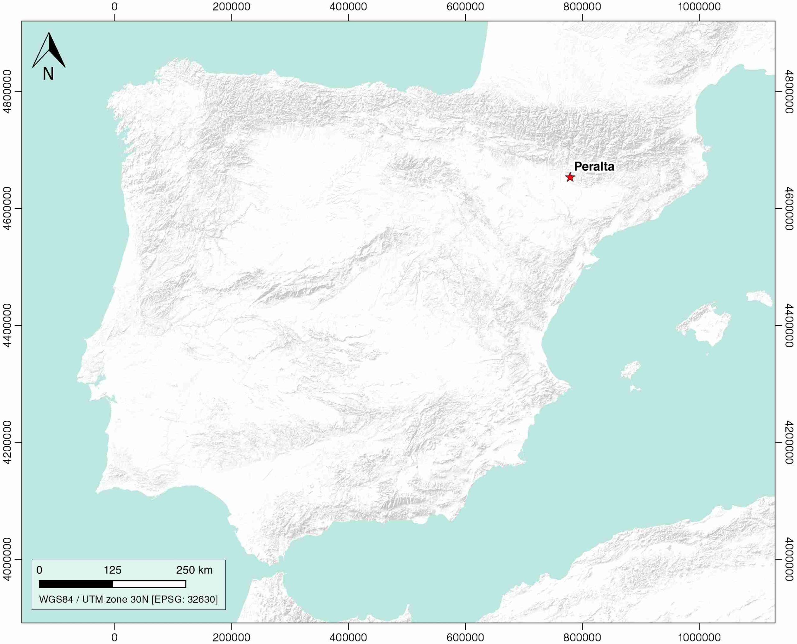
| Geological Setting | Ebro foreland basin, Northern-Central Domain |
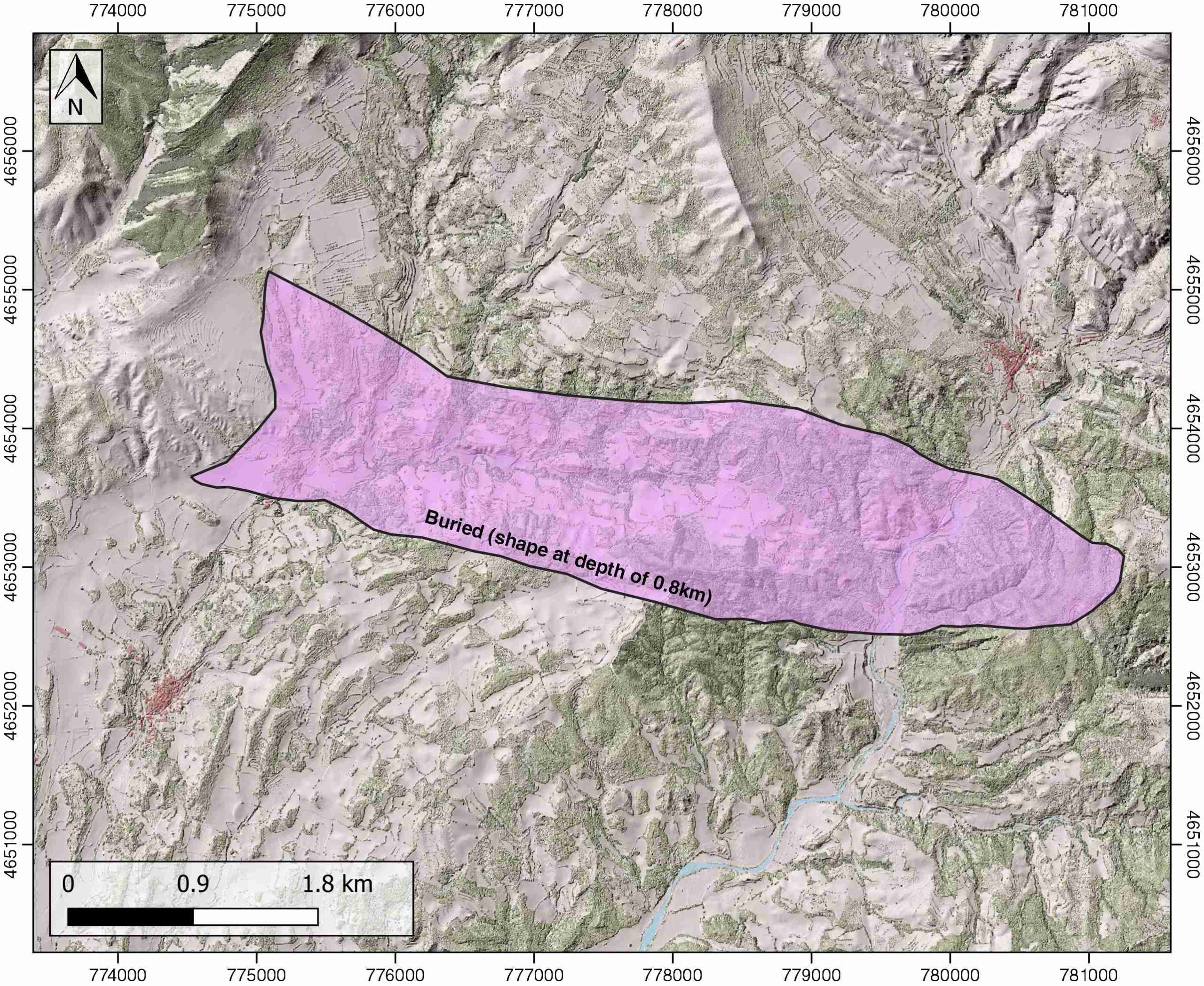
| Outcropping/buried | Buried |
| Evaporite unit/s name | Barbastro Fm., Keuper facies |
| Evaporite unit/s age | Upper Priabonian-Chattian (Eocene-Oligocene) |
| Evaporite unit/s origin | Continental |
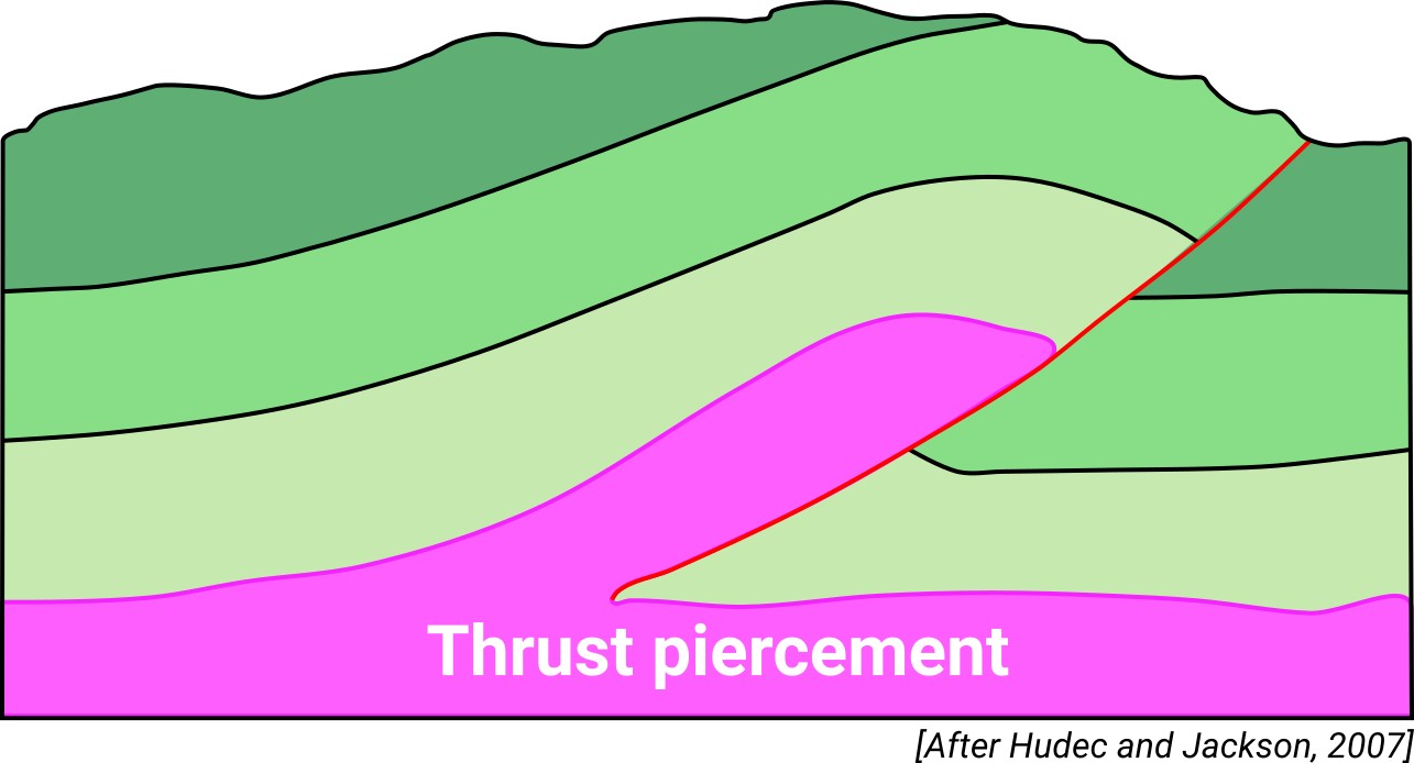
| Classif. (Hudec and Jackson, 2009) | Ductile piercement, Thrust piercement |
| Classif. (Jackson and Talbot, 1986) | Salt anticline |
| Age of evaporite flow or deformation (when deformed) | late Oligocene, Lower Oligocene |
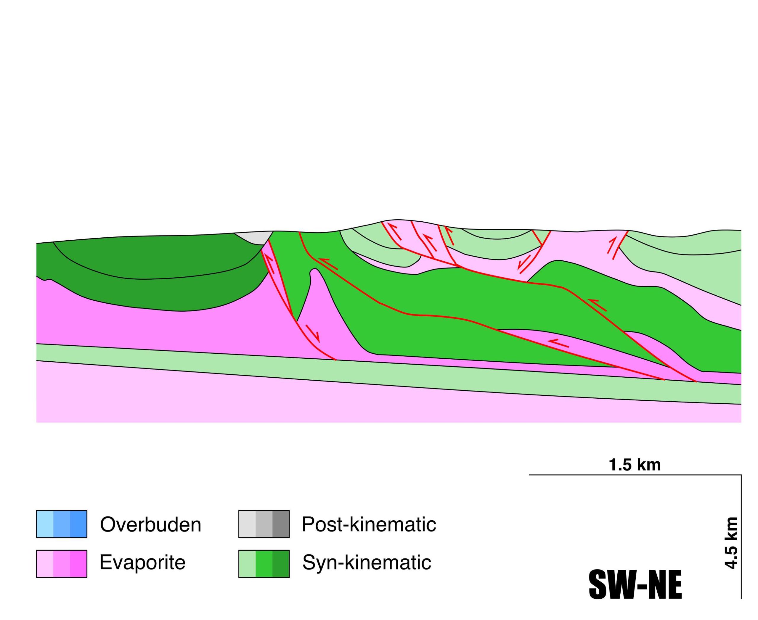
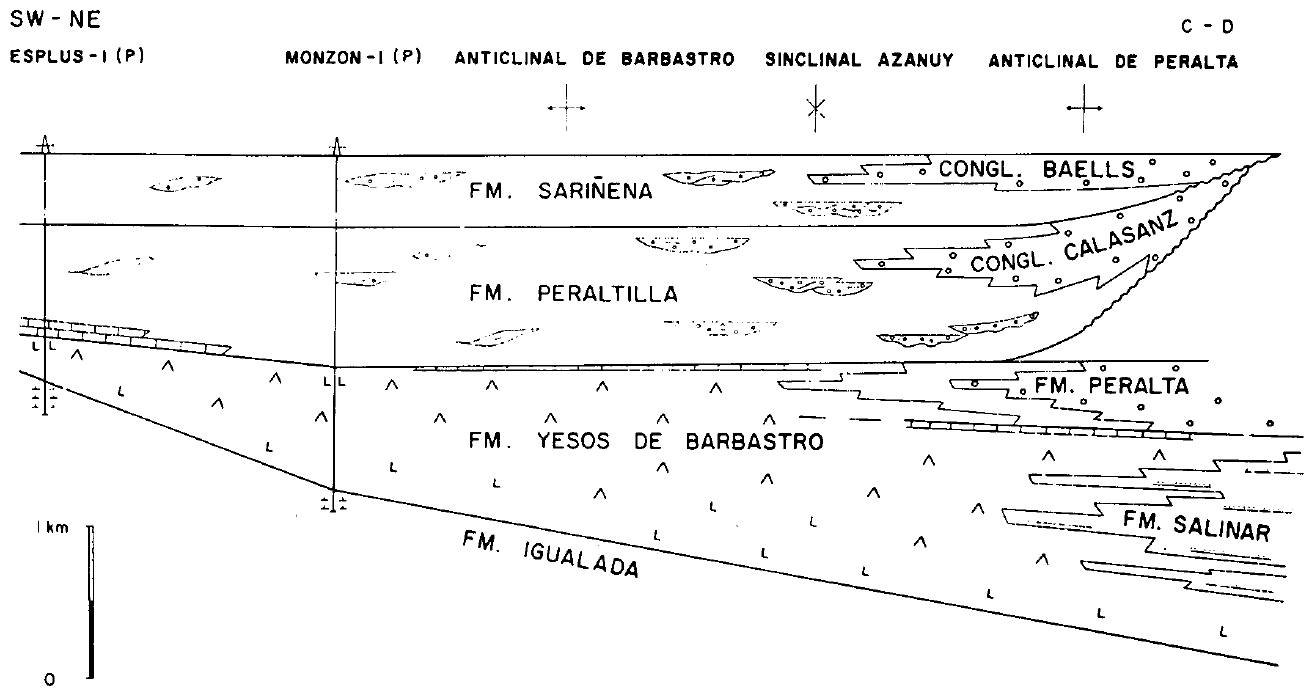
| Other comments | Main growth of the anticline coeval with the Peraltilla Fm. deposition and accompanied by a significant forelandward shift of the basin depocenter (see Senz and Zamorano, 1982). |
Generic Data
| Unique ID | 109 |
| Name | Peralta |
| Structure type | Evaporite-cored anticline |
| Deformed/Undeformed | Deformed |
| Buried/Outcropping | Buried |
| Geological setting | Ebro Basin |
| Geological Regional Setting | Northern-Central Domain |
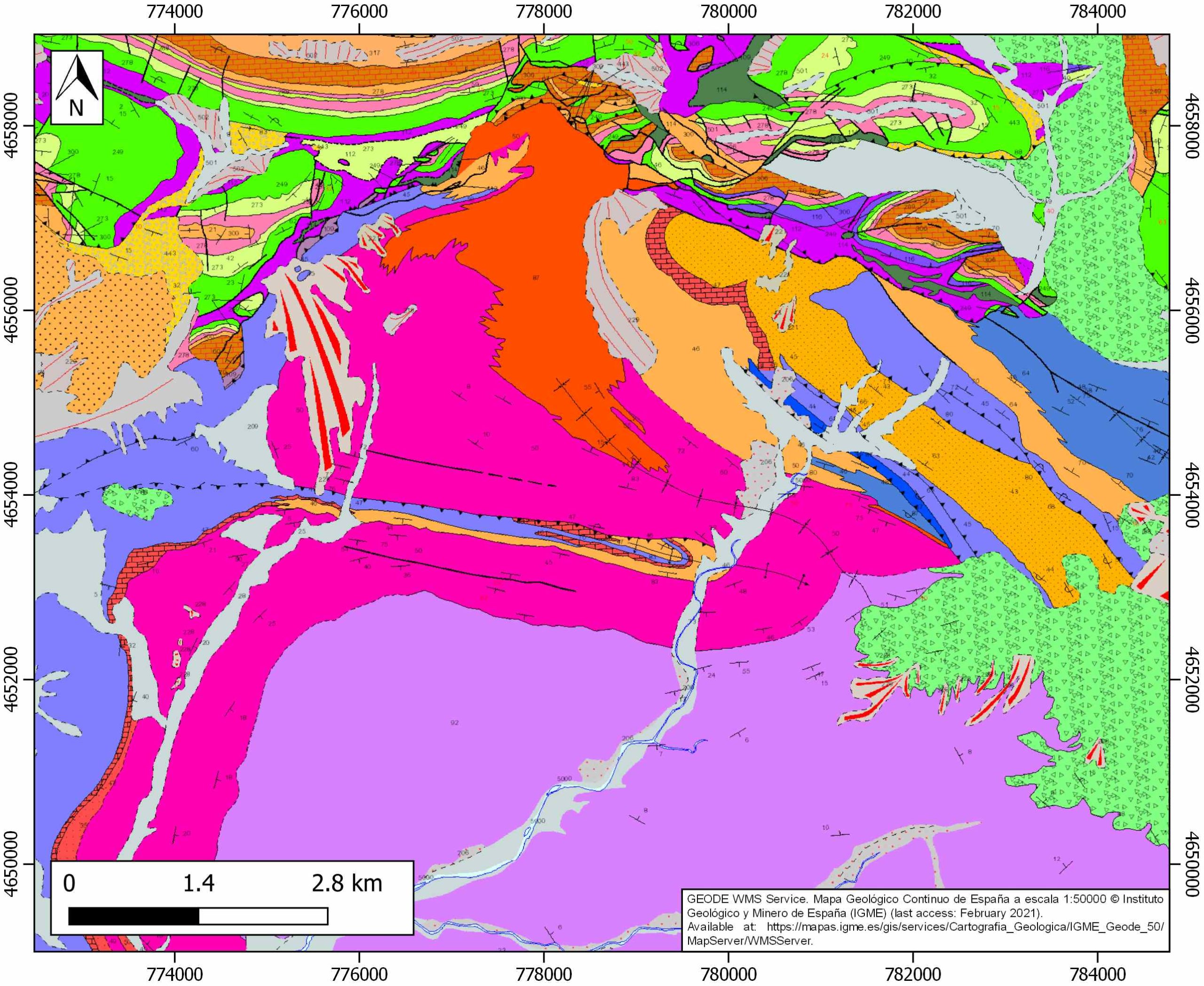
| Evaporite unit/s name | Barbastro Fm. |
| Evaporite unit/s age | Upper Priabonian-Chattian (Eocene-Oligocene) |
| Evaporite unit/s era | Cenozoic |
| Evaporite unit/s origin | Continental |
| Evaporite unit/s composition | Gypsum-Halite-Anhydrite-Shale |
| Post-kinematic unit/s (or post-evaporite units when evaporites are undeformed) | Late Chattian-Miocene (Baells Fm., sandstones, conglomerates and calcareous breccias) ; Quaternary (alluvial and colluvial detrital deposits) |
| Post-kinematic unit/s age (or post-evaporite units when evaporites are undeformed) | Late Chattian-Holocene |
| Classification (Hudec and Jackson, 2009) | Thrust piercement / Ductile piercement |
| Classification (Jackson and Talbot, 1986) | Salt anticline |
| Mining activity? | N |
| Mining activity start | |
| Mining activity end | |
| Mining galleries? | |
| Mining products | |
| Mining sub-products | |
| Evaporite flow? | Y |
| Age of evaporite flow | Rupelian-Chattian |
| Flow or deformation triggering mechanisms | Alpine compression and thrusting |
| Flow-linked structures? | Y |
| Halokinetic structures | Normal faults / joints / progressive unconformities / anticline-syncline folding |
| Post-evaporite and pre-kinematic unit/s (overbuden) | – |
| Syn-kinematic unit/s | Rupelian (Peraltilla Fm., limestones, marly limestones, sandstones and red mudstones) ; Upper Rupelian (Calasanz Fm., conglomerates and sandstones) ; Upper Rupelian (Peraltilla Fm., red shales, sandstones and conglomerates) ; Chattian (Sariñena Fm., sandstones and conglomerates) |
| Available seismic profiles | HL-07 / HL-16 / HL-7 / HL-16 / SP-10_PROL / HL-16 / HL-07 / SP-10PROL / HL-26 / HL-22 / ND-63 / ND-90 / HL-22 / HL-26 / HL-16 / CN-73 / HL-7 |
| Available boreholes | V-16-1 / Monzón-1 (not across) |
| Additional comments | Main growth of the anticline coeval with the Peraltilla Fm. Deposition and accompanied by a significant forelandward shift of the basin depocenter (see Senz and Zamorano, 1982) |
Mining Data
| UNIQUE_ID | 109 |
| Minning exploitations within <2km? | N |
| Historical/Active | |
| Exploitation name #1 | |
| Exploitation ID (Spanish National Mining Cadastre) #1 | |
| Municipality #1 | |
| Province #1 | |
| Company #1 | |
| Main minning Products #1 | |
| Exploitation name #2 | |
| Exploitation ID (Spanish National Mining Cadastre) #2 | |
| Municipality #2 | |
| Province #2 | |
| Company #2 | |
| Main minning Products #2 | |
| Exploitation name #3 | |
| Exploitation ID (Spanish National Mining Cadastre) #3 | |
| Municipality #3 | |
| Province #3 | |
| Company #3 | |
| Main minning Products #3 |
Quantitative Data
| UNIQUE_ID | 109 |
| Outcropping area (km2) | Buried |
| Horizontal intersection area (km2) (when buried) | 8.08315 |
| Depth of intersection area (km2) (when buried) | 0.8 |
| Max. Width (Km) | 1.7 |
| Max. Length (Km) | 6.7 |
| Max. Evaporites thickness (km) | 1.9 |
| Max. Deformation age (Ma) | 33.9 |
| Min. Deformation age (Ma) | 25 |
| Deformation stages | 1 |
Reference Data
| UNIQUE_ID | 109 |
| Section source | Senz, J. G., Zamorano, M., 1992. Evolución tectónica y sedimentaria durante el Priaboniense superior-Mioceno inferior, en el frente de cabalgamiento de las Sierras Marginales occidentales. Acta geológica hispánica, 27(1-2), 195-209. [link] |
| Well / Borehole availability #1 | Cámara, P., Flinch, J. F., 2017. The southern Pyrenees: a salt-based fold-and-thrust belt. In Juan I. Soto, Joan F. Flinch, Gabor Tari (eds.): Permo-Triassic Salt Provinces of Europe, North Africa and the Atlantic Margins, Elsevier, pp. 395-415. [link] |
| Well / Borehole availability #2 | Vargas, H., Gaspar-Escribano, J. M., López-Gómez, J., Van Wees, J. D., Cloetingh, S., de La Horra, R., Arche, A., 2009. A comparison of the Iberian and Ebro Basins during the Permian and Triassic, eastern Spain: A quantitative subsidence modelling approach. Tectonophysics, 474(1-2), 160-183. [link] |
| Available data (Stratigraphy) #1 | Senz, J. G., Zamorano, M., 1992. Evolución tectónica y sedimentaria durante el Priaboniense superior-Mioceno inferior, en el frente de cabalgamiento de las Sierras Marginales occidentales. Acta geológica hispánica, 27(1-2), 195-209. [link] |
| Available data (Stratigraphy) #2 | Calvet, M., Gunnell, Y., Laumonier, B., 2020. Denudation history and palaeogeography of the Pyrenees and their peripheral basins: an 84-million-year geomorphological perspective. Earth-Science Reviews, 103436. [link] |
| Available data (Stratigraphy) #3 | Santolaria, P., Casas-Sainz, A. M., Soto, R., Casas, A., 2017. Gravity modelling to assess salt tectonics in the western end of the South Pyrenean Central Unit. Journal of the Geological Society, 174(2), 269-288. [link] |
| Available data (Stratigraphy) #4 | Santolaria, P., Ayala, C., Pueyo, E. L., Rubio, F. M., Soto, R., Calvín, P., Luzón, A., Rodríguez-Pintor, A., Oliván, C., Casas‐Sainz, A. M., 2020. Structural and geophysical characterization of the western termination of the South Pyrenean triangle zone. Tectonics, 39(8), e2019TC005891. [link] |
| Available data (Stratigraphy) #5 | Cámara, P., Flinch, J. F., 2017. The southern Pyrenees: a salt-based fold-and-thrust belt. In Juan I. Soto, Joan F. Flinch, Gabor Tari (eds.): Permo-Triassic Salt Provinces of Europe, North Africa and the Atlantic Margins, Elsevier, pp. 395-415. [link] |
| Available data (Stratigraphy) #6 | n.a. |
| Regional Stratigraphy | Senz, J. G., Zamorano, M., 1992. Evolución tectónica y sedimentaria durante el Priaboniense superior-Mioceno inferior, en el frente de cabalgamiento de las Sierras Marginales occidentales. Acta geológica hispánica, 27(1-2), 195-209. [link] |
| Seismic data availability #1 | Santolaria, P., Ayala, C., Pueyo, E. L., Rubio, F. M., Soto, R., Calvín, P., Luzón, A., Rodríguez-Pintor, A., Oliván, C., Casas‐Sainz, A. M., 2020. Structural and geophysical characterization of the western termination of the South Pyrenean triangle zone. Tectonics, 39(8), e2019TC005891. [link] |
| Seismic data availability #2 | Gil, J. A., Jurado, M. J., 1998. Geological interpretation and numerical modelling of salt movement in the Barbastro–Balaguer anticline, southern Pyrenees. Tectonophysics, 293(3-4), 141-155. [link] |
| Seismic data availability #3 | Santolaria, P., Casas-Sainz, A. M., Soto, R., Casas, A., 2017. Gravity modelling to assess salt tectonics in the western end of the South Pyrenean Central Unit. Journal of the Geological Society, 174(2), 269-288. [link] |
| Available data (Structure) #1 | Senz, J. G., Zamorano, M., 1992. Evolución tectónica y sedimentaria durante el Priaboniense superior-Mioceno inferior, en el frente de cabalgamiento de las Sierras Marginales occidentales. Acta geológica hispánica, 27(1-2), 195-209. [link] |
| Available data (Structure) #2 | Peña, B. M., Pocoví, J. A., 1988. El amortiguamiento frontal de la estructura de la cobertera surpirenaica y su relación con el anticlinal de Barbastro-Balaguer. Acta geológica hispánica, 81-94. [link] |
| Available data (Structure) #3 | Gil, J. A., Jurado, M. J., 1998. Geological interpretation and numerical modelling of salt movement in the Barbastro–Balaguer anticline, southern Pyrenees. Tectonophysics, 293(3-4), 141-155. [link] |
| Available data (Structure) #4 | Sancho-Marcén, C., 1989. Deformaciones asociadas a la actividad diapírica cuaternaria del anticlinal de Barbastro (Provincia de Huesca). Cuaternario y Geomorfología, 3(1-4), 35-43. [link] |
| Available data (Structure) #5 | Santolaria, P., Casas-Sainz, A. M., Soto, R., Casas, A., 2017. Gravity modelling to assess salt tectonics in the western end of the South Pyrenean Central Unit. Journal of the Geological Society, 174(2), 269-288. [link] |
| Available data (Structure) #6 | Cámara, P., Flinch, J. F., 2017. The southern Pyrenees: a salt-based fold-and-thrust belt. In Juan I. Soto, Joan F. Flinch, Gabor Tari (eds.): Permo-Triassic Salt Provinces of Europe, North Africa and the Atlantic Margins, Elsevier, pp. 395-415. [link] |
| Available data (Analogue modelling) #1 | Gil, J. A., Jurado, M. J., 1998. Geological interpretation and numerical modelling of salt movement in the Barbastro–Balaguer anticline, southern Pyrenees. Tectonophysics, 293(3-4), 141-155. [link] |
| Available data (Analogue modelling) #2 | n.a. |
| Available data (Analogue modelling) #3 | n.a. |
| Available data (Gravimetry – Tomography) #1 | Santolaria, P., Ayala, C., Pueyo, E. L., Rubio, F. M., Soto, R., Calvín, P., Luzón, A., Rodríguez-Pintor, A., Oliván, C., Casas‐Sainz, A. M., 2020. Structural and geophysical characterization of the western termination of the South Pyrenean triangle zone. Tectonics, 39(8), e2019TC005891. [link] |
| Available data (Gravimetry – Tomography) #2 | Santolaria, P., Casas-Sainz, A. M., Soto, R., Casas, A., 2017. Gravity modelling to assess salt tectonics in the western end of the South Pyrenean Central Unit. Journal of the Geological Society, 174(2), 269-288. [link] |
| Available data (Gravimetry – Tomography) #3 | Santolaria, P., Rubio, F. M., Ayala, C., Pueyo, E. L., Rodríguez-Pintó, A., Soto, R., Casas, A. M., 2016. Gravimetría preliminar del antepaís Pirenaico central; distribución de las evaporitas y geometría de zócalo. [link] |
| Available data (Geochemistry) #1 | Cendón Sevilla, D. I., 1999. Evolución geoquímica de cuencas evaporíticas terciarias: implicaciones en la composición isotópica disuelto en el océano durante el terciario [Ph.D. thesis]: University of Barcelona, 335p. [link] |
| Available data (Geochemistry) #2 | Salvany, J. M., Bastida, J., 2004. Análisis litoestratigráfico del Keuper surpirenaico central. Revista de la Sociedad Geológica de España, 17(1), 3-26. [link] |
| Available data (Geochemistry) #3 | Gómez-Gras, D., Roigé, M., Fondevilla, V., Oms, O., Boya, S., Remacha, E., 2016. Provenance constraints on the Tremp Formation paleogeography (southern Pyrenees): Ebro Massif vs Pyrenees sources. Cretaceous Research, 57, 414-427. [link] |
| Available data (Geochemistry) #4 | n.a. |
| Available data (Petrophysics) #1 | Santolaria, P., Casas-Sainz, A. M., Soto, R., Casas, A., 2017. Gravity modelling to assess salt tectonics in the western end of the South Pyrenean Central Unit. Journal of the Geological Society, 174(2), 269-288. [link] |
| Available data (Petrophysics) #2 | Oliván, C., Pueyo, E. L., Pocoví, A., Luzón, A., Martínez-Peña, M. B., 2008. Fábricas magnéticas (ASM) en el anticlinal de Barbastro–Balaguer (Pirineo Central): implicaciones cinemáticas. Geotemas, 10, 1239-1242. [link] |
| IGME Geological Map (MAGNA50) Sheet number | 326-Monzón. [link] |
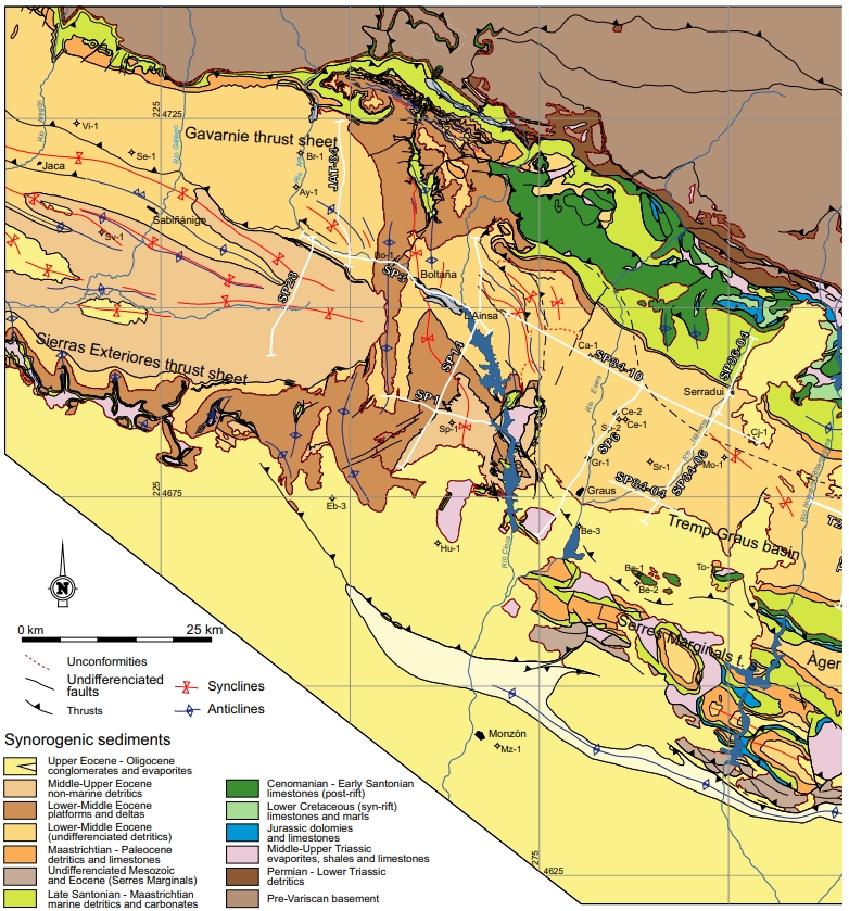
| Other Maps #1 (source) | Muñoz, J. A., Mencos, J., Roca, E., Carrera, N., Gratacós, O., Ferrer, O., Fernández, O., 2018. The structure of the South-Central-Pyrenean fold and thrust belt as constrained by subsurface data. Geologica Acta, 16(4), 439-460. [link] |
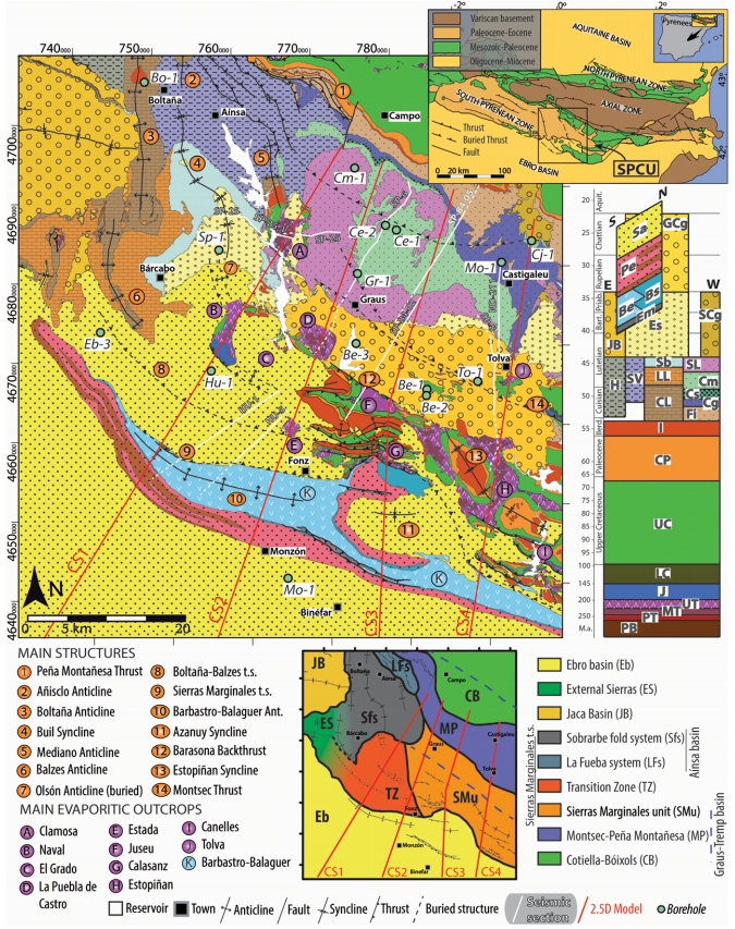
| Other Maps #2 (source) | Santolaria, P., Casas-Sainz, A. M., Soto, R., Casas, A., 2017. Gravity modelling to assess salt tectonics in the western end of the South Pyrenean Central Unit. Journal of the Geological Society, 174(2), 269-288. [link] |
| Other related references #1 | Muñoz, J. A., Mencos, J., Roca, E., Carrera, N., Gratacós, O., Ferrer, O., Fernández, O., 2018. The structure of the South-Central-Pyrenean fold and thrust belt as constrained by subsurface data. Geologica Acta, 16(4), 439-460. [link] |
| Other related references #2 | Meigs, A. J., 1997. Sequential development of selected Pyrenean thrust faults. Journal of Structural Geology, 19(3-4), 481-502. [link] |
| Other related references #3 | Torné, M., 1989. Modelización gravimétrica en 3d de un sector de la depresión central catalana y sierras marginales. Revista de la Sociedad Geológica de España, 2, 133-142. [link] |
| Other related references #4 | Garrido-Megías, A., 1972. Precisiones sobre la» mise en place» del manto de Gavarnie en el borde norte del valle del Ebro (Región de Barbastro, provincia de Huesca). Acta geológica hispánica, 50-52. [link] |
Well and Seismic Data
| UNIQUE_ID | 109 |
| Seismic survey name #1 | DHLS |
| Across structure? #1 | Y |
| Seismic profile ID (IGME) #1 | 5620 |
| Seismic profile code #1 | 8644 |
| Seismic profile name #1 | HL-07 |
| Seismic survey year #1 | |
| Data repository #1 | SIGEOF Data Catalogue (Private access section). ©Instituto Geológico y Minero de España (IGME). https://info.igme.es/SIGEOF/ |
| Length (km) #1 | 33.10 |
| Seismic survey name #2 | DHLS |
| Across structure? #2 | Y |
| Seismic profile ID (IGME) #2 | 5625 |
| Seismic profile code #2 | 8649 |
| Seismic profile name #2 | HL-16 |
| Seismic survey year #2 | |
| Data repository #2 | SIGEOF Data Catalogue (Private access section). ©Instituto Geológico y Minero de España (IGME). https://info.igme.es/SIGEOF/ |
| Length (km) #2 | 74.77 |
| Seismic survey name #3 | 11D-ST-157 |
| Across structure? #3 | Y |
| Seismic profile ID (IGME) #3 | 14121 |
| Seismic profile code #3 | 18856 |
| Seismic profile name #3 | HL-7 |
| Seismic survey year #3 | 1962 |
| Data repository #3 | SIGEOF Data Catalogue (Private access section). ©Instituto Geológico y Minero de España (IGME). https://info.igme.es/SIGEOF/ |
| Length (km) #3 | 33.04 |
| Seismic survey name #4 | 11E-ST-153 |
| Across structure? #4 | Y |
| Seismic profile ID (IGME) #4 | 14145 |
| Seismic profile code #4 | 18880 |
| Seismic profile name #4 | HL-16 |
| Seismic survey year #4 | 1961 |
| Data repository #4 | SIGEOF Data Catalogue (Private access section). ©Instituto Geológico y Minero de España (IGME). https://info.igme.es/SIGEOF/ |
| Length (km) #4 | 44.92 |
| Seismic survey name #5 | 11D1-SP |
| Across structure? #5 | N (within 3km) |
| Seismic profile ID (IGME) #5 | 10274 |
| Seismic profile code #5 | 14902 |
| Seismic profile name #5 | SP-10_PROL |
| Seismic survey year #5 | 1962 |
| Data repository #5 | SIGEOF Data Catalogue (Section available under request). ©Instituto Geológico y Minero de España (IGME). https://info.igme.es/SIGEOF/ |
| Length (km) #5 | 25.32 |
| Seismic survey name #6 | DHLS |
| Across structure? #6 | N (within 3km) |
| Seismic profile ID (IGME) #6 | 5625 |
| Seismic profile code #6 | 8649 |
| Seismic profile name #6 | HL-16 |
| Seismic survey year #6 | |
| Data repository #6 | SIGEOF Data Catalogue (Private access section). ©Instituto Geológico y Minero de España (IGME). https://info.igme.es/SIGEOF/ |
| Length (km) #6 | 74.77 |
| Seismic survey name #7 | DHLS |
| Across structure? #7 | N (within 3km) |
| Seismic profile ID (IGME) #7 | 5620 |
| Seismic profile code #7 | 8644 |
| Seismic profile name #7 | HL-07 |
| Seismic survey year #7 | |
| Data repository #7 | SIGEOF Data Catalogue (Private access section). ©Instituto Geológico y Minero de España (IGME). https://info.igme.es/SIGEOF/ |
| Length (km) #7 | 33.10 |
| Seismic survey name #8 | 0116A80G |
| Across structure? #8 | N (within 3km) |
| Seismic profile ID (IGME) #8 | 5362 |
| Seismic profile code #8 | 7730 |
| Seismic profile name #8 | SP-10PROL |
| Seismic survey year #8 | 1980 |
| Data repository #8 | SIGEOF Data Catalogue (Private access section). ©Instituto Geológico y Minero de España (IGME). https://info.igme.es/SIGEOF/ |
| Length (km) #8 | 27.83 |
| Seismic survey name #9 | DHLS |
| Across structure? #9 | N (within 3km) |
| Seismic profile ID (IGME) #9 | 5632 |
| Seismic profile code #9 | 8656 |
| Seismic profile name #9 | HL-26 |
| Seismic survey year #9 | |
| Data repository #9 | SIGEOF Data Catalogue (Private access section). ©Instituto Geológico y Minero de España (IGME). https://info.igme.es/SIGEOF/ |
| Length (km) #9 | 8.67 |
| Seismic survey name #10 | DHLS |
| Across structure? #10 | N (within 3km) |
| Seismic profile ID (IGME) #10 | 5629 |
| Seismic profile code #10 | 8653 |
| Seismic profile name #10 | HL-22 |
| Seismic survey year #10 | |
| Data repository #10 | SIGEOF Data Catalogue (Private access section). ©Instituto Geológico y Minero de España (IGME). https://info.igme.es/SIGEOF/ |
| Length (km) #10 | 4.73 |
| Seismic survey name #11 | 11D1-ND |
| Across structure? #11 | N (within 3km) |
| Seismic profile ID (IGME) #11 | 10149 |
| Seismic profile code #11 | 14777 |
| Seismic profile name #11 | ND-63 |
| Seismic survey year #11 | 1962 |
| Data repository #11 | SIGEOF Data Catalogue (Private access section). ©Instituto Geológico y Minero de España (IGME). https://info.igme.es/SIGEOF/ |
| Length (km) #11 | 13.34 |
| Seismic survey name #12 | 11D-ST-152 |
| Across structure? #12 | N (within 3km) |
| Seismic profile ID (IGME) #12 | 14105 |
| Seismic profile code #12 | 18840 |
| Seismic profile name #12 | ND-90 |
| Seismic survey year #12 | 1962 |
| Data repository #12 | SIGEOF Data Catalogue (Private access section). ©Instituto Geológico y Minero de España (IGME). https://info.igme.es/SIGEOF/ |
| Length (km) #12 | 16.61 |
| Seismic survey name #13 | 11D-ST-157 |
| Across structure? #13 | N (within 3km) |
| Seismic profile ID (IGME) #13 | 14128 |
| Seismic profile code #13 | 18863 |
| Seismic profile name #13 | HL-22 |
| Seismic survey year #13 | 1962 |
| Data repository #13 | SIGEOF Data Catalogue (Private access section). ©Instituto Geológico y Minero de España (IGME). https://info.igme.es/SIGEOF/ |
| Length (km) #13 | 5.58 |
| Seismic survey name #14 | 11D-ST-157 |
| Across structure? #14 | N (within 3km) |
| Seismic profile ID (IGME) #14 | 14126 |
| Seismic profile code #14 | 18861 |
| Seismic profile name #14 | HL-26 |
| Seismic survey year #14 | 1962 |
| Data repository #14 | SIGEOF Data Catalogue (Private access section). ©Instituto Geológico y Minero de España (IGME). https://info.igme.es/SIGEOF/ |
| Length (km) #14 | 8.58 |
| Seismic survey name #15 | 11E-ST-153 |
| Across structure? #15 | N (within 3km) |
| Seismic profile ID (IGME) #15 | 14145 |
| Seismic profile code #15 | 18880 |
| Seismic profile name #15 | HL-16 |
| Seismic survey year #15 | 1961 |
| Data repository #15 | SIGEOF Data Catalogue (Private access section). ©Instituto Geológico y Minero de España (IGME). https://info.igme.es/SIGEOF/ |
| Length (km) #15 | 44.92 |
| Seismic survey name #16 | 11D-C003 |
| Across structure? #16 | N (within 3km) |
| Seismic profile ID (IGME) #16 | 14085 |
| Seismic profile code #16 | 18819 |
| Seismic profile name #16 | CN-73 |
| Seismic survey year #16 | |
| Data repository #16 | SIGEOF Data Catalogue (Private access section). ©Instituto Geológico y Minero de España (IGME). https://info.igme.es/SIGEOF/ |
| Length (km) #16 | 17.28 |
| Seismic survey name #17 | 11D-ST-157 |
| Across structure? #17 | N (within 3km) |
| Seismic profile ID (IGME) #17 | 14121 |
| Seismic profile code #17 | 18856 |
| Seismic profile name #17 | HL-7 |
| Seismic survey year #17 | 1962 |
| Data repository #17 | SIGEOF Data Catalogue (Private access section). ©Instituto Geológico y Minero de España (IGME). https://info.igme.es/SIGEOF/ |
| Length (km) #17 | 33.04 |
| Seismic survey name #18 | |
| Across structure? #18 | |
| Seismic profile ID (IGME) #18 | |
| Seismic profile code #18 | |
| Seismic profile name #18 | |
| Seismic survey year #18 | |
| Data repository #18 | |
| Length (km) #18 | |
| Seismic survey name #19 | |
| Across structure? #19 | |
| Seismic profile ID (IGME) #19 | |
| Seismic profile code #19 | |
| Seismic profile name #19 | |
| Seismic survey year #19 | |
| Data repository #19 | |
| Length (km) #19 | |
| Seismic survey name #20 | |
| Across structure? #20 | |
| Seismic profile ID (IGME) #20 | |
| Seismic profile code #20 | |
| Seismic profile name #20 | |
| Seismic survey year #20 | |
| Data repository #20 | |
| Length (km) #20 | |
| Seismic survey name #21 | |
| Across structure? #21 | |
| Seismic profile ID (IGME) #21 | |
| Seismic profile code #21 | |
| Seismic profile name #21 | |
| Seismic survey year #21 | |
| Data repository #21 | |
| Length (km) #21 | |
| Borehole name #1 | |
| Company #1 | |
| Traget #1 | |
| Across structure? #1 | |
| Borehole name #2 | |
| Company #2 | |
| Traget #2 | |
| Across structure? #2 | |
| Borehole name #3 | |
| Company #3 | |
| Traget #3 | |
| Across structure? #3 | |
| Borehole name #4 | |
| Company #4 | |
| Traget #4 | |
| Across structure? #4 | |
| Borehole name #5 | |
| Company #5 | |
| Traget #5 | |
| Across structure? #5 | |
| Borehole name #6 | |
| Company #6 | |
| Traget #6 | |
| Across structure? #6 | |
| Borehole name #7 | |
| Company #7 | |
| Traget #7 | |
| Across structure? #7 | |
| Borehole name #8 | |
| Company #8 | |
| Traget #8 | |
| Across structure? #8 | |
| Borehole name #9 | |
| Company #9 | |
| Traget #9 | |
| Across structure? #9 | |
| Borehole name #10 | |
| Company #10 | |
| Traget #10 | |
| Across structure? #10 | |
| Borehole name #11 | |
| Company #11 | |
| Traget #11 | |
| Across structure? #11 | |
| Borehole name #12 | |
| Company #12 | |
| Traget #12 | |
| Across structure? #12 | |
| Borehole name #13 | |
| Company #13 | |
| Traget #13 | |
| Across structure? #13 | |
| Borehole name #14 | |
| Company #14 | |
| Traget #14 | |
| Across structure? #14 | |
| Borehole name #15 | |
| Company #15 | |
| Traget #15 | |
| Across structure? #15 |
Geographical Data (EPSG:4326 - WGS 84)
| UNIQUE_ID | 109 |
| X Centroid (Structure shape) | 0.354316 |
| Y Centroid (Structure shape) | 0.354316 |
| Xmin (Structure shape) | 0.313965 |
| Xmax (Structure shape) | 0.394768 |
| Ymin (Structure shape) | 41.974979 |
| Ymax (Structure shape) | 42.000163 |
| Xmin seismic line #1 | 0.247708 |
| Xmax seismic line #1 | 0.403406 |
| Ymin seismic line #1 | 41.736985 |
| Ymax seismic line #1 | 42.005163 |
| Xmin seismic line #2 | -0.155243 |
| Xmax seismic line #2 | 0.333793 |
| Ymin seismic line #2 | 41.461058 |
| Ymax seismic line #2 | 42.011080 |
| Xmin seismic line #3 | 0.245703 |
| Xmax seismic line #3 | 0.401490 |
| Ymin seismic line #3 | 41.735846 |
| Ymax seismic line #3 | 42.004675 |
| Xmin seismic line #4 | 0.068603 |
| Xmax seismic line #4 | 0.331319 |
| Ymin seismic line #4 | 41.667665 |
| Ymax seismic line #4 | 42.010446 |
| Xmin seismic line #5 | 0.282745 |
| Xmax seismic line #5 | 0.458239 |
| Ymin seismic line #5 | 42.006030 |
| Ymax seismic line #5 | 42.190745 |
| Xmin seismic line #6 | -0.155243 |
| Xmax seismic line #6 | 0.333793 |
| Ymin seismic line #6 | 41.461058 |
| Ymax seismic line #6 | 42.011080 |
| Xmin seismic line #7 | 0.247708 |
| Xmax seismic line #7 | 0.403406 |
| Ymin seismic line #7 | 41.736985 |
| Ymax seismic line #7 | 42.005163 |
| Xmin seismic line #8 | 0.276069 |
| Xmax seismic line #8 | 0.464405 |
| Ymin seismic line #8 | 41.994966 |
| Ymax seismic line #8 | 42.195640 |
| Xmin seismic line #9 | 0.406156 |
| Xmax seismic line #9 | 0.422880 |
| Ymin seismic line #9 | 41.879713 |
| Ymax seismic line #9 | 41.953885 |
| Xmin seismic line #10 | 0.255680 |
| Xmax seismic line #10 | 0.296847 |
| Ymin seismic line #10 | 41.978772 |
| Ymax seismic line #10 | 42.007913 |
| Xmin seismic line #11 | 0.395729 |
| Xmax seismic line #11 | 0.494656 |
| Ymin seismic line #11 | 42.003063 |
| Ymax seismic line #11 | 42.087184 |
| Xmin seismic line #12 | 0.306088 |
| Xmax seismic line #12 | 0.478564 |
| Ymin seismic line #12 | 41.940572 |
| Ymax seismic line #12 | 41.969303 |
| Xmin seismic line #13 | 0.254089 |
| Xmax seismic line #13 | 0.302876 |
| Ymin seismic line #13 | 41.972520 |
| Ymax seismic line #13 | 42.006874 |
| Xmin seismic line #14 | 0.403712 |
| Xmax seismic line #14 | 0.420344 |
| Ymin seismic line #14 | 41.879404 |
| Ymax seismic line #14 | 41.953082 |
| Xmin seismic line #15 | 0.068603 |
| Xmax seismic line #15 | 0.331319 |
| Ymin seismic line #15 | 41.667665 |
| Ymax seismic line #15 | 42.010446 |
| Xmin seismic line #16 | 0.200130 |
| Xmax seismic line #16 | 0.295175 |
| Ymin seismic line #16 | 41.839868 |
| Ymax seismic line #16 | 41.977640 |
| Xmin seismic line #17 | 0.245703 |
| Xmax seismic line #17 | 0.401490 |
| Ymin seismic line #17 | 41.735846 |
| Ymax seismic line #17 | 42.004675 |
| Xmin seismic line #18 | |
| Xmax seismic line #18 | |
| Ymin seismic line #18 | |
| Ymax seismic line #18 | |
| Xmin seismic line #19 | |
| Xmax seismic line #19 | |
| Ymin seismic line #19 | |
| Ymax seismic line #19 | |
| Xmin seismic line #20 | |
| Xmax seismic line #20 | |
| Ymin seismic line #20 | |
| Ymax seismic line #20 | |
| Xmin seismic line #21 | |
| Xmax seismic line #21 | |
| Ymin seismic line #21 | |
| Ymax seismic line #21 | |
| X borehole #1 | |
| Y borehole #1 | |
| X borehole #2 | |
| Y borehole #2 | |
| X borehole #3 | |
| Y borehole #3 | |
| X borehole #4 | |
| Y borehole #4 | |
| X borehole #5 | |
| Y borehole #5 | |
| X borehole #6 | |
| Y borehole #6 | |
| X borehole #7 | |
| Y borehole #7 | |
| X borehole #8 | |
| Y borehole #8 | |
| X borehole #9 | |
| Y borehole #9 | |
| X borehole #10 | |
| Y borehole #10 | |
| X borehole #11 | |
| Y borehole #11 | |
| X borehole #12 | |
| Y borehole #12 | |
| X borehole #13 | |
| Y borehole #13 | |
| X borehole #14 | |
| Y borehole #14 | |
| X borehole #15 | |
| Y borehole #15 |

