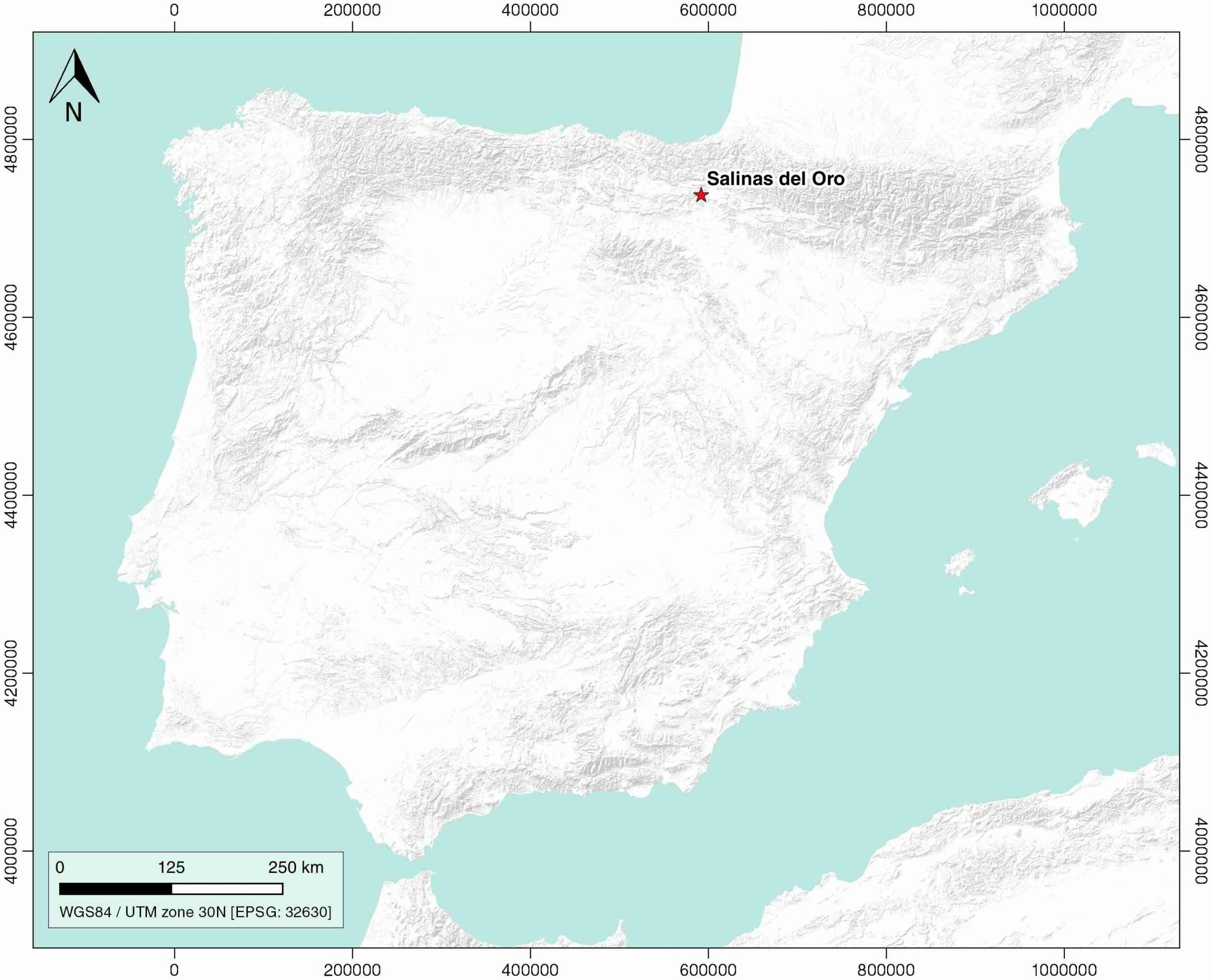
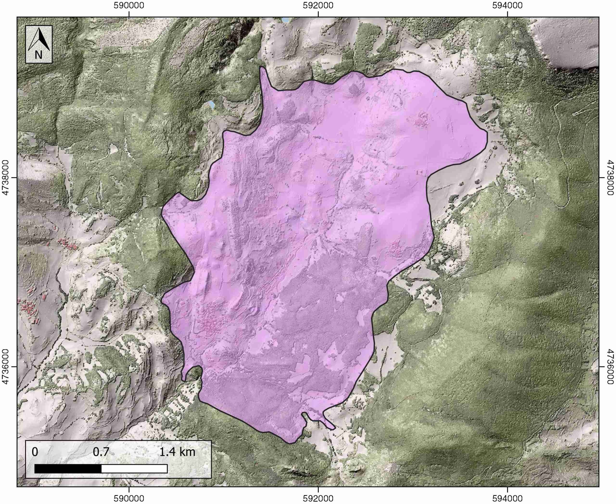
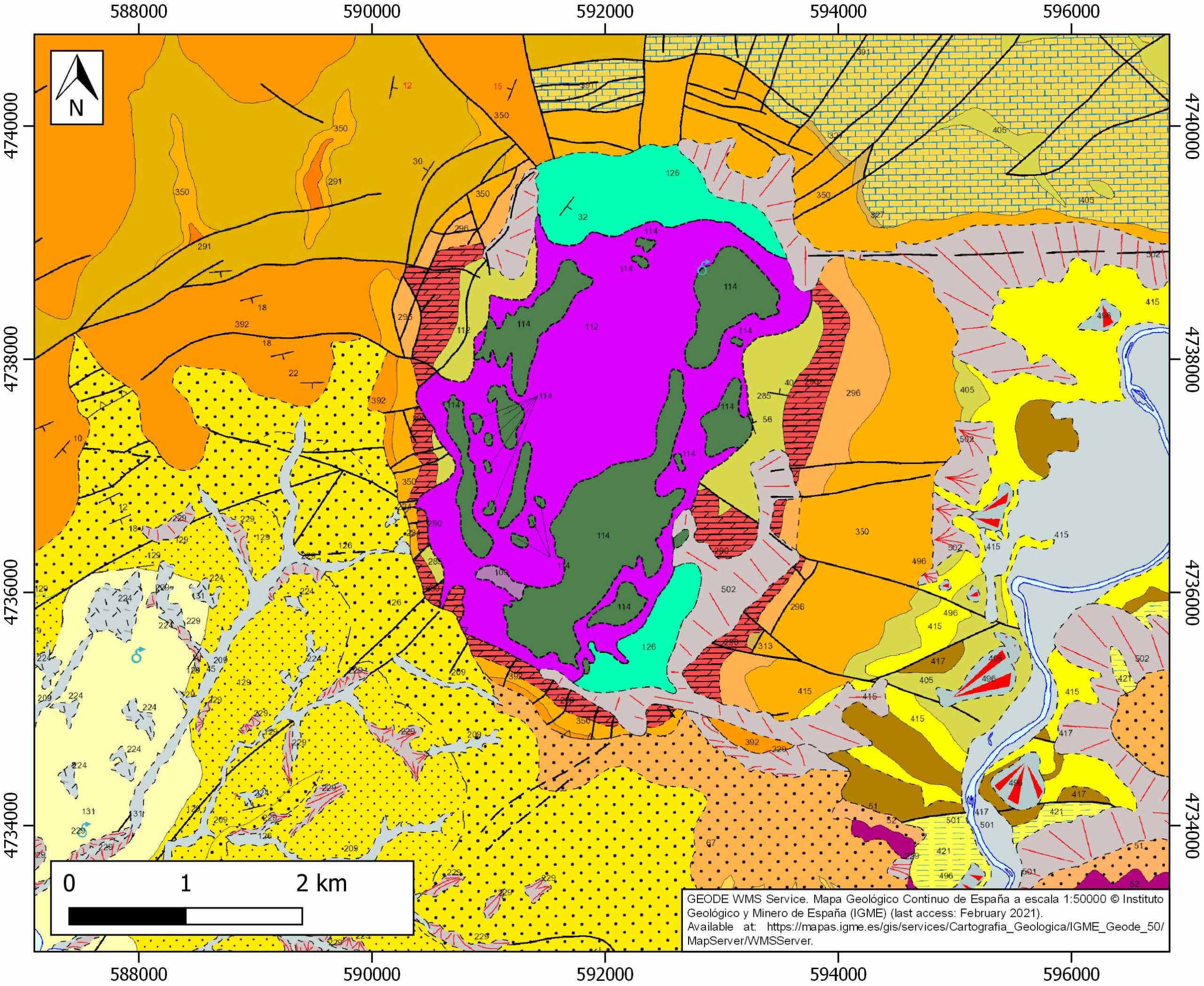
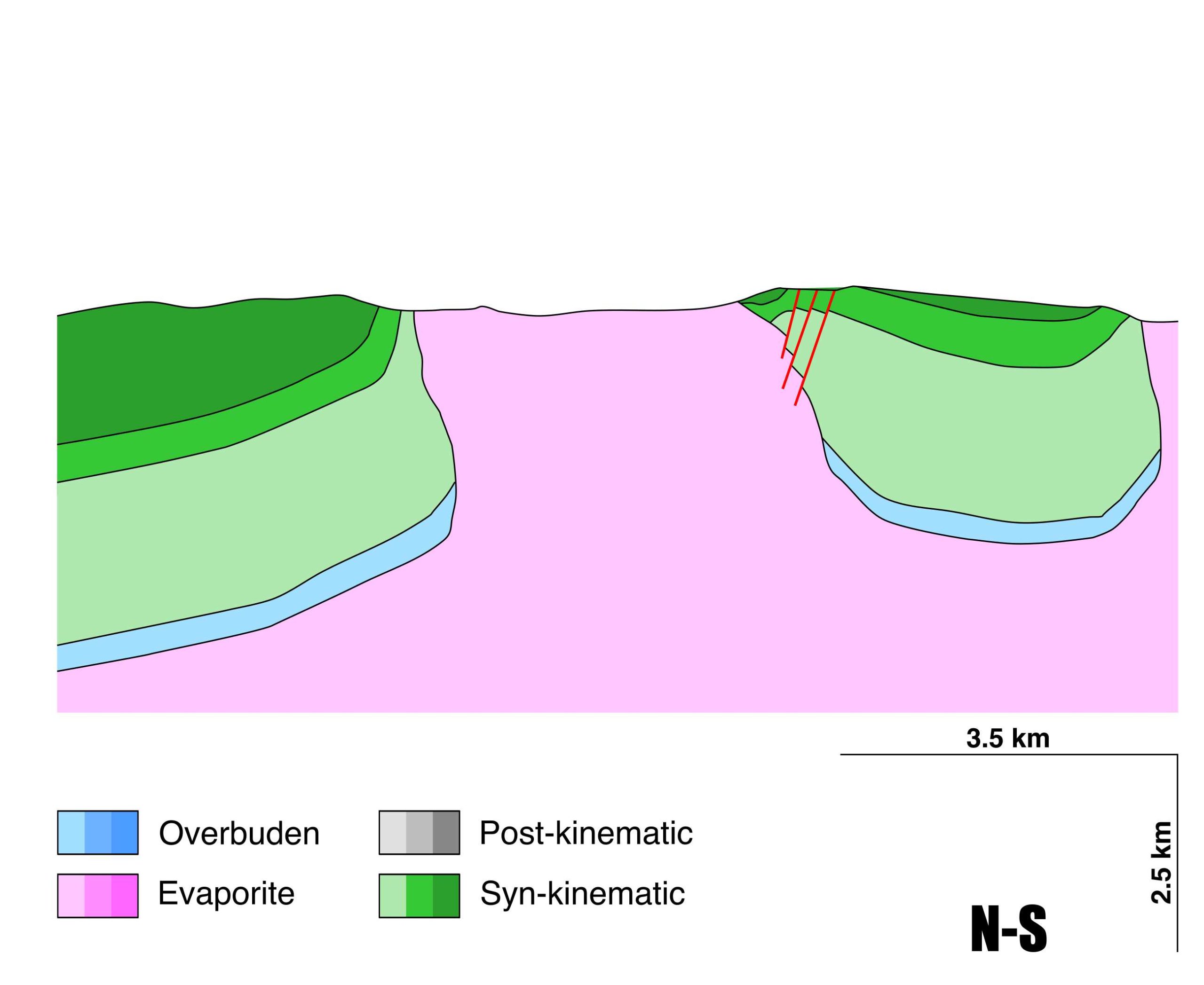
Salinas del Oro
ID #024
General Information
| Structure type | Evaporite Diapir |
| Deformed/Undeformed | Undeformed |
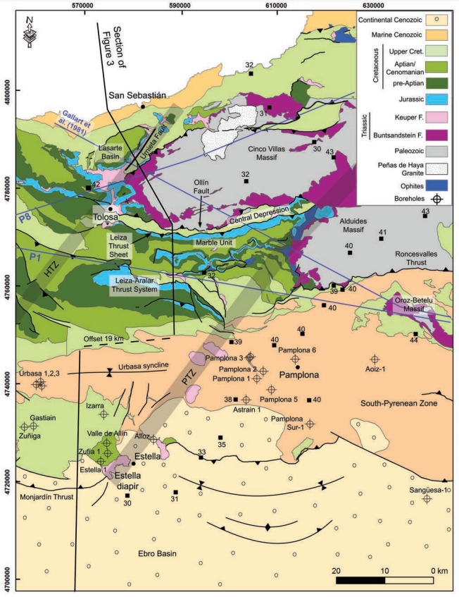
| Geological Setting | Basque-Cantabrian Basin, Navarra-Álava trough |
| Outcropping/buried | Outcropping |
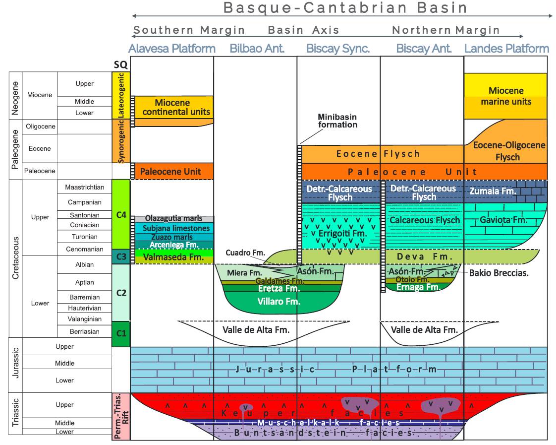
| Evaporite unit/s name | Keuper facies |
| Evaporite unit/s age | Carnian-Rhaetian (Upper Triassic) |
| Evaporite unit/s origin | Marine |
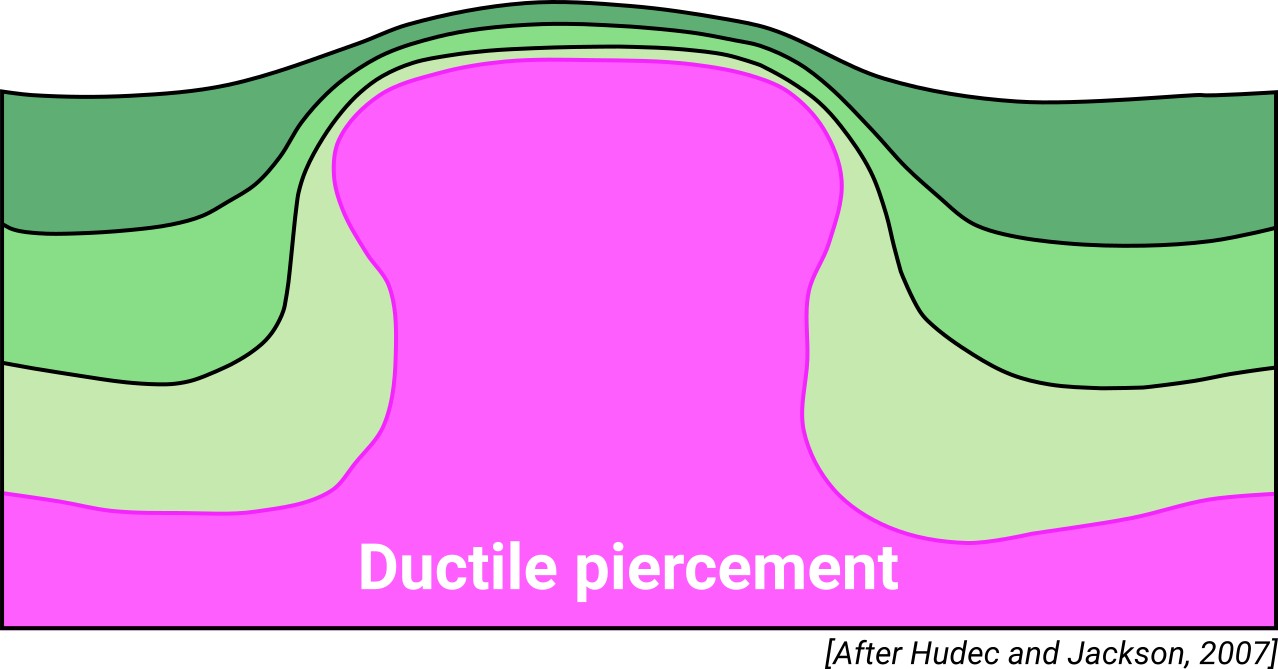
| Classif. (Hudec and Jackson, 2009) | Ductile piercement |
| Classif. (Jackson and Talbot, 1986) | Salt wall |
| Age of evaporite flow or deformation (when deformed) | Danian to Burdigalian, Lower Cretaceous |
| Other comments | Alignment of the Salinas del Oro, Anoz, Alloz, Estella, Ollo, Echalecu and Iza along the Pamplona fault. |
Generic Data
| Unique ID | 24 |
| Name | Salinas del Oro |
| Structure type | Evaporite diapir |
| Deformed/Undeformed | Deformed |
| Buried/Outcropping | Outcropping |
| Geological setting | Basque-Cantabrian Basin |
| Geological Regional Setting | Navarra-Álava trough |
| Evaporite unit/s name | Keuper facies |
| Evaporite unit/s age | Carnian-Rhaetian (Upper Triassic) |
| Evaporite unit/s era | Mesozoic |
| Evaporite unit/s origin | Marine |
| Evaporite unit/s composition | Gypsum-Halite-Anhydrite-Claystone-Ophites |
| Post-kinematic unit/s (or post-evaporite units when evaporites are undeformed) | Quaternary (alluvial and colluvial detrital deposits) |
| Post-kinematic unit/s age (or post-evaporite units when evaporites are undeformed) | Pleistocene-Holocene |
| Classification (Hudec and Jackson, 2009) | Ductile piercement |
| Classification (Jackson and Talbot, 1986) | Salt wall |
| Mining activity? | Y |
| Mining activity start | Roman Empire |
| Mining activity end | Active |
| Mining galleries? | |
| Mining products | Salt springs, Common salt |
| Mining sub-products | – |
| Evaporite flow? | Y |
| Age of evaporite flow | Berriasian – Albian (early stage) and Danian – Burdigalian (main stage) |
| Flow or deformation triggering mechanisms | Pamplona fault |
| Flow-linked structures? | Y |
| Halokinetic structures | Progressive unconformities / radial normal and thrust faults / radial joints / thickness variations |
| Post-evaporite and pre-kinematic unit/s (overbuden) | Jurassic (dolostones, marls and oolitic limestones) |
| Syn-kinematic unit/s | Upper Weald facies (sandstones) / Aptian-middle Albian (Urgonian Group: marlstones, marly limestones, packstones, carbonate brecchias, rudistid limestones; Punta del Bakio Unit: turbidites, mudstones and carbonate grainstones) / Danian-Selandian (dolomites and limestones) / Thanetian-Ypresian (limestones and marls) / Lutetian-Bartonian (limestones and marls) / Priabonian-Burdigalian (shales, sandstones and conglomerates) |
| Available seismic profiles | AN-9 / AN-14 / AN-1 / AN-12 / AN-10 / AN-01 / AN-9 / AN-01 / AN-11 / P-12 / AN-16 / AN-7 / AN-18 / AN-14 / P-7-4 / P-21 / |
| Available boreholes | |
| Additional comments | Alignment of the Salinas del Oro, Anoz, Alloz, Estella, Ollo, Echalecu and Iza along the Pamplona fault. |
Mining Data
| UNIQUE_ID | 24 |
| Minning exploitations within <2km? | Y |
| Historical/Active | Active |
| Exploitation name #1 | LAS SALINAS |
| Exploitation ID (Spanish National Mining Cadastre) #1 | 3199 |
| Municipality #1 | Salinas de Oro |
| Province #1 | NAVARRA |
| Company #1 | AYUNTAMIENTO DE SALINAS DE ORO |
| Main minning Products #1 | Salt springs, Common salt |
| Exploitation name #2 | |
| Exploitation ID (Spanish National Mining Cadastre) #2 | |
| Municipality #2 | |
| Province #2 | |
| Company #2 | |
| Main minning Products #2 | |
| Exploitation name #3 | |
| Exploitation ID (Spanish National Mining Cadastre) #3 | |
| Municipality #3 | |
| Province #3 | |
| Company #3 | |
| Main minning Products #3 |
Quantitative Data
| UNIQUE_ID | 24 |
| Outcropping area (km2) | 8.15071 |
| Horizontal intersection area (km2) (when buried) | Not buried |
| Depth of intersection area (km2) (when buried) | Not buried |
| Max. Width (Km) | 4.2 |
| Max. Length (Km) | 2.7 |
| Max. Evaporites thickness (km) | 7 |
| Max. Deformation age (Ma) | 145 |
| Min. Deformation age (Ma) | 16 |
| Deformation stages | 2 |
Reference Data
| UNIQUE_ID | 24 |
| Section source | Poprawski, Y., Basile, C., 2018. Long-lasting diapir growth history in the Basque-Cantabrian basin (Northern Spain): a review. Conference poster, Advances in Salt Tectonics: Observations, Applications, and Perspective: In Honor of Martin P.A. Jackson. [link] |
| Well / Borehole availability #1 | Cámara, P., 2020. Inverted turtle salt anticlines in the eastern basque-cantabrian basin, Spain. Marine and Petroleum Geology, 104358. [link] |
| Well / Borehole availability #2 | n.a. |
| Available data (Stratigraphy) #1 | Cámara, P., 2020. Inverted turtle salt anticlines in the eastern basque-cantabrian basin, Spain. Marine and Petroleum Geology, 104358. [link] |
| Available data (Stratigraphy) #2 | Larrasoaña, J. C., Parés, J. M., Millán, H., Del Valle, J., Pueyo, E. L., 2003. Paleomagnetic, structural, and stratigraphic constraints on transverse fault kinematics during basin inversion: The Pamplona Fault (Pyrenees, north Spain). Tectonics, 22(6), 1-22. [link] |
| Available data (Stratigraphy) #3 | Guerrero, J., Desir, G., Roqué, C., Zarroca, M., Fabregat, I., 2019. The episodic rise, net growing rate and kinematics of radial faults of the Salinas de Oro diapir using paleoseismological techniques (NE Spain). Salt upwelling versus karstic subsidence. Geomorphology, 342, 210-222. [link] |
| Available data (Stratigraphy) #4 | Pinto, V., Casas, A., Rivero, L., Torne, M., 2005. 3D gravity modeling of the Triassic salt diapirs of the Cubeta Alavesa (northern Spain). Tectonophysics, 405, 65-75. [link] |
| Available data (Stratigraphy) #5 | Bodego, A., Iriarte, E., López-Horgue, M. A., Álvarez, I., 2018. Rift-margin extensional forced folds and salt tectonics in the eastern Basque-Cantabrian rift basin (western Pyrenees). Marine and Petroleum Geology, 91, 667-682. [link] |
| Available data (Stratigraphy) #6 | Cámara, P., 2017. Salt and Strike-Slip Tectonics as Main Drivers in the Structural Evolution of the Basque-Cantabrian Basin, Spain. In Permo-Triassic Salt Provinces of Europe, North Africa and the Atlantic Margins (pp. 371-393). Elsevier. [link] |
| Regional Stratigraphy | Pedrera, A., García‐Senz, J., Ayala, C., Ruiz‐Constán, A., Rodríguez‐Fernández, L. R., Robador, A., González Menéndez, L., 2017. Reconstruction of the exhumed mantle across the North Iberian Margin by crustal‐scale 3‐D gravity inversion and geological cross section. Tectonics, 36, 3155-3177. [link] |
| Seismic data availability #1 | Cámara, P., 2020. Inverted turtle salt anticlines in the eastern basque-cantabrian basin, Spain. Marine and Petroleum Geology, 104358. [link] |
| Seismic data availability #2 | Poprawski, Y., Basile, C., 2018. Long-lasting diapir growth history in the Basque-Cantabrian basin (Northern Spain): a review. Conference poster, Advances in Salt Tectonics: Observations, Applications, and Perspective: In Honor of Martin P.A. Jackson. [link] |
| Seismic data availability #3 | n.a. |
| Available data (Structure) #1 | Cámara, P., 2020. Inverted turtle salt anticlines in the eastern basque-cantabrian basin, Spain. Marine and Petroleum Geology, 104358. [link] |
| Available data (Structure) #2 | Larrasoaña, J. C., Parés, J. M., Millán, H., Del Valle, J., Pueyo, E. L., 2003. Paleomagnetic, structural, and stratigraphic constraints on transverse fault kinematics during basin inversion: The Pamplona Fault (Pyrenees, north Spain). Tectonics, 22(6), 1-22. [link] |
| Available data (Structure) #3 | Guerrero, J., Desir, G., Roqué, C., Zarroca, M., Fabregat, I., 2019. The episodic rise, net growing rate and kinematics of radial faults of the Salinas de Oro diapir using paleoseismological techniques (NE Spain). Salt upwelling versus karstic subsidence. Geomorphology, 342, 210-222. [link] |
| Available data (Structure) #4 | Pinto, V., Casas, A., Rivero, L., Torne, M., 2005. 3D gravity modeling of the Triassic salt diapirs of the Cubeta Alavesa (northern Spain). Tectonophysics, 405, 65-75. [link] |
| Available data (Structure) #5 | Poprawski, Y., Basile, C., 2018. Long-lasting diapir growth history in the Basque-Cantabrian basin (Northern Spain): a review. Conference poster, Advances in Salt Tectonics: Observations, Applications, and Perspective: In Honor of Martin P.A. Jackson. [link] |
| Available data (Structure) #6 | n.a. |
| Available data (Analogue modelling) #1 | n.a. |
| Available data (Analogue modelling) #2 | n.a. |
| Available data (Analogue modelling) #3 | n.a. |
| Available data (Gravimetry – Tomography) #1 | Pinto, V., Casas, A., Rivero, L., Torne, M., 2005. 3D gravity modeling of the Triassic salt diapirs of the Cubeta Alavesa (northern Spain). Tectonophysics, 405, 65-75. [link] |
| Available data (Gravimetry – Tomography) #2 | Nettleton, L.L., 1968. Gravity anomalies over salt diapirs, northern Spain. Geological Society of America Special Papers, 88, 75–82. [link] |
| Available data (Gravimetry – Tomography) #3 | Pedrera, A., García‐Senz, J., Ayala, C., Ruiz‐Constán, A., Rodríguez‐Fernández, L. R., Robador, A., González Menéndez, L., 2017. Reconstruction of the exhumed mantle across the North Iberian Margin by crustal‐scale 3‐D gravity inversion and geological cross section. Tectonics, 36, 3155-3177. [link] |
| Available data (Geochemistry) #1 | Iribar, V., Ábalos, B. 2011. The geochemical and isotopic record of evaporite recycling in spas and salterns of the Basque Cantabrian basin, Spain. Applied geochemistry, 26, 1315-1329. [link] |
| Available data (Geochemistry) #2 | Ortí, F., García-Veigas, J., Rossell, L., Jurado, M. J., Utrilla, R., 1996. Formaciones salinas de las cuencas triásicas en la Península Ibérica: Caracterización Petrológica y Geoquímica. Cuadernos de Geología Ibérica, 20, 13-35. [link] |
| Available data (Geochemistry) #3 | Béziat, D., Joron, J.L., Monchoux, P., Treuil, M., Walgenwitz, F., 1991. Geodynamic implications of geochemical data for the Pyrenean ophites (Spain-France). Chemical Geology, 89, 243-262. [link] |
| Available data (Geochemistry) #4 | n.a. |
| Available data (Petrophysics) #1 | Llamas, B., Castañeda, M. C., Laín, C., Pous, J., 2017. Study of the Basque–Cantabrian basin as a suitable region for the implementation of an energy storage system based on compressed air energy storage (CAES). Environmental Earth Sciences, 76(5), 204. [link] |
| Available data (Petrophysics) #2 | n.a. |
| IGME Geological Map (MAGNA50) Sheet number | 140-Estella. [link] |
| Other Maps #1 (source) | Perona, J., 2016. Mineralizaciones de Pb-Zn asociadas a los diapiros de Murguía y Orduña (Cuenca Vasco-Cantábrica) [PhD thesis]: Barcelona, Universitat de Barcelona, 281 pp. [link] |
| Other Maps #2 (source) | DeFelipe, I., Álvarez Pulgar, F. J., & Pedreira Rodríguez, D., 2018. Crustal structure of the Eastern Basque-Cantabrian Zone-western Pyrenees: from the Cretaceous hyperextension to the Cenozoic inversion. Revista de la Sociedad Geológica de España, 31 (2), 69-82. [link] |
| Other related references #1 | Sanz, T., Lago, M., Gil, A., Galé, C., Ramajo, J., Ubide, T., Pocoví, A., Tierz, P., Larrea, P., 2013. The Upper Triassic alkaline magmatism in the NW Iberian Chain (Spain). Journal of Iberian Geology, 39, 202-222. [link] |
| Other related references #2 | Rios, J. M., 1948. Mapa Geológico de la Zona Cántabro-Navarra con las chimeneas salinas diapíricas de Salinas de Rosío, Villasana de Mena, Orduña, Murguía, Salinas de Añana, Maestu, Estella, Lácar, Salinas de Oro, Goñi y Atondo (scale 1/300.000, 80 × 34 cm). In: “Diapirismo”. Boletín del Instituto Geológico y Minero de España, 60, pp 153–390. [link] |
| Other related references #3 | Ábalos, B., 2016. Geologic map of the Basque-Cantabrian Basin and a new tectonic interpretation of the Basque Arc. International Journal of Earth Sciences, 105, 2327-2354. [link] |
| Other related references #4 | Ruiz, M., Gallart, J., Díaz, J., Olivera, C., Pedreira, D., López, C., González-Cortina, J.M., Pulgar, J.A., 2006. Seismic activity at the western Pyrenean edge. Tectonophysics, 412, 217–235. [link] |
Well and Seismic Data
| UNIQUE_ID | 24 |
| Seismic survey name #1 | 9C3-AN |
| Across structure? #1 | Y |
| Seismic profile ID (IGME) #1 | 9899 |
| Seismic profile code #1 | 14472 |
| Seismic profile name #1 | AN-9 |
| Seismic survey year #1 | 1979 |
| Data repository #1 | SIGEOF Data Catalogue (Private access section). ©Instituto Geológico y Minero de España (IGME). https://info.igme.es/SIGEOF/ |
| Length (km) #1 | 5.99 |
| Seismic survey name #2 | 8C2-AN |
| Across structure? #2 | Y |
| Seismic profile ID (IGME) #2 | 9728 |
| Seismic profile code #2 | 14301 |
| Seismic profile name #2 | AN-14 |
| Seismic survey year #2 | 1979 |
| Data repository #2 | SIGEOF Data Catalogue (Private access section). ©Instituto Geológico y Minero de España (IGME). https://info.igme.es/SIGEOF/ |
| Length (km) #2 | 7.83 |
| Seismic survey name #3 | 8C2-AN |
| Across structure? #3 | N (within 3km) |
| Seismic profile ID (IGME) #3 | 9730 |
| Seismic profile code #3 | 14303 |
| Seismic profile name #3 | AN-1 |
| Seismic survey year #3 | 1979 |
| Data repository #3 | SIGEOF Data Catalogue (Section available under request). ©Instituto Geológico y Minero de España (IGME). https://info.igme.es/SIGEOF/ |
| Length (km) #3 | 14.79 |
| Seismic survey name #4 | 9C3-AN |
| Across structure? #4 | N (within 3km) |
| Seismic profile ID (IGME) #4 | 9903 |
| Seismic profile code #4 | 14476 |
| Seismic profile name #4 | AN-12 |
| Seismic survey year #4 | 1979 |
| Data repository #4 | SIGEOF Data Catalogue (Section available under request). ©Instituto Geológico y Minero de España (IGME). https://info.igme.es/SIGEOF/ |
| Length (km) #4 | 10.54 |
| Seismic survey name #5 | 8C2-AN |
| Across structure? #5 | N (within 3km) |
| Seismic profile ID (IGME) #5 | 9729 |
| Seismic profile code #5 | 14302 |
| Seismic profile name #5 | AN-10 |
| Seismic survey year #5 | 1979 |
| Data repository #5 | SIGEOF Data Catalogue (Section available under request). ©Instituto Geológico y Minero de España (IGME). https://info.igme.es/SIGEOF/ |
| Length (km) #5 | 22.17 |
| Seismic survey name #6 | 0001A79S |
| Across structure? #6 | N (within 3km) |
| Seismic profile ID (IGME) #6 | 5485 |
| Seismic profile code #6 | 7909 |
| Seismic profile name #6 | AN-01 |
| Seismic survey year #6 | 1979 |
| Data repository #6 | SIGEOF Data Catalogue (Private access section). ©Instituto Geológico y Minero de España (IGME). https://info.igme.es/SIGEOF/ |
| Length (km) #6 | 14.04 |
| Seismic survey name #7 | 9C3-AN |
| Across structure? #7 | N (within 3km) |
| Seismic profile ID (IGME) #7 | 9899 |
| Seismic profile code #7 | 14472 |
| Seismic profile name #7 | AN-9 |
| Seismic survey year #7 | 1979 |
| Data repository #7 | SIGEOF Data Catalogue (Private access section). ©Instituto Geológico y Minero de España (IGME). https://info.igme.es/SIGEOF/ |
| Length (km) #7 | 5.99 |
| Seismic survey name #8 | 0001A79G |
| Across structure? #8 | N (within 3km) |
| Seismic profile ID (IGME) #8 | 5484 |
| Seismic profile code #8 | 7908 |
| Seismic profile name #8 | AN-01 |
| Seismic survey year #8 | 1979 |
| Data repository #8 | SIGEOF Data Catalogue (Private access section). ©Instituto Geológico y Minero de España (IGME). https://info.igme.es/SIGEOF/ |
| Length (km) #8 | 22.24 |
| Seismic survey name #9 | 9C3-AN |
| Across structure? #9 | N (within 3km) |
| Seismic profile ID (IGME) #9 | 9904 |
| Seismic profile code #9 | 14477 |
| Seismic profile name #9 | AN-11 |
| Seismic survey year #9 | 1979 |
| Data repository #9 | SIGEOF Data Catalogue (Private access section). ©Instituto Geológico y Minero de España (IGME). https://info.igme.es/SIGEOF/ |
| Length (km) #9 | 5.51 |
| Seismic survey name #10 | 8C-ST-182 |
| Across structure? #10 | N (within 3km) |
| Seismic profile ID (IGME) #10 | 13281 |
| Seismic profile code #10 | 17999 |
| Seismic profile name #10 | P-12 |
| Seismic survey year #10 | 1958 |
| Data repository #10 | SIGEOF Data Catalogue (Private access section). ©Instituto Geológico y Minero de España (IGME). https://info.igme.es/SIGEOF/ |
| Length (km) #10 | 4.32 |
| Seismic survey name #11 | 9C3-AN |
| Across structure? #11 | N (within 3km) |
| Seismic profile ID (IGME) #11 | 9901 |
| Seismic profile code #11 | 14474 |
| Seismic profile name #11 | AN-16 |
| Seismic survey year #11 | 1979 |
| Data repository #11 | SIGEOF Data Catalogue (Private access section). ©Instituto Geológico y Minero de España (IGME). https://info.igme.es/SIGEOF/ |
| Length (km) #11 | 13.52 |
| Seismic survey name #12 | 8C2-AN |
| Across structure? #12 | N (within 3km) |
| Seismic profile ID (IGME) #12 | 9726 |
| Seismic profile code #12 | 14299 |
| Seismic profile name #12 | AN-7 |
| Seismic survey year #12 | 1979 |
| Data repository #12 | SIGEOF Data Catalogue (Private access section). ©Instituto Geológico y Minero de España (IGME). https://info.igme.es/SIGEOF/ |
| Length (km) #12 | 14.17 |
| Seismic survey name #13 | 9C3-AN |
| Across structure? #13 | N (within 3km) |
| Seismic profile ID (IGME) #13 | 9900 |
| Seismic profile code #13 | 14473 |
| Seismic profile name #13 | AN-18 |
| Seismic survey year #13 | 1979 |
| Data repository #13 | SIGEOF Data Catalogue (Private access section). ©Instituto Geológico y Minero de España (IGME). https://info.igme.es/SIGEOF/ |
| Length (km) #13 | 5.06 |
| Seismic survey name #14 | 8C2-AN |
| Across structure? #14 | N (within 3km) |
| Seismic profile ID (IGME) #14 | 9728 |
| Seismic profile code #14 | 14301 |
| Seismic profile name #14 | AN-14 |
| Seismic survey year #14 | 1979 |
| Data repository #14 | SIGEOF Data Catalogue (Private access section). ©Instituto Geológico y Minero de España (IGME). https://info.igme.es/SIGEOF/ |
| Length (km) #14 | 7.83 |
| Seismic survey name #15 | 8C-ST-182 |
| Across structure? #15 | N (within 3km) |
| Seismic profile ID (IGME) #15 | 13260 |
| Seismic profile code #15 | 17978 |
| Seismic profile name #15 | P-7-4 |
| Seismic survey year #15 | 1958 |
| Data repository #15 | SIGEOF Data Catalogue (Private access section). ©Instituto Geológico y Minero de España (IGME). https://info.igme.es/SIGEOF/ |
| Length (km) #15 | 6.60 |
| Seismic survey name #16 | 8C-ST-182 |
| Across structure? #16 | N (within 3km) |
| Seismic profile ID (IGME) #16 | 13272 |
| Seismic profile code #16 | 17990 |
| Seismic profile name #16 | P-21 |
| Seismic survey year #16 | 1958 |
| Data repository #16 | SIGEOF Data Catalogue (Private access section). ©Instituto Geológico y Minero de España (IGME). https://info.igme.es/SIGEOF/ |
| Length (km) #16 | 0.88 |
| Seismic survey name #17 | |
| Across structure? #17 | |
| Seismic profile ID (IGME) #17 | |
| Seismic profile code #17 | |
| Seismic profile name #17 | |
| Seismic survey year #17 | |
| Data repository #17 | |
| Length (km) #17 | |
| Seismic survey name #18 | |
| Across structure? #18 | |
| Seismic profile ID (IGME) #18 | |
| Seismic profile code #18 | |
| Seismic profile name #18 | |
| Seismic survey year #18 | |
| Data repository #18 | |
| Length (km) #18 | |
| Seismic survey name #19 | |
| Across structure? #19 | |
| Seismic profile ID (IGME) #19 | |
| Seismic profile code #19 | |
| Seismic profile name #19 | |
| Seismic survey year #19 | |
| Data repository #19 | |
| Length (km) #19 | |
| Seismic survey name #20 | |
| Across structure? #20 | |
| Seismic profile ID (IGME) #20 | |
| Seismic profile code #20 | |
| Seismic profile name #20 | |
| Seismic survey year #20 | |
| Data repository #20 | |
| Length (km) #20 | |
| Seismic survey name #21 | |
| Across structure? #21 | |
| Seismic profile ID (IGME) #21 | |
| Seismic profile code #21 | |
| Seismic profile name #21 | |
| Seismic survey year #21 | |
| Data repository #21 | |
| Length (km) #21 | |
| Borehole name #1 | |
| Company #1 | |
| Traget #1 | |
| Across structure? #1 | |
| Borehole name #2 | |
| Company #2 | |
| Traget #2 | |
| Across structure? #2 | |
| Borehole name #3 | |
| Company #3 | |
| Traget #3 | |
| Across structure? #3 | |
| Borehole name #4 | |
| Company #4 | |
| Traget #4 | |
| Across structure? #4 | |
| Borehole name #5 | |
| Company #5 | |
| Traget #5 | |
| Across structure? #5 | |
| Borehole name #6 | |
| Company #6 | |
| Traget #6 | |
| Across structure? #6 | |
| Borehole name #7 | |
| Company #7 | |
| Traget #7 | |
| Across structure? #7 | |
| Borehole name #8 | |
| Company #8 | |
| Traget #8 | |
| Across structure? #8 | |
| Borehole name #9 | |
| Company #9 | |
| Traget #9 | |
| Across structure? #9 | |
| Borehole name #10 | |
| Company #10 | |
| Traget #10 | |
| Across structure? #10 | |
| Borehole name #11 | |
| Company #11 | |
| Traget #11 | |
| Across structure? #11 | |
| Borehole name #12 | |
| Company #12 | |
| Traget #12 | |
| Across structure? #12 | |
| Borehole name #13 | |
| Company #13 | |
| Traget #13 | |
| Across structure? #13 | |
| Borehole name #14 | |
| Company #14 | |
| Traget #14 | |
| Across structure? #14 | |
| Borehole name #15 | |
| Company #15 | |
| Traget #15 | |
| Across structure? #15 |
Geographical Data (EPSG:4326 - WGS 84)
| UNIQUE_ID | 24 |
| X Centroid (Structure shape) | -1.876428 |
| Y Centroid (Structure shape) | -1.876428 |
| Xmin (Structure shape) | -1.895639 |
| Xmax (Structure shape) | -1.853203 |
| Ymin (Structure shape) | 42.763686 |
| Ymax (Structure shape) | 42.799678 |
| Xmin seismic line #1 | -1.875147 |
| Xmax seismic line #1 | -1.859560 |
| Ymin seismic line #1 | 42.791722 |
| Ymax seismic line #1 | 42.844097 |
| Xmin seismic line #2 | -1.966671 |
| Xmax seismic line #2 | -1.878592 |
| Ymin seismic line #2 | 42.759951 |
| Ymax seismic line #2 | 42.774209 |
| Xmin seismic line #3 | -1.947445 |
| Xmax seismic line #3 | -1.925574 |
| Ymin seismic line #3 | 42.743522 |
| Ymax seismic line #3 | 42.869166 |
| Xmin seismic line #4 | -1.837497 |
| Xmax seismic line #4 | -1.713731 |
| Ymin seismic line #4 | 42.769498 |
| Ymax seismic line #4 | 42.792463 |
| Xmin seismic line #5 | -2.021331 |
| Xmax seismic line #5 | -1.757223 |
| Ymin seismic line #5 | 42.805853 |
| Ymax seismic line #5 | 42.821324 |
| Xmin seismic line #6 | -1.946328 |
| Xmax seismic line #6 | -1.921994 |
| Ymin seismic line #6 | 42.755005 |
| Ymax seismic line #6 | 42.872119 |
| Xmin seismic line #7 | -1.875147 |
| Xmax seismic line #7 | -1.859560 |
| Ymin seismic line #7 | 42.791722 |
| Ymax seismic line #7 | 42.844097 |
| Xmin seismic line #8 | -1.950828 |
| Xmax seismic line #8 | -1.921077 |
| Ymin seismic line #8 | 42.729419 |
| Ymax seismic line #8 | 42.886757 |
| Xmin seismic line #9 | -1.838997 |
| Xmax seismic line #9 | -1.821199 |
| Ymin seismic line #9 | 42.745011 |
| Ymax seismic line #9 | 42.792440 |
| Xmin seismic line #10 | -1.938130 |
| Xmax seismic line #10 | -1.901849 |
| Ymin seismic line #10 | 42.716635 |
| Ymax seismic line #10 | 42.744155 |
| Xmin seismic line #11 | -2.007750 |
| Xmax seismic line #11 | -1.864016 |
| Ymin seismic line #11 | 42.737833 |
| Ymax seismic line #11 | 42.794904 |
| Xmin seismic line #12 | -1.911872 |
| Xmax seismic line #12 | -1.886259 |
| Ymin seismic line #12 | 42.762081 |
| Ymax seismic line #12 | 42.885746 |
| Xmin seismic line #13 | -1.893681 |
| Xmax seismic line #13 | -1.834229 |
| Ymin seismic line #13 | 42.741077 |
| Ymax seismic line #13 | 42.752348 |
| Xmin seismic line #14 | -1.966671 |
| Xmax seismic line #14 | -1.878592 |
| Ymin seismic line #14 | 42.759951 |
| Ymax seismic line #14 | 42.774209 |
| Xmin seismic line #15 | -1.971458 |
| Xmax seismic line #15 | -1.898581 |
| Ymin seismic line #15 | 42.745414 |
| Ymax seismic line #15 | 42.769302 |
| Xmin seismic line #16 | -1.924004 |
| Xmax seismic line #16 | -1.920480 |
| Ymin seismic line #16 | 42.759731 |
| Ymax seismic line #16 | 42.767221 |
| Xmin seismic line #17 | |
| Xmax seismic line #17 | |
| Ymin seismic line #17 | |
| Ymax seismic line #17 | |
| Xmin seismic line #18 | |
| Xmax seismic line #18 | |
| Ymin seismic line #18 | |
| Ymax seismic line #18 | |
| Xmin seismic line #19 | |
| Xmax seismic line #19 | |
| Ymin seismic line #19 | |
| Ymax seismic line #19 | |
| Xmin seismic line #20 | |
| Xmax seismic line #20 | |
| Ymin seismic line #20 | |
| Ymax seismic line #20 | |
| Xmin seismic line #21 | |
| Xmax seismic line #21 | |
| Ymin seismic line #21 | |
| Ymax seismic line #21 | |
| X borehole #1 | |
| Y borehole #1 | |
| X borehole #2 | |
| Y borehole #2 | |
| X borehole #3 | |
| Y borehole #3 | |
| X borehole #4 | |
| Y borehole #4 | |
| X borehole #5 | |
| Y borehole #5 | |
| X borehole #6 | |
| Y borehole #6 | |
| X borehole #7 | |
| Y borehole #7 | |
| X borehole #8 | |
| Y borehole #8 | |
| X borehole #9 | |
| Y borehole #9 | |
| X borehole #10 | |
| Y borehole #10 | |
| X borehole #11 | |
| Y borehole #11 | |
| X borehole #12 | |
| Y borehole #12 | |
| X borehole #13 | |
| Y borehole #13 | |
| X borehole #14 | |
| Y borehole #14 | |
| X borehole #15 | |
| Y borehole #15 |

