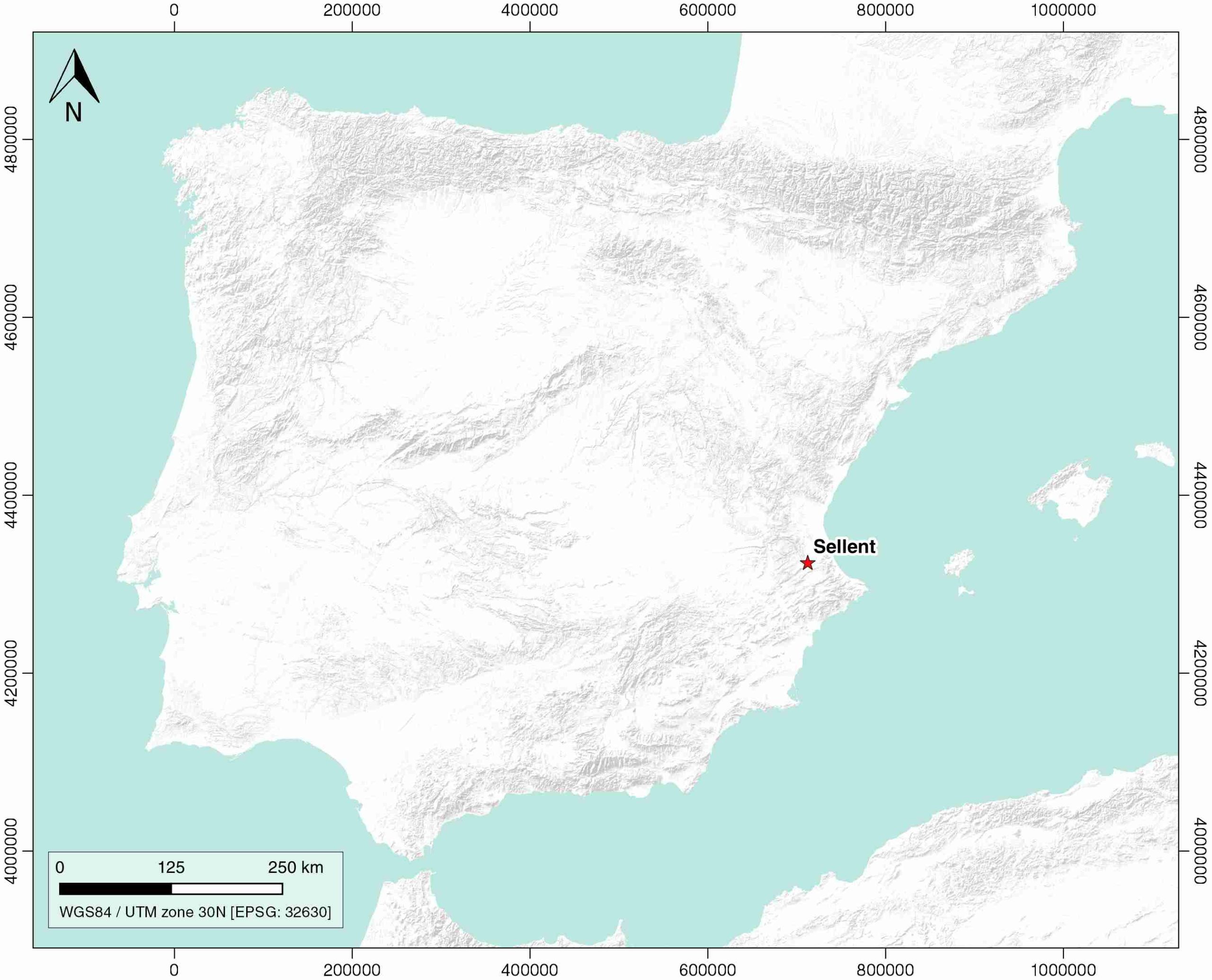
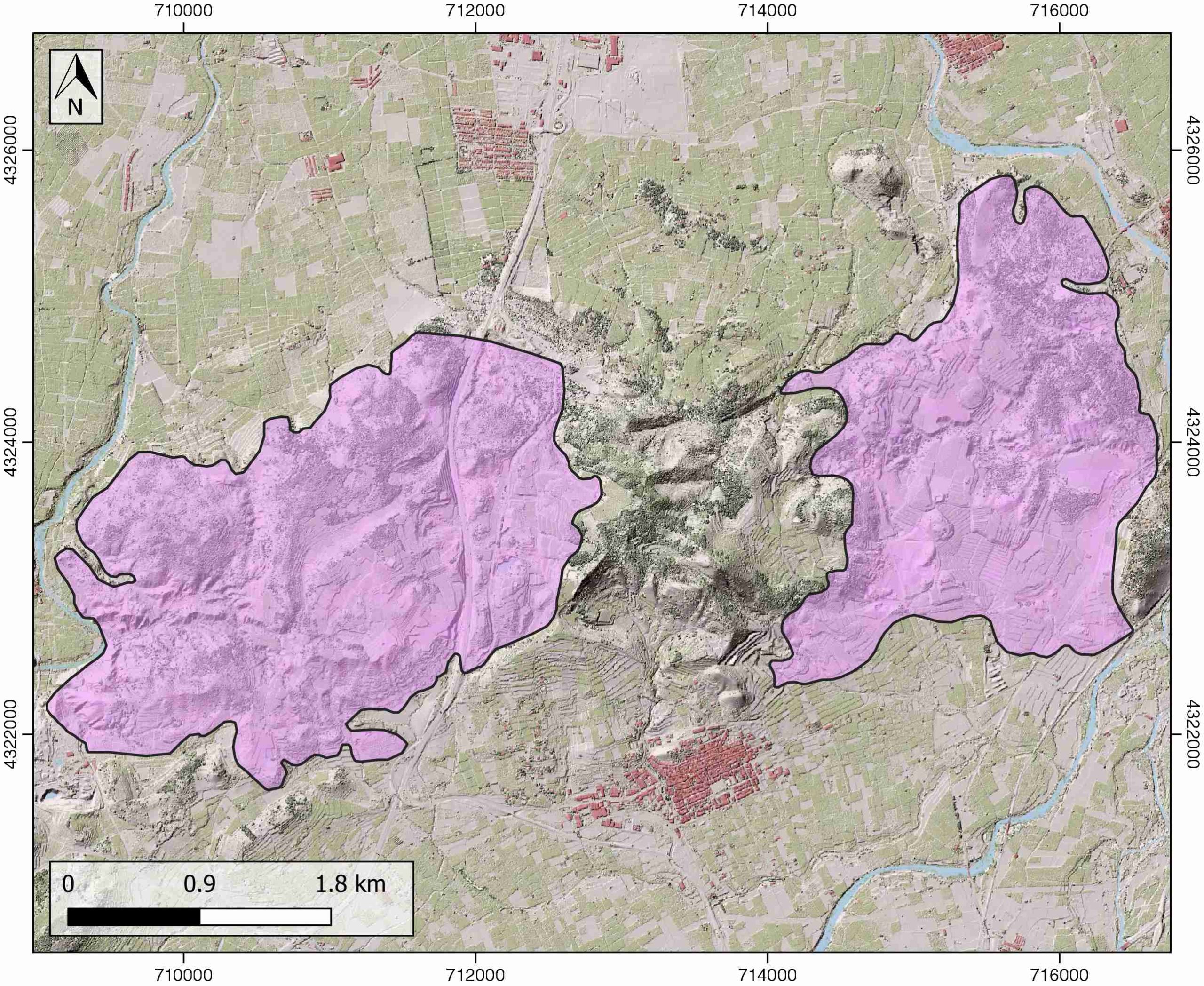
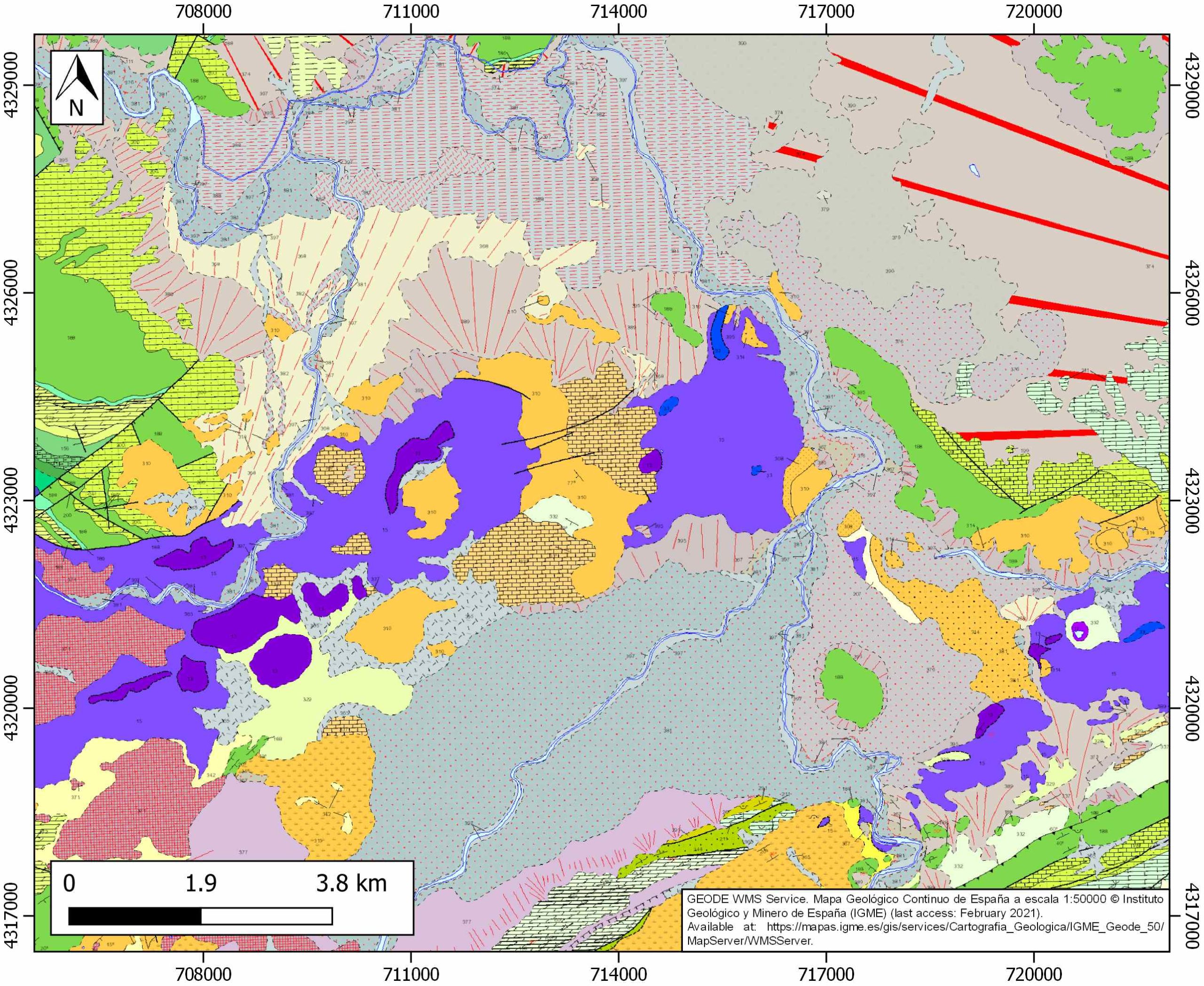
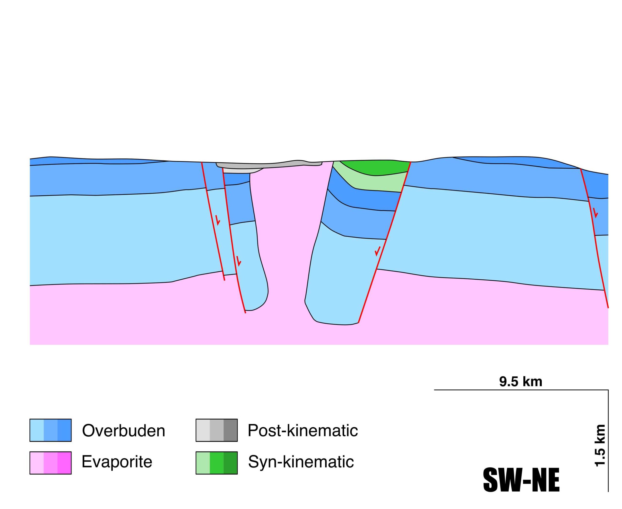
General Information
| Structure type | Evaporite Diapir |
| Deformed/Undeformed | Deformed |
| Geological Setting | Betic system, Pre-Betic cordillera |
| Outcropping/buried | Outcropping |
| Evaporite unit/s name | Jarafuel, Manuel, Cofrentes, Quesa, Ayora and Imón Fms. |
| Evaporite unit/s age | Carnian-Rhaetian (Upper Triassic) |
| Evaporite unit/s origin | Marine |
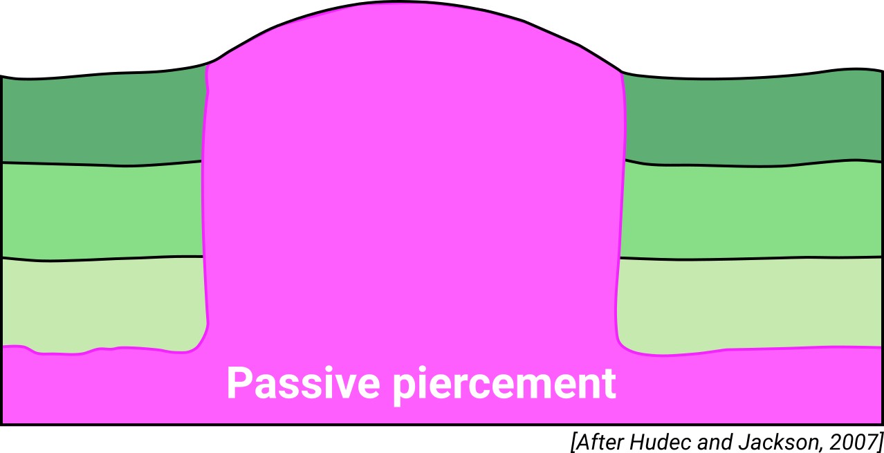
| Classif. (Hudec and Jackson, 2009) | Passive piercement |
| Classif. (Jackson and Talbot, 1986) | Salt wall |
| Age of evaporite flow or deformation (when deformed) | Miocene |
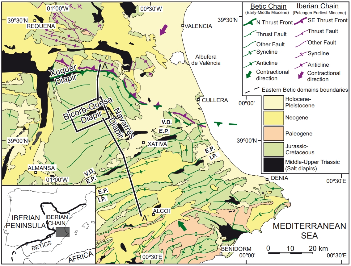
| Other comments | Bicorp-Quesa, Navarrés and Sellent salt wall segments constitute a continuous kinked salt wall of Middle to Upper Triassic evaporites, that crosses the central part of the Valencian domain. Salt wall development was preceded by a contractional deformation that folded and thrusted the Middle-Upper Triassic successions. |
Generic Data
| Unique ID | 51 |
| Name | Sellent |
| Structure type | Evaporite diapir |
| Deformed/Undeformed | Deformed |
| Buried/Outcropping | Outcropping |
| Geological setting | Betic System |
| Geological Regional Setting | Pre-Betic Cordillera (Valencian domain) |
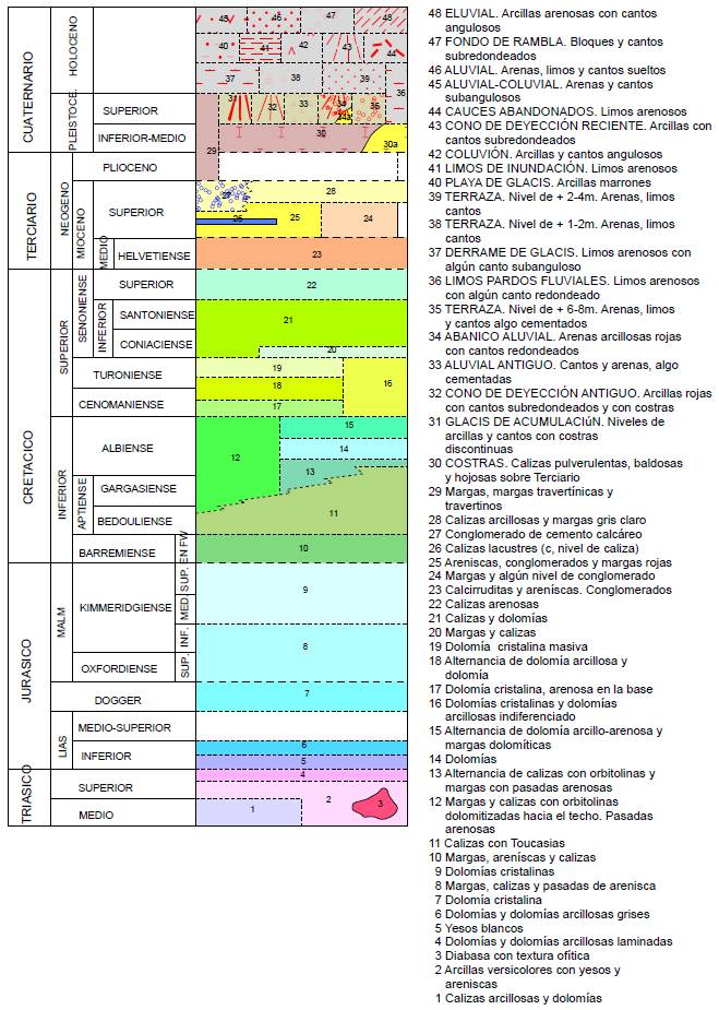
| Evaporite unit/s name | Jarafuel, Manuel, Cofrentes, Quesa, Ayora and Imón Fms. |
| Evaporite unit/s age | Carnian-Rhaetian (Upper Triassic) |
| Evaporite unit/s era | Mesozoic |
| Evaporite unit/s origin | Marine |
| Evaporite unit/s composition | Gypsum-Mudstone-Dolostone-Sandstone |
| Post-kinematic unit/s (or post-evaporite units when evaporites are undeformed) | Quaternary (alluvial and colluvial detrital deposits) |
| Post-kinematic unit/s age (or post-evaporite units when evaporites are undeformed) | Pleistocene-Holocene |
| Classification (Hudec and Jackson, 2009) | Passive piercement |
| Classification (Jackson and Talbot, 1986) | Salt wall |
| Mining activity? | Y |
| Mining activity start | – |
| Mining activity end | – |
| Mining galleries? | – |
| Mining products | Limestone (other uses) |
| Mining sub-products | – |
| Evaporite flow? | Y |
| Age of evaporite flow | Miocene |
| Flow or deformation triggering mechanisms | Late Miocene thin-skinned extensional fault system |
| Flow-linked structures? | Y |
| Halokinetic structures | Normal high-angle faults / joints / thickness variations / progressive unconformities |
| Post-evaporite and pre-kinematic unit/s (overbuden) | Jurassic (anhydrite, calcarenite, dolostones, marly limestones) ; Early Cretaceous (sandstones, dolostones, calcarenites) ; Late Cretaceous (sandstones, dolostones, marly dolostones, limestones) |
| Syn-kinematic unit/s | Miocene (red and grey mudstones, sandstones, limestones, conglomerates) |
| Available seismic profiles | |
| Available boreholes | BARRANCO BONO / ALTOS RIEGOS / CAMINO DEL PINAR / PEDRERA-2 / PEDRERA / RINCON DE COTES / PLA |
| Additional comments | Bicorp-Quesa, Navarrés and Sellent salt wall segments constitute a continuous kinked salt wall of Middle to Upper Triassic evaporites, that crosses the central part of the Valencian domain. Salt wall development was preceded by a contractional deformation that folded and thrusted the Middle-Upper Triassic successions. |
Mining Data
| UNIQUE_ID | 51 |
| Minning exploitations within <2km? | Y |
| Historical/Active | Active |
| Exploitation name #1 | TOSSAL NEGRE |
| Exploitation ID (Spanish National Mining Cadastre) #1 | 855 |
| Municipality #1 | Sellent |
| Province #1 | VALENCIA |
| Company #1 | AGLOMERADOS LOS SERRANOS S.A |
| Main minning Products #1 | Limestone (other uses) |
| Exploitation name #2 | |
| Exploitation ID (Spanish National Mining Cadastre) #2 | |
| Municipality #2 | |
| Province #2 | |
| Company #2 | |
| Main minning Products #2 | |
| Exploitation name #3 | |
| Exploitation ID (Spanish National Mining Cadastre) #3 | |
| Municipality #3 | |
| Province #3 | |
| Company #3 | |
| Main minning Products #3 |
Quantitative Data
| UNIQUE_ID | 51 |
| Outcropping area (km2) | 12.64867 |
| Horizontal intersection area (km2) (when buried) | Not buried |
| Depth of intersection area (km2) (when buried) | Not buried |
| Max. Width (Km) | 3.33988943 |
| Max. Length (Km) | 7.80730861 |
| Max. Evaporites thickness (km) | 1.2 |
| Max. Deformation age (Ma) | 23 |
| Min. Deformation age (Ma) | 6 |
| Deformation stages | 1 |
Reference Data
| UNIQUE_ID | 51 |
| Section source | IGME MAGNA 50. SHEET 769 (NAVARRÉS) |
| Well / Borehole availability #1 | n.a. |
| Well / Borehole availability #2 | n.a. |
| Available data (Stratigraphy) #1 | Gutiérrez, F., Sevil, J., Silva, P. G., Roca, E., Escosa, F., 2019. Geomorphic and stratigraphic evidence of Quaternary diapiric activity enhanced by fluvial incision. Navarrés salt wall and graben system, SE Spain. Geomorphology, 342, 176-195. [link] |
| Available data (Stratigraphy) #2 | Anadón, P., Robles, F., Roca, E., Utrilla, R., Vázquez, A., 1998. Lacustrine sedimentation in the diapir-controlled Miocene Bicorb Basin, eastern Spain. Palaeogeography, Palaeoclimatology, Palaeoecology, 140(1-4), 217-243. [link] |
| Available data (Stratigraphy) #3 | Rubinat-Cabanas, M., 2012. Basement fault influence on the Bicorb-Quesa Salt Wall kinematics, insights from Magnetotelluric and Paleomagnetic techniques on Salt Tectonics [Ph.D. thesis]: Universitat de Barcelona, Barcelona, 169pp. [link] |
| Available data (Stratigraphy) #4 | Roca, E., Beamud, E., Rubinat, M., Soto, R., Ferrer, O., 2013. Paleomagnetic and inner diapiric structural constraints on the kinematic evolution of a salt-wall: The Bicorb-Quesa and northern Navarrés salt-wall segments case (Prebetic Zone, SE Iberia). Journal of Structural Geology, 52, 80-95. [link] |
| Available data (Stratigraphy) #5 | Navarro-Carrasco, Ó., Meléndez-Hevia, I., 2020. Geology and evolution of the Cortes de Pallás diapir (Eastern Iberia). Journal of Maps, 16(2), 625-637. [link] |
| Available data (Stratigraphy) #6 | López-Gómez, J., Alonso-Azcárate, J., Arche, A., Arribas, J., Barrenechea, J. F., Borruel-Abadía, V., Bourquin, S., Cadenas, P., Cuevas, J., De La Horra, R., Bienvenido, J., Escudero-Mozo, M.J., Fernández-Viejo, G. (…) & Díez, J. B., 2019. Permian-Triassic Rifting Stage. In: Quesada C., Oliveira J. (eds) The Geology of Iberia: A Geodynamic Approach. Regional Geology Reviews. Springer, Cham. [link] |
| Regional Stratigraphy | IGME MAGNA50 SHEET (769-Navarrés). [link] |
| Seismic data availability #1 | n.a. |
| Seismic data availability #2 | n.a. |
| Seismic data availability #3 | n.a. |
| Available data (Structure) #1 | Roca, E., Beamud, E., Rubinat, M., Soto, R., Ferrer, O., 2013. Paleomagnetic and inner diapiric structural constraints on the kinematic evolution of a salt-wall: The Bicorb-Quesa and northern Navarrés salt-wall segments case (Prebetic Zone, SE Iberia). Journal of Structural Geology, 52, 80-95. [link] |
| Available data (Structure) #2 | Rubinat-Cabanas, M., 2012. Basement fault influence on the Bicorb-Quesa Salt Wall kinematics, insights from Magnetotelluric and Paleomagnetic techniques on Salt Tectonics [Ph.D. thesis]: Universitat de Barcelona, Barcelona, 169pp. [link] |
| Available data (Structure) #3 | Arche, A., López-Gómez, J., García-Hidalgo, J. F., 2002. Control climático, tectónico y eustático en depósitos del Carniense (Triásico Superior) del SE de la Península Ibérica. Journal of Iberian Geology, 28, 13-30. [link] |
| Available data (Structure) #4 | Gutiérrez, F., Sevil, J., Silva, P. G., Roca, E., Escosa, F., 2019. Geomorphic and stratigraphic evidence of Quaternary diapiric activity enhanced by fluvial incision. Navarrés salt wall and graben system, SE Spain. Geomorphology, 342, 176-195. [link] |
| Available data (Structure) #5 | Santisteban, C. D., Saiz, J., Ruiz Sánchez, F. J., Bello, D, 1990. Tectónica y sedimentación en el margen oeste del «rift» terciario del valle de Ayora-Cofrentes (Valencia). Geogaceta, 8, 44-47. [link] |
| Available data (Structure) #6 | Silva, P. G., Giner-Robles, J. L., Elez, J., Rodríguez-Pascua, M. A., Perucha, M. A., Roquero, E., (…), Martínez-Graña, A., 2015. Tectonic geomorphology and volcanism in the Ayora-Cofrentes tectonic corridor, Valencia (Prebetic, SE Spain). XIV Reunión Nacional de Cuaternario, Granada, 162-166. [link] |
| Available data (Analogue modelling) #1 | n.a. |
| Available data (Analogue modelling) #2 | n.a. |
| Available data (Analogue modelling) #3 | n.a. |
| Available data (Gravimetry – Tomography) #1 | Rubinat-Cabanas, M., 2012. Basement fault influence on the Bicorb-Quesa Salt Wall kinematics, insights from Magnetotelluric and Paleomagnetic techniques on Salt Tectonics [Ph.D. thesis]: Universitat de Barcelona, Barcelona, 169pp. [link] |
| Available data (Gravimetry – Tomography) #2 | Castaño-Fernández, S., Carbó-Gorosabel, A., 1995. Los afloramientos triásicos de la zona de confluencia de las Cordilleras Ibérica y Bética. Aportes de la gravimetría a su interpretación. Cuadernos de geología ibérica, (19), 235-248. [link] |
| Available data (Gravimetry – Tomography) #3 | Ayala, C., Bohoyo, F., Maestro, A., Reguera, M. I., Torne, M., Rubio, F., Fernández, M., García-Lobón, J. L., 2016. Updated Bouguer anomalies of the Iberian Peninsula: a new perspective to interpret the regional geology. Journal of Maps, 12(5), 1089-1092. [link] |
| Available data (Geochemistry) #1 | Ortí, F., García-Veigas, J., Rossell, L., Jurado, M. J., Utrilla, R., 1996. Formaciones salinas de las cuencas triásicas en la Península Ibérica: Caracterización Petrológica y Geoquímica. Cuadernos de Geología Ibérica, 20, 13-35. [link] |
| Available data (Geochemistry) #2 | n.a. |
| Available data (Geochemistry) #3 | n.a. |
| Available data (Geochemistry) #4 | n.a. |
| Available data (Petrophysics) #1 | Soto, R., Beamud, E., Oliva-Urcia, B., Roca, E., Rubinat, M., Villalaín, J. J., 2014. Applicability of magnetic fabrics in rocks associated with the emplacement of salt structures (the Bicorb–Quesa and Navarrés salt walls, Prebetics, SE Spain). Tectonophysics, 629, 319-334. [link] |
| Available data (Petrophysics) #2 | Roca, E., Beamud, E., Rubinat, M., Soto, R., Ferrer, O., 2013. Paleomagnetic and inner diapiric structural constraints on the kinematic evolution of a salt-wall: The Bicorb-Quesa and northern Navarrés salt-wall segments case (Prebetic Zone, SE Iberia). Journal of Structural Geology, 52, 80-95. [link] |
| IGME Geological Map (MAGNA50) Sheet number | 769-Navarres. [link] |
| Other Maps #1 (source) | Escosa, F. O., Ferrer, O., Roca, E., 2018. Geology of the Eastern Prebetic Zone at the Jumilla region (SE Iberia). Journal of Maps, 14(2), 77-86. [link] |
| Other Maps #2 (source) | Rubinat-Cabanas, M., 2012. Basement fault influence on the Bicorb-Quesa Salt Wall kinematics, insights from Magnetotelluric and Paleomagnetic techniques on Salt Tectonics [Ph.D. thesis]: Universitat de Barcelona, Barcelona, 169pp. [link] |
| Other related references #1 | Santisteban, C., Ruíz-Sánchez, F., Bello, D., 1989. Los depósitos lacustres del Terciario de Bicorp (Valencia). Acta geológica hispánica, 24(3), 299-307. [link] |
| Other related references #2 | Ortí-Cabo, F., 1974. El Keuper del Levante español. Estudios Geológicos, 30. [link] |
| Other related references #3 | n.a. |
| Other related references #4 | n.a. |
Well and Seismic Data
| UNIQUE_ID | 51 |
| Seismic survey name #1 | |
| Across structure? #1 | |
| Seismic profile ID (IGME) #1 | |
| Seismic profile code #1 | |
| Seismic profile name #1 | |
| Seismic survey year #1 | |
| Data repository #1 | |
| Length (km) #1 | |
| Seismic survey name #2 | |
| Across structure? #2 | |
| Seismic profile ID (IGME) #2 | |
| Seismic profile code #2 | |
| Seismic profile name #2 | |
| Seismic survey year #2 | |
| Data repository #2 | |
| Length (km) #2 | |
| Seismic survey name #3 | |
| Across structure? #3 | |
| Seismic profile ID (IGME) #3 | |
| Seismic profile code #3 | |
| Seismic profile name #3 | |
| Seismic survey year #3 | |
| Data repository #3 | |
| Length (km) #3 | |
| Seismic survey name #4 | |
| Across structure? #4 | |
| Seismic profile ID (IGME) #4 | |
| Seismic profile code #4 | |
| Seismic profile name #4 | |
| Seismic survey year #4 | |
| Data repository #4 | |
| Length (km) #4 | |
| Seismic survey name #5 | |
| Across structure? #5 | |
| Seismic profile ID (IGME) #5 | |
| Seismic profile code #5 | |
| Seismic profile name #5 | |
| Seismic survey year #5 | |
| Data repository #5 | |
| Length (km) #5 | |
| Seismic survey name #6 | |
| Across structure? #6 | |
| Seismic profile ID (IGME) #6 | |
| Seismic profile code #6 | |
| Seismic profile name #6 | |
| Seismic survey year #6 | |
| Data repository #6 | |
| Length (km) #6 | |
| Seismic survey name #7 | |
| Across structure? #7 | |
| Seismic profile ID (IGME) #7 | |
| Seismic profile code #7 | |
| Seismic profile name #7 | |
| Seismic survey year #7 | |
| Data repository #7 | |
| Length (km) #7 | |
| Seismic survey name #8 | |
| Across structure? #8 | |
| Seismic profile ID (IGME) #8 | |
| Seismic profile code #8 | |
| Seismic profile name #8 | |
| Seismic survey year #8 | |
| Data repository #8 | |
| Length (km) #8 | |
| Seismic survey name #9 | |
| Across structure? #9 | |
| Seismic profile ID (IGME) #9 | |
| Seismic profile code #9 | |
| Seismic profile name #9 | |
| Seismic survey year #9 | |
| Data repository #9 | |
| Length (km) #9 | |
| Seismic survey name #10 | |
| Across structure? #10 | |
| Seismic profile ID (IGME) #10 | |
| Seismic profile code #10 | |
| Seismic profile name #10 | |
| Seismic survey year #10 | |
| Data repository #10 | |
| Length (km) #10 | |
| Seismic survey name #11 | |
| Across structure? #11 | |
| Seismic profile ID (IGME) #11 | |
| Seismic profile code #11 | |
| Seismic profile name #11 | |
| Seismic survey year #11 | |
| Data repository #11 | |
| Length (km) #11 | |
| Seismic survey name #12 | |
| Across structure? #12 | |
| Seismic profile ID (IGME) #12 | |
| Seismic profile code #12 | |
| Seismic profile name #12 | |
| Seismic survey year #12 | |
| Data repository #12 | |
| Length (km) #12 | |
| Seismic survey name #13 | |
| Across structure? #13 | |
| Seismic profile ID (IGME) #13 | |
| Seismic profile code #13 | |
| Seismic profile name #13 | |
| Seismic survey year #13 | |
| Data repository #13 | |
| Length (km) #13 | |
| Seismic survey name #14 | |
| Across structure? #14 | |
| Seismic profile ID (IGME) #14 | |
| Seismic profile code #14 | |
| Seismic profile name #14 | |
| Seismic survey year #14 | |
| Data repository #14 | |
| Length (km) #14 | |
| Seismic survey name #15 | |
| Across structure? #15 | |
| Seismic profile ID (IGME) #15 | |
| Seismic profile code #15 | |
| Seismic profile name #15 | |
| Seismic survey year #15 | |
| Data repository #15 | |
| Length (km) #15 | |
| Seismic survey name #16 | |
| Across structure? #16 | |
| Seismic profile ID (IGME) #16 | |
| Seismic profile code #16 | |
| Seismic profile name #16 | |
| Seismic survey year #16 | |
| Data repository #16 | |
| Length (km) #16 | |
| Seismic survey name #17 | |
| Across structure? #17 | |
| Seismic profile ID (IGME) #17 | |
| Seismic profile code #17 | |
| Seismic profile name #17 | |
| Seismic survey year #17 | |
| Data repository #17 | |
| Length (km) #17 | |
| Seismic survey name #18 | |
| Across structure? #18 | |
| Seismic profile ID (IGME) #18 | |
| Seismic profile code #18 | |
| Seismic profile name #18 | |
| Seismic survey year #18 | |
| Data repository #18 | |
| Length (km) #18 | |
| Seismic survey name #19 | |
| Across structure? #19 | |
| Seismic profile ID (IGME) #19 | |
| Seismic profile code #19 | |
| Seismic profile name #19 | |
| Seismic survey year #19 | |
| Data repository #19 | |
| Length (km) #19 | |
| Seismic survey name #20 | |
| Across structure? #20 | |
| Seismic profile ID (IGME) #20 | |
| Seismic profile code #20 | |
| Seismic profile name #20 | |
| Seismic survey year #20 | |
| Data repository #20 | |
| Length (km) #20 | |
| Seismic survey name #21 | |
| Across structure? #21 | |
| Seismic profile ID (IGME) #21 | |
| Seismic profile code #21 | |
| Seismic profile name #21 | |
| Seismic survey year #21 | |
| Data repository #21 | |
| Length (km) #21 | |
| Borehole name #1 | BARRANCO BONO |
| Company #1 | TRAGSA |
| Traget #1 | HYDROGEOLOGY |
| Across structure? #1 | N (within 5 km) |
| Borehole name #2 | ALTOS RIEGOS |
| Company #2 | TRAGSA |
| Traget #2 | HYDROGEOLOGY |
| Across structure? #2 | N (within 5 km) |
| Borehole name #3 | CAMINO DEL PINAR |
| Company #3 | TRAGSA |
| Traget #3 | HYDROGEOLOGY |
| Across structure? #3 | N (within 5 km) |
| Borehole name #4 | PEDRERA-2 |
| Company #4 | TRAGSA |
| Traget #4 | HYDROGEOLOGY |
| Across structure? #4 | N (within 5 km) |
| Borehole name #5 | PEDRERA |
| Company #5 | TRAGSA |
| Traget #5 | HYDROGEOLOGY |
| Across structure? #5 | N (within 5 km) |
| Borehole name #6 | RINCON DE COTES |
| Company #6 | TRAGSA |
| Traget #6 | HYDROGEOLOGY |
| Across structure? #6 | N (within 5 km) |
| Borehole name #7 | PLA |
| Company #7 | TRAGSA |
| Traget #7 | HYDROGEOLOGY |
| Across structure? #7 | N (within 5 km) |
| Borehole name #8 | |
| Company #8 | |
| Traget #8 | |
| Across structure? #8 | |
| Borehole name #9 | |
| Company #9 | |
| Traget #9 | |
| Across structure? #9 | |
| Borehole name #10 | |
| Company #10 | |
| Traget #10 | |
| Across structure? #10 | |
| Borehole name #11 | |
| Company #11 | |
| Traget #11 | |
| Across structure? #11 | |
| Borehole name #12 | |
| Company #12 | |
| Traget #12 | |
| Across structure? #12 | |
| Borehole name #13 | |
| Company #13 | |
| Traget #13 | |
| Across structure? #13 | |
| Borehole name #14 | |
| Company #14 | |
| Traget #14 | |
| Across structure? #14 | |
| Borehole name #15 | |
| Company #15 | |
| Traget #15 | |
| Across structure? #15 |
Geographical Data (EPSG:4326 - WGS 84)
| UNIQUE_ID | 51 |
| X Centroid (Structure shape) | -0.540126 |
| Y Centroid (Structure shape) | -0.540126 |
| Xmin (Structure shape) | -0.584975 |
| Xmax (Structure shape) | -0.496606 |
| Ymin (Structure shape) | 39.018247 |
| Ymax (Structure shape) | 39.054905 |
| Xmin seismic line #1 | |
| Xmax seismic line #1 | |
| Ymin seismic line #1 | |
| Ymax seismic line #1 | |
| Xmin seismic line #2 | |
| Xmax seismic line #2 | |
| Ymin seismic line #2 | |
| Ymax seismic line #2 | |
| Xmin seismic line #3 | |
| Xmax seismic line #3 | |
| Ymin seismic line #3 | |
| Ymax seismic line #3 | |
| Xmin seismic line #4 | |
| Xmax seismic line #4 | |
| Ymin seismic line #4 | |
| Ymax seismic line #4 | |
| Xmin seismic line #5 | |
| Xmax seismic line #5 | |
| Ymin seismic line #5 | |
| Ymax seismic line #5 | |
| Xmin seismic line #6 | |
| Xmax seismic line #6 | |
| Ymin seismic line #6 | |
| Ymax seismic line #6 | |
| Xmin seismic line #7 | |
| Xmax seismic line #7 | |
| Ymin seismic line #7 | |
| Ymax seismic line #7 | |
| Xmin seismic line #8 | |
| Xmax seismic line #8 | |
| Ymin seismic line #8 | |
| Ymax seismic line #8 | |
| Xmin seismic line #9 | |
| Xmax seismic line #9 | |
| Ymin seismic line #9 | |
| Ymax seismic line #9 | |
| Xmin seismic line #10 | |
| Xmax seismic line #10 | |
| Ymin seismic line #10 | |
| Ymax seismic line #10 | |
| Xmin seismic line #11 | |
| Xmax seismic line #11 | |
| Ymin seismic line #11 | |
| Ymax seismic line #11 | |
| Xmin seismic line #12 | |
| Xmax seismic line #12 | |
| Ymin seismic line #12 | |
| Ymax seismic line #12 | |
| Xmin seismic line #13 | |
| Xmax seismic line #13 | |
| Ymin seismic line #13 | |
| Ymax seismic line #13 | |
| Xmin seismic line #14 | |
| Xmax seismic line #14 | |
| Ymin seismic line #14 | |
| Ymax seismic line #14 | |
| Xmin seismic line #15 | |
| Xmax seismic line #15 | |
| Ymin seismic line #15 | |
| Ymax seismic line #15 | |
| Xmin seismic line #16 | |
| Xmax seismic line #16 | |
| Ymin seismic line #16 | |
| Ymax seismic line #16 | |
| Xmin seismic line #17 | |
| Xmax seismic line #17 | |
| Ymin seismic line #17 | |
| Ymax seismic line #17 | |
| Xmin seismic line #18 | |
| Xmax seismic line #18 | |
| Ymin seismic line #18 | |
| Ymax seismic line #18 | |
| Xmin seismic line #19 | |
| Xmax seismic line #19 | |
| Ymin seismic line #19 | |
| Ymax seismic line #19 | |
| Xmin seismic line #20 | |
| Xmax seismic line #20 | |
| Ymin seismic line #20 | |
| Ymax seismic line #20 | |
| Xmin seismic line #21 | |
| Xmax seismic line #21 | |
| Ymin seismic line #21 | |
| Ymax seismic line #21 | |
| X borehole #1 | -0.589088 |
| Y borehole #1 | 39.046924 |
| X borehole #2 | -0.532348 |
| Y borehole #2 | 39.053845 |
| X borehole #3 | -0.560243 |
| Y borehole #3 | 39.051468 |
| X borehole #4 | -0.578212 |
| Y borehole #4 | 39.063592 |
| X borehole #5 | -0.578212 |
| Y borehole #5 | 39.063592 |
| X borehole #6 | -0.595708 |
| Y borehole #6 | 39.060548 |
| X borehole #7 | -0.526565 |
| Y borehole #7 | 39.067237 |
| X borehole #8 | |
| Y borehole #8 | |
| X borehole #9 | |
| Y borehole #9 | |
| X borehole #10 | |
| Y borehole #10 | |
| X borehole #11 | |
| Y borehole #11 | |
| X borehole #12 | |
| Y borehole #12 | |
| X borehole #13 | |
| Y borehole #13 | |
| X borehole #14 | |
| Y borehole #14 | |
| X borehole #15 | |
| Y borehole #15 |

