General Information
| Structure type | Evaporite-cored anticline |
| Deformed/Undeformed | Deformed |
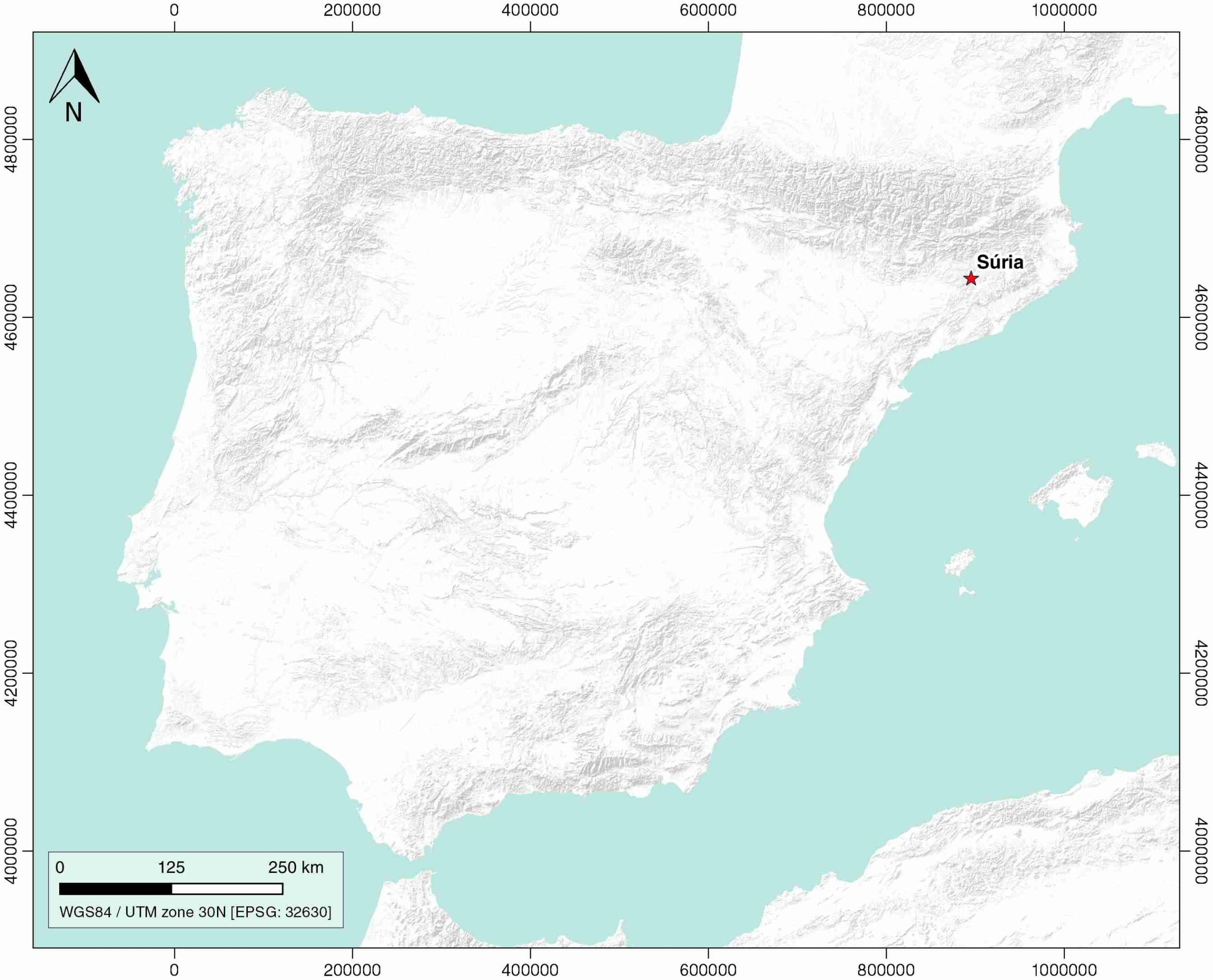
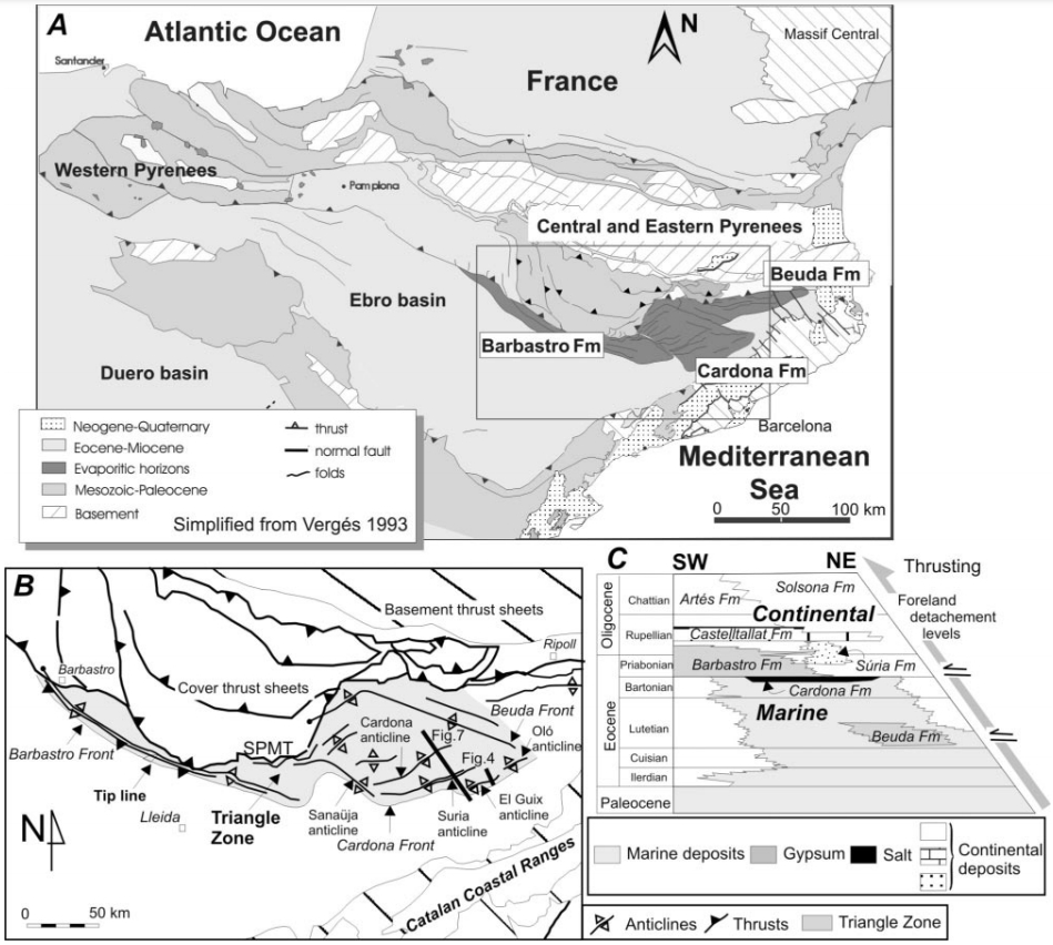
| Geological Setting | Catalan Potash sub-basin, Ebro foreland basin |
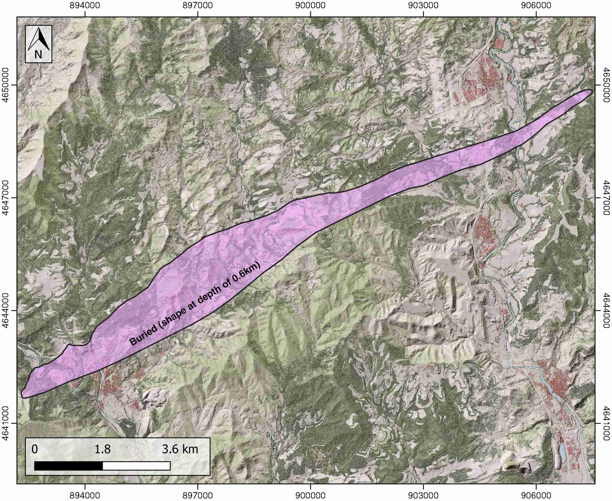
| Outcropping/buried | Buried |
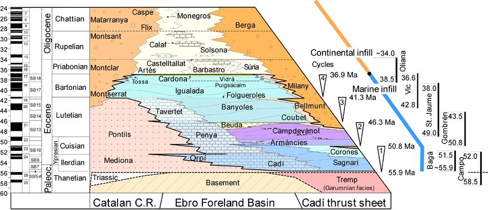
| Evaporite unit/s name | Cardona Fm. |
| Evaporite unit/s age | Priabonian (Eocene) |
| Evaporite unit/s origin | Marine |
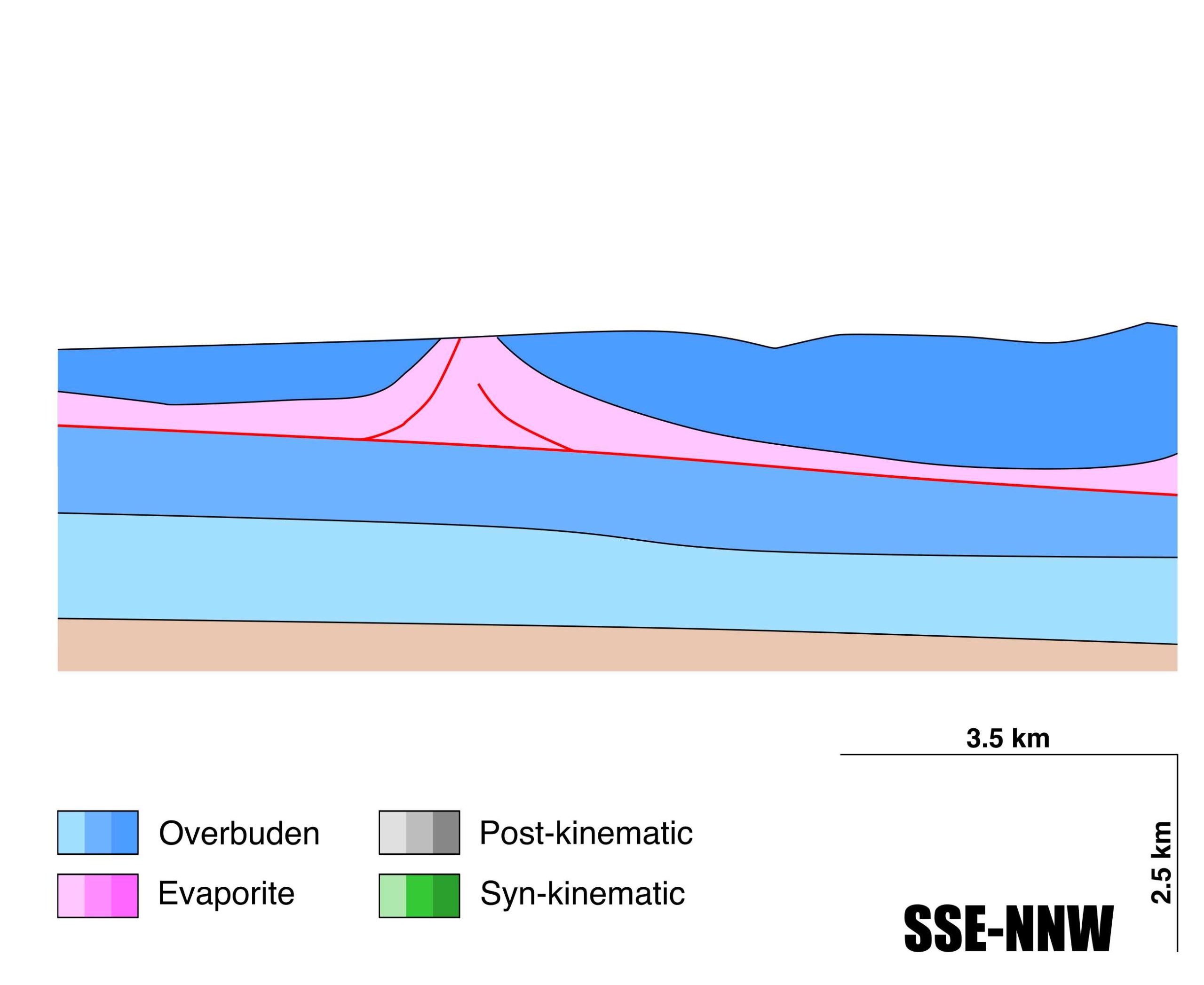
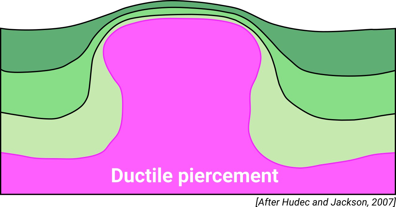
| Classif. (Hudec and Jackson, 2009) | Ductile piercement |
| Classif. (Jackson and Talbot, 1986) | Salt anticline |
| Age of evaporite flow or deformation (when deformed) | Lower Oligocene, Quaternary / Active now(?) |
| Other comments | Unprecise growth age of the Cardona, Suria and El Guix anticlines because of the absence of related syntectonic sediments. |
Generic Data
| Unique ID | 106 |
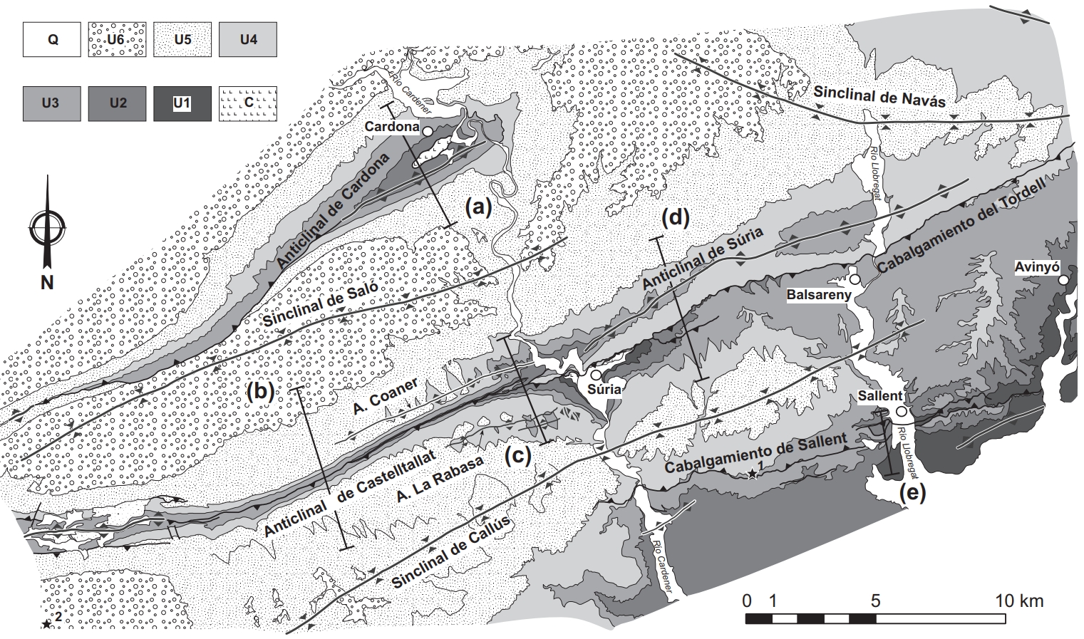
| Name | Súria |
| Structure type | Evaporite-cored anticline |
| Deformed/Undeformed | Deformed |
| Buried/Outcropping | Buried |
| Geological setting | Ebro Basin |
| Geological Regional Setting | Catalan Potash sub-basin |
| Evaporite unit/s name | Cardona Fm. |
| Evaporite unit/s age | Priabonian (Eocene) |
| Evaporite unit/s era | Cenozoic |
| Evaporite unit/s origin | Marine |
| Evaporite unit/s composition | Halite-Anhydrite-Carnallite-Sylvite-Shale-Marlstones |
| Post-kinematic unit/s (or post-evaporite units when evaporites are undeformed) | Quaternary (alluvial and colluvial detrital deposits) |
| Post-kinematic unit/s age (or post-evaporite units when evaporites are undeformed) | Pleistocene-Holocene |
| Classification (Hudec and Jackson, 2009) | Ductile piercement |
| Classification (Jackson and Talbot, 1986) | Salt anticline |
| Mining activity? | Y |
| Mining activity start | Roman Empire |
| Mining activity end | Active |
| Mining galleries? | Y |
| Mining products | Potassium salt |
| Mining sub-products | Halite |
| Evaporite flow? | Y |
| Age of evaporite flow | Lower Oligocene (early stage) ; Quaternary (reactivation stage) |
| Flow or deformation triggering mechanisms | Moderate folding of the overlying units and thrusting (Tordell thrust, early stage) ; Quaternary fault activity (reactivation stage) |
| Flow-linked structures? | Y |
| Halokinetic structures | Triangle zone development / thrust faults |
| Post-evaporite and pre-kinematic unit/s (overbuden) | Oligocene (Barbastro and Súria Fms., marlstones, sandstones and shales) ; Oligocene (Castelltallat Fm., limestones, marly limestones, marlstones) ; Upper Oligocene (Solsona Fm., sandstones, red clays, microconglomerates) |
| Syn-kinematic unit/s | – |
| Available seismic profiles | 33 / 8 / 33 / 35 / 60 / K-3 / K-6 / 55-1 / 8 |
| Available boreholes | Llardella / Marbà / Alberto shaft / Cardona |
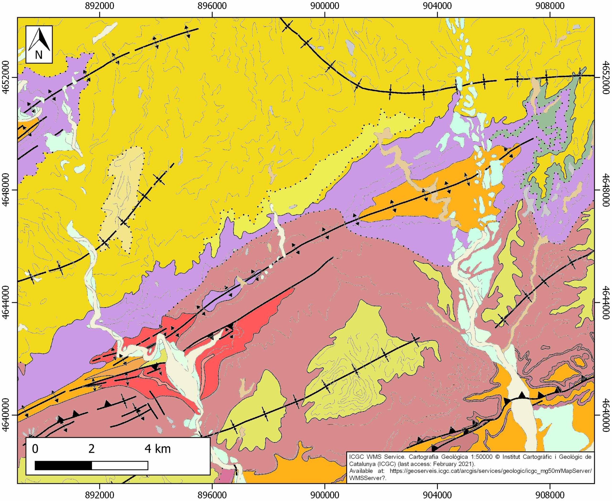
| Additional comments | Unprecise growth age of the Cardona, Suria and El Guix anticlines because of the absence of related syntectonic sediments. Surface geology suggests that the Súria Anticline seems to be a rather simple anticline with a back thrust at its southern limb, but subsurface data indicate that the deeper section is characterized by several north- and south-directed thrusts (see Carola et al., 2017). |
Mining Data
| UNIQUE_ID | 106 |
| Minning exploitations within <2km? | Y |
| Historical/Active | Active |
| Exploitation name #1 | ROMANIA Y OTROS |
| Exploitation ID (Spanish National Mining Cadastre) #1 | 1761 |
| Municipality #1 | Súria |
| Province #1 | BARCELONA |
| Company #1 | IBERPOTASH, SA (CENTRO SALLENT/SURIA) |
| Main minning Products #1 | Potassium salt |
| Exploitation name #2 | |
| Exploitation ID (Spanish National Mining Cadastre) #2 | |
| Municipality #2 | |
| Province #2 | |
| Company #2 | |
| Main minning Products #2 | |
| Exploitation name #3 | |
| Exploitation ID (Spanish National Mining Cadastre) #3 | |
| Municipality #3 | |
| Province #3 | |
| Company #3 | |
| Main minning Products #3 |
Quantitative Data
| UNIQUE_ID | 106 |
| Outcropping area (km2) | Buried |
| Horizontal intersection area (km2) (when buried) | 15.15488 |
| Depth of intersection area (km2) (when buried) | 0.6 |
| Max. Width (Km) | 3.19287356 |
| Max. Length (Km) | 17.0280527 |
| Max. Evaporites thickness (km) | 1.2 |
| Max. Deformation age (Ma) | 32 |
| Min. Deformation age (Ma) | Active |
| Deformation stages | 2 |
Reference Data
| UNIQUE_ID | 106 |
| Section source | Carola, E., Ferrer, O., Vidal-Royo, O., Muñoz, J. A., 2017. Interpretation of salt-cored frontal structures in the Southern Pyrenees guided by analog modeling, surface and subsurface data. Interpretation, 5(1), SD39-SD54. [link] |
| Well / Borehole availability #1 | Private access |
| Well / Borehole availability #2 | Private access |
| Available data (Stratigraphy) #1 | Del Santo, G., García-Sansegundo, J., Sarasa, L., Torrebadella, J., 2000. Estratigrafía y estructura del Terciario en el sector oriental de la cuenca del Ebro entre Solsona y Manresa (NE de España). Revista de la Sociedad Geológica de España, 13(2), 265-278. [link] |
| Available data (Stratigraphy) #2 | Vergés, J., Burbank, D., 1996. Eocene-Oligocene thrusting and basin configuration in the eastern and central Pyrenees (Spain). In P. Friend & C. Dabrio (Eds.), Tertiary Basins of Spain: The Stratigraphic Record of Crustal Kinematics (World and Regional Geology, pp. 120-133). Cambridge: Cambridge University Press. [link] |
| Available data (Stratigraphy) #3 | Burbank, D. W., Puigdefàbregas, C. A. I., and Munoz, J. A., 1992. The chronology of the Eocene tectonic and stratigraphic development of the eastern Pyrenean foreland basin, northeast Spain. Geological Society of America Bulletin, 104(9), 1101-1120. [link] |
| Available data (Stratigraphy) #4 | Sans, M., 2003. From thrust tectonics to diapirism. The role of evaporites in the kinematic evolution of the eastern South Pyrenean front. Geologica Acta, 1(3), 239-260. [link] |
| Available data (Stratigraphy) #5 | Krzywiec P., Vergés J., 2007. Role of the Foredeep Evaporites in Wedge Tectonics and Formation of Triangle Zones: Comparison of the Carpathian and Pyrenean Thrust Fronts. In: Lacombe O., Roure F., Lavé J., Vergés J. (eds) Thrust Belts and Foreland Basins. Frontiers in Earth Sciences. Springer, Berlin, Heidelberg. [link] |
| Available data (Stratigraphy) #6 | Ortega, D., Roqué, C., Ibáñez, J., Beamud, E., Larrasoaña, J. C., Sáez, A., Terradas, X., 2018. The chert from the Castelltallat Formation (south-central Pyrenees): archaeometric characterisation and archaeological implications. Archaeological and Anthropological Sciences, 10(6), 1329-1346. [link] |
| Regional Stratigraphy | Vergés, J., Fernàndez, M., Martìnez, A., 2002. The Pyrenean orogen: pre-, syn-, and post-collisional evolution. Journal of the Virtual Explorer, 8, 55-74. [link] |
| Seismic data availability #1 | n.a. |
| Seismic data availability #2 | n.a. |
| Seismic data availability #3 | n.a. |
| Available data (Structure) #1 | Carola, E., Ferrer, O., Vidal-Royo, O., Muñoz, J. A., 2017. Interpretation of salt-cored frontal structures in the Southern Pyrenees guided by analog modeling, surface and subsurface data. Interpretation, 5(1), SD39-SD54. [link] |
| Available data (Structure) #2 | Del Santo, G., García-Sansegundo, J., Sarasa, L., Torrebadella, J., 2000. Estratigrafía y estructura del Terciario en el sector oriental de la cuenca del Ebro entre Solsona y Manresa (NE de España). Revista de la Sociedad Geológica de España, 13(2), 265-278. [link] |
| Available data (Structure) #3 | Vergés, J., Burbank, D., 1996. Eocene-Oligocene thrusting and basin configuration in the eastern and central Pyrenees (Spain). In P. Friend & C. Dabrio (Eds.), Tertiary Basins of Spain: The Stratigraphic Record of Crustal Kinematics (World and Regional Geology, pp. 120-133). Cambridge: Cambridge University Press. [link] |
| Available data (Structure) #4 | Sans, M., Vergés, J., Gomis, E., Parés, J. M., Schiattarella, M., Travé, A., …, Doulcet, A., 2003. Layer parallel shortening in salt-detached folds: constraint on cross-section restoration. Tectonophysics, 372(1-2), 85-104. [link] |
| Available data (Structure) #5 | Krzywiec P., Vergés J., 2007. Role of the Foredeep Evaporites in Wedge Tectonics and Formation of Triangle Zones: Comparison of the Carpathian and Pyrenean Thrust Fronts. In: Lacombe O., Roure F., Lavé J., Vergés J. (eds) Thrust Belts and Foreland Basins. Frontiers in Earth Sciences. Springer, Berlin, Heidelberg. [link] |
| Available data (Structure) #6 | Miralles, L., and Sans, M., 1996. Fabrica de rocas salinas en una zona de cizalla (anticlinal de Suria, Barcelona). Sociedad Geológica de España, Geogaceta 20-4. [link] |
| Available data (Analogue modelling) #1 | Sans, M., and Koyi, H. A., 2001. Modeling the role of erosion in diapir development in contractional settings. Tectonic Modeling: A Volume in Honor of Hans Ramberg, 111-122. [link] |
| Available data (Analogue modelling) #2 | Sans, M., 2003. From thrust tectonics to diapirism. The role of evaporites in the kinematic evolution of the eastern South Pyrenean front. Geologica Acta, 1(3), 239-260. [link] |
| Available data (Analogue modelling) #3 | Koyi, H. A., and Sans, M., 2006. Deformation transfer in viscous detachments: comparison of sandbox models to the South Pyrenean Triangle Zone. Geological Society, London, Special Publications, 253(1), 117-134. [link] |
| Available data (Gravimetry – Tomography) #1 | Ayala, C., Bohoyo, F., Maestro, A., Reguera, M. I., Torne, M., Rubio, F., Fernández, M., García-Lobón, J. L., 2016. Updated Bouguer anomalies of the Iberian Peninsula: a new perspective to interpret the regional geology. Journal of Maps, 12(5), 1089-1092. [link] |
| Available data (Gravimetry – Tomography) #2 | n.a. |
| Available data (Gravimetry – Tomography) #3 | n.a. |
| Available data (Geochemistry) #1 | Pueyo, J.J., 1975. Estudio petrológico y geoquímico de los yacimientos potásicos de Cardona, Súria, Sallent (Barcelona, España) [Ph.D. thesis]: University of Barcelona, 300pp. [link] |
| Available data (Geochemistry) #2 | Pueyo, J. J. and San Miguel, A., 1971. Características petrológicas de las sales sódicas, potásicas y magnésica de la Cuenca Potásica Catalana». Rev. Inst. Inv. Geol. Dip, Prov. Barcelona, 29, 23-49. [link] |
| Available data (Geochemistry) #3 | Cendón, D. I., Ayora, C., Pueyo, J. J., Taberner, C., 2003. The geochemical evolution of the Catalan potash subbasin, South Pyrenean foreland basin (Spain). Chemical Geology, 200(3-4), 339-357. [link] |
| Available data (Geochemistry) #4 | De Las Cuevas, C., and Pueyo, J. J., 1995. The influence of mineralogy and texture in the water content of rock salt formations. Its implication in radioactive waste disposal. Applied geochemistry, 10(3), 317-327. [link] |
| Available data (Petrophysics) #1 | Miralles, L., Sans, M., Galí, S., Santanach, P., 2001. 3-D rock salt fabrics in a shear zone (Súria Anticline, South-Pyrenees). Journal of Structural Geology, 23(4), 675-691. [link] |
| Available data (Petrophysics) #2 | Parés, J. M., Anastasio, D., 2018. The extent of penetrative Pyrenean deformation in the Ebro foreland Basin: Magnetic fabric data from the eastern sector. Geologica Acta, 16(4), 375-390. [link] |
| IGME Geological Map (MAGNA50) Sheet number | 330-Cardona. [link] and 331-PuigReig. [link] and 362-Calaf. [link] |
| Other Maps #1 (source) | Sans, M., 2003. From thrust tectonics to diapirism. The role of evaporites in the kinematic evolution of the eastern South Pyrenean front. Geologica Acta, 1(3), 239-260. [link] |
| Other Maps #2 (source) | Del Santo, G., García-Sansegundo, J., Sarasa, L., Torrebadella, J., 2000. Estratigrafía y estructura del Terciario en el sector oriental de la cuenca del Ebro entre Solsona y Manresa (NE de España). Revista de la Sociedad Geológica de España, 13(2), 265-278. [link] |
| Other related references #1 | Lanaja, J. M., R. Querol, A. Navarro, 1987. Contribución de la Exploración Petrolífera al Conocimiento de la Geología de España, pp. 1–465, Instituto Geológico y Minero de España, Madrid. [link] |
| Other related references #2 | Rosell i Ortiz, L. and Pueyo Mur, J. J., 1984. Características geoquímicas de la formación de sales potásicas de Navarra (Eoceno superior). Comparación con la cuenca potásica catalana. Acta Geologica Hispanica, 19, 81-95. [link] |
| Other related references #3 | Landrø, M., Puigdefabregas, C., Arntsen, B., 2011. Anisotropy in the salt outcrop at Cardona, Catalonia–implications for seismic imaging. First break, 29(8), 41-44. [link] |
| Other related references #4 | Travé, A., Calvet, F., Sans, M., Vergés, J., Thirlwall, M., 2000. Fluid history related to the Alpine compression at the margin of the south-Pyrenean Foreland basin: the El Guix anticline. Tectonophysics, 321(1), 73-102. [link] |
Well and Seismic Data
| UNIQUE_ID | 106 |
| Seismic survey name #1 | 12D2-33 |
| Across structure? #1 | Y |
| Seismic profile ID (IGME) #1 | 10365 |
| Seismic profile code #1 | 14993 |
| Seismic profile name #1 | 33 |
| Seismic survey year #1 | 1961 |
| Data repository #1 | SIGEOF Data Catalogue (Section available under request). ©Instituto Geológico y Minero de España (IGME). https://info.igme.es/SIGEOF/ |
| Length (km) #1 | 13.42 |
| Seismic survey name #2 | 12D2-8 |
| Across structure? #2 | Y |
| Seismic profile ID (IGME) #2 | 10399 |
| Seismic profile code #2 | 15028 |
| Seismic profile name #2 | 8 |
| Seismic survey year #2 | 1961 |
| Data repository #2 | SIGEOF Data Catalogue (Private access section). ©Instituto Geológico y Minero de España (IGME). https://info.igme.es/SIGEOF/ |
| Length (km) #2 | 15.72 |
| Seismic survey name #3 | 12D2-33 |
| Across structure? #3 | N (within 3km) |
| Seismic profile ID (IGME) #3 | 10365 |
| Seismic profile code #3 | 14993 |
| Seismic profile name #3 | 33 |
| Seismic survey year #3 | 1961 |
| Data repository #3 | SIGEOF Data Catalogue (Section available under request). ©Instituto Geológico y Minero de España (IGME). https://info.igme.es/SIGEOF/ |
| Length (km) #3 | 13.42 |
| Seismic survey name #4 | 12D2-35 |
| Across structure? #4 | N (within 3km) |
| Seismic profile ID (IGME) #4 | 10367 |
| Seismic profile code #4 | 14995 |
| Seismic profile name #4 | 35 |
| Seismic survey year #4 | 1961 |
| Data repository #4 | SIGEOF Data Catalogue (Section available under request). ©Instituto Geológico y Minero de España (IGME). https://info.igme.es/SIGEOF/ |
| Length (km) #4 | 11.22 |
| Seismic survey name #5 | 12D3-60 |
| Across structure? #5 | N (within 3km) |
| Seismic profile ID (IGME) #5 | 10486 |
| Seismic profile code #5 | 15115 |
| Seismic profile name #5 | 60 |
| Seismic survey year #5 | 1977 |
| Data repository #5 | SIGEOF Data Catalogue (Private access section). ©Instituto Geológico y Minero de España (IGME). https://info.igme.es/SIGEOF/ |
| Length (km) #5 | 9.97 |
| Seismic survey name #6 | 12D2-K |
| Across structure? #6 | N (within 3km) |
| Seismic profile ID (IGME) #6 | 10422 |
| Seismic profile code #6 | 15051 |
| Seismic profile name #6 | K-3 |
| Seismic survey year #6 | 1974 |
| Data repository #6 | SIGEOF Data Catalogue (Private access section). ©Instituto Geológico y Minero de España (IGME). https://info.igme.es/SIGEOF/ |
| Length (km) #6 | 21.56 |
| Seismic survey name #7 | 12D2-K |
| Across structure? #7 | N (within 3km) |
| Seismic profile ID (IGME) #7 | 10419 |
| Seismic profile code #7 | 15048 |
| Seismic profile name #7 | K-6 |
| Seismic survey year #7 | 1974 |
| Data repository #7 | SIGEOF Data Catalogue (Private access section). ©Instituto Geológico y Minero de España (IGME). https://info.igme.es/SIGEOF/ |
| Length (km) #7 | 12.33 |
| Seismic survey name #8 | 12D2-55 |
| Across structure? #8 | N (within 3km) |
| Seismic profile ID (IGME) #8 | 10391 |
| Seismic profile code #8 | 15019 |
| Seismic profile name #8 | 55-1 |
| Seismic survey year #8 | 1977 |
| Data repository #8 | SIGEOF Data Catalogue (Private access section). ©Instituto Geológico y Minero de España (IGME). https://info.igme.es/SIGEOF/ |
| Length (km) #8 | 2.10 |
| Seismic survey name #9 | 12D2-8 |
| Across structure? #9 | N (within 3km) |
| Seismic profile ID (IGME) #9 | 10399 |
| Seismic profile code #9 | 15028 |
| Seismic profile name #9 | 8 |
| Seismic survey year #9 | 1961 |
| Data repository #9 | SIGEOF Data Catalogue (Private access section). ©Instituto Geológico y Minero de España (IGME). https://info.igme.es/SIGEOF/ |
| Length (km) #9 | 15.72 |
| Seismic survey name #10 | |
| Across structure? #10 | |
| Seismic profile ID (IGME) #10 | |
| Seismic profile code #10 | |
| Seismic profile name #10 | |
| Seismic survey year #10 | |
| Data repository #10 | |
| Length (km) #10 | |
| Seismic survey name #11 | |
| Across structure? #11 | |
| Seismic profile ID (IGME) #11 | |
| Seismic profile code #11 | |
| Seismic profile name #11 | |
| Seismic survey year #11 | |
| Data repository #11 | |
| Length (km) #11 | |
| Seismic survey name #12 | |
| Across structure? #12 | |
| Seismic profile ID (IGME) #12 | |
| Seismic profile code #12 | |
| Seismic profile name #12 | |
| Seismic survey year #12 | |
| Data repository #12 | |
| Length (km) #12 | |
| Seismic survey name #13 | |
| Across structure? #13 | |
| Seismic profile ID (IGME) #13 | |
| Seismic profile code #13 | |
| Seismic profile name #13 | |
| Seismic survey year #13 | |
| Data repository #13 | |
| Length (km) #13 | |
| Seismic survey name #14 | |
| Across structure? #14 | |
| Seismic profile ID (IGME) #14 | |
| Seismic profile code #14 | |
| Seismic profile name #14 | |
| Seismic survey year #14 | |
| Data repository #14 | |
| Length (km) #14 | |
| Seismic survey name #15 | |
| Across structure? #15 | |
| Seismic profile ID (IGME) #15 | |
| Seismic profile code #15 | |
| Seismic profile name #15 | |
| Seismic survey year #15 | |
| Data repository #15 | |
| Length (km) #15 | |
| Seismic survey name #16 | |
| Across structure? #16 | |
| Seismic profile ID (IGME) #16 | |
| Seismic profile code #16 | |
| Seismic profile name #16 | |
| Seismic survey year #16 | |
| Data repository #16 | |
| Length (km) #16 | |
| Seismic survey name #17 | |
| Across structure? #17 | |
| Seismic profile ID (IGME) #17 | |
| Seismic profile code #17 | |
| Seismic profile name #17 | |
| Seismic survey year #17 | |
| Data repository #17 | |
| Length (km) #17 | |
| Seismic survey name #18 | |
| Across structure? #18 | |
| Seismic profile ID (IGME) #18 | |
| Seismic profile code #18 | |
| Seismic profile name #18 | |
| Seismic survey year #18 | |
| Data repository #18 | |
| Length (km) #18 | |
| Seismic survey name #19 | |
| Across structure? #19 | |
| Seismic profile ID (IGME) #19 | |
| Seismic profile code #19 | |
| Seismic profile name #19 | |
| Seismic survey year #19 | |
| Data repository #19 | |
| Length (km) #19 | |
| Seismic survey name #20 | |
| Across structure? #20 | |
| Seismic profile ID (IGME) #20 | |
| Seismic profile code #20 | |
| Seismic profile name #20 | |
| Seismic survey year #20 | |
| Data repository #20 | |
| Length (km) #20 | |
| Seismic survey name #21 | |
| Across structure? #21 | |
| Seismic profile ID (IGME) #21 | |
| Seismic profile code #21 | |
| Seismic profile name #21 | |
| Seismic survey year #21 | |
| Data repository #21 | |
| Length (km) #21 | |
| Borehole name #1 | |
| Company #1 | |
| Traget #1 | |
| Across structure? #1 | |
| Borehole name #2 | |
| Company #2 | |
| Traget #2 | |
| Across structure? #2 | |
| Borehole name #3 | |
| Company #3 | |
| Traget #3 | |
| Across structure? #3 | |
| Borehole name #4 | |
| Company #4 | |
| Traget #4 | |
| Across structure? #4 | |
| Borehole name #5 | |
| Company #5 | |
| Traget #5 | |
| Across structure? #5 | |
| Borehole name #6 | |
| Company #6 | |
| Traget #6 | |
| Across structure? #6 | |
| Borehole name #7 | |
| Company #7 | |
| Traget #7 | |
| Across structure? #7 | |
| Borehole name #8 | |
| Company #8 | |
| Traget #8 | |
| Across structure? #8 | |
| Borehole name #9 | |
| Company #9 | |
| Traget #9 | |
| Across structure? #9 | |
| Borehole name #10 | |
| Company #10 | |
| Traget #10 | |
| Across structure? #10 | |
| Borehole name #11 | |
| Company #11 | |
| Traget #11 | |
| Across structure? #11 | |
| Borehole name #12 | |
| Company #12 | |
| Traget #12 | |
| Across structure? #12 | |
| Borehole name #13 | |
| Company #13 | |
| Traget #13 | |
| Across structure? #13 | |
| Borehole name #14 | |
| Company #14 | |
| Traget #14 | |
| Across structure? #14 | |
| Borehole name #15 | |
| Company #15 | |
| Traget #15 | |
| Across structure? #15 |
Geographical Data (EPSG:4326 - WGS 84)
| UNIQUE_ID | 106 |
| X Centroid (Structure shape) | 1.799362 |
| Y Centroid (Structure shape) | 1.799362 |
| Xmin (Structure shape) | 1.723871 |
| Xmax (Structure shape) | 1.911669 |
| Ymin (Structure shape) | 41.829690 |
| Ymax (Structure shape) | 41.895819 |
| Xmin seismic line #1 | 1.815938 |
| Xmax seismic line #1 | 1.860623 |
| Ymin seismic line #1 | 41.876400 |
| Ymax seismic line #1 | 41.957358 |
| Xmin seismic line #2 | 1.813994 |
| Xmax seismic line #2 | 1.840296 |
| Ymin seismic line #2 | 41.752857 |
| Ymax seismic line #2 | 41.883297 |
| Xmin seismic line #3 | 1.815938 |
| Xmax seismic line #3 | 1.860623 |
| Ymin seismic line #3 | 41.876400 |
| Ymax seismic line #3 | 41.957358 |
| Xmin seismic line #4 | 1.781564 |
| Xmax seismic line #4 | 1.816039 |
| Ymin seismic line #4 | 41.871318 |
| Ymax seismic line #4 | 41.948090 |
| Xmin seismic line #5 | 1.932765 |
| Xmax seismic line #5 | 1.963176 |
| Ymin seismic line #5 | 41.884997 |
| Ymax seismic line #5 | 41.964004 |
| Xmin seismic line #6 | 1.639169 |
| Xmax seismic line #6 | 1.721420 |
| Ymin seismic line #6 | 41.856517 |
| Ymax seismic line #6 | 41.926676 |
| Xmin seismic line #7 | 1.741413 |
| Xmax seismic line #7 | 1.783492 |
| Ymin seismic line #7 | 41.856255 |
| Ymax seismic line #7 | 41.901186 |
| Xmin seismic line #8 | 1.860671 |
| Xmax seismic line #8 | 1.882571 |
| Ymin seismic line #8 | 41.904060 |
| Ymax seismic line #8 | 41.910862 |
| Xmin seismic line #9 | 1.813994 |
| Xmax seismic line #9 | 1.840296 |
| Ymin seismic line #9 | 41.752857 |
| Ymax seismic line #9 | 41.883297 |
| Xmin seismic line #10 | |
| Xmax seismic line #10 | |
| Ymin seismic line #10 | |
| Ymax seismic line #10 | |
| Xmin seismic line #11 | |
| Xmax seismic line #11 | |
| Ymin seismic line #11 | |
| Ymax seismic line #11 | |
| Xmin seismic line #12 | |
| Xmax seismic line #12 | |
| Ymin seismic line #12 | |
| Ymax seismic line #12 | |
| Xmin seismic line #13 | |
| Xmax seismic line #13 | |
| Ymin seismic line #13 | |
| Ymax seismic line #13 | |
| Xmin seismic line #14 | |
| Xmax seismic line #14 | |
| Ymin seismic line #14 | |
| Ymax seismic line #14 | |
| Xmin seismic line #15 | |
| Xmax seismic line #15 | |
| Ymin seismic line #15 | |
| Ymax seismic line #15 | |
| Xmin seismic line #16 | |
| Xmax seismic line #16 | |
| Ymin seismic line #16 | |
| Ymax seismic line #16 | |
| Xmin seismic line #17 | |
| Xmax seismic line #17 | |
| Ymin seismic line #17 | |
| Ymax seismic line #17 | |
| Xmin seismic line #18 | |
| Xmax seismic line #18 | |
| Ymin seismic line #18 | |
| Ymax seismic line #18 | |
| Xmin seismic line #19 | |
| Xmax seismic line #19 | |
| Ymin seismic line #19 | |
| Ymax seismic line #19 | |
| Xmin seismic line #20 | |
| Xmax seismic line #20 | |
| Ymin seismic line #20 | |
| Ymax seismic line #20 | |
| Xmin seismic line #21 | |
| Xmax seismic line #21 | |
| Ymin seismic line #21 | |
| Ymax seismic line #21 | |
| X borehole #1 | |
| Y borehole #1 | |
| X borehole #2 | |
| Y borehole #2 | |
| X borehole #3 | |
| Y borehole #3 | |
| X borehole #4 | |
| Y borehole #4 | |
| X borehole #5 | |
| Y borehole #5 | |
| X borehole #6 | |
| Y borehole #6 | |
| X borehole #7 | |
| Y borehole #7 | |
| X borehole #8 | |
| Y borehole #8 | |
| X borehole #9 | |
| Y borehole #9 | |
| X borehole #10 | |
| Y borehole #10 | |
| X borehole #11 | |
| Y borehole #11 | |
| X borehole #12 | |
| Y borehole #12 | |
| X borehole #13 | |
| Y borehole #13 | |
| X borehole #14 | |
| Y borehole #14 | |
| X borehole #15 | |
| Y borehole #15 |

