General Information
| Structure type | Evaporite Diapir |
| Deformed/Undeformed | Deformed |
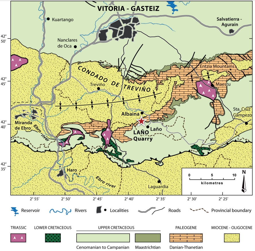
| Geological Setting | Basque-Cantabrian Basin, Navarra-Álava trough |
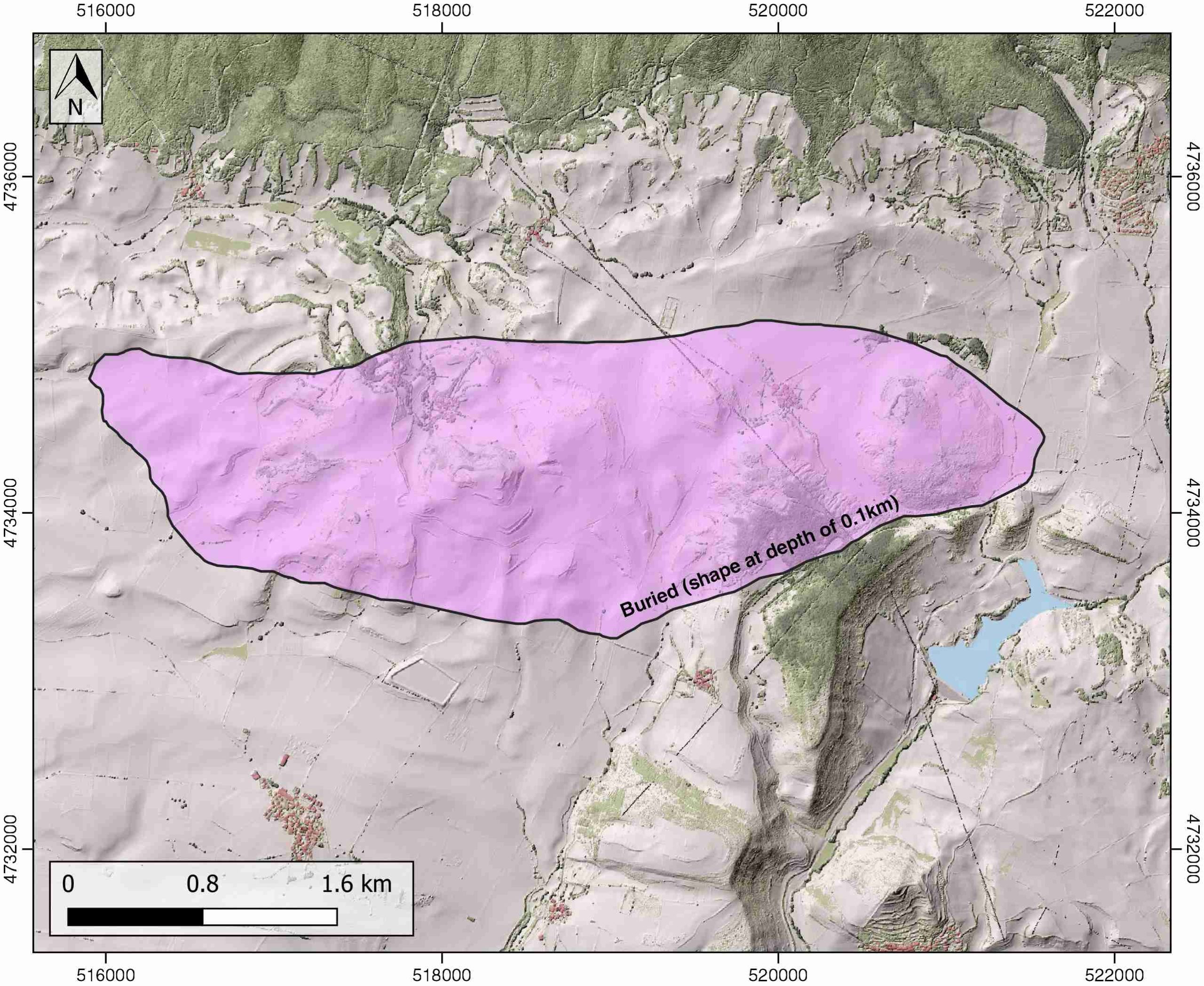
| Outcropping/buried | Buried |
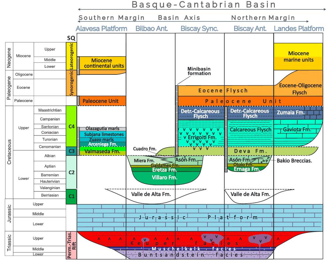
| Evaporite unit/s name | Keuper facies |
| Evaporite unit/s age | Carnian-Rhaetian (Upper Triassic) |
| Evaporite unit/s origin | Marine |
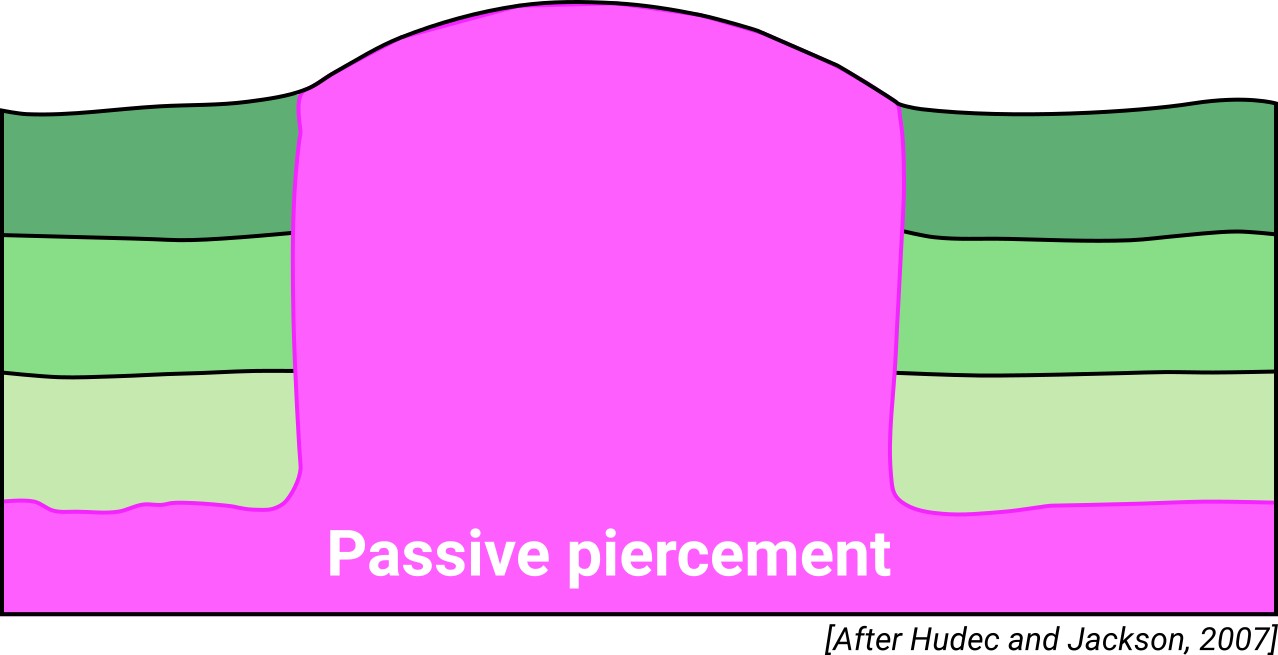
| Classif. (Hudec and Jackson, 2009) | Passive piercement |
| Classif. (Jackson and Talbot, 1986) | Salt pillow |
| Age of evaporite flow or deformation (when deformed) | Middle Cretaceous |
| Other comments | Some of the associated listric faults formed the largest depocenters of the BCB, which were subsequently accentuated during the Alpine compression, such as the Polientes-Sedano, Villarcayo-Treviño and the Biscay synclines. |
Generic Data
| Unique ID | 55 |
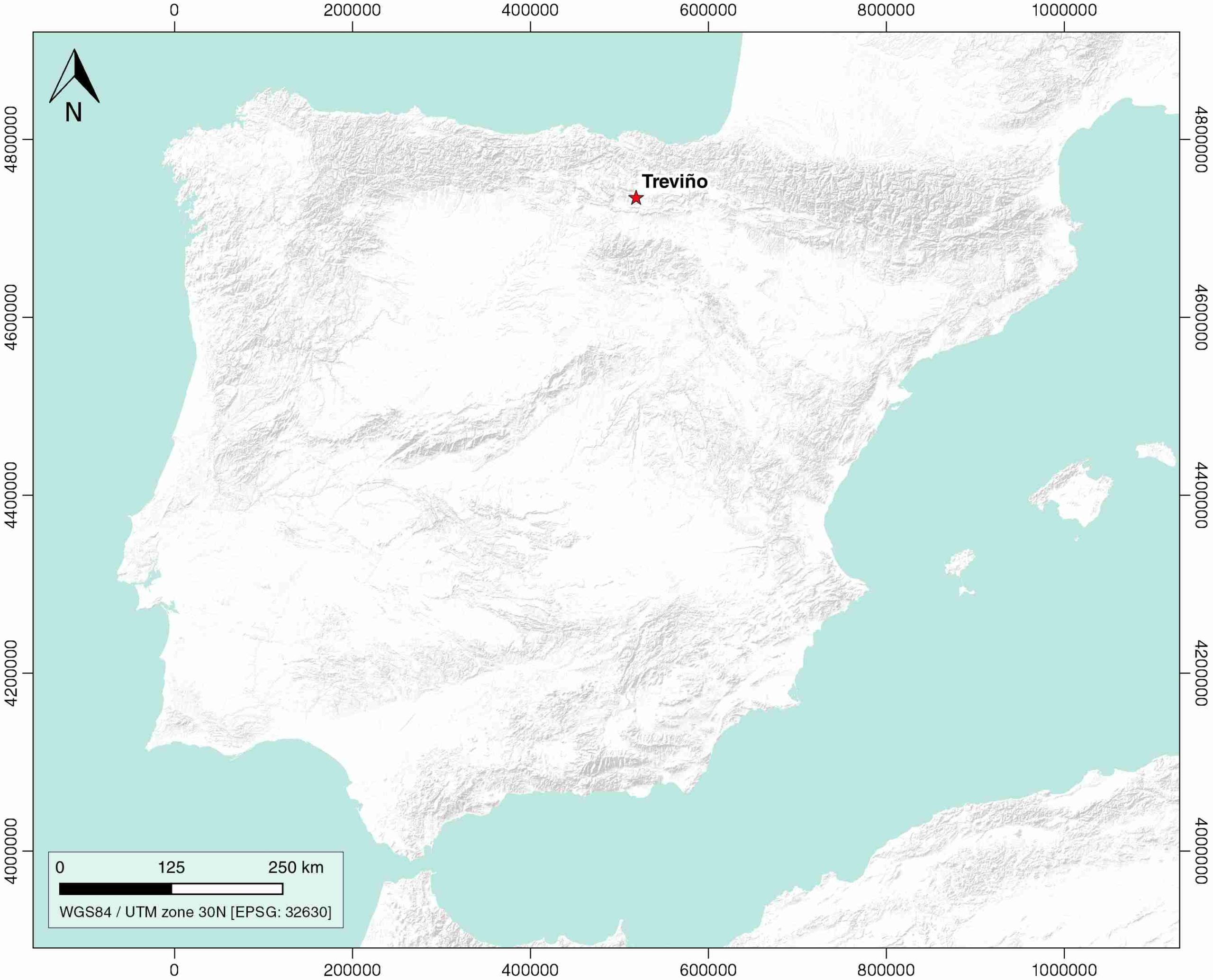
| Name | Treviño |
| Structure type | Evaporite diapir |
| Deformed/Undeformed | Deformed |
| Buried/Outcropping | Buried |
| Geological setting | Basque-Cantabrian Basin |
| Geological Regional Setting | Navarra-Álava trough |
| Evaporite unit/s name | Keuper facies |
| Evaporite unit/s age | Carnian-Rhaetian (Upper Triassic) |
| Evaporite unit/s era | Mesozoic |
| Evaporite unit/s origin | Marine |
| Evaporite unit/s composition | Gypsum-Marlstones-Claystone-Shale |
| Post-kinematic unit/s (or post-evaporite units when evaporites are undeformed) | Upper Cretaceous (Páramos Fm., limestones), Palaeocene (limestones and marly limestones), Quaternary |
| Post-kinematic unit/s age (or post-evaporite units when evaporites are undeformed) | Upper Cretaceous-Holocene |
| Classification (Hudec and Jackson, 2009) | Passive piercement |
| Classification (Jackson and Talbot, 1986) | Salt pillow |
| Mining activity? | N |
| Mining activity start | |
| Mining activity end | |
| Mining galleries? | |
| Mining products | |
| Mining sub-products | |
| Evaporite flow? | Y |
| Age of evaporite flow | Upper Albian – Cenomanian |
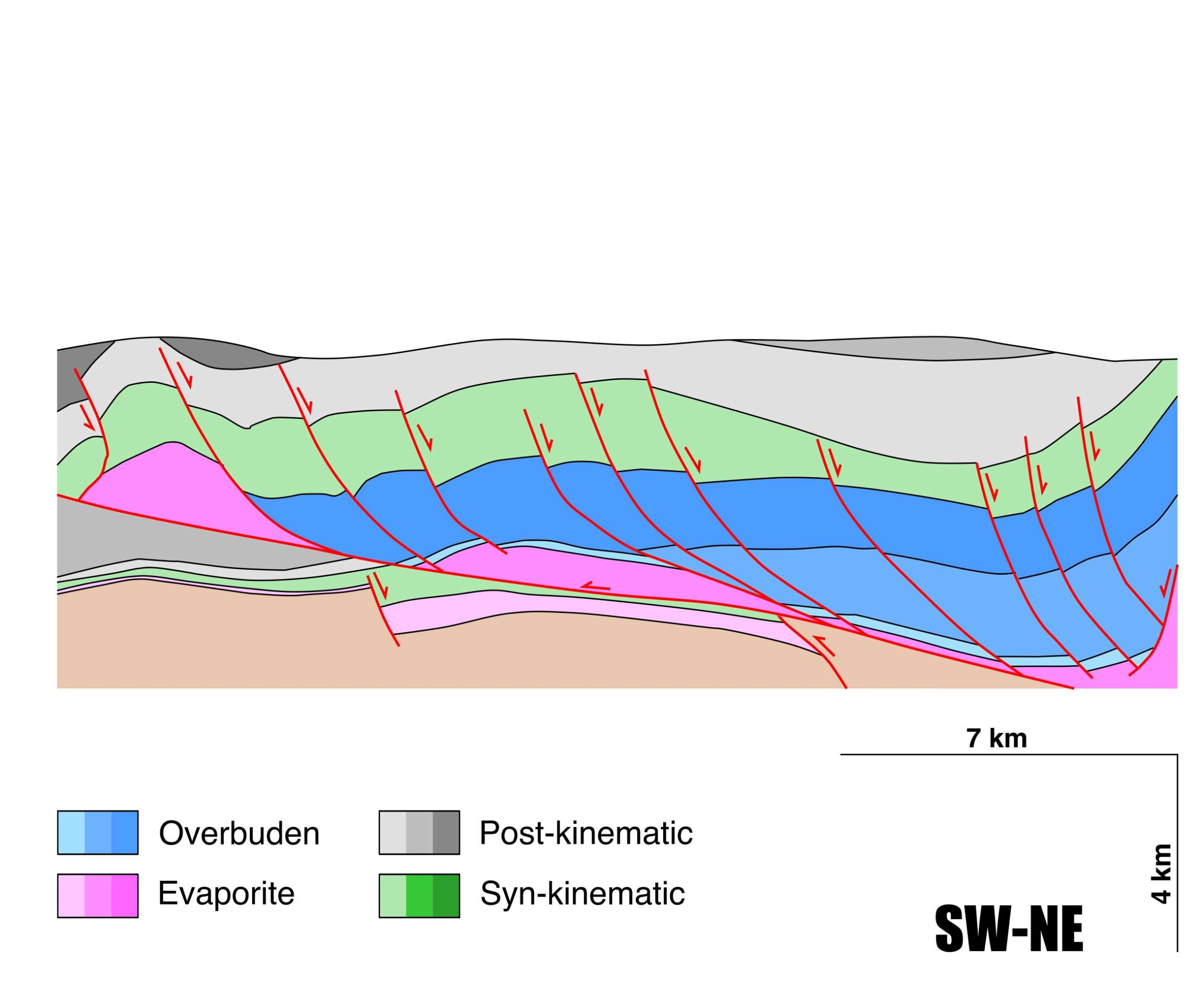
| Flow or deformation triggering mechanisms | North dipping listric faults |
| Flow-linked structures? | Y |
| Halokinetic structures | Normal high-angle faults / thrust faults / thickness variations |
| Post-evaporite and pre-kinematic unit/s (overbuden) | Clays, limestones and sandstones (Purbeck facies, Late Jurassic – Early Cretaceous) ; limestones and sandstones (Weald, mid-Lower Cretaceous) ; limestones and sandstones (Urgonian, Aptian – Albian) |
| Syn-kinematic unit/s | Upper Albian – Cenomanian (Supraurgonian, Valmaseda Fm., shales and sandstones) |
| Available seismic profiles | MARCONI WA / GA-2 / GA-3 / CA-30 / R-42 / R-46 / CB-4 / CA-30 / AN-02 / GA-3 / GA-2 / P-2-BIS / R-46-1 / R-46-2 / R-46 / R-42 / 13-D |
| Available boreholes | CASTILLO-5 / TREVIÑO-0003 / TREVIÑO-0004 / AÑASTRO-1 / TREVIÑO-1006 / TREVIÑO-0001 / TREVIÑO-1004 / TREVIÑO-1005 |
| Additional comments | Some of the listric faults formed the largest depocenters of the BCB, which were subsequently accentuated during the Alpine compression, such as the Polientes-Sedano, Villarcayo-Treviño and the Biscay synclines. |
Mining Data
| UNIQUE_ID | 55 |
| Minning exploitations within <2km? | N |
| Historical/Active | |
| Exploitation name #1 | |
| Exploitation ID (Spanish National Mining Cadastre) #1 | |
| Municipality #1 | |
| Province #1 | |
| Company #1 | |
| Main minning Products #1 | |
| Exploitation name #2 | |
| Exploitation ID (Spanish National Mining Cadastre) #2 | |
| Municipality #2 | |
| Province #2 | |
| Company #2 | |
| Main minning Products #2 | |
| Exploitation name #3 | |
| Exploitation ID (Spanish National Mining Cadastre) #3 | |
| Municipality #3 | |
| Province #3 | |
| Company #3 | |
| Main minning Products #3 |
Quantitative Data
| UNIQUE_ID | 55 |
| Outcropping area (km2) | Buried |
| Horizontal intersection area (km2) (when buried) | 7.22557 |
| Depth of intersection area (km2) (when buried) | 0.1 |
| Max. Width (Km) | 1.89784207 |
| Max. Length (Km) | 5.68376097 |
| Max. Evaporites thickness (km) | 1 |
| Max. Deformation age (Ma) | 105 |
| Min. Deformation age (Ma) | 94 |
| Deformation stages | 1 |
Reference Data
| UNIQUE_ID | 55 |
| Section source | Cámara, P., 2017. Salt and Strike-Slip Tectonics as Main Drivers in the Structural Evolution of the Basque-Cantabrian Basin, Spain. In Permo-Triassic Salt Provinces of Europe, North Africa and the Atlantic Margins (pp. 371-393). Elsevier. [link] |
| Well / Borehole availability #1 | Cámara, P., 2020. Inverted turtle salt anticlines in the eastern basque-cantabrian basin, Spain. Marine and Petroleum Geology, 104358. [link] |
| Well / Borehole availability #2 | n.a. |
| Available data (Stratigraphy) #1 | Cámara, P., 2017. Salt and Strike-Slip Tectonics as Main Drivers in the Structural Evolution of the Basque-Cantabrian Basin, Spain. In Permo-Triassic Salt Provinces of Europe, North Africa and the Atlantic Margins (pp. 371-393). Elsevier. [link] |
| Available data (Stratigraphy) #2 | Cámara, P., 2020. Inverted turtle salt anticlines in the eastern basque-cantabrian basin, Spain. Marine and Petroleum Geology, 104358. [link] |
| Available data (Stratigraphy) #3 | García-Mondéjar, J., Pujalte, V., Robles, S., 1986. Características sedimentológicas secuenciales y tectoestratigráficas del Triásico de Cantabria y norte de Palencia. Cuadernos de Geología Ibérica, 10, 151-172. [link] |
| Available data (Stratigraphy) #4 | Pujalte, V., Robles, S., Orue-Etxebarria, X., Baceta, J. I., Payros, A., Larruzea, I. F., 2000. Uppermost Cretaceous-Middle Eocene strata of the Basque-Cantabrian Region and western Pyrenees: a sequence stratigraphic perspective. Revista de la Sociedad Geológica de España, 13(2), 191-211. [link] |
| Available data (Stratigraphy) #5 | n.a. |
| Available data (Stratigraphy) #6 | n.a. |
| Regional Stratigraphy | Pedrera, A., García‐Senz, J., Ayala, C., Ruiz‐Constán, A., Rodríguez‐Fernández, L. R., Robador, A., González Menéndez, L., 2017. Reconstruction of the exhumed mantle across the North Iberian Margin by crustal‐scale 3‐D gravity inversion and geological cross section. Tectonics, 36, 3155-3177. [link] |
| Seismic data availability #1 | Cámara, P., 2017. Salt and Strike-Slip Tectonics as Main Drivers in the Structural Evolution of the Basque-Cantabrian Basin, Spain. In Permo-Triassic Salt Provinces of Europe, North Africa and the Atlantic Margins (pp. 371-393). Elsevier. [link] |
| Seismic data availability #2 | Cámara, P., 2020. Inverted turtle salt anticlines in the eastern basque-cantabrian basin, Spain. Marine and Petroleum Geology, 104358. [link] |
| Seismic data availability #3 | Gallart Muset, J., Pulgar, J. A., Muñoz, J. A., Diaz, J., Ruiz Fernández, M., 2020. Litospheric Structure of the North Iberian Margin: MARCONI-WA reflection profiles. DigitalCSIC – SEISDARE data repository. [link] |
| Available data (Structure) #1 | Cámara, P., 2020. Inverted turtle salt anticlines in the eastern basque-cantabrian basin, Spain. Marine and Petroleum Geology, 104358. [link] |
| Available data (Structure) #2 | Pedrera, A., García‐Senz, J., Ayala, C., Ruiz‐Constán, A., Rodríguez‐Fernández, L. R., Robador, A., González Menéndez, L., 2017. Reconstruction of the exhumed mantle across the North Iberian Margin by crustal‐scale 3‐D gravity inversion and geological cross section. Tectonics, 36, 3155-3177. [link] |
| Available data (Structure) #3 | Junguitu, J., Eguíluz, L., Sarrionandia, F., 2018. Geomorphology of the Valdegovía valley (Basque-Cantabrian Basin, Northern Spain): an example of a sub-Mediterranean, low-mid mountainous, structurally controlled area. Journal of Maps, 14(2), 552-560. [link] |
| Available data (Structure) #4 | Cámara, P., 2017. Salt and Strike-Slip Tectonics as Main Drivers in the Structural Evolution of the Basque-Cantabrian Basin, Spain. In Permo-Triassic Salt Provinces of Europe, North Africa and the Atlantic Margins (pp. 371-393). Elsevier. [link] |
| Available data (Structure) #5 | n.a. |
| Available data (Structure) #6 | n.a. |
| Available data (Analogue modelling) #1 | n.a. |
| Available data (Analogue modelling) #2 | n.a. |
| Available data (Analogue modelling) #3 | n.a. |
| Available data (Gravimetry – Tomography) #1 | Pedrera, A., García‐Senz, J., Ayala, C., Ruiz‐Constán, A., Rodríguez‐Fernández, L. R., Robador, A., González Menéndez, L., 2017. Reconstruction of the exhumed mantle across the North Iberian Margin by crustal‐scale 3‐D gravity inversion and geological cross section. Tectonics, 36, 3155-3177. [link] |
| Available data (Gravimetry – Tomography) #2 | Pinto, V., Casas, A., Rivero, L., Torne, M., 2005. 3D gravity modeling of the Triassic salt diapirs of the Cubeta Alavesa (northern Spain). Tectonophysics, 405, 65-75. [link] |
| Available data (Gravimetry – Tomography) #3 | Ayala, C., Bohoyo, F., Maestro, A., Reguera, M. I., Torne, M., Rubio, F., Fernández, M., García-Lobón, J. L., 2016. Updated Bouguer anomalies of the Iberian Peninsula: a new perspective to interpret the regional geology. Journal of Maps, 12(5), 1089-1092. [link] |
| Available data (Geochemistry) #1 | Marín, P., Márquez, G., Gallego, J. R., Permanyer, A., 2014. Characterization of asphaltic oil occurrences from the southeastern margin of the Basque-Cantabrian Basin, Spain. Geologica Acta, 12(4), 327-342. [link] |
| Available data (Geochemistry) #2 | Permanyer, A., Martín-Martín, J. D., Kihle, J., Márquez, G., Marfil, R., 2018. Oil shows geochemistry and fluid inclusion thermometry of Mid Cretaceous carbonates from the eastern Basque Cantabrian Basin (N Spain). Marine and Petroleum Geology, 92, 255-269. [link] |
| Available data (Geochemistry) #3 | Ortí, F., García-Veigas, J., Rossell, L., Jurado, M. J., Utrilla, R., 1996. Formaciones salinas de las cuencas triásicas en la Península Ibérica: Caracterización Petrológica y Geoquímica. Cuadernos de Geología Ibérica, 20, 13-35. [link] |
| Available data (Geochemistry) #4 | n.a. |
| Available data (Petrophysics) #1 | Llamas, B., Castañeda, M. C., Laín, C., Pous, J., 2017. Study of the Basque–Cantabrian basin as a suitable region for the implementation of an energy storage system based on compressed air energy storage (CAES). Environmental Earth Sciences, 76(5), 204. [link] |
| Available data (Petrophysics) #2 | Soto, R., Beamud, E., Roca, E., Carola, E., Almar, Y., 2017. Distinguishing the effect of diapir growth on magnetic fabrics of syn-diapiric overburden rocks: Basque-Cantabrian basin, Northern Spain. Terra Nova 29, 191-201. [link] |
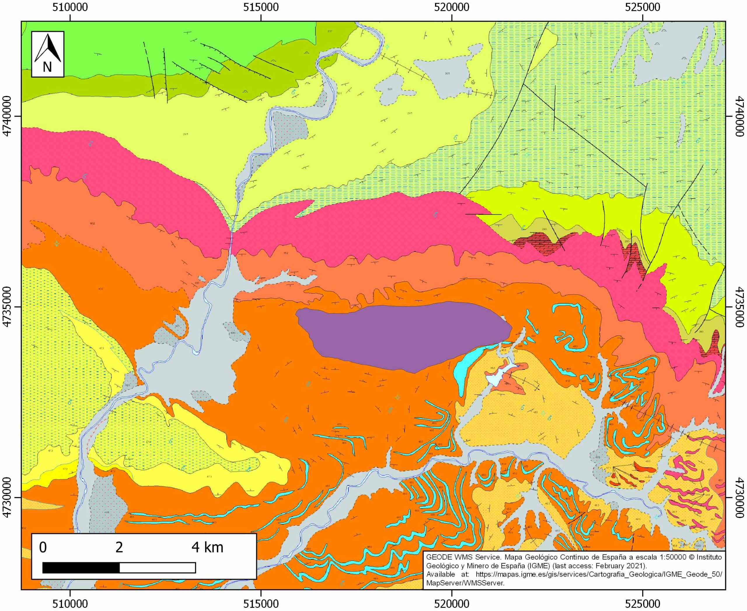
| IGME Geological Map (MAGNA50) Sheet number | 138-La Puebla de Arganzón. [link] |
| Other Maps #1 (source) | Perona, J., 2016. Mineralizaciones de Pb-Zn asociadas a los diapiros de Murguía y Orduña (Cuenca Vasco-Cantábrica) [PhD thesis]: Barcelona, Universitat de Barcelona, 281 pp. [link] |
| Other Maps #2 (source) | Pereda-Suberbiola, X., Corral, J. C., Astibia, H., Badiola, A., Bardet, N., Berreteaga, A., …, Torices, A., 2015. Late Cretaceous continental and marine vertebrate assemblages of the Laño Quarry (Basque-Cantabrian Region, Iberian Peninsula): an update. Journal of Iberian Geology, 41(1), 101-124. [link] |
| Other related references #1 | Olivar Castaño, A., Pedreira Rodríguez, D., Álvarez Pulgar, F. J., González Cortina, J. M., Díaz González, A., Pie Perales, L., …, Ruiz, M., 2018. Seismic tomography in the Basque-Cantabrian basin: Rayleigh wave phase velocities, Vp, Vs and Vp/Vs determined from ambient noise and local events across the SISCAN seismic network. EGUGA, 8775. [link] |
| Other related references #2 | Tugend, J., Manatschal, G., Kusznir, N. J., Masini, E., Mohn, G., Thinon, I., 2014. Formation and deformation of hyperextended rift systems: Insights from rift domain mapping in the Bay of Biscay‐Pyrenees. Tectonics, 33(7), 1239-1276. [link] |
| Other related references #3 | n.a. |
| Other related references #4 | n.a. |
Well and Seismic Data
| UNIQUE_ID | 55 |
| Seismic survey name #1 | MARCONI WA |
| Across structure? #1 | Y |
| Seismic profile ID (IGME) #1 | n.a. |
| Seismic profile code #1 | n.a. |
| Seismic profile name #1 | n.a. |
| Seismic survey year #1 | n.a. |
| Data repository #1 | SeisDARE Database: https://digital.csic.es/handle/10261/101879 |
| Length (km) #1 | 74.34 |
| Seismic survey name #2 | 8C-ST-181 |
| Across structure? #2 | Y |
| Seismic profile ID (IGME) #2 | 13256 |
| Seismic profile code #2 | 17974 |
| Seismic profile name #2 | GA-2 |
| Seismic survey year #2 | 1966 |
| Data repository #2 | SIGEOF Data Catalogue (Private access section). ©Instituto Geológico y Minero de España (IGME). https://info.igme.es/SIGEOF/ |
| Length (km) #2 | 7.85 |
| Seismic survey name #3 | 8C-ST-181 |
| Across structure? #3 | Y |
| Seismic profile ID (IGME) #3 | 13255 |
| Seismic profile code #3 | 17973 |
| Seismic profile name #3 | GA-3 |
| Seismic survey year #3 | 1966 |
| Data repository #3 | SIGEOF Data Catalogue (Private access section). ©Instituto Geológico y Minero de España (IGME). https://info.igme.es/SIGEOF/ |
| Length (km) #3 | 8.24 |
| Seismic survey name #4 | 8C-ST-95 |
| Across structure? #4 | Y |
| Seismic profile ID (IGME) #4 | 13339 |
| Seismic profile code #4 | 18057 |
| Seismic profile name #4 | CA-30 |
| Seismic survey year #4 | 1967 |
| Data repository #4 | SIGEOF Data Catalogue (Private access section). ©Instituto Geológico y Minero de España (IGME). https://info.igme.es/SIGEOF/ |
| Length (km) #4 | 7.39 |
| Seismic survey name #5 | 8C-ST-180 |
| Across structure? #5 | Y |
| Seismic profile ID (IGME) #5 | 13246 |
| Seismic profile code #5 | 17964 |
| Seismic profile name #5 | R-42 |
| Seismic survey year #5 | 1960 |
| Data repository #5 | SIGEOF Data Catalogue (Private access section). ©Instituto Geológico y Minero de España (IGME). https://info.igme.es/SIGEOF/ |
| Length (km) #5 | 9.62 |
| Seismic survey name #6 | 8C-ST-180 |
| Across structure? #6 | Y |
| Seismic profile ID (IGME) #6 | 13244 |
| Seismic profile code #6 | 17962 |
| Seismic profile name #6 | R-46 |
| Seismic survey year #6 | 1967 |
| Data repository #6 | SIGEOF Data Catalogue (Private access section). ©Instituto Geológico y Minero de España (IGME). https://info.igme.es/SIGEOF/ |
| Length (km) #6 | 3.07 |
| Seismic survey name #7 | 8C-ST-108 |
| Across structure? #7 | N (within 3km) |
| Seismic profile ID (IGME) #7 | 13176 |
| Seismic profile code #7 | 17894 |
| Seismic profile name #7 | CB-4 |
| Seismic survey year #7 | 1968 |
| Data repository #7 | SIGEOF Data Catalogue (Section available under request). ©Instituto Geológico y Minero de España (IGME). https://info.igme.es/SIGEOF/ |
| Length (km) #7 | 18.20 |
| Seismic survey name #8 | 8C-ST-95 |
| Across structure? #8 | N (within 3km) |
| Seismic profile ID (IGME) #8 | 13339 |
| Seismic profile code #8 | 18057 |
| Seismic profile name #8 | CA-30 |
| Seismic survey year #8 | 1967 |
| Data repository #8 | SIGEOF Data Catalogue (Private access section). ©Instituto Geológico y Minero de España (IGME). https://info.igme.es/SIGEOF/ |
| Length (km) #8 | 7.39 |
| Seismic survey name #9 | 0001A80G |
| Across structure? #9 | N (within 3km) |
| Seismic profile ID (IGME) #9 | 5487 |
| Seismic profile code #9 | 7912 |
| Seismic profile name #9 | AN-02 |
| Seismic survey year #9 | 1980 |
| Data repository #9 | SIGEOF Data Catalogue (Private access section). ©Instituto Geológico y Minero de España (IGME). https://info.igme.es/SIGEOF/ |
| Length (km) #9 | 10.25 |
| Seismic survey name #10 | 8C-ST-181 |
| Across structure? #10 | N (within 3km) |
| Seismic profile ID (IGME) #10 | 13255 |
| Seismic profile code #10 | 17973 |
| Seismic profile name #10 | GA-3 |
| Seismic survey year #10 | 1966 |
| Data repository #10 | SIGEOF Data Catalogue (Private access section). ©Instituto Geológico y Minero de España (IGME). https://info.igme.es/SIGEOF/ |
| Length (km) #10 | 8.24 |
| Seismic survey name #11 | 8C-ST-181 |
| Across structure? #11 | N (within 3km) |
| Seismic profile ID (IGME) #11 | 13256 |
| Seismic profile code #11 | 17974 |
| Seismic profile name #11 | GA-2 |
| Seismic survey year #11 | 1966 |
| Data repository #11 | SIGEOF Data Catalogue (Private access section). ©Instituto Geológico y Minero de España (IGME). https://info.igme.es/SIGEOF/ |
| Length (km) #11 | 7.85 |
| Seismic survey name #12 | 8C-ST-182 |
| Across structure? #12 | N (within 3km) |
| Seismic profile ID (IGME) #12 | 13268 |
| Seismic profile code #12 | 17986 |
| Seismic profile name #12 | P-2-BIS |
| Seismic survey year #12 | 1958 |
| Data repository #12 | SIGEOF Data Catalogue (Private access section). ©Instituto Geológico y Minero de España (IGME). https://info.igme.es/SIGEOF/ |
| Length (km) #12 | 10.99 |
| Seismic survey name #13 | 8C-ST-180 |
| Across structure? #13 | N (within 3km) |
| Seismic profile ID (IGME) #13 | 13243 |
| Seismic profile code #13 | 17961 |
| Seismic profile name #13 | R-46-1 |
| Seismic survey year #13 | 1967 |
| Data repository #13 | SIGEOF Data Catalogue (Private access section). ©Instituto Geológico y Minero de España (IGME). https://info.igme.es/SIGEOF/ |
| Length (km) #13 | 2.16 |
| Seismic survey name #14 | 8C-ST-180 |
| Across structure? #14 | N (within 3km) |
| Seismic profile ID (IGME) #14 | 13242 |
| Seismic profile code #14 | 17960 |
| Seismic profile name #14 | R-46-2 |
| Seismic survey year #14 | 1967 |
| Data repository #14 | SIGEOF Data Catalogue (Private access section). ©Instituto Geológico y Minero de España (IGME). https://info.igme.es/SIGEOF/ |
| Length (km) #14 | 1.89 |
| Seismic survey name #15 | 8C-ST-180 |
| Across structure? #15 | N (within 3km) |
| Seismic profile ID (IGME) #15 | 13244 |
| Seismic profile code #15 | 17962 |
| Seismic profile name #15 | R-46 |
| Seismic survey year #15 | 1967 |
| Data repository #15 | SIGEOF Data Catalogue (Private access section). ©Instituto Geológico y Minero de España (IGME). https://info.igme.es/SIGEOF/ |
| Length (km) #15 | 3.07 |
| Seismic survey name #16 | 8C-ST-180 |
| Across structure? #16 | N (within 3km) |
| Seismic profile ID (IGME) #16 | 13246 |
| Seismic profile code #16 | 17964 |
| Seismic profile name #16 | R-42 |
| Seismic survey year #16 | 1960 |
| Data repository #16 | SIGEOF Data Catalogue (Private access section). ©Instituto Geológico y Minero de España (IGME). https://info.igme.es/SIGEOF/ |
| Length (km) #16 | 9.62 |
| Seismic survey name #17 | 8C-ST-111 |
| Across structure? #17 | N (within 3km) |
| Seismic profile ID (IGME) #17 | 13211 |
| Seismic profile code #17 | 17929 |
| Seismic profile name #17 | 13-D |
| Seismic survey year #17 | 1959 |
| Data repository #17 | SIGEOF Data Catalogue (Private access section). ©Instituto Geológico y Minero de España (IGME). https://info.igme.es/SIGEOF/ |
| Length (km) #17 | 1.11 |
| Seismic survey name #18 | |
| Across structure? #18 | |
| Seismic profile ID (IGME) #18 | |
| Seismic profile code #18 | |
| Seismic profile name #18 | |
| Seismic survey year #18 | |
| Data repository #18 | |
| Length (km) #18 | |
| Seismic survey name #19 | |
| Across structure? #19 | |
| Seismic profile ID (IGME) #19 | |
| Seismic profile code #19 | |
| Seismic profile name #19 | |
| Seismic survey year #19 | |
| Data repository #19 | |
| Length (km) #19 | |
| Seismic survey name #20 | |
| Across structure? #20 | |
| Seismic profile ID (IGME) #20 | |
| Seismic profile code #20 | |
| Seismic profile name #20 | |
| Seismic survey year #20 | |
| Data repository #20 | |
| Length (km) #20 | |
| Seismic survey name #21 | |
| Across structure? #21 | |
| Seismic profile ID (IGME) #21 | |
| Seismic profile code #21 | |
| Seismic profile name #21 | |
| Seismic survey year #21 | |
| Data repository #21 | |
| Length (km) #21 | |
| Borehole name #1 | CASTILLO-5 |
| Company #1 | SHELL/CEPSA |
| Traget #1 | HYDROCARBONS |
| Across structure? #1 | N (within 5 km) |
| Borehole name #2 | TREVIÑO-0003 |
| Company #2 | SHELL/CEPSA/FINA |
| Traget #2 | HYDROCARBONS |
| Across structure? #2 | N (within 5 km) |
| Borehole name #3 | TREVIÑO-0004 |
| Company #3 | SHELL/CEPSA |
| Traget #3 | HYDROCARBONS |
| Across structure? #3 | N (within 5 km) |
| Borehole name #4 | AÑASTRO-1 |
| Company #4 | SHELL/CEPSA |
| Traget #4 | HYDROCARBONS |
| Across structure? #4 | N (within 5 km) |
| Borehole name #5 | TREVIÑO-1006 |
| Company #5 | CEPSA |
| Traget #5 | HYDROCARBONS |
| Across structure? #5 | N (within 5 km) |
| Borehole name #6 | TREVIÑO-0001 |
| Company #6 | CEPSA |
| Traget #6 | HYDROCARBONS |
| Across structure? #6 | N (within 5 km) |
| Borehole name #7 | TREVIÑO-1004 |
| Company #7 | CEPSA |
| Traget #7 | HYDROCARBONS |
| Across structure? #7 | N (within 5 km) |
| Borehole name #8 | TREVIÑO-1005 |
| Company #8 | CEPSA |
| Traget #8 | HYDROCARBONS |
| Across structure? #8 | N (within 5 km) |
| Borehole name #9 | |
| Company #9 | |
| Traget #9 | |
| Across structure? #9 | |
| Borehole name #10 | |
| Company #10 | |
| Traget #10 | |
| Across structure? #10 | |
| Borehole name #11 | |
| Company #11 | |
| Traget #11 | |
| Across structure? #11 | |
| Borehole name #12 | |
| Company #12 | |
| Traget #12 | |
| Across structure? #12 | |
| Borehole name #13 | |
| Company #13 | |
| Traget #13 | |
| Across structure? #13 | |
| Borehole name #14 | |
| Company #14 | |
| Traget #14 | |
| Across structure? #14 | |
| Borehole name #15 | |
| Company #15 | |
| Traget #15 | |
| Across structure? #15 |
Geographical Data (EPSG:4326 - WGS 84)
| UNIQUE_ID | 55 |
| X Centroid (Structure shape) | -2.770966 |
| Y Centroid (Structure shape) | -2.770966 |
| Xmin (Structure shape) | -2.805640 |
| Xmax (Structure shape) | -2.736218 |
| Ymin (Structure shape) | 42.751568 |
| Ymax (Structure shape) | 42.768566 |
| Xmin seismic line #1 | -2.765400 |
| Xmax seismic line #1 | -2.744300 |
| Ymin seismic line #1 | 42.720000 |
| Ymax seismic line #1 | 43.389000 |
| Xmin seismic line #2 | -2.822930 |
| Xmax seismic line #2 | -2.748412 |
| Ymin seismic line #2 | 42.735930 |
| Ymax seismic line #2 | 42.780295 |
| Xmin seismic line #3 | -2.794064 |
| Xmax seismic line #3 | -2.747585 |
| Ymin seismic line #3 | 42.713440 |
| Ymax seismic line #3 | 42.779186 |
| Xmin seismic line #4 | -2.863004 |
| Xmax seismic line #4 | -2.785380 |
| Ymin seismic line #4 | 42.739903 |
| Ymax seismic line #4 | 42.773743 |
| Xmin seismic line #5 | -2.827608 |
| Xmax seismic line #5 | -2.736758 |
| Ymin seismic line #5 | 42.727472 |
| Ymax seismic line #5 | 42.781125 |
| Xmin seismic line #6 | -2.811391 |
| Xmax seismic line #6 | -2.795338 |
| Ymin seismic line #6 | 42.758101 |
| Ymax seismic line #6 | 42.782226 |
| Xmin seismic line #7 | -2.817452 |
| Xmax seismic line #7 | -2.628574 |
| Ymin seismic line #7 | 42.708833 |
| Ymax seismic line #7 | 42.791521 |
| Xmin seismic line #8 | -2.863004 |
| Xmax seismic line #8 | -2.785380 |
| Ymin seismic line #8 | 42.739903 |
| Ymax seismic line #8 | 42.773743 |
| Xmin seismic line #9 | -2.778297 |
| Xmax seismic line #9 | -2.660710 |
| Ymin seismic line #9 | 42.722756 |
| Ymax seismic line #9 | 42.753896 |
| Xmin seismic line #10 | -2.794064 |
| Xmax seismic line #10 | -2.747585 |
| Ymin seismic line #10 | 42.713440 |
| Ymax seismic line #10 | 42.779186 |
| Xmin seismic line #11 | -2.822930 |
| Xmax seismic line #11 | -2.748412 |
| Ymin seismic line #11 | 42.735930 |
| Ymax seismic line #11 | 42.780295 |
| Xmin seismic line #12 | -2.885514 |
| Xmax seismic line #12 | -2.776720 |
| Ymin seismic line #12 | 42.671269 |
| Ymax seismic line #12 | 42.727780 |
| Xmin seismic line #13 | -2.820259 |
| Xmax seismic line #13 | -2.812055 |
| Ymin seismic line #13 | 42.738493 |
| Ymax seismic line #13 | 42.756878 |
| Xmin seismic line #14 | -2.827437 |
| Xmax seismic line #14 | -2.819245 |
| Ymin seismic line #14 | 42.731768 |
| Ymax seismic line #14 | 42.746956 |
| Xmin seismic line #15 | -2.811391 |
| Xmax seismic line #15 | -2.795338 |
| Ymin seismic line #15 | 42.758101 |
| Ymax seismic line #15 | 42.782226 |
| Xmin seismic line #16 | -2.827608 |
| Xmax seismic line #16 | -2.736758 |
| Ymin seismic line #16 | 42.727472 |
| Ymax seismic line #16 | 42.781125 |
| Xmin seismic line #17 | -2.805267 |
| Xmax seismic line #17 | -2.794522 |
| Ymin seismic line #17 | 42.731363 |
| Ymax seismic line #17 | 42.737486 |
| Xmin seismic line #18 | |
| Xmax seismic line #18 | |
| Ymin seismic line #18 | |
| Ymax seismic line #18 | |
| Xmin seismic line #19 | |
| Xmax seismic line #19 | |
| Ymin seismic line #19 | |
| Ymax seismic line #19 | |
| Xmin seismic line #20 | |
| Xmax seismic line #20 | |
| Ymin seismic line #20 | |
| Ymax seismic line #20 | |
| Xmin seismic line #21 | |
| Xmax seismic line #21 | |
| Ymin seismic line #21 | |
| Ymax seismic line #21 | |
| X borehole #1 | -2.729264 |
| Y borehole #1 | 42.804736 |
| X borehole #2 | -2.700373 |
| Y borehole #2 | 42.724372 |
| X borehole #3 | -2.724267 |
| Y borehole #3 | 42.743064 |
| X borehole #4 | -2.770353 |
| Y borehole #4 | 42.746120 |
| X borehole #5 | -2.750378 |
| Y borehole #5 | 42.742512 |
| X borehole #6 | -2.730658 |
| Y borehole #6 | 42.731426 |
| X borehole #7 | -2.722873 |
| Y borehole #7 | 42.732236 |
| X borehole #8 | -2.739546 |
| Y borehole #8 | 42.753069 |
| X borehole #9 | |
| Y borehole #9 | |
| X borehole #10 | |
| Y borehole #10 | |
| X borehole #11 | |
| Y borehole #11 | |
| X borehole #12 | |
| Y borehole #12 | |
| X borehole #13 | |
| Y borehole #13 | |
| X borehole #14 | |
| Y borehole #14 | |
| X borehole #15 | |
| Y borehole #15 |

