Villasana de Mena
ID #014
General Information
| Structure type | Evaporite Diapir |
| Deformed/Undeformed | Deformed |
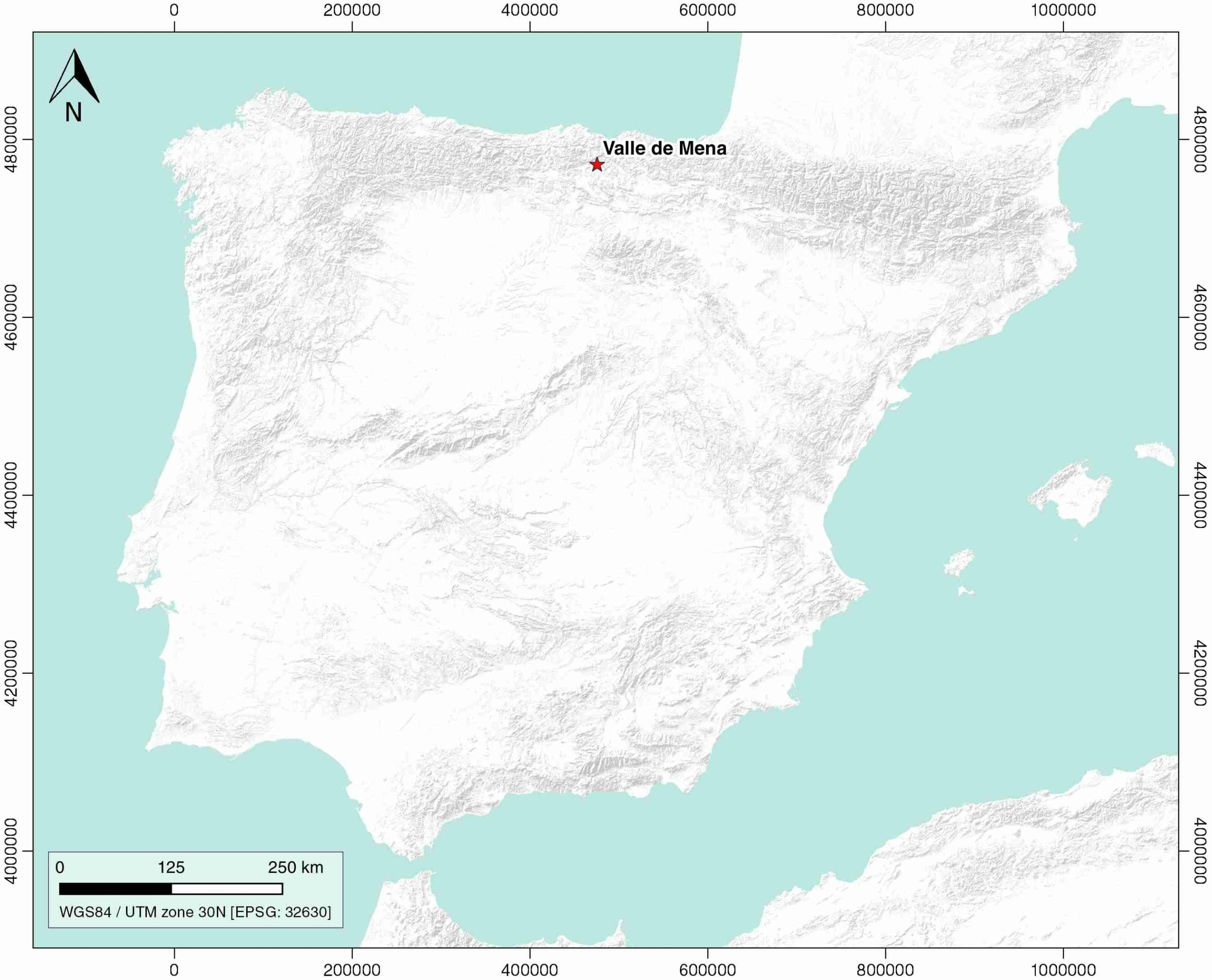
| Geological Setting | Basque-Cantabrian Basin, Navarra-Álava trough |
| Outcropping/buried | Outcropping |
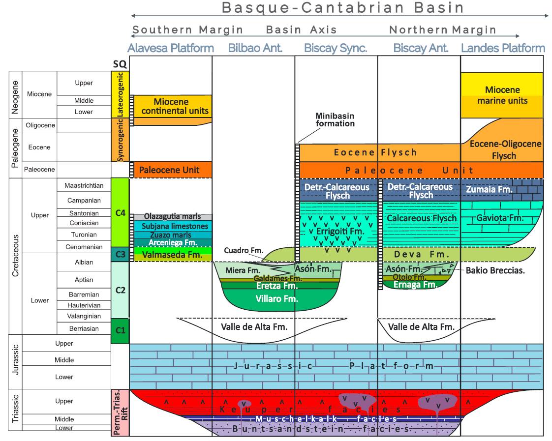
| Evaporite unit/s name | Keuper facies |
| Evaporite unit/s age | Carnian-Rhaetian (Upper Triassic) |
| Evaporite unit/s origin | Marine |
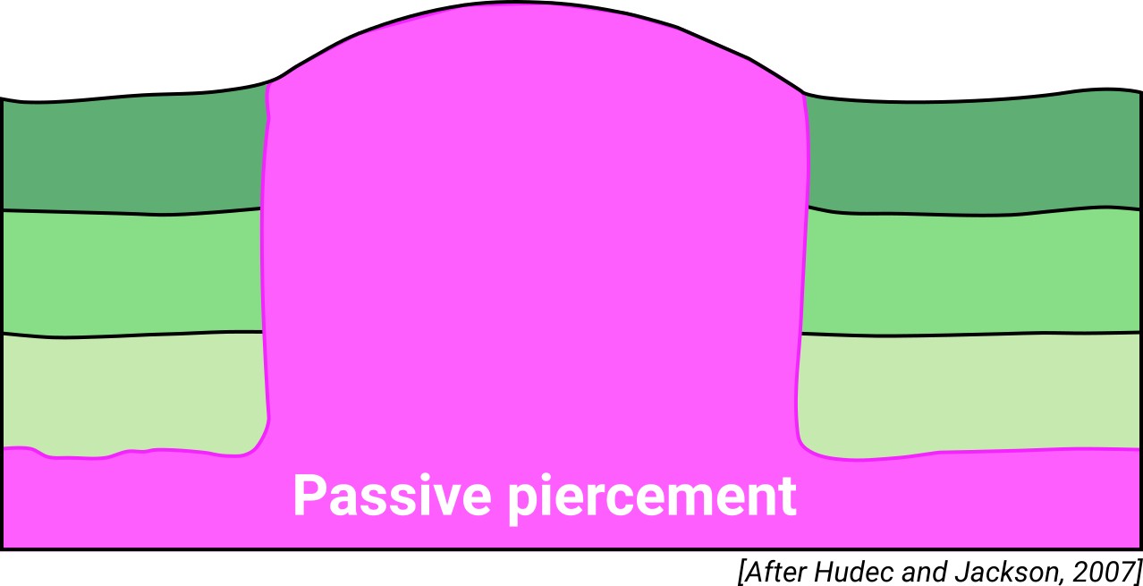
| Classif. (Hudec and Jackson, 2009) | Passive piercement |
| Classif. (Jackson and Talbot, 1986) | Salt stock |
| Age of evaporite flow or deformation (when deformed) | Eocene, Middle Cretaceous |
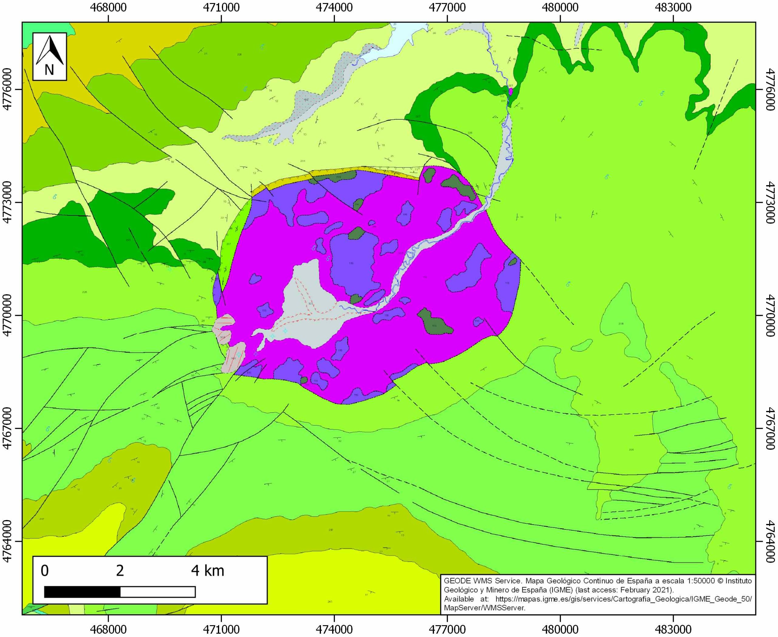
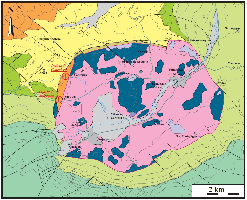
| Other comments | Northwest-southeast alignment (Las Losas fault; Martín-Chivelet et al., 2002) of the Murguía, Orduña, and Villasana de Mena diapirs. Pb-Zn mineralization hints at San Juan and Concejero zones (eastern contact of the diapir). Limestones and dolomites interbedded with the salt. |
Generic Data
| Unique ID | 14 |
| Name | Valle de Mena |
| Structure type | Evaporite diapir |
| Deformed/Undeformed | Deformed |
| Buried/Outcropping | Outcropping |
| Geological setting | Basque-Cantabrian Basin |
| Geological Regional Setting | Navarra-Álava trough |
| Evaporite unit/s name | Keuper facies |
| Evaporite unit/s age | Carnian-Rhaetian (Upper Triassic) |
| Evaporite unit/s era | Mesozoic |
| Evaporite unit/s origin | Marine |
| Evaporite unit/s composition | Gypsum-Halite-Anhydrite-Claystone-Ophites |
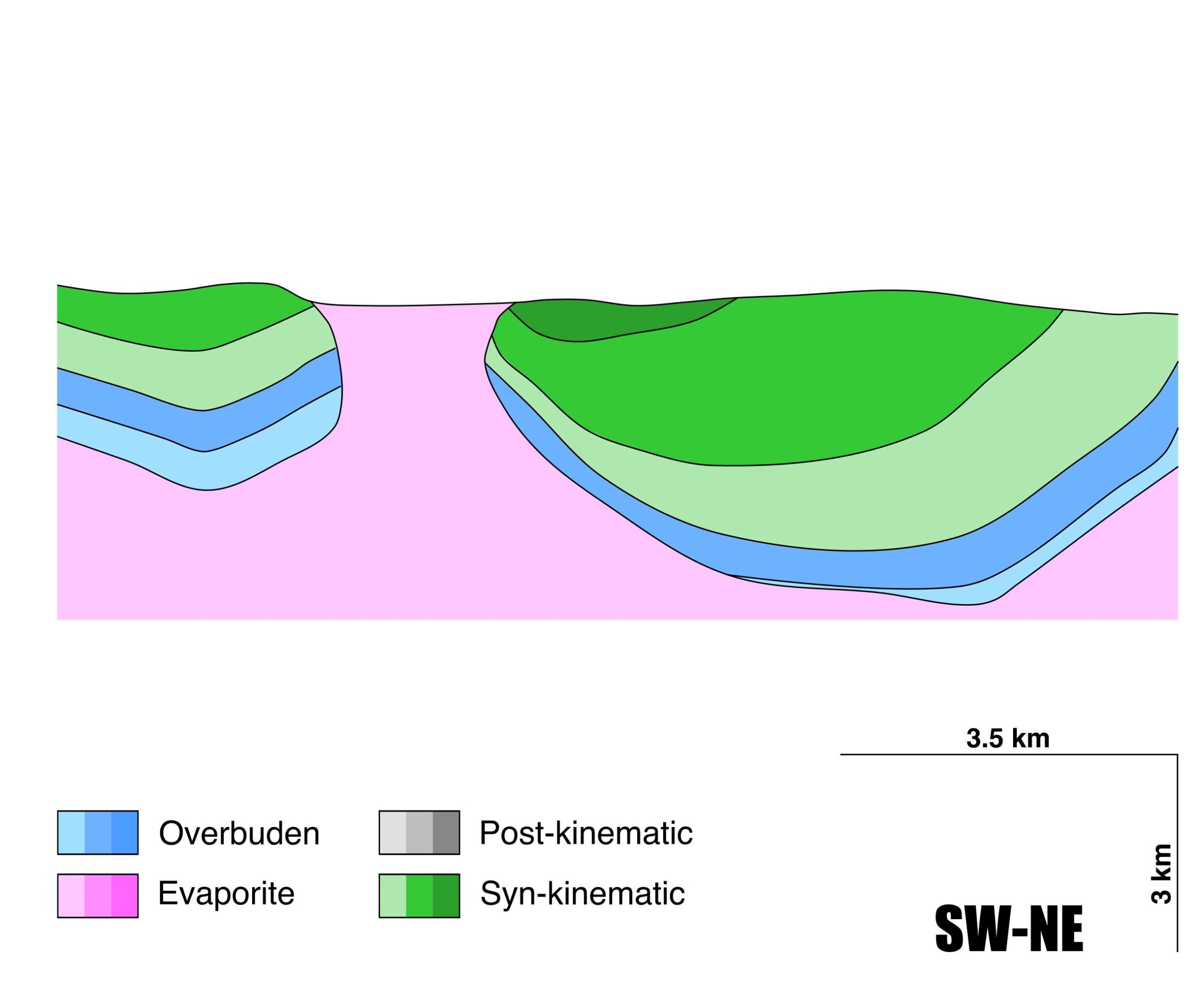
| Post-kinematic unit/s (or post-evaporite units when evaporites are undeformed) | Miocene (sandstones and conglomerates) / Quaternary (alluvial and colluvial detrital deposits) |
| Post-kinematic unit/s age (or post-evaporite units when evaporites are undeformed) | Miocene-Holocene |
| Classification (Hudec and Jackson, 2009) | Passive piercement |
| Classification (Jackson and Talbot, 1986) | Salt stock |
| Mining activity? | Y |
| Mining activity start | – |
| Mining activity end | – |
| Mining galleries? | – |
| Mining products | Ornamental limestone |
| Mining sub-products | – |
| Evaporite flow? | Y |
| Age of evaporite flow | Middle Cretaceous (early pillow-stage piercement) and Eocene (main stage) |
| Flow or deformation triggering mechanisms | Mesozoic extensional regime in the Basque–Cantabrian Basin (early stage) and Alpine compression and squeezing (late stage) |
| Flow-linked structures? | Y |
| Halokinetic structures | Radial joints and faults / Syncline-Anticline folding |
| Post-evaporite and pre-kinematic unit/s (overbuden) | Lower Jurassic (dolomitic brecchias, limestones and marls) |
| Syn-kinematic unit/s | Albo-Cenomanian (Valmaseda Fm.) / Cenomanian (marls and limestones) / Turonian (Gárate limestones Fm.) / Middle-Upper Turonian (Zuazo marls Fm.) / Lower Coniacian (Subijana limestones) / Palaeocene-Eocene (limestones, clays and marls) |
| Available seismic profiles | 13 / PR-59 / S82-15 / PR-59 / S-82-13 / S82-15 / PR-53 / PR-32-P / PR-58 / PR-52 / PR-40-P / 44243 / 13 / 18 / 44211 / 77 / 16 / 64 / 19 / 73 / 66 |
| Available boreholes | |
| Additional comments | Northwest-southeast alignment (Las Losas fault; Martín-Chivelet et al., 2002) of the Murguía, Orduña, and Villasana de Mena diapirs. Pb-Zn mineralization hints at San Juan and Concejero zones (eastern contact of the diapir). Limestones and dolomites interbedded with the salt. |
Mining Data
| UNIQUE_ID | 14 |
| Minning exploitations within <2km? | Y |
| Historical/Active | Active |
| Exploitation name #1 | UNGO NAVA-VIVANCO |
| Exploitation ID (Spanish National Mining Cadastre) #1 | 4147 |
| Municipality #1 | Valle de Mena |
| Province #1 | BURGOS |
| Company #1 | UNGO NAVA, SA |
| Main minning Products #1 | Ornamental limestone |
| Exploitation name #2 | |
| Exploitation ID (Spanish National Mining Cadastre) #2 | |
| Municipality #2 | |
| Province #2 | |
| Company #2 | |
| Main minning Products #2 | |
| Exploitation name #3 | |
| Exploitation ID (Spanish National Mining Cadastre) #3 | |
| Municipality #3 | |
| Province #3 | |
| Company #3 | |
| Main minning Products #3 |
Quantitative Data
| UNIQUE_ID | 14 |
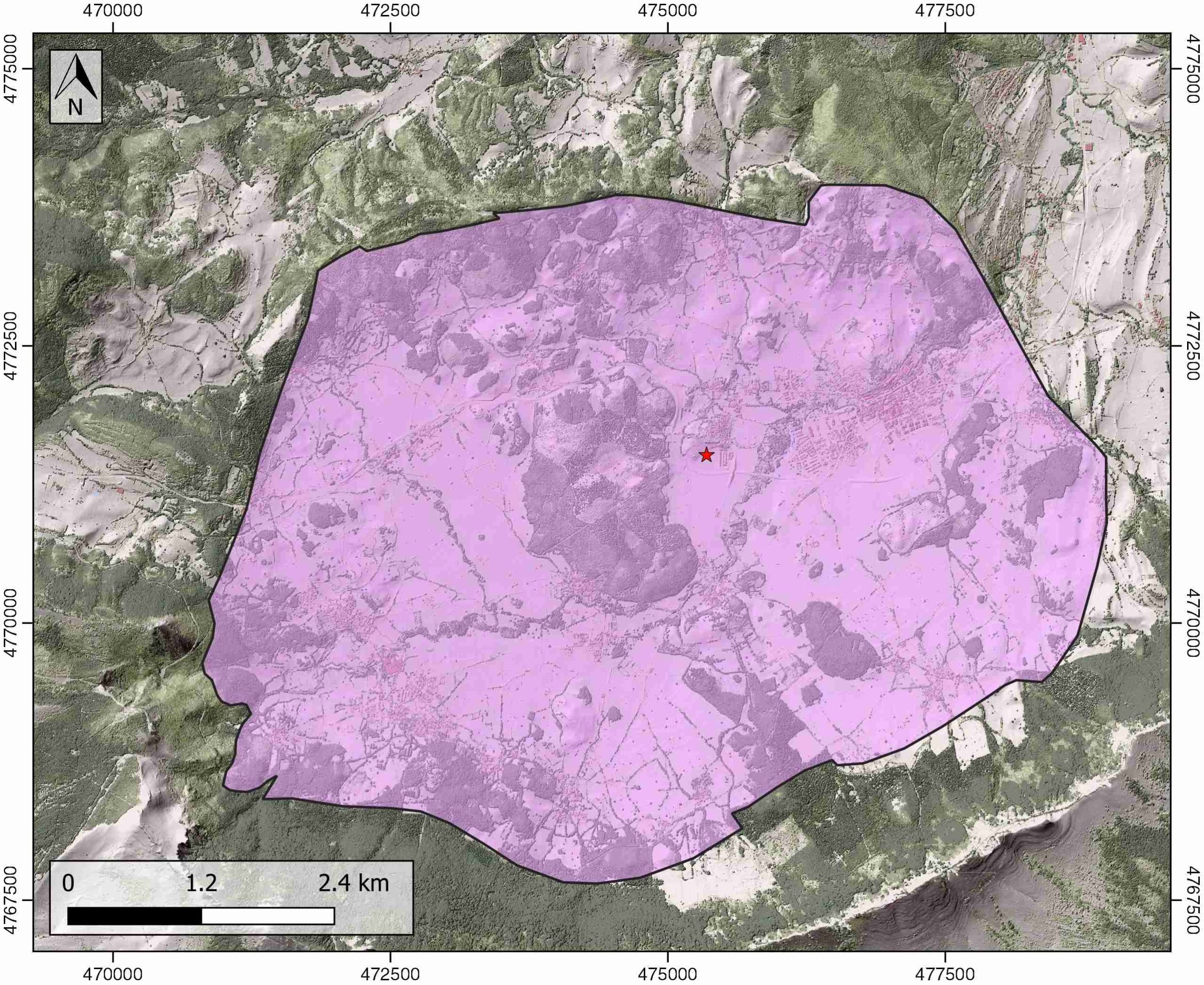
| Outcropping area (km2) | 38.03652 |
| Horizontal intersection area (km2) (when buried) | Not buried |
| Depth of intersection area (km2) (when buried) | Not buried |
| Max. Width (Km) | 6.1 |
| Max. Length (Km) | 8.3 |
| Max. Evaporites thickness (km) | 3 |
| Max. Deformation age (Ma) | 100 |
| Min. Deformation age (Ma) | 40 |
| Deformation stages | 2 |
Reference Data
| UNIQUE_ID | 14 |
| Section source | Poprawski, Y., Basile, C., 2018. Long-lasting diapir growth history in the Basque-Cantabrian basin (Northern Spain): a review. Conference poster, Advances in Salt Tectonics: Observations, Applications, and Perspective: In Honor of Martin P.A. Jackson. [link] |
| Well / Borehole availability #1 | Perona, J., 2016. Mineralizaciones de Pb-Zn asociadas a los diapiros de Murguía y Orduña (Cuenca Vasco-Cantábrica) [PhD thesis]: Barcelona, Universitat de Barcelona, 281 pp. [link] |
| Well / Borehole availability #2 | IGME MAGNA 50. SHEET 50 (VILLASANA DE MENA) Supplementary information. [link] |
| Available data (Stratigraphy) #1 | Perona, J., 2016. Mineralizaciones de Pb-Zn asociadas a los diapiros de Murguía y Orduña (Cuenca Vasco-Cantábrica) [PhD thesis]: Barcelona, Universitat de Barcelona, 281 pp. [link] |
| Available data (Stratigraphy) #2 | Serrano, A., Martínez del Olmo, W., Cámara, P., 1989. Diapirismo del Trías salino en el dominio Cántabro-Navarro. Libro homenaje a Rafael Soler: Madrid, Asociación de Geólogos y Geofísicos Españoles del Petróleo, p. 115–121. |
| Available data (Stratigraphy) #3 | García-Mondéjar, J., López-Horgue, M.A., Aranburu, A., Fernández-Mendiola, P.A., 2005. Pulsating subsidence during a rift episode: Stratigraphic and tectonic consequences (Aptian-Albian, northern Spain). Terra Nova, 17, 517–525. [link] |
| Available data (Stratigraphy) #4 | Reitner, J., 1986. A comparative study of the diagenesis in diapir-influenced reef atolls and a fault block reef platform in the Late Albian of the Vasco-Cantabrian Basin (Northern Spain). In Reef diagenesis (pp. 186-209). Springer, Berlin, Heidelberg. [link] |
| Available data (Stratigraphy) #5 | Ábalos, B., Alonso, N., Berrocal, T., Furundarena, A., Gorospe, I., Martínez-Escauriaza, G., Matxain, I., Sánchez-Lorda, M.E., 2003. Análisis estructural de los surcos periféricos del diapiro de Murguía (Álava, Cuenca Vasco-Cantábrica). Geogaceta, 34, 7–10. [link] |
| Available data (Stratigraphy) #6 | Cámara, P., 2017. Salt and Strike-Slip Tectonics as Main Drivers in the Structural Evolution of the Basque-Cantabrian Basin, Spain. In Permo-Triassic Salt Provinces of Europe, North Africa and the Atlantic Margins (pp. 371-393). Elsevier. [link] |
| Regional Stratigraphy | Pedrera, A., García‐Senz, J., Ayala, C., Ruiz‐Constán, A., Rodríguez‐Fernández, L. R., Robador, A., González Menéndez, L., 2017. Reconstruction of the exhumed mantle across the North Iberian Margin by crustal‐scale 3‐D gravity inversion and geological cross section. Tectonics, 36, 3155-3177. [link] |
| Seismic data availability #1 | Pedrera, A., García‐Senz, J., Ayala, C., Ruiz‐Constán, A., Rodríguez‐Fernández, L. R., Robador, A., González Menéndez, L., 2017. Reconstruction of the exhumed mantle across the North Iberian Margin by crustal‐scale 3‐D gravity inversion and geological cross section. Tectonics, 36, 3155-3177. [link] |
| Seismic data availability #2 | Poprawski, Y., Basile, C., 2018. Long-lasting diapir growth history in the Basque-Cantabrian basin (Northern Spain): a review. Conference poster, Advances in Salt Tectonics: Observations, Applications, and Perspective: In Honor of Martin P.A. Jackson. [link] |
| Seismic data availability #3 | n.a. |
| Available data (Structure) #1 | Fernández-Mendiola, P. A., García-Mondéjar, J., 1997. Isolated carbonate platform of Caniego, Spain: a test of the latest Albian worldwide sea-level changes. Geological Society of America Bulletin, 109(2), 176-194. [link] |
| Available data (Structure) #2 | Poprawski, Y., Basile, C., 2018. Long-lasting diapir growth history in the Basque-Cantabrian basin (Northern Spain): a review. Conference poster, Advances in Salt Tectonics: Observations, Applications, and Perspective: In Honor of Martin P.A. Jackson. [link] |
| Available data (Structure) #3 | García‐Mondéjar, J., Agirrezabala, L. M., Aranburu, A., Fernández‐Mendiola, P. A., Gómez‐Pérez, I., López‐Horgue, M., Rosales, I., 1996. Aptian—Albian tectonic pattern of the Basque—Cantabrian Basin (Northern Spain). Geological Journal, 31(1), 13-45. [link] |
| Available data (Structure) #4 | Rat, P., 1988. The Basque-Cantabrian basin between the Iberian and European plates; some facts but still many problems. Revista de la Sociedad Geológica de España, 1, 327–348. [link] |
| Available data (Structure) #5 | Pedrera, A., García‐Senz, J., Ayala, C., Ruiz‐Constán, A., Rodríguez‐Fernández, L. R., Robador, A., González Menéndez, L., 2017. Reconstruction of the exhumed mantle across the North Iberian Margin by crustal‐scale 3‐D gravity inversion and geological cross section. Tectonics, 36, 3155-3177. [link] |
| Available data (Structure) #6 | Cámara, P., 2017. Salt and Strike-Slip Tectonics as Main Drivers in the Structural Evolution of the Basque-Cantabrian Basin, Spain. In Permo-Triassic Salt Provinces of Europe, North Africa and the Atlantic Margins (pp. 371-393). Elsevier. [link] |
| Available data (Analogue modelling) #1 | n.a. |
| Available data (Analogue modelling) #2 | n.a. |
| Available data (Analogue modelling) #3 | n.a. |
| Available data (Gravimetry – Tomography) #1 | Nettleton, L.L., 1968. Gravity anomalies over salt diapirs, northern Spain. Geological Society of America Special Papers, 88, 75–82. [link] |
| Available data (Gravimetry – Tomography) #2 | Pedrera, A., García‐Senz, J., Ayala, C., Ruiz‐Constán, A., Rodríguez‐Fernández, L. R., Robador, A., González Menéndez, L., 2017. Reconstruction of the exhumed mantle across the North Iberian Margin by crustal‐scale 3‐D gravity inversion and geological cross section. Tectonics, 36, 3155-3177. [link] |
| Available data (Gravimetry – Tomography) #3 | Pinto, V., Casas, A., Rivero, L., Torné, M., 2005. 3D gravity modeling of the Triassic salt diapirs of the Cubeta Alavesa (northern Spain). Tectonophysics, 405, 65-75. [link] |
| Available data (Geochemistry) #1 | Iribar, V., Ábalos, B. 2011. The geochemical and isotopic record of evaporite recycling in spas and salterns of the Basque Cantabrian basin, Spain. Applied geochemistry, 26, 1315-1329. [link] |
| Available data (Geochemistry) #2 | Perona, J., Canals, À., Cardellach, E., 2018. Zn-Pb mineralization associated with salt diapirs in the basque-cantabrian Basin, Northern Spain. Geology, geochemistry, and genetic model. Economic Geology, 113, 1133-1159. [link] |
| Available data (Geochemistry) #3 | Perona, J., 2016. Mineralizaciones de Pb-Zn asociadas a los diapiros de Murguía y Orduña (Cuenca Vasco-Cantábrica) [PhD thesis]: Barcelona, Universitat de Barcelona, 281 pp. [link] |
| Available data (Geochemistry) #4 | Reitner, J., 1986. A comparative study of the diagenesis in diapir-influenced reef atolls and a fault block reef platform in the Late Albian of the Vasco-Cantabrian Basin (Northern Spain). In Reef diagenesis (pp. 186-209). Springer, Berlin, Heidelberg. [link] |
| Available data (Petrophysics) #1 | Llamas, B., Castañeda, M. C., Laín, C., Pous, J., 2017. Study of the Basque–Cantabrian basin as a suitable region for the implementation of an energy storage system based on compressed air energy storage (CAES). Environmental Earth Sciences, 76(5), 204. [link] |
| Available data (Petrophysics) #2 | n.a. |
| IGME Geological Map (MAGNA50) Sheet number | 85-Villasana de Mena. [link] |
| Other Maps #1 (source) | Perona, J., 2016. Mineralizaciones de Pb-Zn asociadas a los diapiros de Murguía y Orduña (Cuenca Vasco-Cantábrica) [PhD thesis]: Barcelona, Universitat de Barcelona, 281 pp. [link] |
| Other Maps #2 (source) | Perona, J., 2016. Mineralizaciones de Pb-Zn asociadas a los diapiros de Murguía y Orduña (Cuenca Vasco-Cantábrica) [PhD thesis]: Barcelona, Universitat de Barcelona, 281 pp. [link] |
| Other related references #1 | Sanz, T., Lago, M., Gil, A., Galé, C., Ramajo, J., Ubide, T., Pocoví, A., Tierz, P., Larrea, P., 2013. The Upper Triassic alkaline magmatism in the NW Iberian Chain (Spain). Journal of Iberian Geology, 39, 202-222. [link] |
| Other related references #2 | Cámara, P., 2020. Inverted turtle salt anticlines in the eastern basque-cantabrian basin, Spain. Marine and Petroleum Geology, 104358. [link] |
| Other related references #3 | Ruiz, M., Díaz, J., Gallart, J., Pulgar, J.A., González-Cortina, J.M., López, C., 2006. Seismotectonic constraints at the western edge of the Pyrenees: aftershock series monitoring of the 2002 February 21, 4.1 Lg earthquake. Geophysical Journal International, 166, 238–252. [link] |
| Other related references #4 | Ruiz, M., Gallart, J., Díaz, J., Olivera, C., Pedreira, D., López, C., González-Cortina, J.M., Pulgar, J.A., 2006. Seismic activity at the western Pyrenean edge. Tectonophysics, 412, 217–235. [link] |
Well and Seismic Data
| UNIQUE_ID | 14 |
| Seismic survey name #1 | 7C-ST-98-98BIS |
| Across structure? #1 | Y |
| Seismic profile ID (IGME) #1 | 12929 |
| Seismic profile code #1 | 17647 |
| Seismic profile name #1 | 13 |
| Seismic survey year #1 | 1961 |
| Data repository #1 | SIGEOF Data Catalogue (Private access section). ©Instituto Geológico y Minero de España (IGME). https://info.igme.es/SIGEOF/ |
| Length (km) #1 | 13.48 |
| Seismic survey name #2 | 7C1-PR |
| Across structure? #2 | Y |
| Seismic profile ID (IGME) #2 | 9432 |
| Seismic profile code #2 | 14005 |
| Seismic profile name #2 | PR-59 |
| Seismic survey year #2 | 1978 |
| Data repository #2 | SIGEOF Data Catalogue (Section available under request). ©Instituto Geológico y Minero de España (IGME). https://info.igme.es/SIGEOF/ |
| Length (km) #2 | 15.13 |
| Seismic survey name #3 | 7C1-S82 |
| Across structure? #3 | Y |
| Seismic profile ID (IGME) #3 | 9455 |
| Seismic profile code #3 | 14028 |
| Seismic profile name #3 | S82-15 |
| Seismic survey year #3 | 1982 |
| Data repository #3 | SIGEOF Data Catalogue (Section available under request). ©Instituto Geológico y Minero de España (IGME). https://info.igme.es/SIGEOF/ |
| Length (km) #3 | 4.13 |
| Seismic survey name #4 | 7C1-PR |
| Across structure? #4 | N (within 3km) |
| Seismic profile ID (IGME) #4 | 9432 |
| Seismic profile code #4 | 14005 |
| Seismic profile name #4 | PR-59 |
| Seismic survey year #4 | 1978 |
| Data repository #4 | SIGEOF Data Catalogue (Section available under request). ©Instituto Geológico y Minero de España (IGME). https://info.igme.es/SIGEOF/ |
| Length (km) #4 | 15.13 |
| Seismic survey name #5 | 7C1-S82 |
| Across structure? #5 | N (within 3km) |
| Seismic profile ID (IGME) #5 | 9457 |
| Seismic profile code #5 | 14030 |
| Seismic profile name #5 | S-82-13 |
| Seismic survey year #5 | 1982 |
| Data repository #5 | SIGEOF Data Catalogue (Section available under request). ©Instituto Geológico y Minero de España (IGME). https://info.igme.es/SIGEOF/ |
| Length (km) #5 | 27.42 |
| Seismic survey name #6 | 7C1-S82 |
| Across structure? #6 | N (within 3km) |
| Seismic profile ID (IGME) #6 | 9455 |
| Seismic profile code #6 | 14028 |
| Seismic profile name #6 | S82-15 |
| Seismic survey year #6 | 1982 |
| Data repository #6 | SIGEOF Data Catalogue (Section available under request). ©Instituto Geológico y Minero de España (IGME). https://info.igme.es/SIGEOF/ |
| Length (km) #6 | 4.13 |
| Seismic survey name #7 | 7C1-PR |
| Across structure? #7 | N (within 3km) |
| Seismic profile ID (IGME) #7 | 9437 |
| Seismic profile code #7 | 14010 |
| Seismic profile name #7 | PR-53 |
| Seismic survey year #7 | 1978 |
| Data repository #7 | SIGEOF Data Catalogue (Section available under request). ©Instituto Geológico y Minero de España (IGME). https://info.igme.es/SIGEOF/ |
| Length (km) #7 | 32.16 |
| Seismic survey name #8 | 7C1-PR |
| Across structure? #8 | N (within 3km) |
| Seismic profile ID (IGME) #8 | 9448 |
| Seismic profile code #8 | 14021 |
| Seismic profile name #8 | PR-32-P |
| Seismic survey year #8 | 1978 |
| Data repository #8 | SIGEOF Data Catalogue (Section available under request). ©Instituto Geológico y Minero de España (IGME). https://info.igme.es/SIGEOF/ |
| Length (km) #8 | 16.03 |
| Seismic survey name #9 | 7C1-PR |
| Across structure? #9 | N (within 3km) |
| Seismic profile ID (IGME) #9 | 9433 |
| Seismic profile code #9 | 14006 |
| Seismic profile name #9 | PR-58 |
| Seismic survey year #9 | 1978 |
| Data repository #9 | SIGEOF Data Catalogue (Section available under request). ©Instituto Geológico y Minero de España (IGME). https://info.igme.es/SIGEOF/ |
| Length (km) #9 | 11.96 |
| Seismic survey name #10 | 7C1-PR |
| Across structure? #10 | N (within 3km) |
| Seismic profile ID (IGME) #10 | 9438 |
| Seismic profile code #10 | 14011 |
| Seismic profile name #10 | PR-52 |
| Seismic survey year #10 | 1978 |
| Data repository #10 | SIGEOF Data Catalogue (Section available under request). ©Instituto Geológico y Minero de España (IGME). https://info.igme.es/SIGEOF/ |
| Length (km) #10 | 10.01 |
| Seismic survey name #11 | 7C1-PR |
| Across structure? #11 | N (within 3km) |
| Seismic profile ID (IGME) #11 | 9443 |
| Seismic profile code #11 | 14016 |
| Seismic profile name #11 | PR-40-P |
| Seismic survey year #11 | 1978 |
| Data repository #11 | SIGEOF Data Catalogue (Section available under request). ©Instituto Geológico y Minero de España (IGME). https://info.igme.es/SIGEOF/ |
| Length (km) #11 | 12.47 |
| Seismic survey name #12 | 7C-ST-98-98BIS |
| Across structure? #12 | N (within 3km) |
| Seismic profile ID (IGME) #12 | 12920 |
| Seismic profile code #12 | 17638 |
| Seismic profile name #12 | 44243 |
| Seismic survey year #12 | 1961 |
| Data repository #12 | SIGEOF Data Catalogue (Private access section). ©Instituto Geológico y Minero de España (IGME). https://info.igme.es/SIGEOF/ |
| Length (km) #12 | 3.78 |
| Seismic survey name #13 | 7C-ST-98-98BIS |
| Across structure? #13 | N (within 3km) |
| Seismic profile ID (IGME) #13 | 12929 |
| Seismic profile code #13 | 17647 |
| Seismic profile name #13 | 13 |
| Seismic survey year #13 | 1961 |
| Data repository #13 | SIGEOF Data Catalogue (Private access section). ©Instituto Geológico y Minero de España (IGME). https://info.igme.es/SIGEOF/ |
| Length (km) #13 | 13.48 |
| Seismic survey name #14 | 7C-ST-98-98BIS |
| Across structure? #14 | N (within 3km) |
| Seismic profile ID (IGME) #14 | 12917 |
| Seismic profile code #14 | 17635 |
| Seismic profile name #14 | 18 |
| Seismic survey year #14 | 1961 |
| Data repository #14 | SIGEOF Data Catalogue (Private access section). ©Instituto Geológico y Minero de España (IGME). https://info.igme.es/SIGEOF/ |
| Length (km) #14 | 4.99 |
| Seismic survey name #15 | 7C-ST-98-98BIS |
| Across structure? #15 | N (within 3km) |
| Seismic profile ID (IGME) #15 | 12924 |
| Seismic profile code #15 | 17642 |
| Seismic profile name #15 | 44211 |
| Seismic survey year #15 | 1961 |
| Data repository #15 | SIGEOF Data Catalogue (Private access section). ©Instituto Geológico y Minero de España (IGME). https://info.igme.es/SIGEOF/ |
| Length (km) #15 | 5.24 |
| Seismic survey name #16 | 7C-ST-98-98BIS |
| Across structure? #16 | N (within 3km) |
| Seismic profile ID (IGME) #16 | 12882 |
| Seismic profile code #16 | 17600 |
| Seismic profile name #16 | 77 |
| Seismic survey year #16 | 1961 |
| Data repository #16 | SIGEOF Data Catalogue (Private access section). ©Instituto Geológico y Minero de España (IGME). https://info.igme.es/SIGEOF/ |
| Length (km) #16 | 2.48 |
| Seismic survey name #17 | 7C-ST-98-98BIS |
| Across structure? #17 | N (within 3km) |
| Seismic profile ID (IGME) #17 | 12922 |
| Seismic profile code #17 | 17640 |
| Seismic profile name #17 | 16 |
| Seismic survey year #17 | 1961 |
| Data repository #17 | SIGEOF Data Catalogue (Private access section). ©Instituto Geológico y Minero de España (IGME). https://info.igme.es/SIGEOF/ |
| Length (km) #17 | 16.45 |
| Seismic survey name #18 | 7C-ST-98 |
| Across structure? #18 | N (within 3km) |
| Seismic profile ID (IGME) #18 | 12859 |
| Seismic profile code #18 | 17577 |
| Seismic profile name #18 | 64 |
| Seismic survey year #18 | 1961 |
| Data repository #18 | SIGEOF Data Catalogue (Private access section). ©Instituto Geológico y Minero de España (IGME). https://info.igme.es/SIGEOF/ |
| Length (km) #18 | 2.76 |
| Seismic survey name #19 | 7C-ST-87 |
| Across structure? #19 | N (within 3km) |
| Seismic profile ID (IGME) #19 | 12725 |
| Seismic profile code #19 | 17443 |
| Seismic profile name #19 | 19 |
| Seismic survey year #19 | 1962 |
| Data repository #19 | SIGEOF Data Catalogue (Private access section). ©Instituto Geológico y Minero de España (IGME). https://info.igme.es/SIGEOF/ |
| Length (km) #19 | 22.66 |
| Seismic survey name #20 | 7C-ST-98-98BIS |
| Across structure? #20 | N (within 3km) |
| Seismic profile ID (IGME) #20 | 12885 |
| Seismic profile code #20 | 17603 |
| Seismic profile name #20 | 73 |
| Seismic survey year #20 | 1961 |
| Data repository #20 | SIGEOF Data Catalogue (Private access section). ©Instituto Geológico y Minero de España (IGME). https://info.igme.es/SIGEOF/ |
| Length (km) #20 | 8.53 |
| Seismic survey name #21 | 7C-ST-98-98BIS |
| Across structure? #21 | N (within 3km) |
| Seismic profile ID (IGME) #21 | 12892 |
| Seismic profile code #21 | 17610 |
| Seismic profile name #21 | 66 |
| Seismic survey year #21 | 1961 |
| Data repository #21 | SIGEOF Data Catalogue (Private access section). ©Instituto Geológico y Minero de España (IGME). https://info.igme.es/SIGEOF/ |
| Length (km) #21 | 2.29 |
| Borehole name #1 | |
| Company #1 | |
| Traget #1 | |
| Across structure? #1 | |
| Borehole name #2 | |
| Company #2 | |
| Traget #2 | |
| Across structure? #2 | |
| Borehole name #3 | |
| Company #3 | |
| Traget #3 | |
| Across structure? #3 | |
| Borehole name #4 | |
| Company #4 | |
| Traget #4 | |
| Across structure? #4 | |
| Borehole name #5 | |
| Company #5 | |
| Traget #5 | |
| Across structure? #5 | |
| Borehole name #6 | |
| Company #6 | |
| Traget #6 | |
| Across structure? #6 | |
| Borehole name #7 | |
| Company #7 | |
| Traget #7 | |
| Across structure? #7 | |
| Borehole name #8 | |
| Company #8 | |
| Traget #8 | |
| Across structure? #8 | |
| Borehole name #9 | |
| Company #9 | |
| Traget #9 | |
| Across structure? #9 | |
| Borehole name #10 | |
| Company #10 | |
| Traget #10 | |
| Across structure? #10 | |
| Borehole name #11 | |
| Company #11 | |
| Traget #11 | |
| Across structure? #11 | |
| Borehole name #12 | |
| Company #12 | |
| Traget #12 | |
| Across structure? #12 | |
| Borehole name #13 | |
| Company #13 | |
| Traget #13 | |
| Across structure? #13 | |
| Borehole name #14 | |
| Company #14 | |
| Traget #14 | |
| Across structure? #14 | |
| Borehole name #15 | |
| Company #15 | |
| Traget #15 | |
| Across structure? #15 |
Geographical Data (EPSG:4326 - WGS 84)
| UNIQUE_ID | 14 |
| X Centroid (Structure shape) | -3.309729 |
| Y Centroid (Structure shape) | -3.309729 |
| Xmin (Structure shape) | -3.358670 |
| Xmax (Structure shape) | -3.258554 |
| Ymin (Structure shape) | 43.061098 |
| Ymax (Structure shape) | 43.117951 |
| Xmin seismic line #1 | -3.347579 |
| Xmax seismic line #1 | -3.329304 |
| Ymin seismic line #1 | 42.992581 |
| Ymax seismic line #1 | 43.088386 |
| Xmin seismic line #2 | -3.527843 |
| Xmax seismic line #2 | -3.342469 |
| Ymin seismic line #2 | 43.089174 |
| Ymax seismic line #2 | 43.093092 |
| Xmin seismic line #3 | -3.307971 |
| Xmax seismic line #3 | -3.278308 |
| Ymin seismic line #3 | 43.063712 |
| Ymax seismic line #3 | 43.093911 |
| Xmin seismic line #4 | -3.527843 |
| Xmax seismic line #4 | -3.342469 |
| Ymin seismic line #4 | 43.089174 |
| Ymax seismic line #4 | 43.093092 |
| Xmin seismic line #5 | -3.257925 |
| Xmax seismic line #5 | -2.974246 |
| Ymin seismic line #5 | 42.925233 |
| Ymax seismic line #5 | 43.055700 |
| Xmin seismic line #6 | -3.307971 |
| Xmax seismic line #6 | -3.278308 |
| Ymin seismic line #6 | 43.063712 |
| Ymax seismic line #6 | 43.093911 |
| Xmin seismic line #7 | -3.498104 |
| Xmax seismic line #7 | -3.154630 |
| Ymin seismic line #7 | 42.947871 |
| Ymax seismic line #7 | 43.071846 |
| Xmin seismic line #8 | -3.441599 |
| Xmax seismic line #8 | -3.357385 |
| Ymin seismic line #8 | 42.982262 |
| Ymax seismic line #8 | 43.111993 |
| Xmin seismic line #9 | -3.500381 |
| Xmax seismic line #9 | -3.369278 |
| Ymin seismic line #9 | 43.045382 |
| Ymax seismic line #9 | 43.093646 |
| Xmin seismic line #10 | -3.401212 |
| Xmax seismic line #10 | -3.352003 |
| Ymin seismic line #10 | 42.965598 |
| Ymax seismic line #10 | 43.047580 |
| Xmin seismic line #11 | -3.392022 |
| Xmax seismic line #11 | -3.302528 |
| Ymin seismic line #11 | 42.956967 |
| Ymax seismic line #11 | 43.043795 |
| Xmin seismic line #12 | -3.416489 |
| Xmax seismic line #12 | -3.384120 |
| Ymin seismic line #12 | 43.070763 |
| Ymax seismic line #12 | 43.094865 |
| Xmin seismic line #13 | -3.347579 |
| Xmax seismic line #13 | -3.329304 |
| Ymin seismic line #13 | 42.992581 |
| Ymax seismic line #13 | 43.088386 |
| Xmin seismic line #14 | -3.407184 |
| Xmax seismic line #14 | -3.356843 |
| Ymin seismic line #14 | 43.027316 |
| Ymax seismic line #14 | 43.052211 |
| Xmin seismic line #15 | -3.419202 |
| Xmax seismic line #15 | -3.365536 |
| Ymin seismic line #15 | 43.032945 |
| Ymax seismic line #15 | 43.058235 |
| Xmin seismic line #16 | -3.410740 |
| Xmax seismic line #16 | -3.383530 |
| Ymin seismic line #16 | 43.105677 |
| Ymax seismic line #16 | 43.110243 |
| Xmin seismic line #17 | -3.380764 |
| Xmax seismic line #17 | -3.200734 |
| Ymin seismic line #17 | 43.012618 |
| Ymax seismic line #17 | 43.066299 |
| Xmin seismic line #18 | -3.389646 |
| Xmax seismic line #18 | -3.358052 |
| Ymin seismic line #18 | 43.089182 |
| Ymax seismic line #18 | 43.097868 |
| Xmin seismic line #19 | -3.476627 |
| Xmax seismic line #19 | -3.235131 |
| Ymin seismic line #19 | 43.079169 |
| Ymax seismic line #19 | 43.161727 |
| Xmin seismic line #20 | -3.468445 |
| Xmax seismic line #20 | -3.385009 |
| Ymin seismic line #20 | 43.045065 |
| Ymax seismic line #20 | 43.081431 |
| Xmin seismic line #21 | -3.332597 |
| Xmax seismic line #21 | -3.318612 |
| Ymin seismic line #21 | 43.124895 |
| Ymax seismic line #21 | 43.142153 |
| X borehole #1 | |
| Y borehole #1 | |
| X borehole #2 | |
| Y borehole #2 | |
| X borehole #3 | |
| Y borehole #3 | |
| X borehole #4 | |
| Y borehole #4 | |
| X borehole #5 | |
| Y borehole #5 | |
| X borehole #6 | |
| Y borehole #6 | |
| X borehole #7 | |
| Y borehole #7 | |
| X borehole #8 | |
| Y borehole #8 | |
| X borehole #9 | |
| Y borehole #9 | |
| X borehole #10 | |
| Y borehole #10 | |
| X borehole #11 | |
| Y borehole #11 | |
| X borehole #12 | |
| Y borehole #12 | |
| X borehole #13 | |
| Y borehole #13 | |
| X borehole #14 | |
| Y borehole #14 | |
| X borehole #15 | |
| Y borehole #15 |

