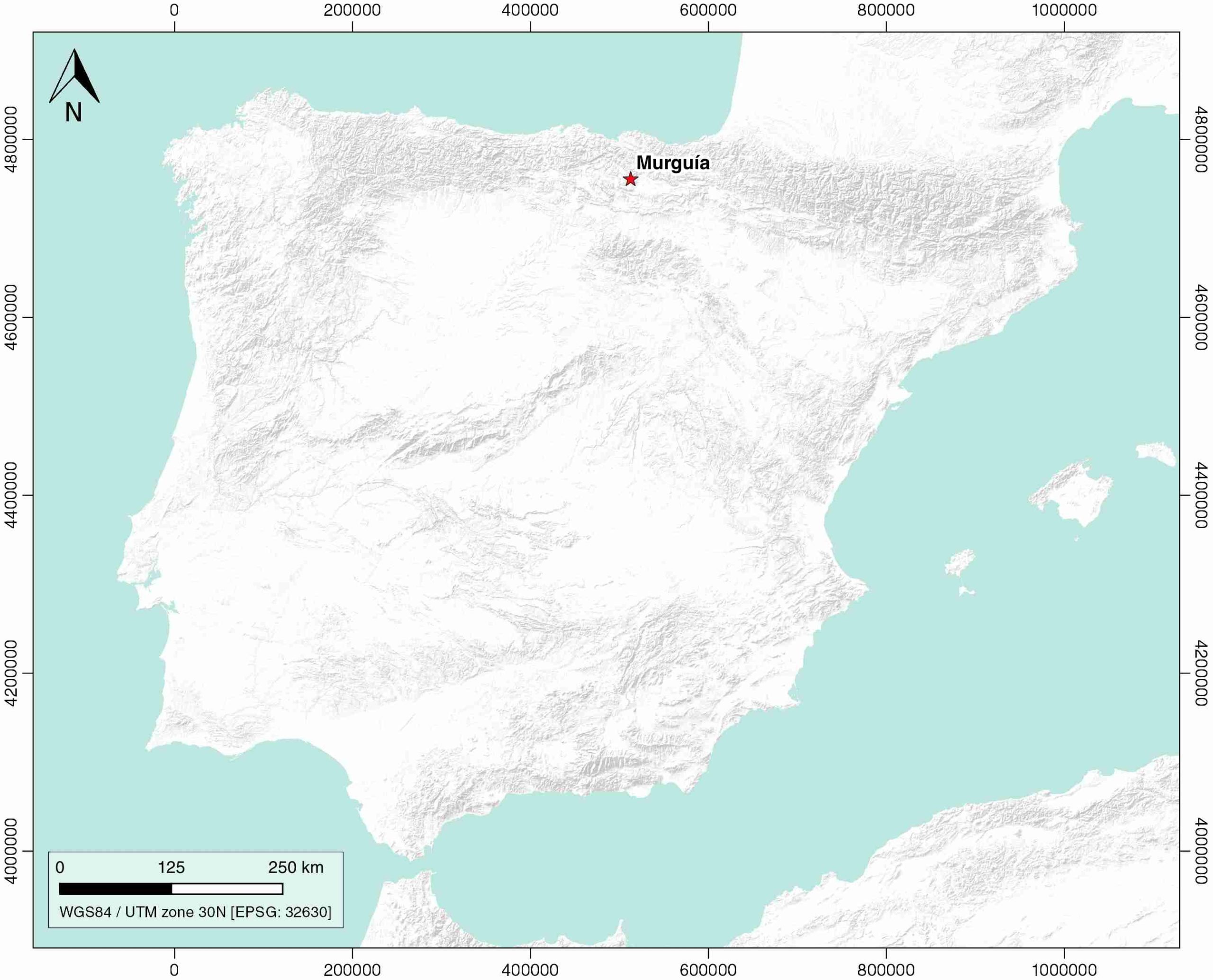
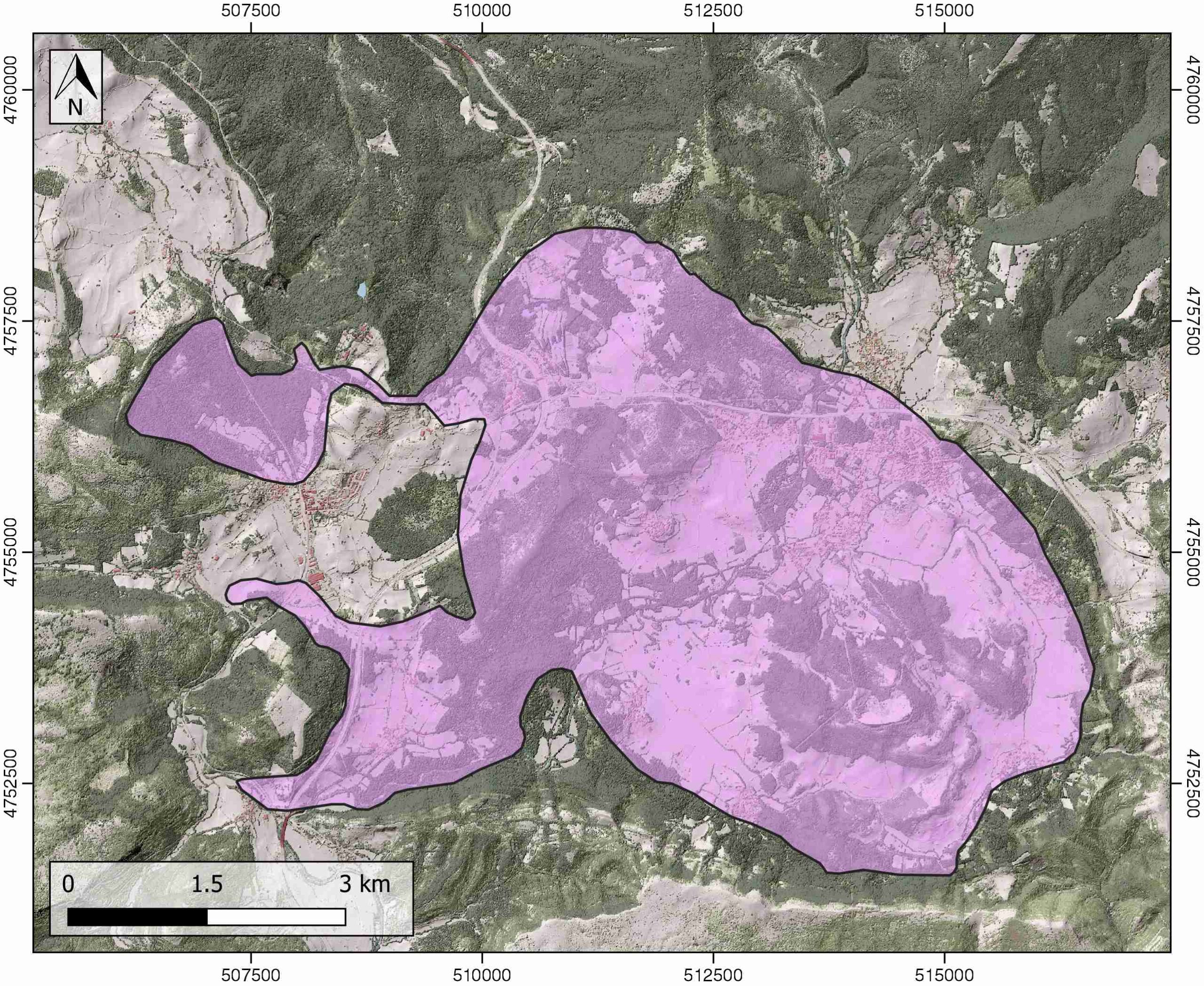
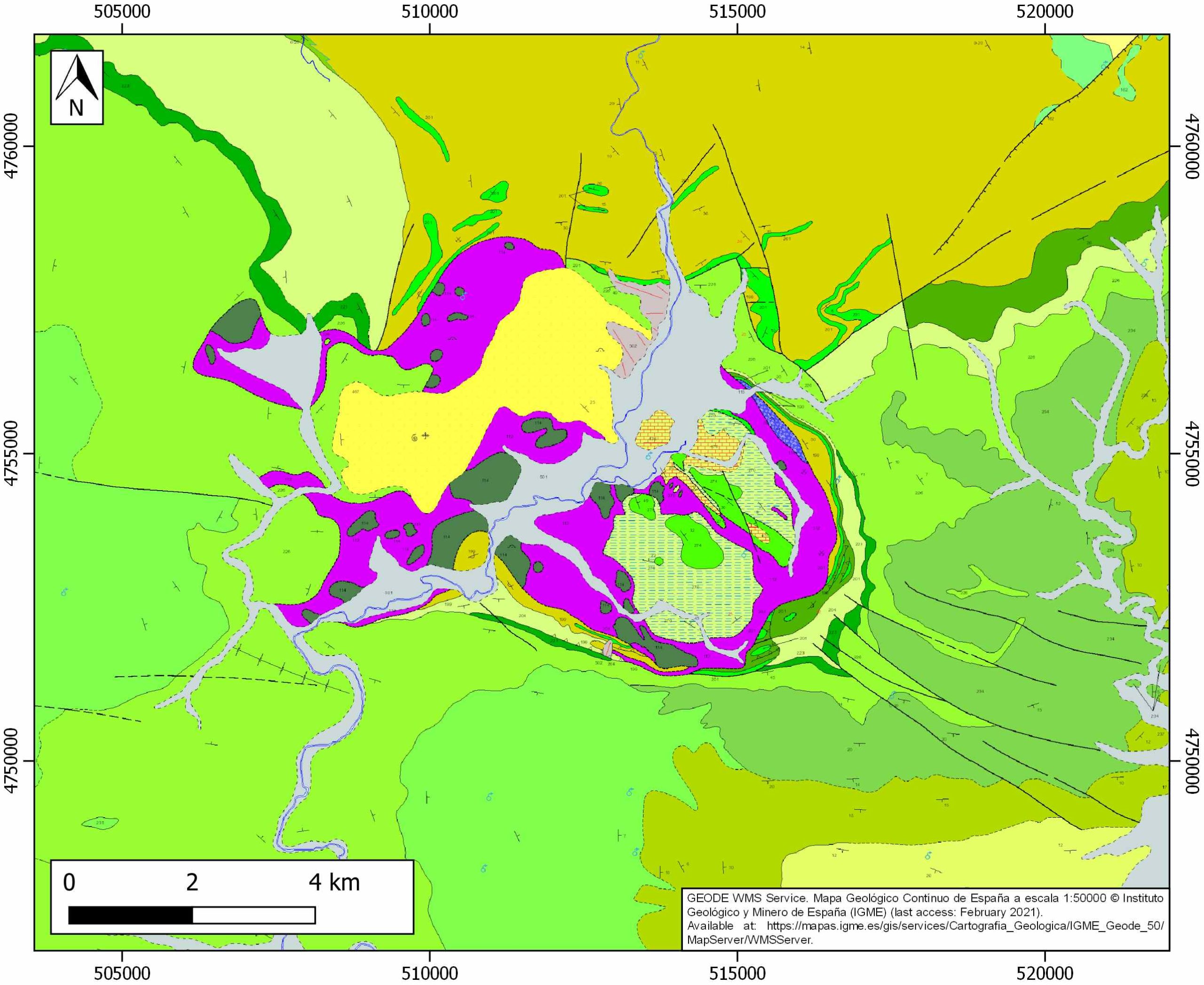
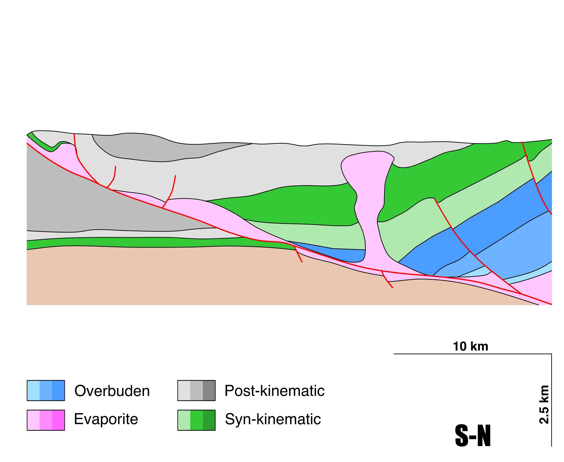
General Information
| Structure type | Evaporite Diapir |
| Deformed/Undeformed | Deformed |
| Geological Setting | Basque-Cantabrian Basin, Navarra-Álava trough |
| Outcropping/buried | Outcropping |
| Evaporite unit/s name | Keuper facies |
| Evaporite unit/s age | Carnian-Rhaetian (Upper Triassic) |
| Evaporite unit/s origin | Marine |
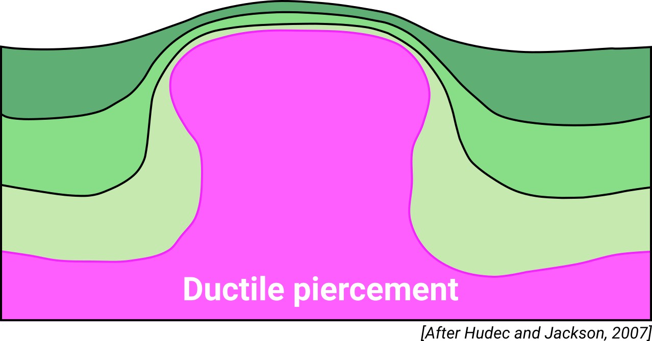
| Classif. (Hudec and Jackson, 2009) | Ductile piercement |
| Classif. (Jackson and Talbot, 1986) | Salt stock |
| Age of evaporite flow or deformation (when deformed) | Middle Cretaceous, Paleocene |
| Other comments | Northwest-southeast alignment (Las Losas fault; Martín-Chivelet et al., 2002) of the Murguía, Orduña, and Villasana de Mena diapirs. |
Generic Data
| Unique ID | 15 |
| Name | Murguia |
| Structure type | Evaporite diapir |
| Deformed/Undeformed | Deformed |
| Buried/Outcropping | Outcropping |
| Geological setting | Basque-Cantabrian Basin |
| Geological Regional Setting | Navarra-Álava trough |
| Evaporite unit/s name | Keuper facies |
| Evaporite unit/s age | Carnian-Rhaetian (Upper Triassic) |
| Evaporite unit/s era | Mesozoic |
| Evaporite unit/s origin | Marine |
| Evaporite unit/s composition | Gypsum-Halite-Anhydrite-Claystone-Ophites |
| Post-kinematic unit/s (or post-evaporite units when evaporites are undeformed) | Lower Oligocene (conglomerates and Sandstones) and Quaternary (alluvial and colluvial detrital deposits) |
| Post-kinematic unit/s age (or post-evaporite units when evaporites are undeformed) | Lower Oligocene and Quaternary |
| Classification (Hudec and Jackson, 2009) | Ductile piercement |
| Classification (Jackson and Talbot, 1986) | Salt stock |
| Mining activity? | Y |
| Mining activity start | 1996 |
| Mining activity end | 2000 |
| Mining galleries? | Y |
| Mining products | Pb-Zn |
| Mining sub-products | |
| Evaporite flow? | Y |
| Age of evaporite flow | Albian – Campanian (early stage) and Palaeocene (late stage) |
| Flow or deformation triggering mechanisms | Mesozoic extensional regime in the Basque–Cantabrian Basin (early stage) and Alpine compression (late stage) |
| Flow-linked structures? | Y |
| Halokinetic structures | Radial joints and faults / Syncline folding |
| Post-evaporite and pre-kinematic unit/s (overbuden) | Jurassic (dolomitic limestones, dolomitic brecchias and laminated dolostones) |
| Syn-kinematic unit/s | Albian (Valmaseda Fm.) |
| Available seismic profiles | S82-23 / S82-23 / ZU-2 / I-5 / I-6 / VA-11 / CC-3 / ZU-1 / D-8 / RV-5 / |
| Available boreholes | ANDAGOYA (ANDAGOIA-CUARTANGO) / ALTUBE-9 (ALT-9) / ALTUBE-6 (ALT-6) / ALTUBE-7 (ALT-7) / ALTUBE-2 (ALT-2) / ALTUBE-5 (ALT-5) / ALTUBE-3 (ALT-3) / ALTUBE-4 (ALT-4) / ALTUBE-8 (ALT-8) / BELUNZA-1 (BEL-1) / ALTUBE-1 (ALT-1) |
| Additional comments | Northwest-southeast alignment (Las Losas fault; Martín-Chivelet et al., 2002) of the Murguía, Orduña, and Villasana de Mena diapirs |
Mining Data
| UNIQUE_ID | 15 |
| Minning exploitations within <2km? | Y |
| Historical/Active | Historical (not indexed in the Spanish National Minning Cadastre) |
| Exploitation name #1 | n.a. |
| Exploitation ID (Spanish National Mining Cadastre) #1 | n.a. |
| Municipality #1 | n.a. |
| Province #1 | n.a. |
| Company #1 | n.a. |
| Main minning Products #1 | Pb-Zn |
| Exploitation name #2 | |
| Exploitation ID (Spanish National Mining Cadastre) #2 | |
| Municipality #2 | |
| Province #2 | |
| Company #2 | |
| Main minning Products #2 | |
| Exploitation name #3 | |
| Exploitation ID (Spanish National Mining Cadastre) #3 | |
| Municipality #3 | |
| Province #3 | |
| Company #3 | |
| Main minning Products #3 |
Quantitative Data
| UNIQUE_ID | 15 |
| Outcropping area (km2) | 38.20648 |
| Horizontal intersection area (km2) (when buried) | Not buried |
| Depth of intersection area (km2) (when buried) | Not buried |
| Max. Width (Km) | 6.7 |
| Max. Length (Km) | 10.7 |
| Max. Evaporites thickness (km) | 6 |
| Max. Deformation age (Ma) | 113 |
| Min. Deformation age (Ma) | 56 |
| Deformation stages | 2 |
Reference Data
| UNIQUE_ID | 15 |
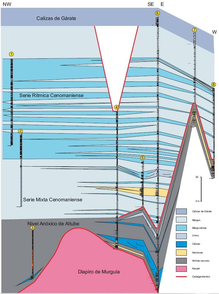
| Section source | Cámara, P., 2017. Salt and Strike-Slip Tectonics as Main Drivers in the Structural Evolution of the Basque-Cantabrian Basin, Spain. In Permo-Triassic Salt Provinces of Europe, North Africa and the Atlantic Margins (pp. 371-393). Elsevier. [link] |
| Well / Borehole availability #1 | Perona, J., 2016. Mineralizaciones de Pb-Zn asociadas a los diapiros de Murguía y Orduña (Cuenca Vasco-Cantábrica) [PhD thesis]: Barcelona, Universitat de Barcelona, 281 pp. [link] |
| Well / Borehole availability #2 | Pedrera, A., García‐Senz, J., Ayala, C., Ruiz‐Constán, A., Rodríguez‐Fernández, L. R., Robador, A., González Menéndez, L., 2017. Reconstruction of the exhumed mantle across the North Iberian Margin by crustal‐scale 3‐D gravity inversion and geological cross section. Tectonics, 36, 3155-3177. [link] |
| Available data (Stratigraphy) #1 | Perona, J., 2016. Mineralizaciones de Pb-Zn asociadas a los diapiros de Murguía y Orduña (Cuenca Vasco-Cantábrica) [PhD thesis]: Barcelona, Universitat de Barcelona, 281 pp. [link] |
| Available data (Stratigraphy) #2 | Serrano, A., Martínez del Olmo, W., Cámara, P., 1989. Diapirismo del Trías salino en el dominio Cántabro-Navarro. Libro homenaje a Rafael Soler: Madrid, Asociación de Geólogos y Geofísicos Españoles del Petróleo, p. 115–121. |
| Available data (Stratigraphy) #3 | Nettleton, L.L., 1968. Gravity anomalies over salt diapirs, northern Spain. Geological Society of America Special Papers, 88, 75–82. [link] |
| Available data (Stratigraphy) #4 | Serrano, A., Martínez del Olmo, W., 1990. Tectónica salina en el Dominio Cántabro-Navarro: Evolución, edad y origen de las estructuras salinas, in Ortí, F., and Salvany, J.M., (eds.), Formaciones evaporíticas de la Cuenca del Ebro y cadenas periféricas, y de la zona de Levante. Barcelona, ENRESA. [link] |
| Available data (Stratigraphy) #5 | García-Mondéjar, J., López-Horgue, M.A., Aranburu, A., Fernández-Mendiola, P.A., 2005. Pulsating subsidence during a rift episode: Stratigraphic and tectonic consequences (Aptian-Albian, northern Spain). Terra Nova, 17, 517–525. [link] |
| Available data (Stratigraphy) #6 | Frankovic, A., Eguiluz, L., Martínez-Torres, L.M., 2016. Geodynamic evolution of the Salinas de Añana diapir in the Basque-Cantabrian basin, western Pyrenees. Journal of Structural Geology, 83, 13–27. [link] |
| Regional Stratigraphy | Perona, J., 2016. Mineralizaciones de Pb-Zn asociadas a los diapiros de Murguía y Orduña (Cuenca Vasco-Cantábrica) [PhD thesis]: Barcelona, Universitat de Barcelona, 281 pp. [link] |
| Seismic data availability #1 | Roca, E., Muñoz, J.A., Ferrer, O., Ellouz, N., 2011. The role of the Bay of Biscay Mesozoic extensional structure in the configuration of the Pyrenean orogen: Constraints from the MARCONI deep seismic reflection survey. Tectonics, 30, 2. [link] |
| Seismic data availability #2 | [Private access]: CGS, 1996. Cartografía geológico-minera a escala 1:5000 en la zona de Barambio-Monteleón-Jugo. Madrid, Diciembre 1996. Informe realizado para el Ente Vasco de la Energía. Unpublished. |
| Seismic data availability #3 | Cámara, P., 2017. Salt and Strike-Slip Tectonics as Main Drivers in the Structural Evolution of the Basque-Cantabrian Basin, Spain. In Permo-Triassic Salt Provinces of Europe, North Africa and the Atlantic Margins (pp. 371-393). Elsevier. [link] |
| Available data (Structure) #1 | Perona, J., Canals, À., Cardellach, E., 2018. Zn-Pb mineralization associated with salt diapirs in the basque-cantabrian Basin, Northern Spain. Geology, geochemistry, and genetic model. Economic Geology, 113, 1133-1159. [link] |
| Available data (Structure) #2 | Rat, P., 1988. The Basque-Cantabrian basin between the Iberian and European plates; some facts but still many problems. Revista de la Sociedad Geológica de España, 1, 327–348. [link] |
| Available data (Structure) #3 | García-Mondéjar, J., Agirrezabala, L.M., Aramburu, A., Fernández-Mendiola,P.A., Gómez-Pérez, I., López-Horgue, M., Rosales, I., 1996. Aptian-Albian tectonic pattern of the Basque-Cantabrian basin (northern Spain). Geological Journal, 31, 13–45. [link] |
| Available data (Structure) #4 | Cámara, P., 2017. Salt and Strike-Slip Tectonics as Main Drivers in the Structural Evolution of the Basque-Cantabrian Basin, Spain. In Permo-Triassic Salt Provinces of Europe, North Africa and the Atlantic Margins (pp. 371-393). Elsevier. [link] |
| Available data (Structure) #5 | Pedrera, A., García‐Senz, J., Ayala, C., Ruiz‐Constán, A., Rodríguez‐Fernández, L. R., Robador, A., González Menéndez, L., 2017. Reconstruction of the exhumed mantle across the North Iberian Margin by crustal‐scale 3‐D gravity inversion and geological cross section. Tectonics, 36, 3155-3177. [link] |
| Available data (Structure) #6 | Ábalos, B., 2016. Geologic map of the Basque-Cantabrian Basin and a new tectonic interpretation of the Basque Arc. International Journal of Earth Sciences, 105, 2327-2354. [link] |
| Available data (Analogue modelling) #1 | n.a. |
| Available data (Analogue modelling) #2 | n.a. |
| Available data (Analogue modelling) #3 | n.a. |
| Available data (Gravimetry – Tomography) #1 | Nettleton, L.L., 1968. Gravity anomalies over salt diapirs, northern Spain. Geological Society of America Special Papers, 88, 75–82. [link] |
| Available data (Gravimetry – Tomography) #2 | Pedrera, A., García‐Senz, J., Ayala, C., Ruiz‐Constán, A., Rodríguez‐Fernández, L. R., Robador, A., González Menéndez, L., 2017. Reconstruction of the exhumed mantle across the North Iberian Margin by crustal‐scale 3‐D gravity inversion and geological cross section. Tectonics, 36, 3155-3177. [link] |
| Available data (Gravimetry – Tomography) #3 | Pinto, V., Casas, A., Rivero, L., Torné, M., 2005. 3D gravity modeling of the Triassic salt diapirs of the Cubeta Alavesa (northern Spain). Tectonophysics, 405, 65-75. [link] |
| Available data (Geochemistry) #1 | Perona, J., Canals, À., Cardellach, E., 2018. Zn-Pb mineralization associated with salt diapirs in the basque-cantabrian Basin, Northern Spain. Geology, geochemistry, and genetic model. Economic Geology, 113, 1133-1159. [link] |
| Available data (Geochemistry) #2 | Ábalos, B., Alkorta, A., Iríbar, V., 2008. Geological and isotopic constraints on the structure of the Bilbao anticlinorium (Basque–Cantabrian basin, North Spain). Journal of Structural Geology, 30(11), 1354-1367. [link] |
| Available data (Geochemistry) #3 | Ortí, F., García-Veigas, J., Rossell, L., Jurado, M. J., Utrilla, R., 1996. Formaciones salinas de las cuencas triásicas en la Península Ibérica: Caracterización Petrológica y Geoquímica. Cuadernos de Geología Ibérica, 20, 13-35. [link] |
| Available data (Geochemistry) #4 | Perona, J., 2016. Mineralizaciones de Pb-Zn asociadas a los diapiros de Murguía y Orduña (Cuenca Vasco-Cantábrica) [PhD thesis]: Barcelona, Universitat de Barcelona, 281 pp. [link] |
| Available data (Petrophysics) #1 | Llamas, B., Castañeda, M. C., Laín, C., Pous, J., 2017. Study of the Basque–Cantabrian basin as a suitable region for the implementation of an energy storage system based on compressed air energy storage (CAES). Environmental Earth Sciences, 76(5), 204. [link] |
| Available data (Petrophysics) #2 | n.a. |
| IGME Geological Map (MAGNA50) Sheet number | 112-Vitoria. [link] |
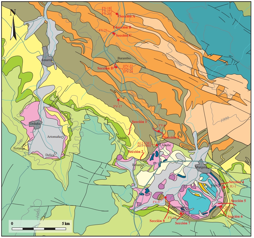
| Other Maps #1 (source) | Perona, J., 2016. Mineralizaciones de Pb-Zn asociadas a los diapiros de Murguía y Orduña (Cuenca Vasco-Cantábrica) [PhD thesis]: Barcelona, Universitat de Barcelona, 281 pp. [link] |
| Other Maps #2 (source) | Perona, J., 2016. Mineralizaciones de Pb-Zn asociadas a los diapiros de Murguía y Orduña (Cuenca Vasco-Cantábrica) [PhD thesis]: Barcelona, Universitat de Barcelona, 281 pp. [link] |
| Other related references #1 | Cámara, P., 2020. Inverted turtle salt anticlines in the eastern basque-cantabrian basin, Spain. Marine and Petroleum Geology, 104358. [link] |
| Other related references #2 | Sanz, T., Lago, M., Gil, A., Galé, C., Ramajo, J., Ubide, T., Pocoví, A., Tierz, P., Larrea, P., 2013. The Upper Triassic alkaline magmatism in the NW Iberian Chain (Spain). Journal of Iberian Geology, 39, 202-222. [link] |
| Other related references #3 | Ábalos, B., Alkorta, A., Iríbar, V., 2008. Geological and isotopic constraints on the structure of the Bilbao anticlinorium (Basque–Cantabrian basin, North Spain). Journal of Structural Geology, 30(11), 1354-1367. [link] |
| Other related references #4 | Martín-Chivelet, J., López-Gómez, J., Aguado, R., Arias, C., Arribas, J., Arribas, M. E., … , Casas-Sainz, A., 2019. The Late Jurassic–Early Cretaceous Rifting. In (Quesada C., Oliveira J., eds.): The Geology of Iberia: A Geodynamic Approach. Regional Geology Reviews. Springer, Cham. [link] |
Well and Seismic Data
| UNIQUE_ID | 15 |
| Seismic survey name #1 | 8C4-S82 |
| Across structure? #1 | Y |
| Seismic profile ID (IGME) #1 | 9804 |
| Seismic profile code #1 | 14377 |
| Seismic profile name #1 | S82-23 |
| Seismic survey year #1 | 1982 |
| Data repository #1 | SIGEOF Data Catalogue (Section available under request). ©Instituto Geológico y Minero de España (IGME). https://info.igme.es/SIGEOF/ |
| Length (km) #1 | 28.09 |
| Seismic survey name #2 | 8C4-S82 |
| Across structure? #2 | N (within 3km) |
| Seismic profile ID (IGME) #2 | 9804 |
| Seismic profile code #2 | 14377 |
| Seismic profile name #2 | S82-23 |
| Seismic survey year #2 | 1982 |
| Data repository #2 | SIGEOF Data Catalogue (Section available under request). ©Instituto Geológico y Minero de España (IGME). https://info.igme.es/SIGEOF/ |
| Length (km) #2 | 28.09 |
| Seismic survey name #3 | 8C4-ZU |
| Across structure? #3 | N (within 3km) |
| Seismic profile ID (IGME) #3 | 9842 |
| Seismic profile code #3 | 14415 |
| Seismic profile name #3 | ZU-2 |
| Seismic survey year #3 | 1972 |
| Data repository #3 | SIGEOF Data Catalogue (Section available under request). ©Instituto Geológico y Minero de España (IGME). https://info.igme.es/SIGEOF/ |
| Length (km) #3 | 14.88 |
| Seismic survey name #4 | 8C-ST-112 |
| Across structure? #4 | N (within 3km) |
| Seismic profile ID (IGME) #4 | 13219 |
| Seismic profile code #4 | 17937 |
| Seismic profile name #4 | I-5 |
| Seismic survey year #4 | 1961 |
| Data repository #4 | SIGEOF Data Catalogue (Section available under request). ©Instituto Geológico y Minero de España (IGME). https://info.igme.es/SIGEOF/ |
| Length (km) #4 | 6.12 |
| Seismic survey name #5 | 8C-ST-112 |
| Across structure? #5 | N (within 3km) |
| Seismic profile ID (IGME) #5 | 13217 |
| Seismic profile code #5 | 17935 |
| Seismic profile name #5 | I-6 |
| Seismic survey year #5 | 1961 |
| Data repository #5 | SIGEOF Data Catalogue (Section available under request). ©Instituto Geológico y Minero de España (IGME). https://info.igme.es/SIGEOF/ |
| Length (km) #5 | 10.86 |
| Seismic survey name #6 | 8C4-VA |
| Across structure? #6 | N (within 3km) |
| Seismic profile ID (IGME) #6 | 9834 |
| Seismic profile code #6 | 14407 |
| Seismic profile name #6 | VA-11 |
| Seismic survey year #6 | 1976 |
| Data repository #6 | SIGEOF Data Catalogue (Section available under request). ©Instituto Geológico y Minero de España (IGME). https://info.igme.es/SIGEOF/ |
| Length (km) #6 | 18.29 |
| Seismic survey name #7 | 8C4-CC |
| Across structure? #7 | N (within 3km) |
| Seismic profile ID (IGME) #7 | 9800 |
| Seismic profile code #7 | 14373 |
| Seismic profile name #7 | CC-3 |
| Seismic survey year #7 | 1969 |
| Data repository #7 | SIGEOF Data Catalogue (Section available under request). ©Instituto Geológico y Minero de España (IGME). https://info.igme.es/SIGEOF/ |
| Length (km) #7 | 8.03 |
| Seismic survey name #8 | 8C4-ZU |
| Across structure? #8 | N (within 3km) |
| Seismic profile ID (IGME) #8 | 9843 |
| Seismic profile code #8 | 14416 |
| Seismic profile name #8 | ZU-1 |
| Seismic survey year #8 | 1972 |
| Data repository #8 | SIGEOF Data Catalogue (Section available under request). ©Instituto Geológico y Minero de España (IGME). https://info.igme.es/SIGEOF/ |
| Length (km) #8 | 15.67 |
| Seismic survey name #9 | 8C-ST-110 |
| Across structure? #9 | N (within 3km) |
| Seismic profile ID (IGME) #9 | 13180 |
| Seismic profile code #9 | 17898 |
| Seismic profile name #9 | D-8 |
| Seismic survey year #9 | 1953 |
| Data repository #9 | SIGEOF Data Catalogue (Private access section). ©Instituto Geológico y Minero de España (IGME). https://info.igme.es/SIGEOF/ |
| Length (km) #9 | 8.14 |
| Seismic survey name #10 | 9I2-RV |
| Across structure? #10 | N (within 3km) |
| Seismic profile ID (IGME) #10 | 10950 |
| Seismic profile code #10 | 15589 |
| Seismic profile name #10 | RV-5 |
| Seismic survey year #10 | 1985 |
| Data repository #10 | SIGEOF Data Catalogue (Section available under request). ©Instituto Geológico y Minero de España (IGME). https://info.igme.es/SIGEOF/ |
| Length (km) #10 | 25.40 |
| Seismic survey name #11 | |
| Across structure? #11 | |
| Seismic profile ID (IGME) #11 | |
| Seismic profile code #11 | |
| Seismic profile name #11 | |
| Seismic survey year #11 | |
| Data repository #11 | |
| Length (km) #11 | |
| Seismic survey name #12 | |
| Across structure? #12 | |
| Seismic profile ID (IGME) #12 | |
| Seismic profile code #12 | |
| Seismic profile name #12 | |
| Seismic survey year #12 | |
| Data repository #12 | |
| Length (km) #12 | |
| Seismic survey name #13 | |
| Across structure? #13 | |
| Seismic profile ID (IGME) #13 | |
| Seismic profile code #13 | |
| Seismic profile name #13 | |
| Seismic survey year #13 | |
| Data repository #13 | |
| Length (km) #13 | |
| Seismic survey name #14 | |
| Across structure? #14 | |
| Seismic profile ID (IGME) #14 | |
| Seismic profile code #14 | |
| Seismic profile name #14 | |
| Seismic survey year #14 | |
| Data repository #14 | |
| Length (km) #14 | |
| Seismic survey name #15 | |
| Across structure? #15 | |
| Seismic profile ID (IGME) #15 | |
| Seismic profile code #15 | |
| Seismic profile name #15 | |
| Seismic survey year #15 | |
| Data repository #15 | |
| Length (km) #15 | |
| Seismic survey name #16 | |
| Across structure? #16 | |
| Seismic profile ID (IGME) #16 | |
| Seismic profile code #16 | |
| Seismic profile name #16 | |
| Seismic survey year #16 | |
| Data repository #16 | |
| Length (km) #16 | |
| Seismic survey name #17 | |
| Across structure? #17 | |
| Seismic profile ID (IGME) #17 | |
| Seismic profile code #17 | |
| Seismic profile name #17 | |
| Seismic survey year #17 | |
| Data repository #17 | |
| Length (km) #17 | |
| Seismic survey name #18 | |
| Across structure? #18 | |
| Seismic profile ID (IGME) #18 | |
| Seismic profile code #18 | |
| Seismic profile name #18 | |
| Seismic survey year #18 | |
| Data repository #18 | |
| Length (km) #18 | |
| Seismic survey name #19 | |
| Across structure? #19 | |
| Seismic profile ID (IGME) #19 | |
| Seismic profile code #19 | |
| Seismic profile name #19 | |
| Seismic survey year #19 | |
| Data repository #19 | |
| Length (km) #19 | |
| Seismic survey name #20 | |
| Across structure? #20 | |
| Seismic profile ID (IGME) #20 | |
| Seismic profile code #20 | |
| Seismic profile name #20 | |
| Seismic survey year #20 | |
| Data repository #20 | |
| Length (km) #20 | |
| Seismic survey name #21 | |
| Across structure? #21 | |
| Seismic profile ID (IGME) #21 | |
| Seismic profile code #21 | |
| Seismic profile name #21 | |
| Seismic survey year #21 | |
| Data repository #21 | |
| Length (km) #21 | |
| Borehole name #1 | ANDAGOYA (ANDAGOIA-CUARTANGO) |
| Company #1 | CONFEDERACION HIDROGRAFICA DEL EBRO |
| Traget #1 | HYDROGEOLOGY |
| Across structure? #1 | Y |
| Borehole name #2 | ALTUBE-9 (ALT-9) |
| Company #2 | EVE |
| Traget #2 | BASE METALS |
| Across structure? #2 | Y |
| Borehole name #3 | ALTUBE-6 (ALT-6) |
| Company #3 | EVE |
| Traget #3 | BASE METALS |
| Across structure? #3 | N (within 5 km) |
| Borehole name #4 | ALTUBE-7 (ALT-7) |
| Company #4 | EVE |
| Traget #4 | BASE METALS |
| Across structure? #4 | N (within 5 km) |
| Borehole name #5 | ALTUBE-2 (ALT-2) |
| Company #5 | EVE |
| Traget #5 | BASE METALS |
| Across structure? #5 | N (within 5 km) |
| Borehole name #6 | ALTUBE-5 (ALT-5) |
| Company #6 | EVE |
| Traget #6 | BASE METALS |
| Across structure? #6 | N (within 5 km) |
| Borehole name #7 | ALTUBE-3 (ALT-3) |
| Company #7 | EVE |
| Traget #7 | BASE METALS |
| Across structure? #7 | N (within 5 km) |
| Borehole name #8 | ALTUBE-4 (ALT-4) |
| Company #8 | EVE |
| Traget #8 | BASE METALS |
| Across structure? #8 | N (within 5 km) |
| Borehole name #9 | ALTUBE-8 (ALT-8) |
| Company #9 | EVE |
| Traget #9 | BASE METALS |
| Across structure? #9 | N (within 5 km) |
| Borehole name #10 | BELUNZA-1 (BEL-1) |
| Company #10 | EVE |
| Traget #10 | BASE METALS |
| Across structure? #10 | N (within 5 km) |
| Borehole name #11 | ALTUBE-1 (ALT-1) |
| Company #11 | EVE |
| Traget #11 | BASE METALS |
| Across structure? #11 | N (within 5 km) |
| Borehole name #12 | |
| Company #12 | |
| Traget #12 | |
| Across structure? #12 | |
| Borehole name #13 | |
| Company #13 | |
| Traget #13 | |
| Across structure? #13 | |
| Borehole name #14 | |
| Company #14 | |
| Traget #14 | |
| Across structure? #14 | |
| Borehole name #15 | |
| Company #15 | |
| Traget #15 | |
| Across structure? #15 |
Geographical Data (EPSG:4326 - WGS 84)
| UNIQUE_ID | 15 |
| X Centroid (Structure shape) | -2.851281 |
| Y Centroid (Structure shape) | -2.851281 |
| Xmin (Structure shape) | -2.924648 |
| Xmax (Structure shape) | -2.796276 |
| Ymin (Structure shape) | 42.916011 |
| Ymax (Structure shape) | 42.979151 |
| Xmin seismic line #1 | -2.811924 |
| Xmax seismic line #1 | -2.503276 |
| Ymin seismic line #1 | 42.831730 |
| Ymax seismic line #1 | 42.939505 |
| Xmin seismic line #2 | -2.811924 |
| Xmax seismic line #2 | -2.503276 |
| Ymin seismic line #2 | 42.831730 |
| Ymax seismic line #2 | 42.939505 |
| Xmin seismic line #3 | -2.925460 |
| Xmax seismic line #3 | -2.863138 |
| Ymin seismic line #3 | 42.778226 |
| Ymax seismic line #3 | 42.903981 |
| Xmin seismic line #4 | -2.815636 |
| Xmax seismic line #4 | -2.751711 |
| Ymin seismic line #4 | 42.868816 |
| Ymax seismic line #4 | 42.895170 |
| Xmin seismic line #5 | -2.804539 |
| Xmax seismic line #5 | -2.754633 |
| Ymin seismic line #5 | 42.841144 |
| Ymax seismic line #5 | 42.910825 |
| Xmin seismic line #6 | -2.878523 |
| Xmax seismic line #6 | -2.848432 |
| Ymin seismic line #6 | 42.998328 |
| Ymax seismic line #6 | 43.155771 |
| Xmin seismic line #7 | -2.934275 |
| Xmax seismic line #7 | -2.906185 |
| Ymin seismic line #7 | 42.834236 |
| Ymax seismic line #7 | 42.903359 |
| Xmin seismic line #8 | -2.977397 |
| Xmax seismic line #8 | -2.925971 |
| Ymin seismic line #8 | 42.794476 |
| Ymax seismic line #8 | 42.930299 |
| Xmin seismic line #9 | -2.767325 |
| Xmax seismic line #9 | -2.704146 |
| Ymin seismic line #9 | 42.894808 |
| Ymax seismic line #9 | 42.948491 |
| Xmin seismic line #10 | -1.264222 |
| Xmax seismic line #10 | -1.123790 |
| Ymin seismic line #10 | 38.262455 |
| Ymax seismic line #10 | 38.462616 |
| Xmin seismic line #11 | |
| Xmax seismic line #11 | |
| Ymin seismic line #11 | |
| Ymax seismic line #11 | |
| Xmin seismic line #12 | |
| Xmax seismic line #12 | |
| Ymin seismic line #12 | |
| Ymax seismic line #12 | |
| Xmin seismic line #13 | |
| Xmax seismic line #13 | |
| Ymin seismic line #13 | |
| Ymax seismic line #13 | |
| Xmin seismic line #14 | |
| Xmax seismic line #14 | |
| Ymin seismic line #14 | |
| Ymax seismic line #14 | |
| Xmin seismic line #15 | |
| Xmax seismic line #15 | |
| Ymin seismic line #15 | |
| Ymax seismic line #15 | |
| Xmin seismic line #16 | |
| Xmax seismic line #16 | |
| Ymin seismic line #16 | |
| Ymax seismic line #16 | |
| Xmin seismic line #17 | |
| Xmax seismic line #17 | |
| Ymin seismic line #17 | |
| Ymax seismic line #17 | |
| Xmin seismic line #18 | |
| Xmax seismic line #18 | |
| Ymin seismic line #18 | |
| Ymax seismic line #18 | |
| Xmin seismic line #19 | |
| Xmax seismic line #19 | |
| Ymin seismic line #19 | |
| Ymax seismic line #19 | |
| Xmin seismic line #20 | |
| Xmax seismic line #20 | |
| Ymin seismic line #20 | |
| Ymax seismic line #20 | |
| Xmin seismic line #21 | |
| Xmax seismic line #21 | |
| Ymin seismic line #21 | |
| Ymax seismic line #21 | |
| X borehole #1 | -2.904495 |
| Y borehole #1 | 42.924202 |
| X borehole #2 | -2.871733 |
| Y borehole #2 | 42.975292 |
| X borehole #3 | -2.865553 |
| Y borehole #3 | 42.980832 |
| X borehole #4 | -2.867221 |
| Y borehole #4 | 42.980429 |
| X borehole #5 | -2.867307 |
| Y borehole #5 | 42.980411 |
| X borehole #6 | -2.870219 |
| Y borehole #6 | 42.978289 |
| X borehole #7 | -2.864718 |
| Y borehole #7 | 42.980894 |
| X borehole #8 | -2.866272 |
| Y borehole #8 | 42.982706 |
| X borehole #9 | -2.868879 |
| Y borehole #9 | 42.979755 |
| X borehole #10 | -2.888283 |
| Y borehole #10 | 42.965242 |
| X borehole #11 | -2.870267 |
| Y borehole #11 | 42.978748 |
| X borehole #12 | |
| Y borehole #12 | |
| X borehole #13 | |
| Y borehole #13 | |
| X borehole #14 | |
| Y borehole #14 | |
| X borehole #15 | |
| Y borehole #15 |

