General Information
| Structure type | Evaporite-cored anticline |
| Deformed/Undeformed | Deformed |
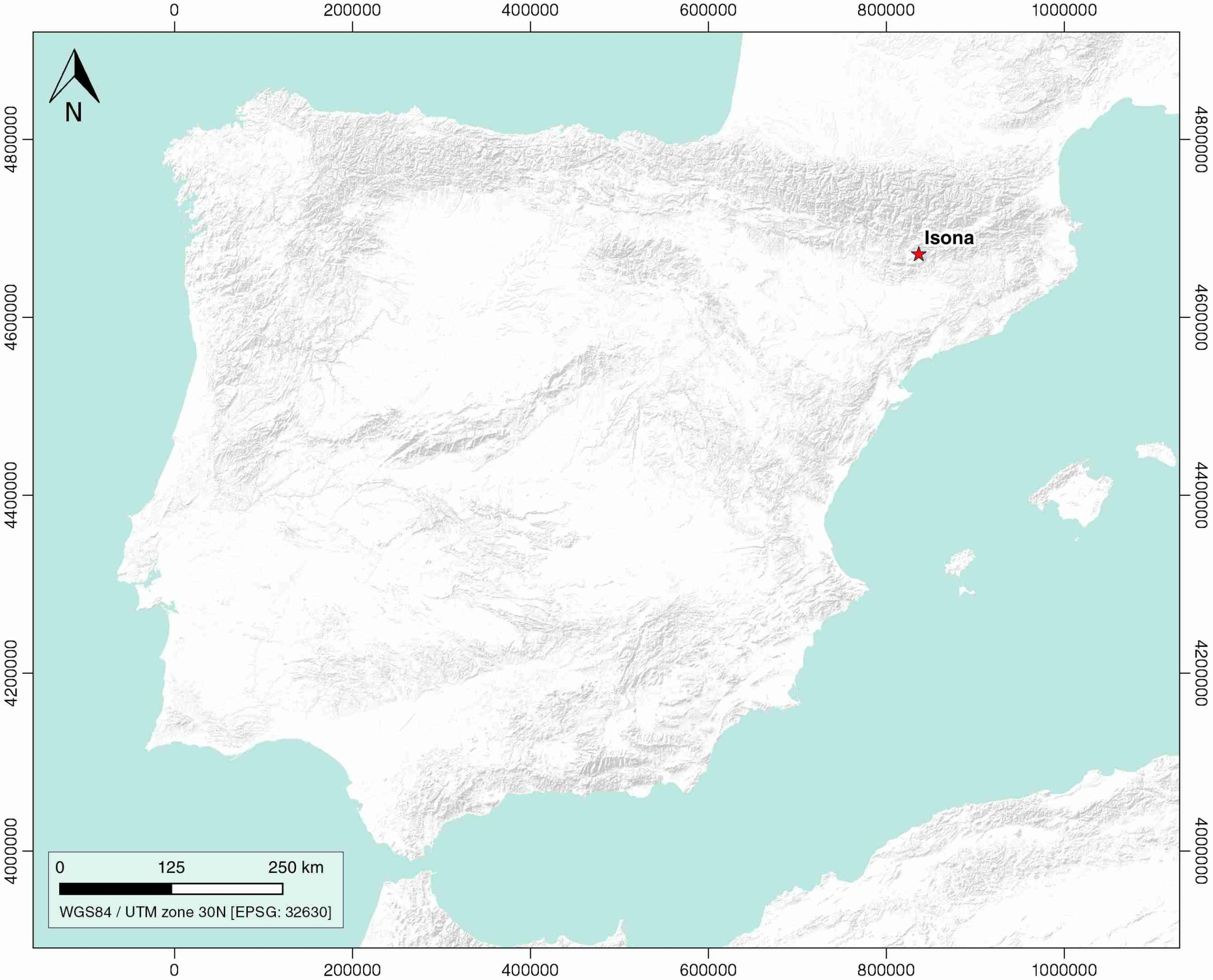
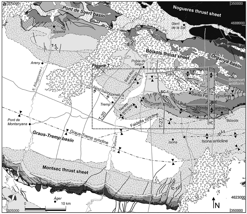
| Geological Setting | South Pyrenees Central Unit (Montsec thrust sheet), Southern Pyrenees |
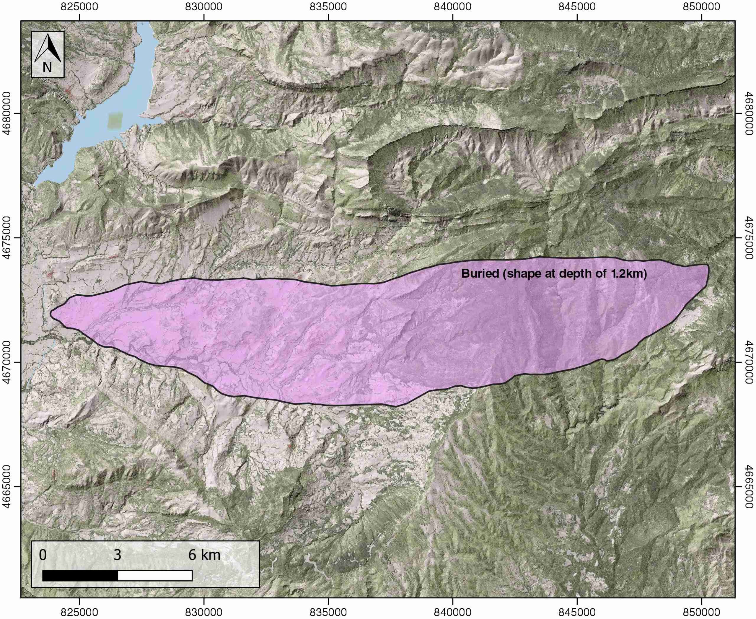
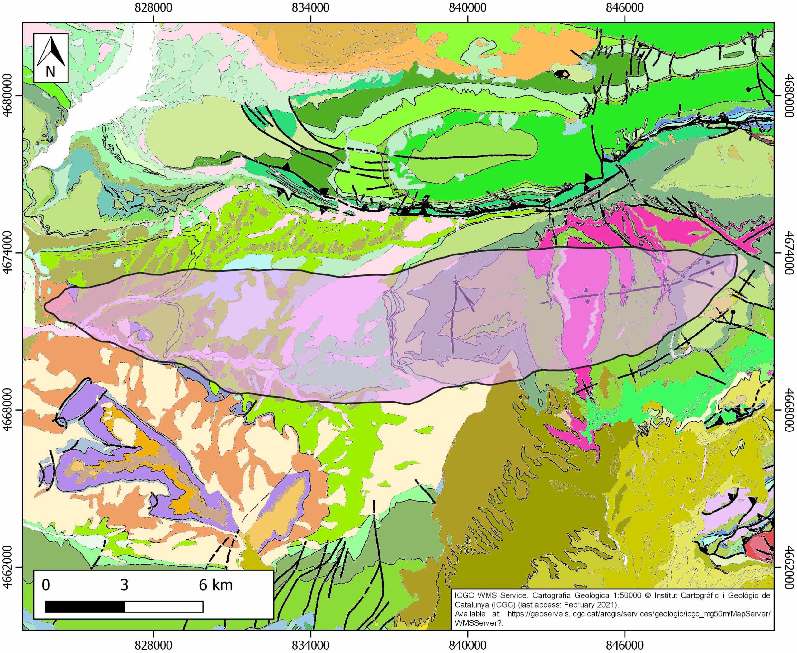
| Outcropping/buried | Buried |
| Evaporite unit/s name | Keuper facies |
| Evaporite unit/s age | Carnian-Rhaetian (Upper Triassic) |
| Evaporite unit/s origin | Marine |
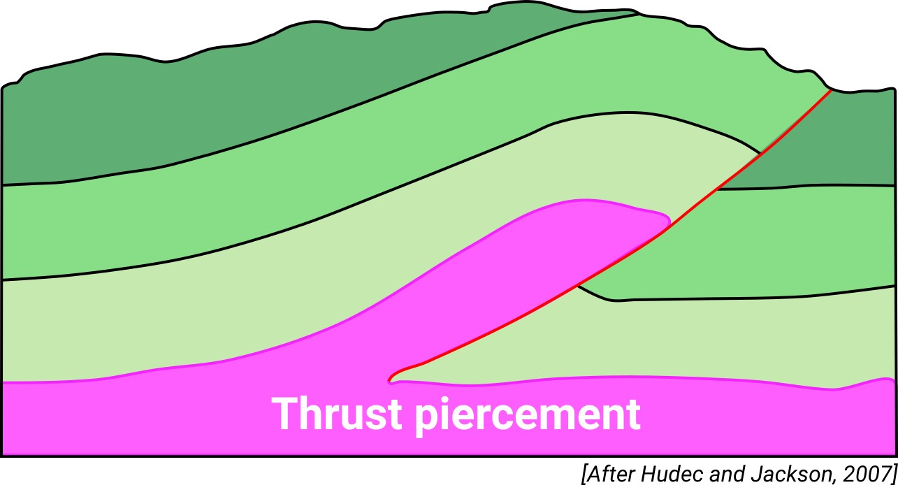
| Classif. (Hudec and Jackson, 2009) | Thrust piercement |
| Classif. (Jackson and Talbot, 1986) | Salt roller |
| Age of evaporite flow or deformation (when deformed) | late Cretaceous to Eocene |
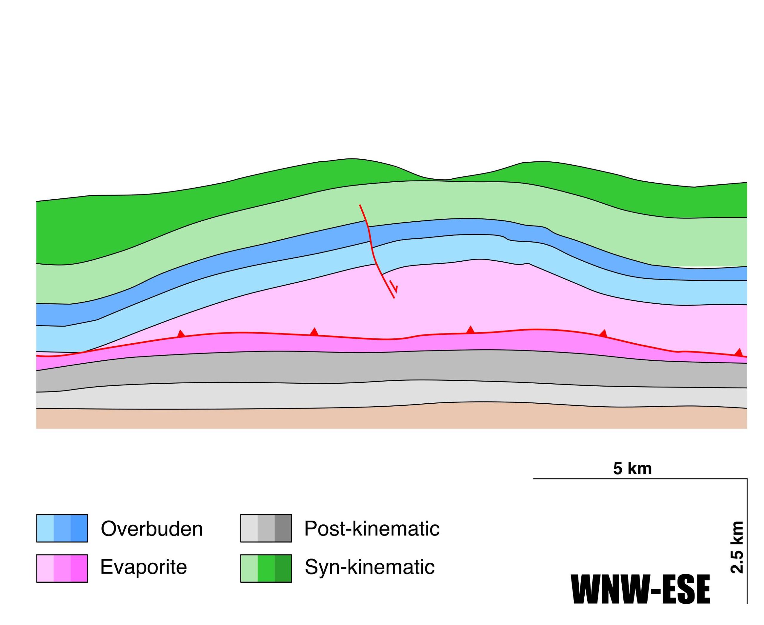
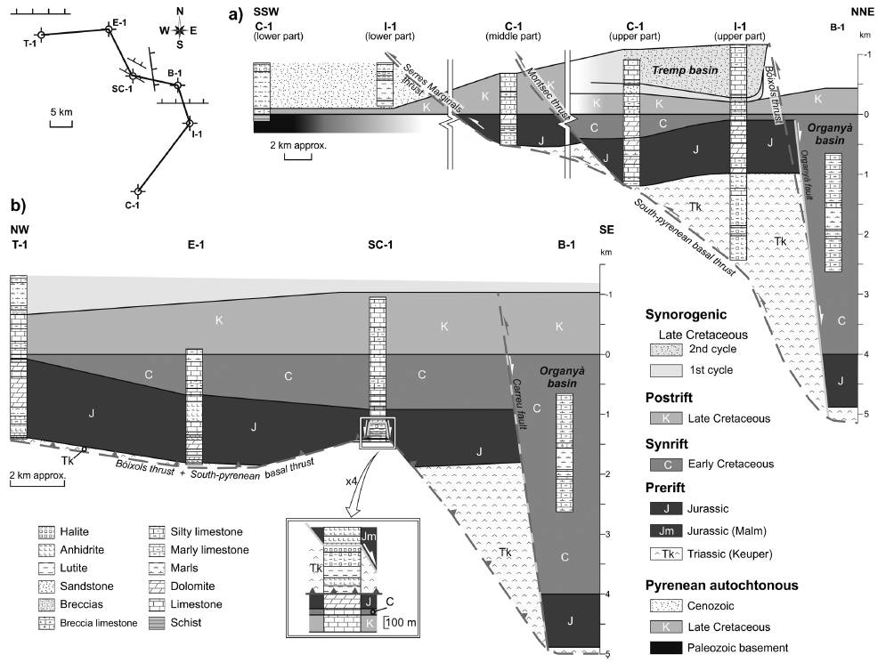
| Other comments | Detachment anticline cored by a 1.5km thick succession of Triassic rocks. Detachement level located at the top of Priabonian salt succession (see Muñoz et al., 2018). |
Generic Data
| Unique ID | 52 |
| Name | Isona |
| Structure type | Evaporite-cored anticline |
| Deformed/Undeformed | Deformed |
| Buried/Outcropping | Buried |
| Geological setting | Southern Pyrenees |
| Geological Regional Setting | South Pyrenees Central Unit (Montsec thrust sheet) |
| Evaporite unit/s name | Keuper facies |
| Evaporite unit/s age | Carnian-Rhaetian (Upper Triassic) |
| Evaporite unit/s era | Mesozoic |
| Evaporite unit/s origin | Marine |
| Evaporite unit/s composition | Mudstone-Halite-Anhydrite-Claystone |
| Post-kinematic unit/s (or post-evaporite units when evaporites are undeformed) | – |
| Post-kinematic unit/s age (or post-evaporite units when evaporites are undeformed) | – |
| Classification (Hudec and Jackson, 2009) | Thrust piercement |
| Classification (Jackson and Talbot, 1986) | Salt roller (detachment) |
| Mining activity? | N |
| Mining activity start | |
| Mining activity end | |
| Mining galleries? | |
| Mining products | |
| Mining sub-products | |
| Evaporite flow? | Y |
| Age of evaporite flow | Late Cretaceous-Early Eocene |
| Flow or deformation triggering mechanisms | Montsec thrust sheet |
| Flow-linked structures? | Y |
| Halokinetic structures | Anticline folding |
| Post-evaporite and pre-kinematic unit/s (overbuden) | Jurassic (dolostones, limestones, marly limestones) ; Lower Cretaceous (limestones) ; Cenomanian-Lower Santonian (limestones) |
| Syn-kinematic unit/s | Upper Santonian-Campanian (limestones, silty limestones) ; Campanian-Maastrichtian (Areny Group, sandstones and limestones) ; Palaeocene-Early Eocene (Garum facies, carbonates and mudstones) |
| Available seismic profiles | T-27 / TR-65 / TR-3 / T-3-1 / T-3 / T-22 / TR-51 / PIR-86-01 / PIR-86-01 / PIR-86-01 / PIR-86-01 / T-78 / TR-53 / 9 / TR-47 / TR-2 / T-2 / T-47-N / T-25 / TR-1 / TR-63 |
| Available boreholes | ISONA-1 / ISONA-FIGUEROLA / BOIXOLS-1 / TREMP / BOIXOLS (ABELLA DE LA CONCA) |
| Additional comments | Detachment anticline cored by a 1.5km thick succession of Triassic rocks. Detachement level located at the top of Priabonian salt succession (see Muñoz et al., 2018) |
Mining Data
| UNIQUE_ID | 52 |
| Minning exploitations within <2km? | N |
| Historical/Active | |
| Exploitation name #1 | |
| Exploitation ID (Spanish National Mining Cadastre) #1 | |
| Municipality #1 | |
| Province #1 | |
| Company #1 | |
| Main minning Products #1 | |
| Exploitation name #2 | |
| Exploitation ID (Spanish National Mining Cadastre) #2 | |
| Municipality #2 | |
| Province #2 | |
| Company #2 | |
| Main minning Products #2 | |
| Exploitation name #3 | |
| Exploitation ID (Spanish National Mining Cadastre) #3 | |
| Municipality #3 | |
| Province #3 | |
| Company #3 | |
| Main minning Products #3 |
Quantitative Data
| UNIQUE_ID | 52 |
| Outcropping area (km2) | Buried |
| Horizontal intersection area (km2) (when buried) | 104.13995 |
| Depth of intersection area (km2) (when buried) | 1.2 |
| Max. Width (Km) | 6.15896175 |
| Max. Length (Km) | 26.4345294 |
| Max. Evaporites thickness (km) | 1.5 |
| Max. Deformation age (Ma) | 83 |
| Min. Deformation age (Ma) | 50 |
| Deformation stages | 1 |
Reference Data
| UNIQUE_ID | 52 |
| Section source | Muñoz, J. A., Mencos, J., Roca, E., Carrera, N., Gratacós, O., Ferrer, O., Fernández, O., 2018. The structure of the South-Central-Pyrenean fold and thrust belt as constrained by subsurface data. Geologica Acta, 16(4), 439-460. [link] |
| Well / Borehole availability #1 | Mencos, J., Carrera, N., Muñoz, J. A., 2015. Influence of rift basin geometry on the subsequent postrift sedimentation and basin inversion: The Organyà Basin and the Bóixols thrust sheet (south central Pyrenees). Tectonics, 34(7), 1452-1474. [link] |
| Well / Borehole availability #2 | Muñoz, J. A., Mencos, J., Roca, E., Carrera, N., Gratacós, O., Ferrer, O., Fernández, O., 2018. The structure of the South-Central-Pyrenean fold and thrust belt as constrained by subsurface data. Geologica Acta, 16(4), 439-460. [link] |
| Available data (Stratigraphy) #1 | Muñoz, J. A., Mencos, J., Roca, E., Carrera, N., Gratacós, O., Ferrer, O., Fernández, O., 2018. The structure of the South-Central-Pyrenean fold and thrust belt as constrained by subsurface data. Geologica Acta, 16(4), 439-460. [link] |
| Available data (Stratigraphy) #2 | Chanvry, E., Deschamps, R., Joseph, P., Puigdefàbregas, C., Poyatos-Moré, M., Serra-Kiel, J., García, D., Teinturier, S., 2018. The influence of intrabasinal tectonics in the stratigraphic evolution of piggyback basin fills: Towards a model from the Tremp-Graus-Ainsa Basin (South-Pyrenean Zone, Spain). Sedimentary Geology, 377, 34-62. [link] |
| Available data (Stratigraphy) #3 | Vergés, J., Burbank, D. W., 1996. Eocene-Oligocene thrusting and basin configuration in the eastern and central Pyrenees (Spain). Tertiary basins of Spain: the stratigraphic record of crustal kinematics, 6, 120. [link] |
| Available data (Stratigraphy) #4 | Mencos, J., Carrera, N., Muñoz, J. A., 2015. Influence of rift basin geometry on the subsequent postrift sedimentation and basin inversion: The Organyà Basin and the Bóixols thrust sheet (south central Pyrenees). Tectonics, 34(7), 1452-1474. [link] |
| Available data (Stratigraphy) #5 | Vergés, J., 1998. Estudi geologic del vessant sud del Pirineu oriental i central Evolucio cinematica en 3D [Ph.D. thesis]: Universitat de Barcelona, Barcelona, 181pp. [link] |
| Available data (Stratigraphy) #6 | Guillaume, B., Dhont, D., Brusset, S., 2008. Three-dimensional geologic imaging and tectonic control on stratigraphic architecture: Upper Cretaceous of the Tremp Basin (south-central Pyrenees, Spain). AAPG bulletin, 92(2), 249-269. [link] |
| Regional Stratigraphy | Mencos, J., Carrera, N., Muñoz, J. A., 2015. Influence of rift basin geometry on the subsequent postrift sedimentation and basin inversion: The Organyà Basin and the Bóixols thrust sheet (south central Pyrenees). Tectonics, 34(7), 1452-1474. [link] |
| Seismic data availability #1 | Muñoz, J. A., Mencos, J., Roca, E., Carrera, N., Gratacós, O., Ferrer, O., Fernández, O., 2018. The structure of the South-Central-Pyrenean fold and thrust belt as constrained by subsurface data. Geologica Acta, 16(4), 439-460. [link] |
| Seismic data availability #2 | n.a. |
| Seismic data availability #3 | n.a. |
| Available data (Structure) #1 | Robert, R., Robion, P., Souloumiac, P., David, C., Saillet, E., 2018. Deformation bands, early markers of tectonic activity in front of a fold-and-thrust belt: Example from the Tremp-Graus basin, southern Pyrenees, Spain. Journal of Structural Geology, 110, 65-85. [link] |
| Available data (Structure) #2 | Muñoz, J. A., Mencos, J., Roca, E., Carrera, N., Gratacós, O., Ferrer, O., Fernández, O., 2018. The structure of the South-Central-Pyrenean fold and thrust belt as constrained by subsurface data. Geologica Acta, 16(4), 439-460. [link] |
| Available data (Structure) #3 | Guillaume, B., Dhont, D., Brusset, S., 2008. Three-dimensional geologic imaging and tectonic control on stratigraphic architecture: Upper Cretaceous of the Tremp Basin (south-central Pyrenees, Spain). AAPG bulletin, 92(2), 249-269. [link] |
| Available data (Structure) #4 | Vergés, J., 1998. Estudi geologic del vessant sud del Pirineu oriental i central Evolucio cinematica en 3D [Ph.D. thesis]: Universitat de Barcelona, Barcelona, 181pp. [link] |
| Available data (Structure) #5 | Mencos, J., Carrera, N., Muñoz, J. A., 2015. Influence of rift basin geometry on the subsequent postrift sedimentation and basin inversion: The Organyà Basin and the Bóixols thrust sheet (south central Pyrenees). Tectonics, 34(7), 1452-1474. [link] |
| Available data (Structure) #6 | Mouthereau, F., Filleaudeau, P. Y., Vacherat, A., Pik, R., Lacombe, O., Fellin, M. G., Castelltort, S., Christophoul, F., Masini, E., 2014. Placing limits to shortening evolution in the Pyrenees: Role of margin architecture and implications for the Iberia/Europe convergence. Tectonics, 33(12), 2283-2314. [link] |
| Available data (Analogue modelling) #1 | n.a. |
| Available data (Analogue modelling) #2 | n.a. |
| Available data (Analogue modelling) #3 | n.a. |
| Available data (Gravimetry – Tomography) #1 | Ayala, C., Bohoyo, F., Maestro, A., Reguera, M. I., Torne, M., Rubio, F., Fernández, M., García-Lobón, J. L., 2016. Updated Bouguer anomalies of the Iberian Peninsula: a new perspective to interpret the regional geology. Journal of Maps, 12(5), 1089-1092. [link] |
| Available data (Gravimetry – Tomography) #2 | ICGC, 2012. Mapa Gravimètric de Catalunya 1:500.000. Barcelona, Servei Geològic de Catalunya. [link] |
| Available data (Gravimetry – Tomography) #3 | Pedrera, A., García‐Senz, J., Ayala, C., Ruiz‐Constán, A., Rodríguez‐Fernández, L. R., Robador, A., González Menéndez, L., 2017. Reconstruction of the exhumed mantle across the North Iberian Margin by crustal‐scale 3‐D gravity inversion and geological cross section. Tectonics, 36, 3155-3177. [link] |
| Available data (Geochemistry) #1 | Ortí, F., García-Veigas, J., Rossell, L., Jurado, M. J., Utrilla, R., 1996. Formaciones salinas de las cuencas triásicas en la Península Ibérica: Caracterización Petrológica y Geoquímica. Cuadernos de Geología Ibérica, 20, 13-35. [link] |
| Available data (Geochemistry) #2 | n.a. |
| Available data (Geochemistry) #3 | n.a. |
| Available data (Geochemistry) #4 | n.a. |
| Available data (Petrophysics) #1 | n.a. |
| Available data (Petrophysics) #2 | n.a. |
| IGME Geological Map (MAGNA50) Sheet number | 290-Isona. [link] |
| Other Maps #1 (source) | Mencos, J., Carrera, N., Muñoz, J. A., 2015. Influence of rift basin geometry on the subsequent postrift sedimentation and basin inversion: The Organyà Basin and the Bóixols thrust sheet (south central Pyrenees). Tectonics, 34(7), 1452-1474. [link] |
| Other Maps #2 (source) | Mencos, J., Carrera, N., Muñoz, J. A., 2015. Influence of rift basin geometry on the subsequent postrift sedimentation and basin inversion: The Organyà Basin and the Bóixols thrust sheet (south central Pyrenees). Tectonics, 34(7), 1452-1474. [link] |
| Other related references #1 | Caus, E., Gómez-Garrido, A., Simó, A., Sofiano, K., 1993. Cenomanian-Turonian platform to basin integrated stratigraphy in the South Pyrenees (Spain). Cretaceous Research, 14(4-5), 531-551. [link] |
| Other related references #2 | Lanaja, J. M., R. Querol, A. Navarro, 1987. Contribución de la Exploración Petrolífera al Conocimiento de la Geología de España, pp. 1–465, Instituto Geológico y Minero de España, Madrid. [link] |
| Other related references #3 | Rosell, J., 1967. Estudio geológico del sector del Prepirineo comprendido entre los ríos Segre y Noguera Ribagorzana (Prov. de Lérida). Pirineos, 21, 214, Consejo Superior de Investigaciones Científicas, Madrid. [link] |
| Other related references #4 | n.a. |
Well and Seismic Data
| UNIQUE_ID | 52 |
| Seismic survey name #1 | 12D4-T |
| Across structure? #1 | Y |
| Seismic profile ID (IGME) #1 | 10539 |
| Seismic profile code #1 | 15168 |
| Seismic profile name #1 | T-27 |
| Seismic survey year #1 | 1968 |
| Data repository #1 | SIGEOF Data Catalogue (Section available under request). ©Instituto Geológico y Minero de España (IGME). https://info.igme.es/SIGEOF/ |
| Length (km) #1 | 15.30 |
| Seismic survey name #2 | 12D4-TR |
| Across structure? #2 | Y |
| Seismic profile ID (IGME) #2 | 10547 |
| Seismic profile code #2 | 15176 |
| Seismic profile name #2 | TR-65 |
| Seismic survey year #2 | 1978 |
| Data repository #2 | SIGEOF Data Catalogue (Section available under request). ©Instituto Geológico y Minero de España (IGME). https://info.igme.es/SIGEOF/ |
| Length (km) #2 | 14.43 |
| Seismic survey name #3 | 12D4-TR |
| Across structure? #3 | Y |
| Seismic profile ID (IGME) #3 | 10552 |
| Seismic profile code #3 | 15181 |
| Seismic profile name #3 | TR-3 |
| Seismic survey year #3 | 1978 |
| Data repository #3 | SIGEOF Data Catalogue (Private access section). ©Instituto Geológico y Minero de España (IGME). https://info.igme.es/SIGEOF/ |
| Length (km) #3 | 16.21 |
| Seismic survey name #4 | 12D4-T |
| Across structure? #4 | Y |
| Seismic profile ID (IGME) #4 | 10534 |
| Seismic profile code #4 | 15163 |
| Seismic profile name #4 | T-3-1 |
| Seismic survey year #4 | 1968 |
| Data repository #4 | SIGEOF Data Catalogue (Private access section). ©Instituto Geológico y Minero de España (IGME). https://info.igme.es/SIGEOF/ |
| Length (km) #4 | 4.99 |
| Seismic survey name #5 | 12D4-T |
| Across structure? #5 | Y |
| Seismic profile ID (IGME) #5 | 10536 |
| Seismic profile code #5 | 15165 |
| Seismic profile name #5 | T-3 |
| Seismic survey year #5 | 1968 |
| Data repository #5 | SIGEOF Data Catalogue (Section available under request). ©Instituto Geológico y Minero de España (IGME). https://info.igme.es/SIGEOF/ |
| Length (km) #5 | 20.95 |
| Seismic survey name #6 | 11D1-T |
| Across structure? #6 | Y |
| Seismic profile ID (IGME) #6 | 10278 |
| Seismic profile code #6 | 14906 |
| Seismic profile name #6 | T-22 |
| Seismic survey year #6 | 1968 |
| Data repository #6 | SIGEOF Data Catalogue (Section available under request). ©Instituto Geológico y Minero de España (IGME). https://info.igme.es/SIGEOF/ |
| Length (km) #6 | 7.21 |
| Seismic survey name #7 | 12D4-TR |
| Across structure? #7 | Y |
| Seismic profile ID (IGME) #7 | 10550 |
| Seismic profile code #7 | 15179 |
| Seismic profile name #7 | TR-51 |
| Seismic survey year #7 | 1978 |
| Data repository #7 | SIGEOF Data Catalogue (Private access section). ©Instituto Geológico y Minero de España (IGME). https://info.igme.es/SIGEOF/ |
| Length (km) #7 | 7.48 |
| Seismic survey name #8 | 0519A86U |
| Across structure? #8 | Y |
| Seismic profile ID (IGME) #8 | 5464 |
| Seismic profile code #8 | 7888 |
| Seismic profile name #8 | PIR-86-01 |
| Seismic survey year #8 | 1986 |
| Data repository #8 | SIGEOF Data Catalogue (Section available under request). ©Instituto Geológico y Minero de España (IGME). https://info.igme.es/SIGEOF/ |
| Length (km) #8 | 15.80 |
| Seismic survey name #9 | 0519A86U |
| Across structure? #9 | Y |
| Seismic profile ID (IGME) #9 | 5463 |
| Seismic profile code #9 | 7887 |
| Seismic profile name #9 | PIR-86-01 |
| Seismic survey year #9 | 1986 |
| Data repository #9 | SIGEOF Data Catalogue (Section available under request). ©Instituto Geológico y Minero de España (IGME). https://info.igme.es/SIGEOF/ |
| Length (km) #9 | 15.83 |
| Seismic survey name #10 | 0519A86G |
| Across structure? #10 | Y |
| Seismic profile ID (IGME) #10 | 5453 |
| Seismic profile code #10 | 7877 |
| Seismic profile name #10 | PIR-86-01 |
| Seismic survey year #10 | 1986 |
| Data repository #10 | SIGEOF Data Catalogue (Section available under request). ©Instituto Geológico y Minero de España (IGME). https://info.igme.es/SIGEOF/ |
| Length (km) #10 | 30.24 |
| Seismic survey name #11 | 0519A86S |
| Across structure? #11 | Y |
| Seismic profile ID (IGME) #11 | 5458 |
| Seismic profile code #11 | 7882 |
| Seismic profile name #11 | PIR-86-01 |
| Seismic survey year #11 | 1986 |
| Data repository #11 | SIGEOF Data Catalogue (Section available under request). ©Instituto Geológico y Minero de España (IGME). https://info.igme.es/SIGEOF/ |
| Length (km) #11 | 75.97 |
| Seismic survey name #12 | 12D4-T |
| Across structure? #12 | Y |
| Seismic profile ID (IGME) #12 | 10514 |
| Seismic profile code #12 | 15143 |
| Seismic profile name #12 | T-78 |
| Seismic survey year #12 | 1968 |
| Data repository #12 | SIGEOF Data Catalogue (Private access section). ©Instituto Geológico y Minero de España (IGME). https://info.igme.es/SIGEOF/ |
| Length (km) #12 | 24.71 |
| Seismic survey name #13 | 12D4-TR |
| Across structure? #13 | Y |
| Seismic profile ID (IGME) #13 | 10549 |
| Seismic profile code #13 | 15178 |
| Seismic profile name #13 | TR-53 |
| Seismic survey year #13 | 1978 |
| Data repository #13 | SIGEOF Data Catalogue (Private access section). ©Instituto Geológico y Minero de España (IGME). https://info.igme.es/SIGEOF/ |
| Length (km) #13 | 16.77 |
| Seismic survey name #14 | 12D3-9 |
| Across structure? #14 | Y |
| Seismic profile ID (IGME) #14 | 10488 |
| Seismic profile code #14 | 15117 |
| Seismic profile name #14 | 9 |
| Seismic survey year #14 | 1961 |
| Data repository #14 | SIGEOF Data Catalogue (Private access section). ©Instituto Geológico y Minero de España (IGME). https://info.igme.es/SIGEOF/ |
| Length (km) #14 | 24.35 |
| Seismic survey name #15 | 12D3-TR |
| Across structure? #15 | Y |
| Seismic profile ID (IGME) #15 | 10509 |
| Seismic profile code #15 | 15138 |
| Seismic profile name #15 | TR-47 |
| Seismic survey year #15 | 1978 |
| Data repository #15 | SIGEOF Data Catalogue (Private access section). ©Instituto Geológico y Minero de España (IGME). https://info.igme.es/SIGEOF/ |
| Length (km) #15 | 14.84 |
| Seismic survey name #16 | 12D3-TR |
| Across structure? #16 | Y |
| Seismic profile ID (IGME) #16 | 10510 |
| Seismic profile code #16 | 15139 |
| Seismic profile name #16 | TR-2 |
| Seismic survey year #16 | 1978 |
| Data repository #16 | SIGEOF Data Catalogue (Private access section). ©Instituto Geológico y Minero de España (IGME). https://info.igme.es/SIGEOF/ |
| Length (km) #16 | 12.37 |
| Seismic survey name #17 | 12D3-T |
| Across structure? #17 | Y |
| Seismic profile ID (IGME) #17 | 10495 |
| Seismic profile code #17 | 15124 |
| Seismic profile name #17 | T-2 |
| Seismic survey year #17 | 1968 |
| Data repository #17 | SIGEOF Data Catalogue (Section available under request). ©Instituto Geológico y Minero de España (IGME). https://info.igme.es/SIGEOF/ |
| Length (km) #17 | 20.84 |
| Seismic survey name #18 | 12D4-T |
| Across structure? #18 | Y |
| Seismic profile ID (IGME) #18 | 10519 |
| Seismic profile code #18 | 15148 |
| Seismic profile name #18 | T-47-N |
| Seismic survey year #18 | 1968 |
| Data repository #18 | SIGEOF Data Catalogue (Section available under request). ©Instituto Geológico y Minero de España (IGME). https://info.igme.es/SIGEOF/ |
| Length (km) #18 | 5.46 |
| Seismic survey name #19 | 12D4-T |
| Across structure? #19 | Y |
| Seismic profile ID (IGME) #19 | 10541 |
| Seismic profile code #19 | 15170 |
| Seismic profile name #19 | T-25 |
| Seismic survey year #19 | 1968 |
| Data repository #19 | SIGEOF Data Catalogue (Section available under request). ©Instituto Geológico y Minero de España (IGME). https://info.igme.es/SIGEOF/ |
| Length (km) #19 | 14.40 |
| Seismic survey name #20 | 12D3-T |
| Across structure? #20 | Y |
| Seismic profile ID (IGME) #20 | 10493 |
| Seismic profile code #20 | 15122 |
| Seismic profile name #20 | TR-1 |
| Seismic survey year #20 | 1978 |
| Data repository #20 | SIGEOF Data Catalogue (Section available under request). ©Instituto Geológico y Minero de España (IGME). https://info.igme.es/SIGEOF/ |
| Length (km) #20 | 26.78 |
| Seismic survey name #21 | 12D3-TR |
| Across structure? #21 | N (within 3km) |
| Seismic profile ID (IGME) #21 | 10501 |
| Seismic profile code #21 | 15130 |
| Seismic profile name #21 | TR-63 |
| Seismic survey year #21 | 1978 |
| Data repository #21 | SIGEOF Data Catalogue (Section available under request). ©Instituto Geológico y Minero de España (IGME). https://info.igme.es/SIGEOF/ |
| Length (km) #21 | 8.91 |
| Borehole name #1 | ISONA-1 |
| Company #1 | ADARO |
| Traget #1 | HYDROCARBONS |
| Across structure? #1 | Y |
| Borehole name #2 | ISONA-FIGUEROLA |
| Company #2 | CONFEDERACION HIDROGRAFICA DEL EBRO |
| Traget #2 | HYDROGEOLOGY |
| Across structure? #2 | Y |
| Borehole name #3 | BOIXOLS-1 |
| Company #3 | SHELL |
| Traget #3 | HYDROCARBONS |
| Across structure? #3 | N (within 5 km) |
| Borehole name #4 | TREMP |
| Company #4 | CONFEDERACION HIDROGRAFICA DEL EBRO |
| Traget #4 | HYDROGEOLOGY |
| Across structure? #4 | N (within 5 km) |
| Borehole name #5 | BOIXOLS (ABELLA DE LA CONCA) |
| Company #5 | CONFEDERACION HIDROGRAFICA DEL EBRO |
| Traget #5 | HYDROGEOLOGY |
| Across structure? #5 | N (within 5 km) |
| Borehole name #6 | |
| Company #6 | |
| Traget #6 | |
| Across structure? #6 | |
| Borehole name #7 | |
| Company #7 | |
| Traget #7 | |
| Across structure? #7 | |
| Borehole name #8 | |
| Company #8 | |
| Traget #8 | |
| Across structure? #8 | |
| Borehole name #9 | |
| Company #9 | |
| Traget #9 | |
| Across structure? #9 | |
| Borehole name #10 | |
| Company #10 | |
| Traget #10 | |
| Across structure? #10 | |
| Borehole name #11 | |
| Company #11 | |
| Traget #11 | |
| Across structure? #11 | |
| Borehole name #12 | |
| Company #12 | |
| Traget #12 | |
| Across structure? #12 | |
| Borehole name #13 | |
| Company #13 | |
| Traget #13 | |
| Across structure? #13 | |
| Borehole name #14 | |
| Company #14 | |
| Traget #14 | |
| Across structure? #14 | |
| Borehole name #15 | |
| Company #15 | |
| Traget #15 | |
| Across structure? #15 |
Geographical Data (EPSG:4326 - WGS 84)
| UNIQUE_ID | 52 |
| X Centroid (Structure shape) | 1.082715 |
| Y Centroid (Structure shape) | 1.082715 |
| Xmin (Structure shape) | 0.917956 |
| Xmax (Structure shape) | 1.238461 |
| Ymin (Structure shape) | 42.093294 |
| Ymax (Structure shape) | 42.144908 |
| Xmin seismic line #1 | 1.000487 |
| Xmax seismic line #1 | 1.022339 |
| Ymin seismic line #1 | 42.128106 |
| Ymax seismic line #1 | 42.262595 |
| Xmin seismic line #2 | 1.231232 |
| Xmax seismic line #2 | 1.247745 |
| Ymin seismic line #2 | 42.015259 |
| Ymax seismic line #2 | 42.144430 |
| Xmin seismic line #3 | 1.067965 |
| Xmax seismic line #3 | 1.260789 |
| Ymin seismic line #3 | 42.128802 |
| Ymax seismic line #3 | 42.140247 |
| Xmin seismic line #4 | 1.097840 |
| Xmax seismic line #4 | 1.155995 |
| Ymin seismic line #4 | 42.127342 |
| Ymax seismic line #4 | 42.131221 |
| Xmin seismic line #5 | 0.912490 |
| Xmax seismic line #5 | 1.075815 |
| Ymin seismic line #5 | 42.127831 |
| Ymax seismic line #5 | 42.140410 |
| Xmin seismic line #6 | 0.927843 |
| Xmax seismic line #6 | 0.938501 |
| Ymin seismic line #6 | 42.127720 |
| Ymax seismic line #6 | 42.191249 |
| Xmin seismic line #7 | 1.072003 |
| Xmax seismic line #7 | 1.154271 |
| Ymin seismic line #7 | 42.077331 |
| Ymax seismic line #7 | 42.097177 |
| Xmin seismic line #8 | 0.977057 |
| Xmax seismic line #8 | 0.996864 |
| Ymin seismic line #8 | 41.992665 |
| Ymax seismic line #8 | 42.125448 |
| Xmin seismic line #9 | 0.963474 |
| Xmax seismic line #9 | 0.981639 |
| Ymin seismic line #9 | 42.125448 |
| Ymax seismic line #9 | 42.257895 |
| Xmin seismic line #10 | 0.956724 |
| Xmax seismic line #10 | 1.002499 |
| Ymin seismic line #10 | 42.065723 |
| Ymax seismic line #10 | 42.323121 |
| Xmin seismic line #11 | 0.956724 |
| Xmax seismic line #11 | 1.001253 |
| Ymin seismic line #11 | 41.526764 |
| Ymax seismic line #11 | 42.183448 |
| Xmin seismic line #12 | 0.961421 |
| Xmax seismic line #12 | 0.999681 |
| Ymin seismic line #12 | 42.042440 |
| Ymax seismic line #12 | 42.248518 |
| Xmin seismic line #13 | 1.162210 |
| Xmax seismic line #13 | 1.209488 |
| Ymin seismic line #13 | 42.042395 |
| Ymax seismic line #13 | 42.171205 |
| Xmin seismic line #14 | 1.050482 |
| Xmax seismic line #14 | 1.202087 |
| Ymin seismic line #14 | 41.956922 |
| Ymax seismic line #14 | 42.100570 |
| Xmin seismic line #15 | 1.140507 |
| Xmax seismic line #15 | 1.178805 |
| Ymin seismic line #15 | 42.033354 |
| Ymax seismic line #15 | 42.159089 |
| Xmin seismic line #16 | 1.076381 |
| Xmax seismic line #16 | 1.093113 |
| Ymin seismic line #16 | 42.038486 |
| Ymax seismic line #16 | 42.146684 |
| Xmin seismic line #17 | 1.031706 |
| Xmax seismic line #17 | 1.105474 |
| Ymin seismic line #17 | 42.036807 |
| Ymax seismic line #17 | 42.206956 |
| Xmin seismic line #18 | 1.146833 |
| Xmax seismic line #18 | 1.152636 |
| Ymin seismic line #18 | 42.086529 |
| Ymax seismic line #18 | 42.135407 |
| Xmin seismic line #19 | 0.962781 |
| Xmax seismic line #19 | 0.978820 |
| Ymin seismic line #19 | 42.130810 |
| Ymax seismic line #19 | 42.258677 |
| Xmin seismic line #20 | 0.974969 |
| Xmax seismic line #20 | 0.999047 |
| Ymin seismic line #20 | 41.907441 |
| Ymax seismic line #20 | 42.143721 |
| Xmin seismic line #21 | 1.200548 |
| Xmax seismic line #21 | 1.221103 |
| Ymin seismic line #21 | 42.016262 |
| Ymax seismic line #21 | 42.094885 |
| X borehole #1 | 1.194264 |
| Y borehole #1 | 42.133014 |
| X borehole #2 | 0.983386 |
| Y borehole #2 | 42.129826 |
| X borehole #3 | 1.134820 |
| Y borehole #3 | 42.186075 |
| X borehole #4 | 0.911305 |
| Y borehole #4 | 42.160079 |
| X borehole #5 | 1.162385 |
| Y borehole #5 | 42.179584 |
| X borehole #6 | |
| Y borehole #6 | |
| X borehole #7 | |
| Y borehole #7 | |
| X borehole #8 | |
| Y borehole #8 | |
| X borehole #9 | |
| Y borehole #9 | |
| X borehole #10 | |
| Y borehole #10 | |
| X borehole #11 | |
| Y borehole #11 | |
| X borehole #12 | |
| Y borehole #12 | |
| X borehole #13 | |
| Y borehole #13 | |
| X borehole #14 | |
| Y borehole #14 | |
| X borehole #15 | |
| Y borehole #15 |

