Estopiñan-Canelles
ID #071
General Information
| Structure type | Evaporite body |
| Deformed/Undeformed | Deformed |
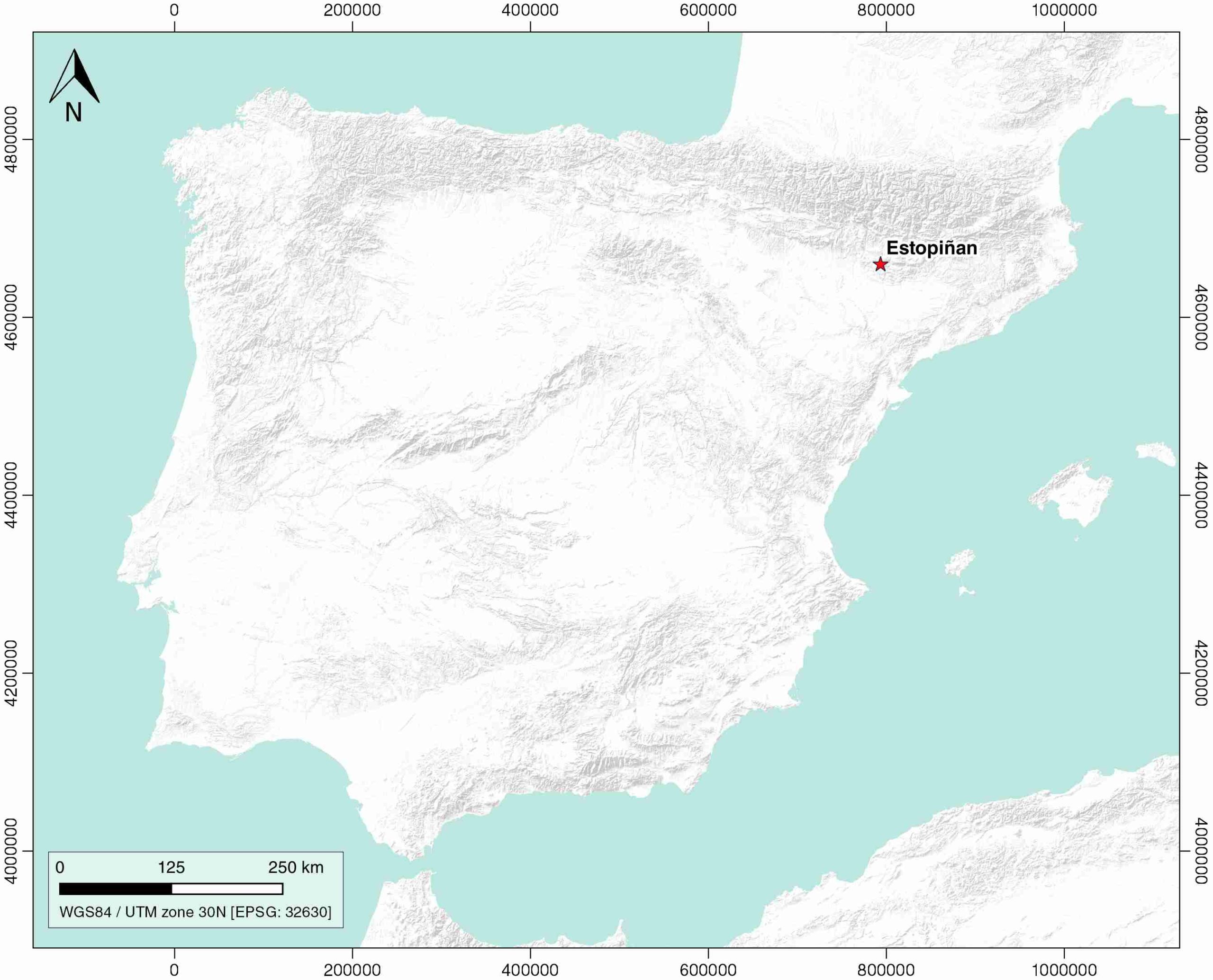
| Geological Setting | South Pyrenees Central Unit (Sierras Marginales; Boltaña-Balzes thrust sheet), Southern Pyrenees |
| Outcropping/buried | Outcropping |
| Evaporite unit/s name | El Pont de Suert Fm. |
| Evaporite unit/s age | Upper Anisian and Carnian-Rhaetian (Middle-Upper Triassic) |
| Evaporite unit/s origin | Marine |
| Classif. (Hudec and Jackson, 2009) | No diapirism |
| Classif. (Jackson and Talbot, 1986) | No diapirism |
| Age of evaporite flow or deformation (when deformed) | Eocene, Oligocene to Miocene |
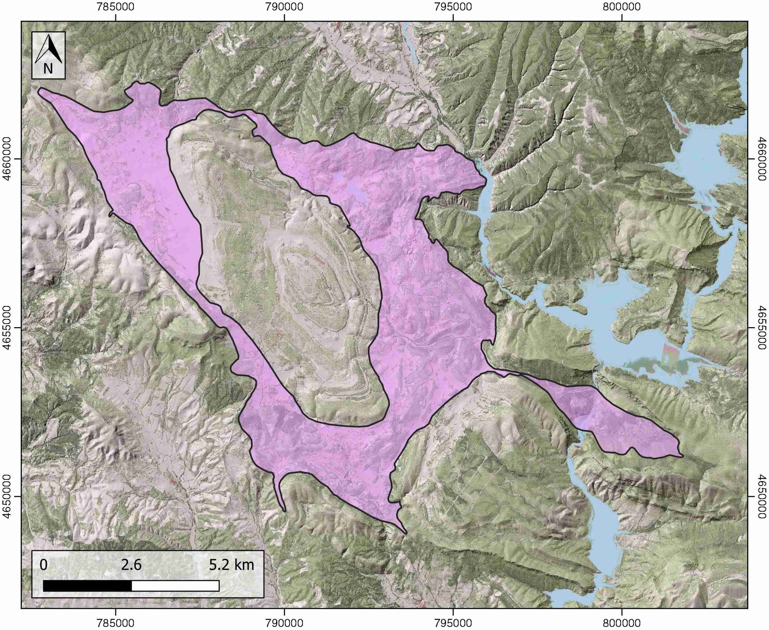
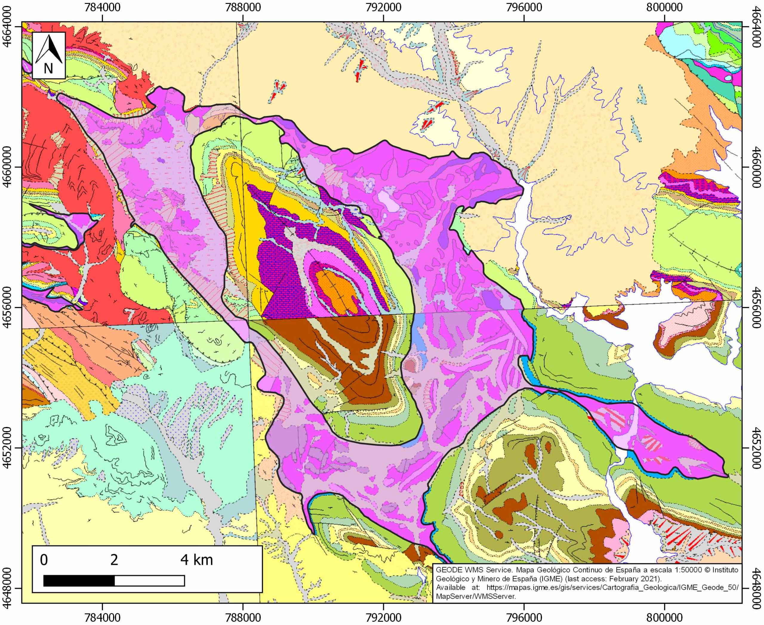
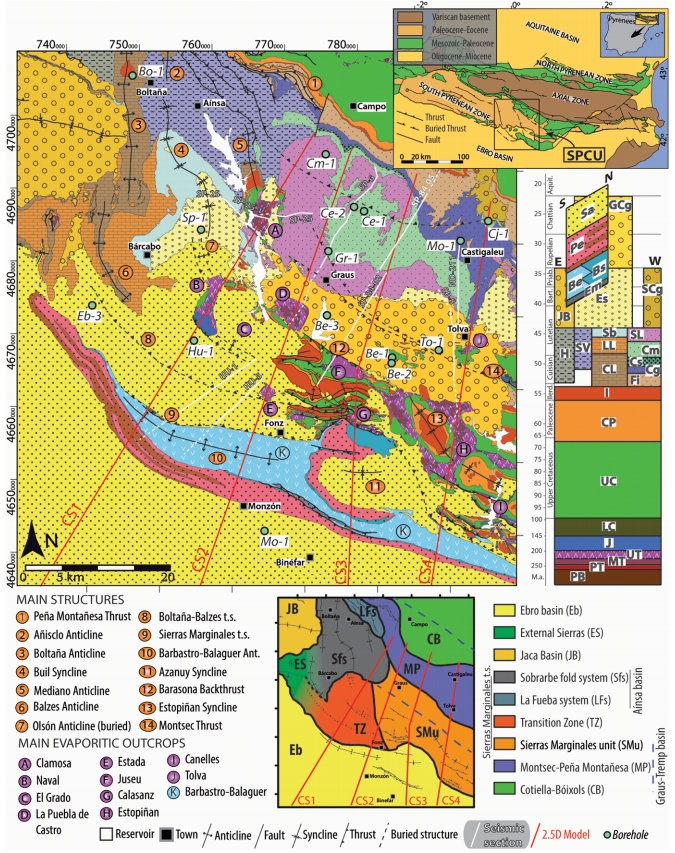
| Other comments | Evaporites outcrop in both flanks of the NW-SE trending Estopiñan syncline and in the core of the E-W trending Canelles anticline. |
Generic Data
| Unique ID | 71 |
| Name | Estopiñan-Canelles |
| Structure type | Evaporite body |
| Deformed/Undeformed | Deformed |
| Buried/Outcropping | Outcropping |
| Geological setting | Southern Pyrenees |
| Geological Regional Setting | South Pyrenees Central Unit (Sierras Marginales; Boltaña-Balzes thrust sheet) |
| Evaporite unit/s name | El Pont de Suert Fm. (Middle Muschelkalk and Keuper Facies) |
| Evaporite unit/s age | Upper Anisian and Carnian-Rhaetian (Middle-Upper Triassic) |
| Evaporite unit/s era | Mesozoic |
| Evaporite unit/s origin | Marine |
| Evaporite unit/s composition | Shale-Gypsum-Anhydrite-Ophites |
| Post-kinematic unit/s (or post-evaporite units when evaporites are undeformed) | Quaternary (alluvial and colluvial detrital deposits) |
| Post-kinematic unit/s age (or post-evaporite units when evaporites are undeformed) | Pleistocene-Holocene |
| Classification (Hudec and Jackson, 2009) | No diapirism |
| Classification (Jackson and Talbot, 1986) | No diapirism |
| Mining activity? | Y |
| Mining activity start | – |
| Mining activity end | – |
| Mining galleries? | – |
| Mining products | Ophites |
| Mining sub-products | – |
| Evaporite flow? | Y |
| Age of evaporite flow | Lutetian-Priabonian (early stage) ; Late Oligocene-Early Miocene (late stage) |
| Flow or deformation triggering mechanisms | Translation–rotation of the western end of the Sierras Marginales thrust sheet (early stage) and compression (late stage) |
| Flow-linked structures? | Y |
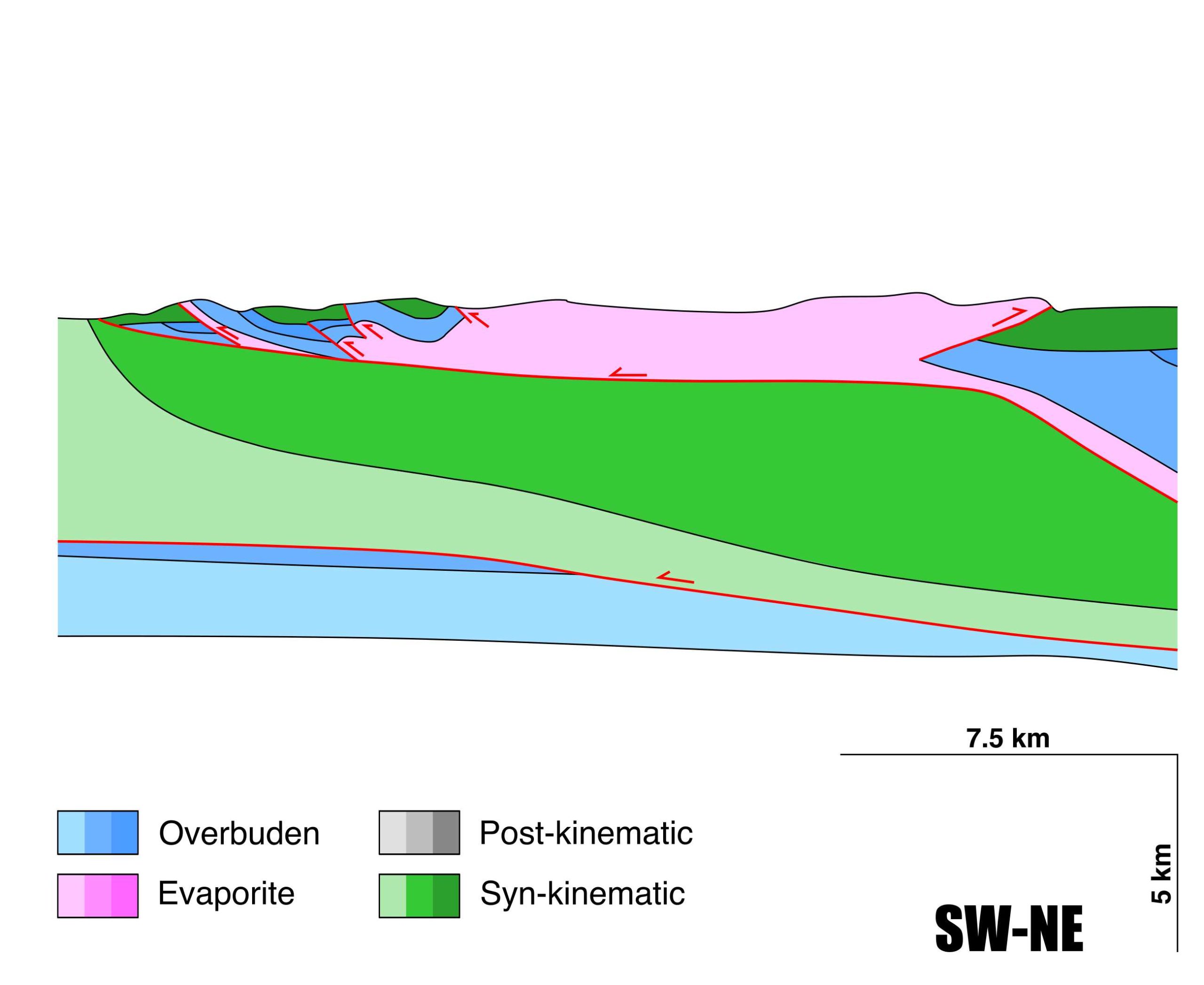
| Halokinetic structures | Normal high-angle faults / thrust faults / thickness variations / Progressive Unconformities |
| Post-evaporite and pre-kinematic unit/s (overbuden) | Lower Jurassic (limestones, dolostones and shales) ; Upper Santonian-Maastrichtian (calcarenites and limestones) ; Maastrichian-Paleocene (Garumn Facies, carbonates and shales) ; Palaeocene-Lower Eocene (shallow marines carbonates) ; Upper Eocene-Oligocene (evaporites and detrital deposits) |
| Syn-kinematic unit/s | Lutetian-Early Priabonian (marlstones, mudstones, limestones, sandstones) ; Late Oligocene-Early Miocene (alluvial fan conglomerates) |
| Available seismic profiles | ND-63 / ND-64 / SP-42 / SP-8 / SP-42 / ND-80 / SP-8 / SP-40 / ND-64 / TR-56 / SP-42 / TR-58 / SP-40 / SP-40 / SP-42 / SP-42 / HL-25 / ND-161 / ND-80 / ND-63 / ND-90 |
| Available boreholes | ESTOPIÑAN |
| Additional comments | Evaporites outcrop in both flanks of the NW-SE trending Estopiñan syncline and in the core of the E-W trending Canelles anticline |
Mining Data
| UNIQUE_ID | 71 |
| Minning exploitations within <2km? | Y |
| Historical/Active | Active |
| Exploitation name #1 | SORIANA |
| Exploitation ID (Spanish National Mining Cadastre) #1 | 132 |
| Municipality #1 | Estopiñán del Castillo |
| Province #1 | HUESCA |
| Company #1 | BENITO ARNÓ E HIJOS, SAU (BAEHSAU) |
| Main minning Products #1 | Ophites |
| Exploitation name #2 | |
| Exploitation ID (Spanish National Mining Cadastre) #2 | |
| Municipality #2 | |
| Province #2 | |
| Company #2 | |
| Main minning Products #2 | |
| Exploitation name #3 | |
| Exploitation ID (Spanish National Mining Cadastre) #3 | |
| Municipality #3 | |
| Province #3 | |
| Company #3 | |
| Main minning Products #3 |
Quantitative Data
| UNIQUE_ID | 71 |
| Outcropping area (km2) | 58.24826 |
| Horizontal intersection area (km2) (when buried) | Not buried |
| Depth of intersection area (km2) (when buried) | Not buried |
| Max. Width (Km) | 20.4337888 |
| Max. Length (Km) | 11.8452658 |
| Max. Evaporites thickness (km) | 0.6 |
| Max. Deformation age (Ma) | 47 |
| Min. Deformation age (Ma) | 20 |
| Deformation stages | 2 |
Reference Data
| UNIQUE_ID | 71 |
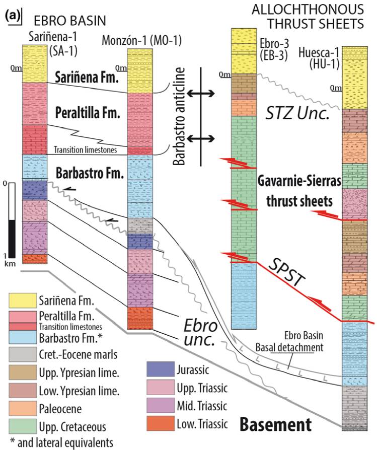
| Section source | Santolaria, P., Casas-Sainz, A. M., Soto, R., Casas, A., 2017. Gravity modelling to assess salt tectonics in the western end of the South Pyrenean Central Unit. Journal of the Geological Society, 174(2), 269-288. [link] |
| Well / Borehole availability #1 | Santolaria, P., Ayala, C., Pueyo, E. L., Rubio, F. M., Soto, R., Calvín, P., …, Casas‐Sainz, A. M., 2020. Structural and geophysical characterization of the western termination of the South Pyrenean triangle zone. Tectonics, 39(8), e2019TC005891. [link] |
| Well / Borehole availability #2 | Cámara, P., Flinch, J. F., 2017. The southern Pyrenees: a salt-based fold-and-thrust belt. In Permo-Triassic Salt Provinces of Europe, North Africa and the Atlantic Margins (pp. 395-415). Elsevier. [link] |
| Available data (Stratigraphy) #1 | Salvany, J. M., 1999. Diapirismo triásico antiguo y reciente en el anticlinal de Canelles, Sierras Marginales Catalanas. Revista de la Sociedad Geológica de España, 12(2), 149-163. [link] |
| Available data (Stratigraphy) #2 | Salvany, J. M., Bastida, J., 2004. Análisis litoestratigráfico del Keuper surpirenaico central. Revista de la Sociedad Geológica de España, 17(1), 3-26. [link] |
| Available data (Stratigraphy) #3 | Santolaria, P., Ayala, C., Pueyo, E. L., Rubio, F. M., Soto, R., Calvín, P., …, Casas‐Sainz, A. M., 2020. Structural and geophysical characterization of the western termination of the South Pyrenean triangle zone. Tectonics, 39(8), e2019TC005891. [link] |
| Available data (Stratigraphy) #4 | Chanvry, E., Deschamps, R., Joseph, P., Puigdefàbregas, C., Poyatos-Moré, M., Serra-Kiel, J., …, Teinturier, S., 2018. The influence of intrabasinal tectonics in the stratigraphic evolution of piggyback basin fills: Towards a model from the Tremp-Graus-Ainsa Basin (South-Pyrenean Zone, Spain). Sedimentary Geology, 377, 34-62. [link] |
| Available data (Stratigraphy) #5 | Cámara, P., Flinch, J. F., 2017. The southern Pyrenees: a salt-based fold-and-thrust belt. In Permo-Triassic Salt Provinces of Europe, North Africa and the Atlantic Margins (pp. 395-415). Elsevier. [link] |
| Available data (Stratigraphy) #6 | Chanvry, E., Deschamps, R., Joseph, P., Puigdefàbregas, C., Poyatos-Moré, M., Serra-Kiel, J., García, D., Teinturier, S., 2018. The influence of intrabasinal tectonics in the stratigraphic evolution of piggyback basin fills: Towards a model from the Tremp-Graus-Ainsa Basin (South-Pyrenean Zone, Spain). Sedimentary Geology, 377, 34-62. [link] |
| Regional Stratigraphy | Santolaria, P., Ayala, C., Pueyo, E. L., Rubio, F. M., Soto, R., Calvín, P., …, Casas‐Sainz, A. M., 2020. Structural and geophysical characterization of the western termination of the South Pyrenean triangle zone. Tectonics, 39(8), e2019TC005891. [link] |
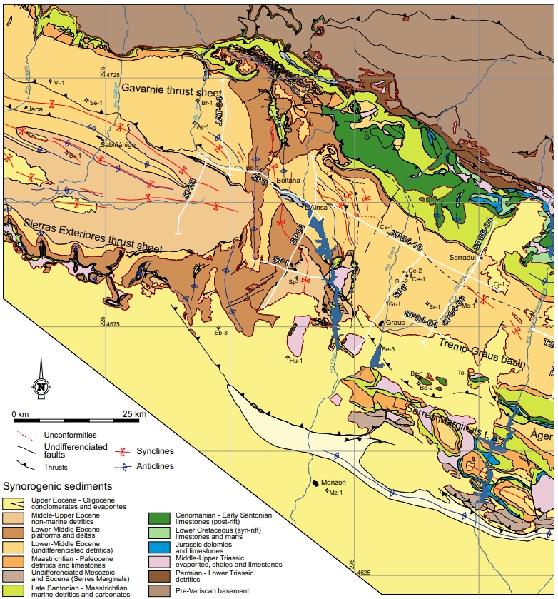
| Seismic data availability #1 | Muñoz, J. A., Mencos, J., Roca, E., Carrera, N., Gratacós, O., Ferrer, O., Fernández, O., 2018. The structure of the South-Central-Pyrenean fold and thrust belt as constrained by subsurface data. Geologica Acta, 16(4), 439-460. [link] |
| Seismic data availability #2 | Santolaria, P., Casas-Sainz, A. M., Soto, R., Casas, A., 2017. Gravity modelling to assess salt tectonics in the western end of the South Pyrenean Central Unit. Journal of the Geological Society, 174(2), 269-288. [link] |
| Seismic data availability #3 | Cámara, P., Flinch, J. F., 2017. The southern Pyrenees: a salt-based fold-and-thrust belt. In Permo-Triassic Salt Provinces of Europe, North Africa and the Atlantic Margins (pp. 395-415). Elsevier. [link] |
| Available data (Structure) #1 | Santolaria, P., Casas-Sainz, A. M., Soto, R., Casas, A., 2017. Gravity modelling to assess salt tectonics in the western end of the South Pyrenean Central Unit. Journal of the Geological Society, 174(2), 269-288. [link] |
| Available data (Structure) #2 | San José, M. L., Pocoví, J. A., 1982. Nota preliminar sobre la presencia de estructuras fluidales en las ofitas del área de Estopiñán (provincia de Huesca). Acta geológica hispánica, 17(4), 227-233. [link] |
| Available data (Structure) #3 | Cámara, P., Flinch, J. F., 2017. The southern Pyrenees: a salt-based fold-and-thrust belt. In Permo-Triassic Salt Provinces of Europe, North Africa and the Atlantic Margins (pp. 395-415). Elsevier. [link] |
| Available data (Structure) #4 | Muñoz, J. A., Mencos, J., Roca, E., Carrera, N., Gratacós, O., Ferrer, O., Fernández, O., 2018. The structure of the South-Central-Pyrenean fold and thrust belt as constrained by subsurface data. Geologica Acta, 16(4), 439-460. [link] |
| Available data (Structure) #5 | n.a. |
| Available data (Structure) #6 | n.a. |
| Available data (Analogue modelling) #1 | n.a. |
| Available data (Analogue modelling) #2 | n.a. |
| Available data (Analogue modelling) #3 | n.a. |
| Available data (Gravimetry – Tomography) #1 | Santolaria, P., Casas-Sainz, A. M., Soto, R., Pinto, V., Casas, A., 2014. The Naval diapir (Southern Pyrenees): Geometry of a salt wall associated with thrusting at an oblique ramp. Tectonophysics, 637, 30-44. [link] |
| Available data (Gravimetry – Tomography) #2 | Santolaria, P., Casas-Sainz, A. M., Soto, R., Casas, A., 2017. Gravity modelling to assess salt tectonics in the western end of the South Pyrenean Central Unit. Journal of the Geological Society, 174(2), 269-288. [link] |
| Available data (Gravimetry – Tomography) #3 | Casas, A., Santolaria, P., Rivero, L., Casas-Sainz, A., Himi, M., Pinto, V., Sendrós, A., 2016. The gravity method: new challenges for delineation diapiric structures in north-east Spain. First Break, 34(8). [link] |
| Available data (Geochemistry) #1 | Pérez, C., Lambán, L. J., 2009. Primeros resultados obtenidos sobre el funcionamiento hidrogeológico de la Lagunas de Estaña y su relación con el acuífero de Estopiñán (Huesca, España). Boletín Geológico y Minero, 120 (3): 443-458. [link] |
| Available data (Geochemistry) #2 | Salvany, J. M., Bastida, J., 2004. Análisis litoestratigráfico del Keuper surpirenaico central. Revista de la Sociedad Geológica de España, 17(1), 3-26. [link] |
| Available data (Geochemistry) #3 | n.a. |
| Available data (Geochemistry) #4 | n.a. |
| Available data (Petrophysics) #1 | Santolaria, P., Casas-Sainz, A. M., Soto, R., Casas, A., 2017. Gravity modelling to assess salt tectonics in the western end of the South Pyrenean Central Unit. Journal of the Geological Society, 174(2), 269-288. [link] |
| Available data (Petrophysics) #2 | Muñoz, J. A., Beamud, E., Fernández, O., Arbués, P., Dinarès‐Turell, J., Poblet, J., 2013. The Ainsa Fold and thrust oblique zone of the central Pyrenees: Kinematics of a curved contractional system from paleomagnetic and structural data. Tectonics, 32(5), 1142-1175. [link] |
| IGME Geological Map (MAGNA50) Sheet number | 289-Benabarre. [link] |
| Other Maps #1 (source) | Muñoz, J. A., Mencos, J., Roca, E., Carrera, N., Gratacós, O., Ferrer, O., Fernández, O., 2018. The structure of the South-Central-Pyrenean fold and thrust belt as constrained by subsurface data. Geologica Acta, 16(4), 439-460. [link] |
| Other Maps #2 (source) | Santolaria, P., Casas-Sainz, A. M., Soto, R., Casas, A., 2017. Gravity modelling to assess salt tectonics in the western end of the South Pyrenean Central Unit. Journal of the Geological Society, 174(2), 269-288. [link] |
| Other related references #1 | Morellon, M., Valero‐Garces, B. L. A. S., Anselmetti, F., Ariztegui, D., Schnellmann, M., Moreno, A. N. A., …, Corella, J. P., 2009. Late Quaternary deposition and facies model for karstic Lake Estanya (North‐eastern Spain). Sedimentology, 56(5), 1505-1534. [link] |
| Other related references #2 | Sancho-Marcén, C., 1988. El Polje de Saganta (Sierras Exteriores pirenaicas, prov. de Huesca). Cuaternario y Geomorfologıa, 2(1-4), 107-113. [link] |
| Other related references #3 | n.a. |
| Other related references #4 | n.a. |
Well and Seismic Data
| UNIQUE_ID | 71 |
| Seismic survey name #1 | 11D1-ND |
| Across structure? #1 | Y |
| Seismic profile ID (IGME) #1 | 10149 |
| Seismic profile code #1 | 14777 |
| Seismic profile name #1 | ND-63 |
| Seismic survey year #1 | 1962 |
| Data repository #1 | SIGEOF Data Catalogue (Private access section). ©Instituto Geológico y Minero de España (IGME). https://info.igme.es/SIGEOF/ |
| Length (km) #1 | 13.34 |
| Seismic survey name #2 | 11D1-ND |
| Across structure? #2 | Y |
| Seismic profile ID (IGME) #2 | 10148 |
| Seismic profile code #2 | 14776 |
| Seismic profile name #2 | ND-64 |
| Seismic survey year #2 | 1962 |
| Data repository #2 | SIGEOF Data Catalogue (Section available under request). ©Instituto Geológico y Minero de España (IGME). https://info.igme.es/SIGEOF/ |
| Length (km) #2 | 13.83 |
| Seismic survey name #3 | 0116A80U |
| Across structure? #3 | Y |
| Seismic profile ID (IGME) #3 | 5544 |
| Seismic profile code #3 | 8446 |
| Seismic profile name #3 | SP-42 |
| Seismic survey year #3 | 1980 |
| Data repository #3 | SIGEOF Data Catalogue (Private access section). ©Instituto Geológico y Minero de España (IGME). https://info.igme.es/SIGEOF/ |
| Length (km) #3 | 8.88 |
| Seismic survey name #4 | 11D1-SP |
| Across structure? #4 | Y |
| Seismic profile ID (IGME) #4 | 10251 |
| Seismic profile code #4 | 14879 |
| Seismic profile name #4 | SP-8 |
| Seismic survey year #4 | 1979 |
| Data repository #4 | SIGEOF Data Catalogue (Section available under request). ©Instituto Geológico y Minero de España (IGME). https://info.igme.es/SIGEOF/ |
| Length (km) #4 | 21.87 |
| Seismic survey name #5 | 0116A80G |
| Across structure? #5 | Y |
| Seismic profile ID (IGME) #5 | 5382 |
| Seismic profile code #5 | 7750 |
| Seismic profile name #5 | SP-42 |
| Seismic survey year #5 | 1980 |
| Data repository #5 | SIGEOF Data Catalogue (Private access section). ©Instituto Geológico y Minero de España (IGME). https://info.igme.es/SIGEOF/ |
| Length (km) #5 | 9.41 |
| Seismic survey name #6 | 11D-ST-152 |
| Across structure? #6 | Y |
| Seismic profile ID (IGME) #6 | 14106 |
| Seismic profile code #6 | 18841 |
| Seismic profile name #6 | ND-80 |
| Seismic survey year #6 | 1962 |
| Data repository #6 | SIGEOF Data Catalogue (Private access section). ©Instituto Geológico y Minero de España (IGME). https://info.igme.es/SIGEOF/ |
| Length (km) #6 | 9.79 |
| Seismic survey name #7 | 11D1-SP |
| Across structure? #7 | N (within 3km) |
| Seismic profile ID (IGME) #7 | 10251 |
| Seismic profile code #7 | 14879 |
| Seismic profile name #7 | SP-8 |
| Seismic survey year #7 | 1979 |
| Data repository #7 | SIGEOF Data Catalogue (Section available under request). ©Instituto Geológico y Minero de España (IGME). https://info.igme.es/SIGEOF/ |
| Length (km) #7 | 21.87 |
| Seismic survey name #8 | 11D1-SP |
| Across structure? #8 | N (within 3km) |
| Seismic profile ID (IGME) #8 | 10266 |
| Seismic profile code #8 | 14894 |
| Seismic profile name #8 | SP-40 |
| Seismic survey year #8 | 1962 |
| Data repository #8 | SIGEOF Data Catalogue (Section available under request). ©Instituto Geológico y Minero de España (IGME). https://info.igme.es/SIGEOF/ |
| Length (km) #8 | 7.80 |
| Seismic survey name #9 | 11D1-ND |
| Across structure? #9 | N (within 3km) |
| Seismic profile ID (IGME) #9 | 10148 |
| Seismic profile code #9 | 14776 |
| Seismic profile name #9 | ND-64 |
| Seismic survey year #9 | 1962 |
| Data repository #9 | SIGEOF Data Catalogue (Section available under request). ©Instituto Geológico y Minero de España (IGME). https://info.igme.es/SIGEOF/ |
| Length (km) #9 | 13.83 |
| Seismic survey name #10 | 12D3-TR |
| Across structure? #10 | N (within 3km) |
| Seismic profile ID (IGME) #10 | 10506 |
| Seismic profile code #10 | 15135 |
| Seismic profile name #10 | TR-56 |
| Seismic survey year #10 | 1978 |
| Data repository #10 | SIGEOF Data Catalogue (Section available under request). ©Instituto Geológico y Minero de España (IGME). https://info.igme.es/SIGEOF/ |
| Length (km) #10 | 41.42 |
| Seismic survey name #11 | 11D1-SP |
| Across structure? #11 | N (within 3km) |
| Seismic profile ID (IGME) #11 | 10265 |
| Seismic profile code #11 | 14893 |
| Seismic profile name #11 | SP-42 |
| Seismic survey year #11 | 1979 |
| Data repository #11 | SIGEOF Data Catalogue (Section available under request). ©Instituto Geológico y Minero de España (IGME). https://info.igme.es/SIGEOF/ |
| Length (km) #11 | 7.77 |
| Seismic survey name #12 | 11D2-TR |
| Across structure? #12 | N (within 3km) |
| Seismic profile ID (IGME) #12 | 10289 |
| Seismic profile code #12 | 14917 |
| Seismic profile name #12 | TR-58 |
| Seismic survey year #12 | 1978 |
| Data repository #12 | SIGEOF Data Catalogue (Section available under request). ©Instituto Geológico y Minero de España (IGME). https://info.igme.es/SIGEOF/ |
| Length (km) #12 | 13.64 |
| Seismic survey name #13 | 0116A80U |
| Across structure? #13 | N (within 3km) |
| Seismic profile ID (IGME) #13 | 5543 |
| Seismic profile code #13 | 8445 |
| Seismic profile name #13 | SP-40 |
| Seismic survey year #13 | 1980 |
| Data repository #13 | SIGEOF Data Catalogue (Private access section). ©Instituto Geológico y Minero de España (IGME). https://info.igme.es/SIGEOF/ |
| Length (km) #13 | 9.49 |
| Seismic survey name #14 | 0116A80G |
| Across structure? #14 | N (within 3km) |
| Seismic profile ID (IGME) #14 | 5381 |
| Seismic profile code #14 | 7749 |
| Seismic profile name #14 | SP-40 |
| Seismic survey year #14 | 1980 |
| Data repository #14 | SIGEOF Data Catalogue (Private access section). ©Instituto Geológico y Minero de España (IGME). https://info.igme.es/SIGEOF/ |
| Length (km) #14 | 9.59 |
| Seismic survey name #15 | 0116A80U |
| Across structure? #15 | N (within 3km) |
| Seismic profile ID (IGME) #15 | 5544 |
| Seismic profile code #15 | 8446 |
| Seismic profile name #15 | SP-42 |
| Seismic survey year #15 | 1980 |
| Data repository #15 | SIGEOF Data Catalogue (Private access section). ©Instituto Geológico y Minero de España (IGME). https://info.igme.es/SIGEOF/ |
| Length (km) #15 | 8.88 |
| Seismic survey name #16 | 0116A80G |
| Across structure? #16 | N (within 3km) |
| Seismic profile ID (IGME) #16 | 5382 |
| Seismic profile code #16 | 7750 |
| Seismic profile name #16 | SP-42 |
| Seismic survey year #16 | 1980 |
| Data repository #16 | SIGEOF Data Catalogue (Private access section). ©Instituto Geológico y Minero de España (IGME). https://info.igme.es/SIGEOF/ |
| Length (km) #16 | 9.41 |
| Seismic survey name #17 | DHLS |
| Across structure? #17 | N (within 3km) |
| Seismic profile ID (IGME) #17 | 5631 |
| Seismic profile code #17 | 8655 |
| Seismic profile name #17 | HL-25 |
| Seismic survey year #17 | |
| Data repository #17 | SIGEOF Data Catalogue (Private access section). ©Instituto Geológico y Minero de España (IGME). https://info.igme.es/SIGEOF/ |
| Length (km) #17 | 12.61 |
| Seismic survey name #18 | 11D1-ND |
| Across structure? #18 | N (within 3km) |
| Seismic profile ID (IGME) #18 | 10195 |
| Seismic profile code #18 | 14823 |
| Seismic profile name #18 | ND-161 |
| Seismic survey year #18 | 1962 |
| Data repository #18 | SIGEOF Data Catalogue (Private access section). ©Instituto Geológico y Minero de España (IGME). https://info.igme.es/SIGEOF/ |
| Length (km) #18 | 3.25 |
| Seismic survey name #19 | 11D-ST-152 |
| Across structure? #19 | N (within 3km) |
| Seismic profile ID (IGME) #19 | 14106 |
| Seismic profile code #19 | 18841 |
| Seismic profile name #19 | ND-80 |
| Seismic survey year #19 | 1962 |
| Data repository #19 | SIGEOF Data Catalogue (Private access section). ©Instituto Geológico y Minero de España (IGME). https://info.igme.es/SIGEOF/ |
| Length (km) #19 | 9.79 |
| Seismic survey name #20 | 11D1-ND |
| Across structure? #20 | N (within 3km) |
| Seismic profile ID (IGME) #20 | 10149 |
| Seismic profile code #20 | 14777 |
| Seismic profile name #20 | ND-63 |
| Seismic survey year #20 | 1962 |
| Data repository #20 | SIGEOF Data Catalogue (Private access section). ©Instituto Geológico y Minero de España (IGME). https://info.igme.es/SIGEOF/ |
| Length (km) #20 | 13.34 |
| Seismic survey name #21 | 11D-ST-152 |
| Across structure? #21 | N (within 3km) |
| Seismic profile ID (IGME) #21 | 14105 |
| Seismic profile code #21 | 18840 |
| Seismic profile name #21 | ND-90 |
| Seismic survey year #21 | 1962 |
| Data repository #21 | SIGEOF Data Catalogue (Private access section). ©Instituto Geológico y Minero de España (IGME). https://info.igme.es/SIGEOF/ |
| Length (km) #21 | 16.61 |
| Borehole name #1 | ESTOPIÑAN |
| Company #1 | CONFEDERACION HIDROGRAFICA DEL EBRO |
| Traget #1 | HYDROGEOLOGY |
| Across structure? #1 | N (within 5 km) |
| Borehole name #2 | |
| Company #2 | |
| Traget #2 | |
| Across structure? #2 | |
| Borehole name #3 | |
| Company #3 | |
| Traget #3 | |
| Across structure? #3 | |
| Borehole name #4 | |
| Company #4 | |
| Traget #4 | |
| Across structure? #4 | |
| Borehole name #5 | |
| Company #5 | |
| Traget #5 | |
| Across structure? #5 | |
| Borehole name #6 | |
| Company #6 | |
| Traget #6 | |
| Across structure? #6 | |
| Borehole name #7 | |
| Company #7 | |
| Traget #7 | |
| Across structure? #7 | |
| Borehole name #8 | |
| Company #8 | |
| Traget #8 | |
| Across structure? #8 | |
| Borehole name #9 | |
| Company #9 | |
| Traget #9 | |
| Across structure? #9 | |
| Borehole name #10 | |
| Company #10 | |
| Traget #10 | |
| Across structure? #10 | |
| Borehole name #11 | |
| Company #11 | |
| Traget #11 | |
| Across structure? #11 | |
| Borehole name #12 | |
| Company #12 | |
| Traget #12 | |
| Across structure? #12 | |
| Borehole name #13 | |
| Company #13 | |
| Traget #13 | |
| Across structure? #13 | |
| Borehole name #14 | |
| Company #14 | |
| Traget #14 | |
| Across structure? #14 | |
| Borehole name #15 | |
| Company #15 | |
| Traget #15 | |
| Across structure? #15 |
Geographical Data (EPSG:4326 - WGS 84)
| UNIQUE_ID | 71 |
| X Centroid (Structure shape) | 0.521651 |
| Y Centroid (Structure shape) | 0.521651 |
| Xmin (Structure shape) | 0.416388 |
| Xmax (Structure shape) | 0.641561 |
| Ymin (Structure shape) | 41.920753 |
| Ymax (Structure shape) | 42.060863 |
| Xmin seismic line #1 | 0.395729 |
| Xmax seismic line #1 | 0.494656 |
| Ymin seismic line #1 | 42.003063 |
| Ymax seismic line #1 | 42.087184 |
| Xmin seismic line #2 | 0.431154 |
| Xmax seismic line #2 | 0.478279 |
| Ymin seismic line #2 | 42.054254 |
| Ymax seismic line #2 | 42.163132 |
| Xmin seismic line #3 | 0.459851 |
| Xmax seismic line #3 | 0.483295 |
| Ymin seismic line #3 | 42.052524 |
| Ymax seismic line #3 | 42.130472 |
| Xmin seismic line #4 | 0.521535 |
| Xmax seismic line #4 | 0.555573 |
| Ymin seismic line #4 | 42.007586 |
| Ymax seismic line #4 | 42.194336 |
| Xmin seismic line #5 | 0.459851 |
| Xmax seismic line #5 | 0.485322 |
| Ymin seismic line #5 | 42.052524 |
| Ymax seismic line #5 | 42.134969 |
| Xmin seismic line #6 | 0.461794 |
| Xmax seismic line #6 | 0.487656 |
| Ymin seismic line #6 | 41.961974 |
| Ymax seismic line #6 | 42.044886 |
| Xmin seismic line #7 | 0.521535 |
| Xmax seismic line #7 | 0.555573 |
| Ymin seismic line #7 | 42.007586 |
| Ymax seismic line #7 | 42.194336 |
| Xmin seismic line #8 | 0.422882 |
| Xmax seismic line #8 | 0.462334 |
| Ymin seismic line #8 | 42.069837 |
| Ymax seismic line #8 | 42.132964 |
| Xmin seismic line #9 | 0.431154 |
| Xmax seismic line #9 | 0.478279 |
| Ymin seismic line #9 | 42.054254 |
| Ymax seismic line #9 | 42.163132 |
| Xmin seismic line #10 | 0.662980 |
| Xmax seismic line #10 | 1.161839 |
| Ymin seismic line #10 | 41.941612 |
| Ymax seismic line #10 | 41.945242 |
| Xmin seismic line #11 | 0.458662 |
| Xmax seismic line #11 | 0.478691 |
| Ymin seismic line #11 | 42.063288 |
| Ymax seismic line #11 | 42.131424 |
| Xmin seismic line #12 | 0.662560 |
| Xmax seismic line #12 | 0.735795 |
| Ymin seismic line #12 | 41.930644 |
| Ymax seismic line #12 | 42.040550 |
| Xmin seismic line #13 | 0.427627 |
| Xmax seismic line #13 | 0.474628 |
| Ymin seismic line #13 | 42.071247 |
| Ymax seismic line #13 | 42.147581 |
| Xmin seismic line #14 | 0.427627 |
| Xmax seismic line #14 | 0.474628 |
| Ymin seismic line #14 | 42.071247 |
| Ymax seismic line #14 | 42.147581 |
| Xmin seismic line #15 | 0.459851 |
| Xmax seismic line #15 | 0.483295 |
| Ymin seismic line #15 | 42.052524 |
| Ymax seismic line #15 | 42.130472 |
| Xmin seismic line #16 | 0.459851 |
| Xmax seismic line #16 | 0.485322 |
| Ymin seismic line #16 | 42.052524 |
| Ymax seismic line #16 | 42.134969 |
| Xmin seismic line #17 | 0.457602 |
| Xmax seismic line #17 | 0.467993 |
| Ymin seismic line #17 | 41.869490 |
| Ymax seismic line #17 | 41.981744 |
| Xmin seismic line #18 | 0.418415 |
| Xmax seismic line #18 | 0.450659 |
| Ymin seismic line #18 | 42.085285 |
| Ymax seismic line #18 | 42.099155 |
| Xmin seismic line #19 | 0.461794 |
| Xmax seismic line #19 | 0.487656 |
| Ymin seismic line #19 | 41.961974 |
| Ymax seismic line #19 | 42.044886 |
| Xmin seismic line #20 | 0.395729 |
| Xmax seismic line #20 | 0.494656 |
| Ymin seismic line #20 | 42.003063 |
| Ymax seismic line #20 | 42.087184 |
| Xmin seismic line #21 | 0.306088 |
| Xmax seismic line #21 | 0.478564 |
| Ymin seismic line #21 | 41.940572 |
| Ymax seismic line #21 | 41.969303 |
| X borehole #1 | 0.530425 |
| Y borehole #1 | 41.977757 |
| X borehole #2 | |
| Y borehole #2 | |
| X borehole #3 | |
| Y borehole #3 | |
| X borehole #4 | |
| Y borehole #4 | |
| X borehole #5 | |
| Y borehole #5 | |
| X borehole #6 | |
| Y borehole #6 | |
| X borehole #7 | |
| Y borehole #7 | |
| X borehole #8 | |
| Y borehole #8 | |
| X borehole #9 | |
| Y borehole #9 | |
| X borehole #10 | |
| Y borehole #10 | |
| X borehole #11 | |
| Y borehole #11 | |
| X borehole #12 | |
| Y borehole #12 | |
| X borehole #13 | |
| Y borehole #13 | |
| X borehole #14 | |
| Y borehole #14 | |
| X borehole #15 | |
| Y borehole #15 |

