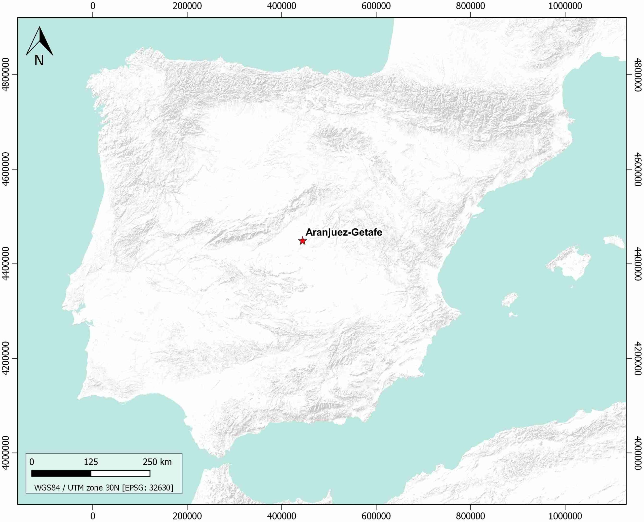
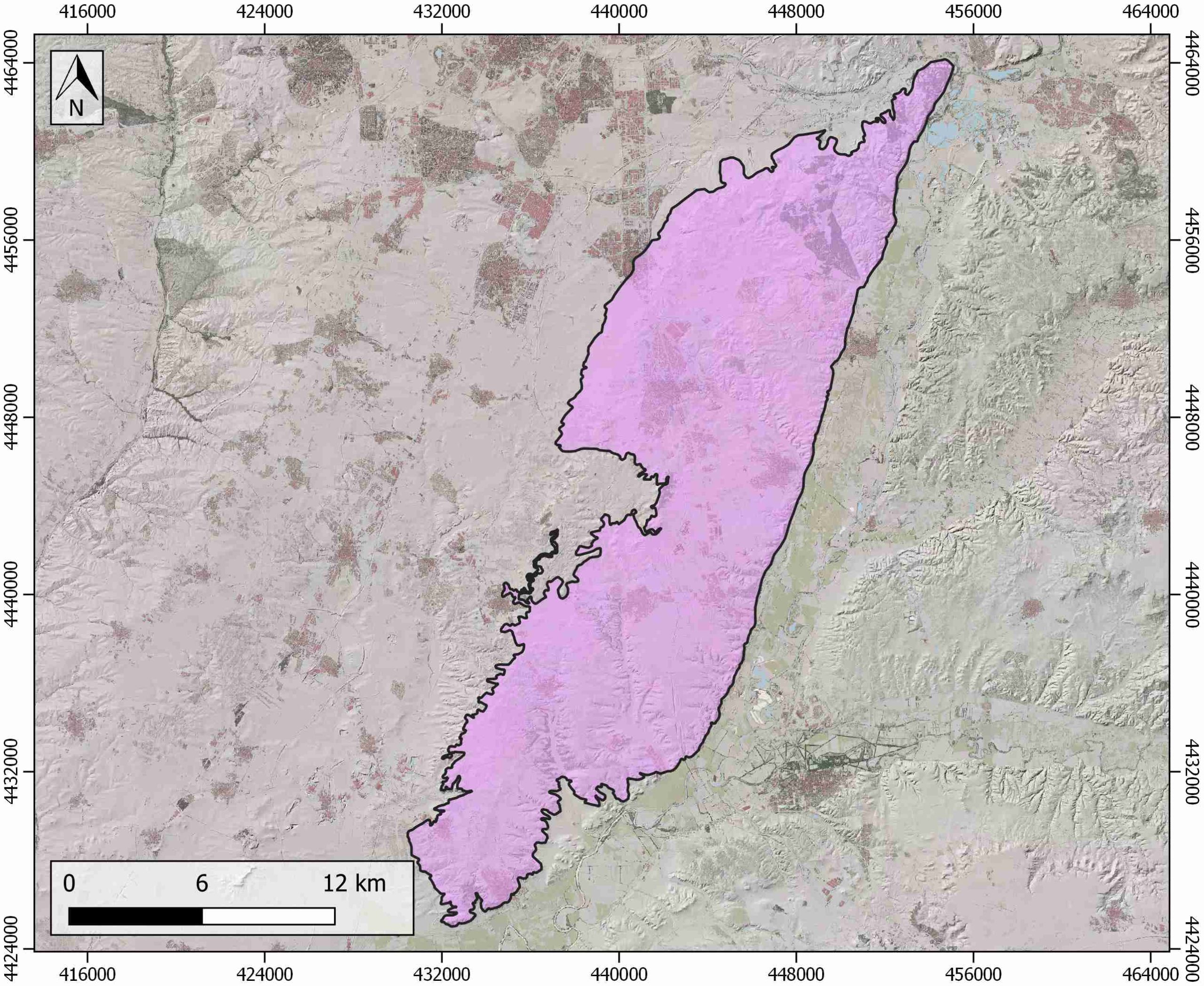
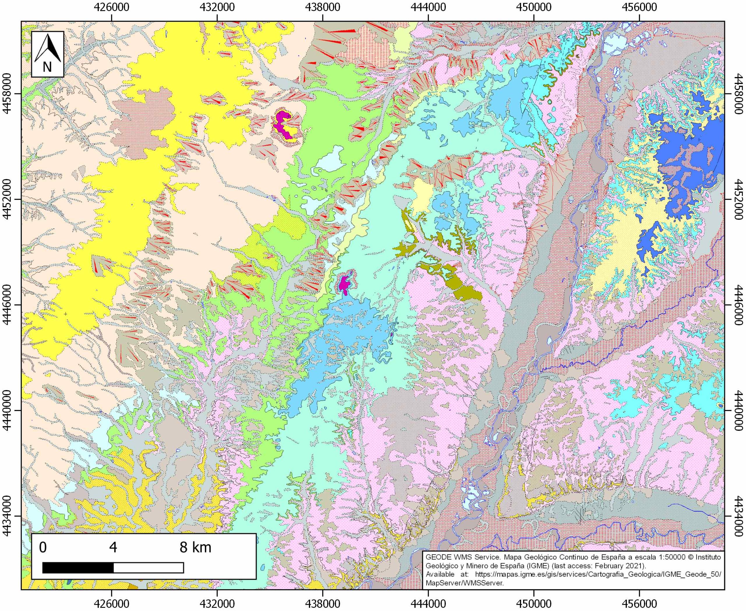
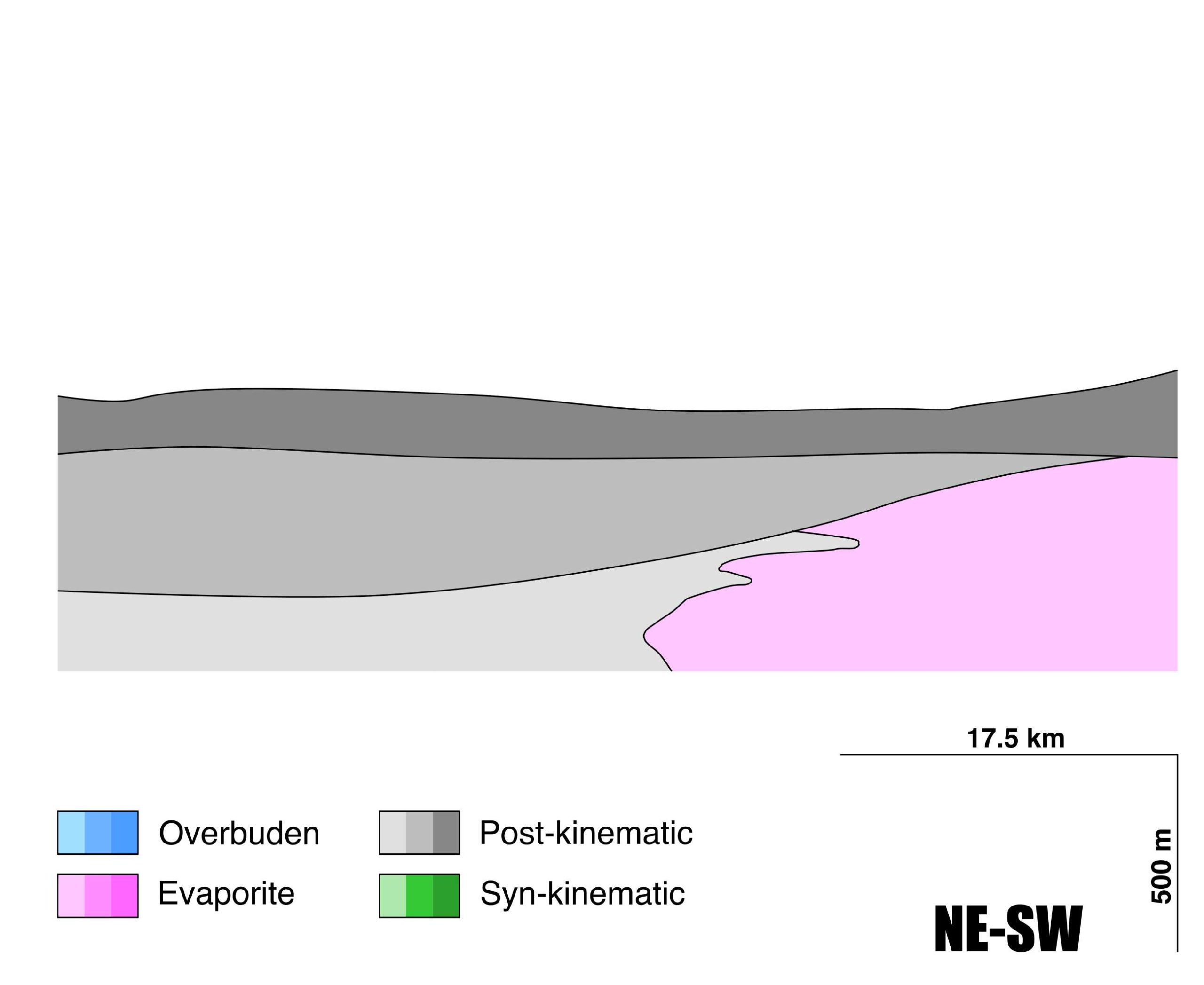
Aranjuez-Getafe
ID #121
General Information
| Structure type | Evaporite body |
| Deformed/Undeformed | Undeformed |
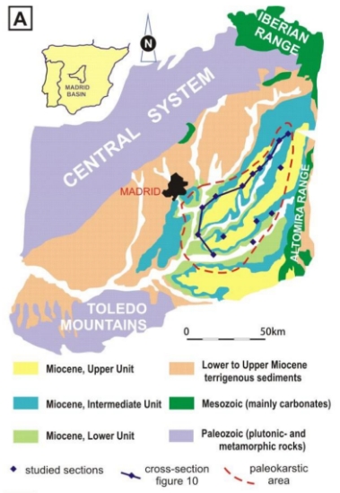
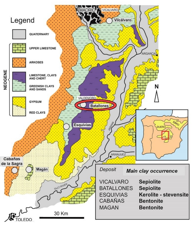
| Geological Setting | Madrid Sub-Basin, Tagus Basin |
| Outcropping/buried | Outcropping |
| Evaporite unit/s name | Unnamed |
| Evaporite unit/s age | Lower-Middle Miocene |
| Evaporite unit/s origin | Continental |
| Classif. (Hudec and Jackson, 2009) | No diapirism |
| Classif. (Jackson and Talbot, 1986) | No diapirism |
| Age of evaporite flow or deformation (when deformed) | Undeformed |
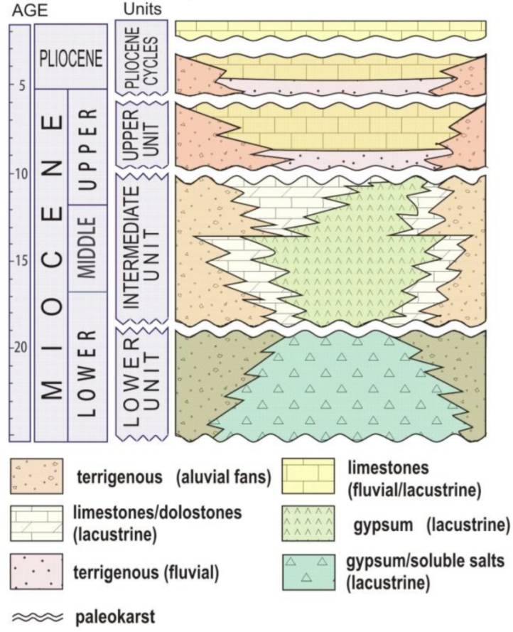
| Other comments | Decimeter-thick layers of gypsum with centimetric intercalations of claystones and marlstones. Gypsum shows meso- and macro-lenticular fabrics with a bimodal size-distribution of the lenses. Burrowing features and chert nodules are also common. |
Generic Data
| Unique ID | 121 |
| Name | Aranjuez-Getafe |
| Structure type | Evaporite body |
| Deformed/Undeformed | Undeformed |
| Buried/Outcropping | Outcropping |
| Geological setting | Tagus Basin |
| Geological Regional Setting | Madrid Basin |
| Evaporite unit/s name | Unnamed |
| Evaporite unit/s age | Lower-Middle Miocene |
| Evaporite unit/s era | Cenozoic |
| Evaporite unit/s origin | Continental (lacustrine) |
| Evaporite unit/s composition | Gypsum-Halite-Anhydrite-Shale-Marlstone |
| Post-kinematic unit/s (or post-evaporite units when evaporites are undeformed) | Middle-Upper Miocene (limestones, dolostones and marlstones) ; Upper Miocene (sandstones and red claystones) ; Upper Miocene (limestones) ; Upper Pliocene (sandstones and red claystones) ; Quaternary (alluvial and colluvial detrital deposits) |
| Post-kinematic unit/s age (or post-evaporite units when evaporites are undeformed) | Middle Miocene-Holocene |
| Classification (Hudec and Jackson, 2009) | No diapirism |
| Classification (Jackson and Talbot, 1986) | No diapirism |
| Mining activity? | Y |
| Mining activity start | Roman Empire |
| Mining activity end | Active |
| Mining galleries? | Y |
| Mining products | Gypsum |
| Mining sub-products | |
| Evaporite flow? | N |
| Age of evaporite flow | – |
| Flow or deformation triggering mechanisms | – |
| Flow-linked structures? | – |
| Halokinetic structures | – |
| Post-evaporite and pre-kinematic unit/s (overbuden) | – |
| Syn-kinematic unit/s | – |
| Available seismic profiles | ILIHA B-E / ILIHA X-A |
| Available boreholes | FINCA SAN ISIDRO / PLEITO (ESQUIVIAS) |
| Additional comments | Decimeter-thick layers of gypsum with centimetric intercalations of claystones and marlstones. Gypsum shows meso and macrolenticular fabrics with a bimodal size-distribution of the lenses. Burrowing features and chert nodules are also common. |
Mining Data
| UNIQUE_ID | 121 |
| Minning exploitations within <2km? | Y |
| Historical/Active | Active |
| Exploitation name #1 | SOLEDAD II |
| Exploitation ID (Spanish National Mining Cadastre) #1 | ca2988-11 |
| Municipality #1 | Ciempozuelos |
| Province #1 | MADRID |
| Company #1 | PLADUR GYPSUM, SA |
| Main minning Products #1 | Gypsum |
| Exploitation name #2 | SAN JOSÉ |
| Exploitation ID (Spanish National Mining Cadastre) #2 | 2815 |
| Municipality #2 | San Martín de la Vega |
| Province #2 | MADRID |
| Company #2 | YESOS HERMANOS CASTAÑO, S.L. |
| Main minning Products #2 | Gypsum |
| Exploitation name #3 | LLANO DEL OLIVAR |
| Exploitation ID (Spanish National Mining Cadastre) #3 | 187 |
| Municipality #3 | San Martín de la Vega |
| Province #3 | MADRID |
| Company #3 | YESOS SAN MARTIN, S.A. |
| Main minning Products #3 | Gypsum |
Quantitative Data
| UNIQUE_ID | 121 |
| Outcropping area (km2) | 322.24643 |
| Horizontal intersection area (km2) (when buried) | Not buried |
| Depth of intersection area (km2) (when buried) | Not buried |
| Max. Width (Km) | 44.491569 |
| Max. Length (Km) | 11.482416 |
| Max. Evaporites thickness (km) | 0.4 |
| Max. Deformation age (Ma) | – |
| Min. Deformation age (Ma) | – |
| Deformation stages | 0 |
Reference Data
| UNIQUE_ID | 121 |
| Section source | Cañaveras, J. C., Calvo, J. P., Ordóñez, S., Muñoz-Cervera, M. C., Sánchez-Moral, S., 2020. Tectono-Sedimentary Evolution of the Madrid Basin (Spain) during the Late Miocene: Data from Paleokarst Profiles in Diagenetically-Complex Continental Carbonates. Geosciences, 10(11), 433. [link] |
| Well / Borehole availability #1 | n.a. |
| Well / Borehole availability #2 | n.a. |
| Available data (Stratigraphy) #1 | Cañaveras, J. C., Calvo, J. P., Ordóñez, S., Muñoz-Cervera, M. C., Sánchez-Moral, S., 2020. Tectono-Sedimentary Evolution of the Madrid Basin (Spain) during the Late Miocene: Data from Paleokarst Profiles in Diagenetically-Complex Continental Carbonates. Geosciences, 10(11), 433. [link] |
| Available data (Stratigraphy) #2 | Calvo, J. P., Zarza, A. A., Del Cura, M. G., 1989. Models of Miocene marginal lacustrine sedimentation in response to varied depositional regimes and source areas in the Madrid Basin (Central Spain). Palaeogeography, Palaeoclimatology, Palaeoecology, 70(1-3), 199-214. [link] |
| Available data (Stratigraphy) #3 | Calvo, J. P., Pozo, M., Silva, P. G., Morales, J., 2013. Pattern of sedimentary infilling of fossil mammal traps formed in pseudokarst at Cerro de los Batallones, Madrid Basin, central Spain. Sedimentology, 60(7), 1681-1708. [link] |
| Available data (Stratigraphy) #4 | Garrote, J., Heydt, G. G., Cox, R. T., 2008. Multi-stream order analyses in basin asymmetry: a tool to discriminate the influence of neotectonics in fluvial landscape development (Madrid Basin, Central Spain). Geomorphology, 102(1), 130-144. [link] |
| Available data (Stratigraphy) #5 | Rodríguez‐Aranda, J. P., Calvo, J. P., Sanz‐Montero, M. E., 2002. Lower Miocene gypsum palaeokarst in the Madrid Basin (central Spain): dissolution diagenesis, morphological relics and karst end‐products. Sedimentology, 49(6), 1385-1400. [link] |
| Available data (Stratigraphy) #6 | Karampaglidis, T., Benito-Calvo, A., Rodés, A., Braucher, R., Pérez-González, A., Pares, J., …, Bourles, D., 2020. Pliocene endorheic-exhoreic drainage transition of the Cenozoic Madrid Basin (Central Spain). Global and Planetary Change, 194, 103295. [link] |
| Regional Stratigraphy | Cañaveras, J. C., Calvo, J. P., Ordóñez, S., Muñoz-Cervera, M. C., Sánchez-Moral, S., 2020. Tectono-Sedimentary Evolution of the Madrid Basin (Spain) during the Late Miocene: Data from Paleokarst Profiles in Diagenetically-Complex Continental Carbonates. Geosciences, 10(11), 433. [link] |
| Seismic data availability #1 | De Vicente, G., Muñoz-Martín, A., 2013. The Madrid Basin and the Central System: A tectonostratigraphic analysis from 2D seismic lines. Tectonophysics, 602, 259-285. [link] |
| Seismic data availability #2 | Diaz, J., Gallart Muset, J., Córdoba, D., Senos, L., Matias, L., Suriñach, E., …, Maguire, P., 2020. The ILIHA deep seismic sounding experiment (Iberian LIthosphere Heterogeneity and Anisotropy). DigitalCSIC – SEISDARE data repository. [link] |
| Seismic data availability #3 | n.a. |
| Available data (Structure) #1 | De Vicente, G., Muñoz-Martín, A., 2013. The Madrid Basin and the Central System: A tectonostratigraphic analysis from 2D seismic lines. Tectonophysics, 602, 259-285. [link] |
| Available data (Structure) #2 | De Vicente, G., Giner, J. L., Muñoz-Martín, A., González-Casado, J. M., Lindo, R., 1996. Determination of present-day stress tensor and neotectonic interval in the Spanish Central System and Madrid Basin, central Spain. Tectonophysics, 266(1-4), 405-424. [link] |
| Available data (Structure) #3 | De Vicente, G., González-Casado, J. M., Muñoz-Martin, A., Giner, J., Rodríguez-Pascua, M. A., 1995. Structure and Tertiary evolution of the Madrid Basin. In P. Friend & C. Dabrio (Eds.), Tertiary Basins of Spain: The Stratigraphic Record of Crustal Kinematics (World and Regional Geology, pp. 263-267). Cambridge: Cambridge University Press. [link] |
| Available data (Structure) #4 | Suárez, I., Zapatero, M. A., Martínez, R., Marina, M., 2009. Synthesis of the exploration of formations with a potential of CO2 storage: Intermediate Depression and Madrid Basin. Energy Procedia, 1(1), 2709-2715. [link] |
| Available data (Structure) #5 | del Olmo, W. M., 2019. Cambio climático, acuerdos de París y trampas geológicas donde secuestrar el CO2 en España. Revista de la Sociedad Geológica de España, 32(2), 87-106. [link] |
| Available data (Structure) #6 | n.a. |
| Available data (Analogue modelling) #1 | n.a. |
| Available data (Analogue modelling) #2 | n.a. |
| Available data (Analogue modelling) #3 | n.a. |
| Available data (Gravimetry – Tomography) #1 | Olaiz, A.J., Mantilla Pimiento, A., Muñoz Martín, A.,De Vicente Muñoz, G., 2015. Structural Achitecture of the Madrid Basin from 3D Gravity Inversion. Conference Paper 77th EAGE Conference & Exhibition 2015 . pp. 1-4. [link] |
| Available data (Gravimetry – Tomography) #2 | Calvo, J. P., Pozo, M., Silva, P. G., Morales, J., 2013. Pattern of sedimentary infilling of fossil mammal traps formed in pseudokarst at Cerro de los Batallones, Madrid Basin, central Spain. Sedimentology, 60(7), 1681-1708. [link] |
| Available data (Gravimetry – Tomography) #3 | De Vicente, G., Muñoz-Martín, A., 2013. The Madrid Basin and the Central System: A tectonostratigraphic analysis from 2D seismic lines. Tectonophysics, 602, 259-285. [link] |
| Available data (Geochemistry) #1 | Cañaveras, J. C., Calvo, J. P., Ordóñez, S., Muñoz-Cervera, M. C., Sánchez-Moral, S., 2020. Tectono-Sedimentary Evolution of the Madrid Basin (Spain) during the Late Miocene: Data from Paleokarst Profiles in Diagenetically-Complex Continental Carbonates. Geosciences, 10(11), 433. [link] |
| Available data (Geochemistry) #2 | Calvo, J. P., Pozo, M., Silva, P. G., Morales, J., 2013. Pattern of sedimentary infilling of fossil mammal traps formed in pseudokarst at Cerro de los Batallones, Madrid Basin, central Spain. Sedimentology, 60(7), 1681-1708. [link] |
| Available data (Geochemistry) #3 | Herranz, J. E., Pozo, M., 2018. Authigenic Mg-Clay Minerals Formation in Lake Margin Deposits (the Cerro de los Batallones, Madrid Basin, Spain). Minerals, 8(10), 418. [link] |
| Available data (Geochemistry) #4 | Vera, F. L., Lerman, J. C., Muller, A. B., 1981. The Madrid basin aquifer: Preliminary isotopic reconnaissance. Journal of Hydrology, 54(1-3), 151-166. [link] |
| Available data (Petrophysics) #1 | n.a. |
| Available data (Petrophysics) #2 | n.a. |
| IGME Geological Map (MAGNA50) Sheet number | 605-Aranjuez. [link] and 582-Getafe. [link] |
| Other Maps #1 (source) | Cañaveras, J. C., Calvo, J. P., Ordóñez, S., Muñoz-Cervera, M. C., Sánchez-Moral, S., 2020. Tectono-Sedimentary Evolution of the Madrid Basin (Spain) during the Late Miocene: Data from Paleokarst Profiles in Diagenetically-Complex Continental Carbonates. Geosciences, 10(11), 433. [link] |
| Other Maps #2 (source) | Herranz, J. E., Pozo, M., 2018. Authigenic Mg-Clay Minerals Formation in Lake Margin Deposits (the Cerro de los Batallones, Madrid Basin, Spain). Minerals, 8(10), 418. [link] |
| Other related references #1 | García, R., Petit-Domínguez, M. D., Rucandio, M. I., González, J. A., 2011. Provenance of loess from the Spanish central region: chemometric interpretation. Geological Magazine, 148(3), 481-491. [link] |
| Other related references #2 | Fort, R., de Buergo, M. A., Perez-Monserrat, E. M., Gomez-Heras, M., Varas-Muriel, M. J., Freire, D. M., 2013. Evolution in the use of natural building stone in Madrid, Spain. Quarterly Journal of Engineering Geology and Hydrogeology, 46(4), 421-429. [link] |
| Other related references #3 | Megias, A. G., Ordóñez-Delgado, S., Calvo, J. P., 1981. Tertiary clastic gipsum deposits in the Madrid basin (Spain). International Association of Sedimentologists. Abstracts II European Meeting. [link] |
| Other related references #4 | Menéndez Pidal, I., Mancebo Piqueras, J. A., Sanz-Pérez, E., Sáenz-Sanz, C., 2021. Influence of Hydrogeochemistry on Tunnel Drainage in Evaporitic Formations: El Regajal Tunnel Case Study (Aranjuez, Spain). Sustainability, 13, 1505. [link] |
Well and Seismic Data
| UNIQUE_ID | 121 |
| Seismic survey name #1 | ILIHA B-E |
| Across structure? #1 | N (within 3km) (withiN (within 3km) 3km) |
| Seismic profile ID (IGME) #1 | n.a. |
| Seismic profile code #1 | n.a. |
| Seismic profile name #1 | n.a. |
| Seismic survey year #1 | n.a. |
| Data repository #1 | SeisDARE Database: https://digital.csic.es/handle/10261/101997 |
| Length (km) #1 | 809.76 |
| Seismic survey name #2 | ILIHA X-A |
| Across structure? #2 | N (within 3km) (withiN (within 3km) 3km) |
| Seismic profile ID (IGME) #2 | n.a. |
| Seismic profile code #2 | n.a. |
| Seismic profile name #2 | n.a. |
| Seismic survey year #2 | n.a. |
| Data repository #2 | SeisDARE Database: https://digital.csic.es/handle/10261/101998 |
| Length (km) #2 | 781.18 |
| Seismic survey name #3 | |
| Across structure? #3 | |
| Seismic profile ID (IGME) #3 | |
| Seismic profile code #3 | |
| Seismic profile name #3 | |
| Seismic survey year #3 | |
| Data repository #3 | |
| Length (km) #3 | |
| Seismic survey name #4 | |
| Across structure? #4 | |
| Seismic profile ID (IGME) #4 | |
| Seismic profile code #4 | |
| Seismic profile name #4 | |
| Seismic survey year #4 | |
| Data repository #4 | |
| Length (km) #4 | |
| Seismic survey name #5 | |
| Across structure? #5 | |
| Seismic profile ID (IGME) #5 | |
| Seismic profile code #5 | |
| Seismic profile name #5 | |
| Seismic survey year #5 | |
| Data repository #5 | |
| Length (km) #5 | |
| Seismic survey name #6 | |
| Across structure? #6 | |
| Seismic profile ID (IGME) #6 | |
| Seismic profile code #6 | |
| Seismic profile name #6 | |
| Seismic survey year #6 | |
| Data repository #6 | |
| Length (km) #6 | |
| Seismic survey name #7 | |
| Across structure? #7 | |
| Seismic profile ID (IGME) #7 | |
| Seismic profile code #7 | |
| Seismic profile name #7 | |
| Seismic survey year #7 | |
| Data repository #7 | |
| Length (km) #7 | |
| Seismic survey name #8 | |
| Across structure? #8 | |
| Seismic profile ID (IGME) #8 | |
| Seismic profile code #8 | |
| Seismic profile name #8 | |
| Seismic survey year #8 | |
| Data repository #8 | |
| Length (km) #8 | |
| Seismic survey name #9 | |
| Across structure? #9 | |
| Seismic profile ID (IGME) #9 | |
| Seismic profile code #9 | |
| Seismic profile name #9 | |
| Seismic survey year #9 | |
| Data repository #9 | |
| Length (km) #9 | |
| Seismic survey name #10 | |
| Across structure? #10 | |
| Seismic profile ID (IGME) #10 | |
| Seismic profile code #10 | |
| Seismic profile name #10 | |
| Seismic survey year #10 | |
| Data repository #10 | |
| Length (km) #10 | |
| Seismic survey name #11 | |
| Across structure? #11 | |
| Seismic profile ID (IGME) #11 | |
| Seismic profile code #11 | |
| Seismic profile name #11 | |
| Seismic survey year #11 | |
| Data repository #11 | |
| Length (km) #11 | |
| Seismic survey name #12 | |
| Across structure? #12 | |
| Seismic profile ID (IGME) #12 | |
| Seismic profile code #12 | |
| Seismic profile name #12 | |
| Seismic survey year #12 | |
| Data repository #12 | |
| Length (km) #12 | |
| Seismic survey name #13 | |
| Across structure? #13 | |
| Seismic profile ID (IGME) #13 | |
| Seismic profile code #13 | |
| Seismic profile name #13 | |
| Seismic survey year #13 | |
| Data repository #13 | |
| Length (km) #13 | |
| Seismic survey name #14 | |
| Across structure? #14 | |
| Seismic profile ID (IGME) #14 | |
| Seismic profile code #14 | |
| Seismic profile name #14 | |
| Seismic survey year #14 | |
| Data repository #14 | |
| Length (km) #14 | |
| Seismic survey name #15 | |
| Across structure? #15 | |
| Seismic profile ID (IGME) #15 | |
| Seismic profile code #15 | |
| Seismic profile name #15 | |
| Seismic survey year #15 | |
| Data repository #15 | |
| Length (km) #15 | |
| Seismic survey name #16 | |
| Across structure? #16 | |
| Seismic profile ID (IGME) #16 | |
| Seismic profile code #16 | |
| Seismic profile name #16 | |
| Seismic survey year #16 | |
| Data repository #16 | |
| Length (km) #16 | |
| Seismic survey name #17 | |
| Across structure? #17 | |
| Seismic profile ID (IGME) #17 | |
| Seismic profile code #17 | |
| Seismic profile name #17 | |
| Seismic survey year #17 | |
| Data repository #17 | |
| Length (km) #17 | |
| Seismic survey name #18 | |
| Across structure? #18 | |
| Seismic profile ID (IGME) #18 | |
| Seismic profile code #18 | |
| Seismic profile name #18 | |
| Seismic survey year #18 | |
| Data repository #18 | |
| Length (km) #18 | |
| Seismic survey name #19 | |
| Across structure? #19 | |
| Seismic profile ID (IGME) #19 | |
| Seismic profile code #19 | |
| Seismic profile name #19 | |
| Seismic survey year #19 | |
| Data repository #19 | |
| Length (km) #19 | |
| Seismic survey name #20 | |
| Across structure? #20 | |
| Seismic profile ID (IGME) #20 | |
| Seismic profile code #20 | |
| Seismic profile name #20 | |
| Seismic survey year #20 | |
| Data repository #20 | |
| Length (km) #20 | |
| Seismic survey name #21 | |
| Across structure? #21 | |
| Seismic profile ID (IGME) #21 | |
| Seismic profile code #21 | |
| Seismic profile name #21 | |
| Seismic survey year #21 | |
| Data repository #21 | |
| Length (km) #21 | |
| Borehole name #1 | FINCA SAN ISIDRO |
| Company #1 | TRAGSA |
| Traget #1 | HYDROGEOLOGY |
| Across structure? #1 | N (within 5 km) |
| Borehole name #2 | PLEITO (ESQUIVIAS) |
| Company #2 | TRAGSA |
| Traget #2 | HYDROGEOLOGY |
| Across structure? #2 | N (within 5 km) |
| Borehole name #3 | |
| Company #3 | |
| Traget #3 | |
| Across structure? #3 | |
| Borehole name #4 | |
| Company #4 | |
| Traget #4 | |
| Across structure? #4 | |
| Borehole name #5 | |
| Company #5 | |
| Traget #5 | |
| Across structure? #5 | |
| Borehole name #6 | |
| Company #6 | |
| Traget #6 | |
| Across structure? #6 | |
| Borehole name #7 | |
| Company #7 | |
| Traget #7 | |
| Across structure? #7 | |
| Borehole name #8 | |
| Company #8 | |
| Traget #8 | |
| Across structure? #8 | |
| Borehole name #9 | |
| Company #9 | |
| Traget #9 | |
| Across structure? #9 | |
| Borehole name #10 | |
| Company #10 | |
| Traget #10 | |
| Across structure? #10 | |
| Borehole name #11 | |
| Company #11 | |
| Traget #11 | |
| Across structure? #11 | |
| Borehole name #12 | |
| Company #12 | |
| Traget #12 | |
| Across structure? #12 | |
| Borehole name #13 | |
| Company #13 | |
| Traget #13 | |
| Across structure? #13 | |
| Borehole name #14 | |
| Company #14 | |
| Traget #14 | |
| Across structure? #14 | |
| Borehole name #15 | |
| Company #15 | |
| Traget #15 | |
| Across structure? #15 |
Geographical Data (EPSG:4326 - WGS 84)
| UNIQUE_ID | 121 |
| X Centroid (Structure shape) | -3.673751 |
| Y Centroid (Structure shape) | -3.673751 |
| Xmin (Structure shape) | -3.814849 |
| Xmax (Structure shape) | -3.528444 |
| Ymin (Structure shape) | 39.972500 |
| Ymax (Structure shape) | 40.326777 |
| Xmin seismic line #1 | -8.811771 |
| Xmax seismic line #1 | -0.242737 |
| Ymin seismic line #1 | 38.531666 |
| Ymax seismic line #1 | 41.687723 |
| Xmin seismic line #2 | -4.805725 |
| Xmax seismic line #2 | -2.410217 |
| Ymin seismic line #2 | 36.528503 |
| Ymax seismic line #2 | 43.318909 |
| Xmin seismic line #3 | |
| Xmax seismic line #3 | |
| Ymin seismic line #3 | |
| Ymax seismic line #3 | |
| Xmin seismic line #4 | |
| Xmax seismic line #4 | |
| Ymin seismic line #4 | |
| Ymax seismic line #4 | |
| Xmin seismic line #5 | |
| Xmax seismic line #5 | |
| Ymin seismic line #5 | |
| Ymax seismic line #5 | |
| Xmin seismic line #6 | |
| Xmax seismic line #6 | |
| Ymin seismic line #6 | |
| Ymax seismic line #6 | |
| Xmin seismic line #7 | |
| Xmax seismic line #7 | |
| Ymin seismic line #7 | |
| Ymax seismic line #7 | |
| Xmin seismic line #8 | |
| Xmax seismic line #8 | |
| Ymin seismic line #8 | |
| Ymax seismic line #8 | |
| Xmin seismic line #9 | |
| Xmax seismic line #9 | |
| Ymin seismic line #9 | |
| Ymax seismic line #9 | |
| Xmin seismic line #10 | |
| Xmax seismic line #10 | |
| Ymin seismic line #10 | |
| Ymax seismic line #10 | |
| Xmin seismic line #11 | |
| Xmax seismic line #11 | |
| Ymin seismic line #11 | |
| Ymax seismic line #11 | |
| Xmin seismic line #12 | |
| Xmax seismic line #12 | |
| Ymin seismic line #12 | |
| Ymax seismic line #12 | |
| Xmin seismic line #13 | |
| Xmax seismic line #13 | |
| Ymin seismic line #13 | |
| Ymax seismic line #13 | |
| Xmin seismic line #14 | |
| Xmax seismic line #14 | |
| Ymin seismic line #14 | |
| Ymax seismic line #14 | |
| Xmin seismic line #15 | |
| Xmax seismic line #15 | |
| Ymin seismic line #15 | |
| Ymax seismic line #15 | |
| Xmin seismic line #16 | |
| Xmax seismic line #16 | |
| Ymin seismic line #16 | |
| Ymax seismic line #16 | |
| Xmin seismic line #17 | |
| Xmax seismic line #17 | |
| Ymin seismic line #17 | |
| Ymax seismic line #17 | |
| Xmin seismic line #18 | |
| Xmax seismic line #18 | |
| Ymin seismic line #18 | |
| Ymax seismic line #18 | |
| Xmin seismic line #19 | |
| Xmax seismic line #19 | |
| Ymin seismic line #19 | |
| Ymax seismic line #19 | |
| Xmin seismic line #20 | |
| Xmax seismic line #20 | |
| Ymin seismic line #20 | |
| Ymax seismic line #20 | |
| Xmin seismic line #21 | |
| Xmax seismic line #21 | |
| Ymin seismic line #21 | |
| Ymax seismic line #21 | |
| X borehole #1 | -3.808945 |
| Y borehole #1 | 40.051260 |
| X borehole #2 | -3.771437 |
| Y borehole #2 | 40.111249 |
| X borehole #3 | |
| Y borehole #3 | |
| X borehole #4 | |
| Y borehole #4 | |
| X borehole #5 | |
| Y borehole #5 | |
| X borehole #6 | |
| Y borehole #6 | |
| X borehole #7 | |
| Y borehole #7 | |
| X borehole #8 | |
| Y borehole #8 | |
| X borehole #9 | |
| Y borehole #9 | |
| X borehole #10 | |
| Y borehole #10 | |
| X borehole #11 | |
| Y borehole #11 | |
| X borehole #12 | |
| Y borehole #12 | |
| X borehole #13 | |
| Y borehole #13 | |
| X borehole #14 | |
| Y borehole #14 | |
| X borehole #15 | |
| Y borehole #15 |

