General Information
| Structure type | Evaporite-cored anticline |
| Deformed/Undeformed | Deformed |
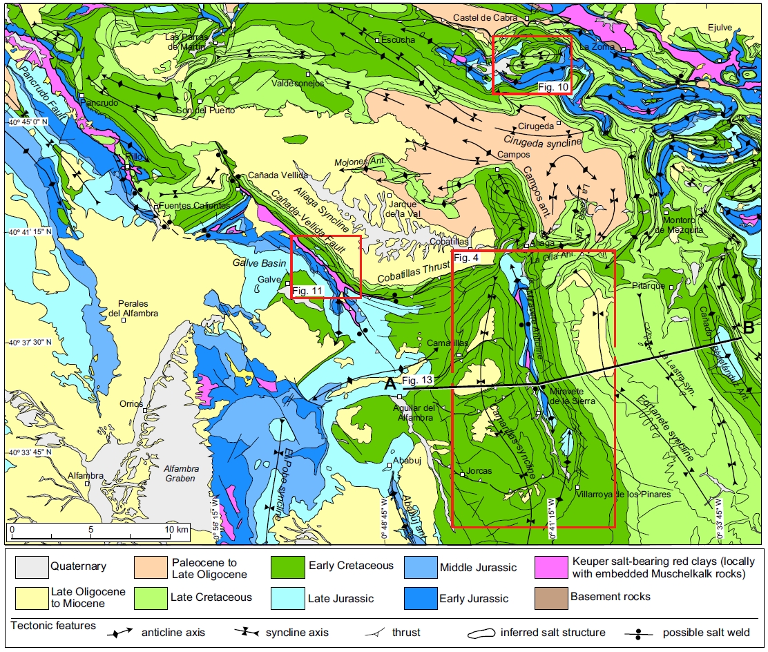
| Geological Setting | Iberian Range, Maestrat Basin |
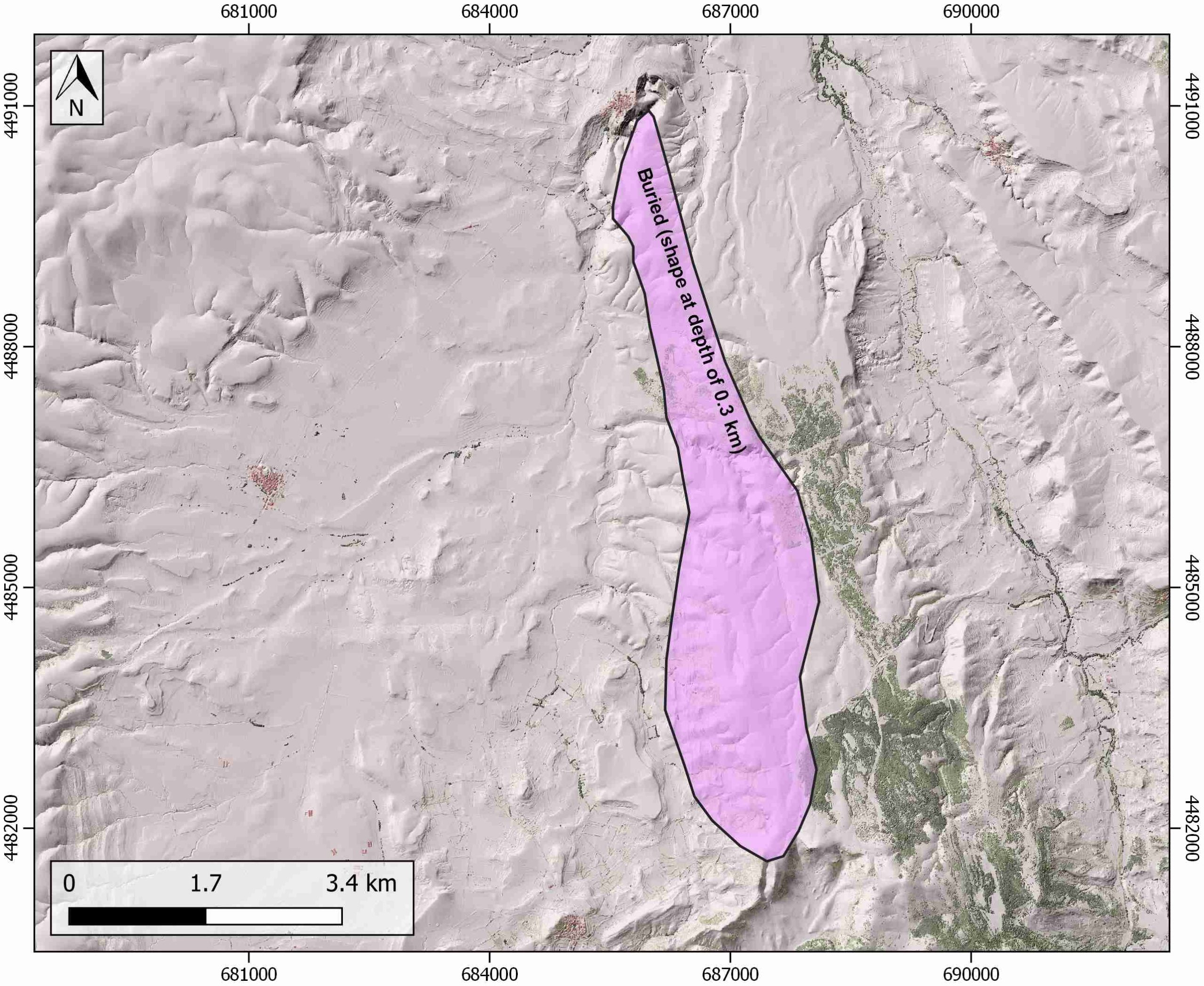
| Outcropping/buried | Buried |
| Evaporite unit/s name | Keuper facies |
| Evaporite unit/s age | Carnian-Rhaetian (Upper Triassic) |
| Evaporite unit/s origin | Marine |
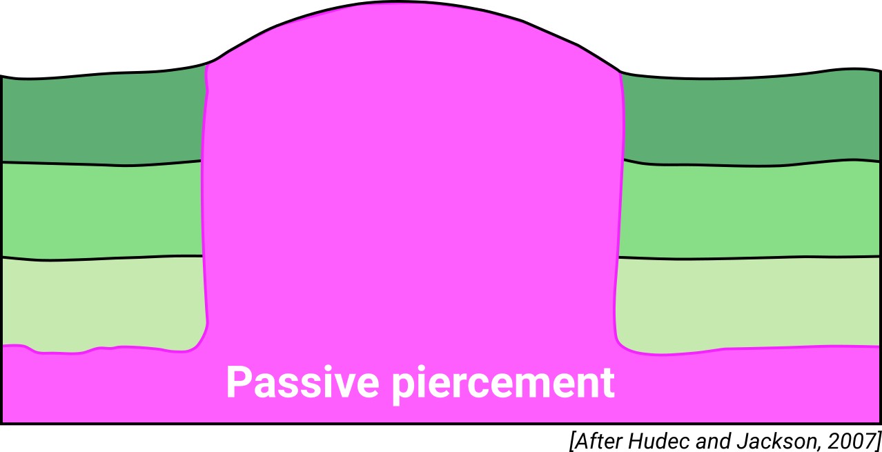
| Classif. (Hudec and Jackson, 2009) | Passive piercement |
| Classif. (Jackson and Talbot, 1986) | Salt anticline |
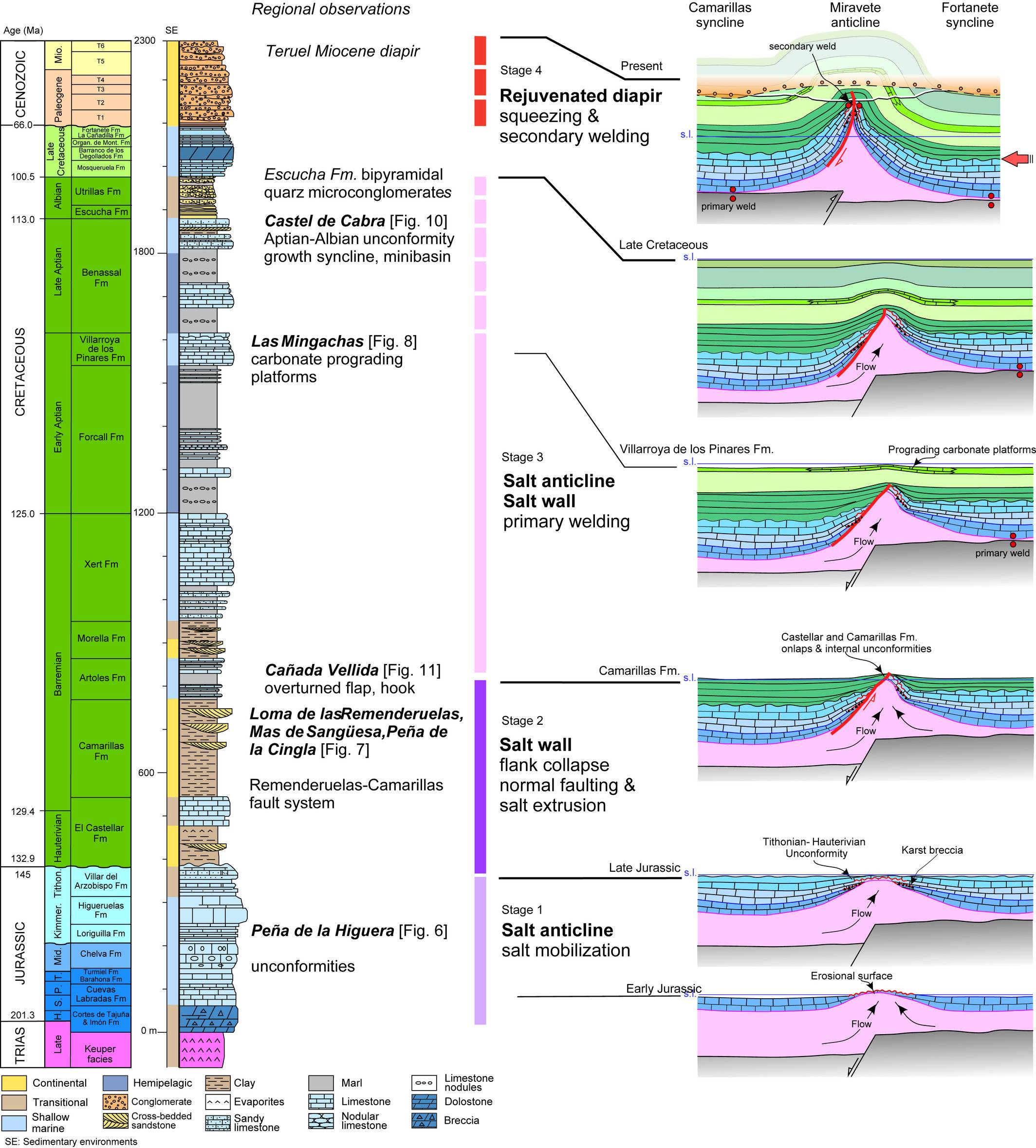
| Age of evaporite flow or deformation (when deformed) | Lower Cretaceous, Miocene, Upper Cretaceous to Oligocene, Upper Jurassic |
| Other comments | Most active diapiric growth in the Maestrat basin match with eastward drift of the Iberian microplate. |
Generic Data
| Unique ID | 145 |
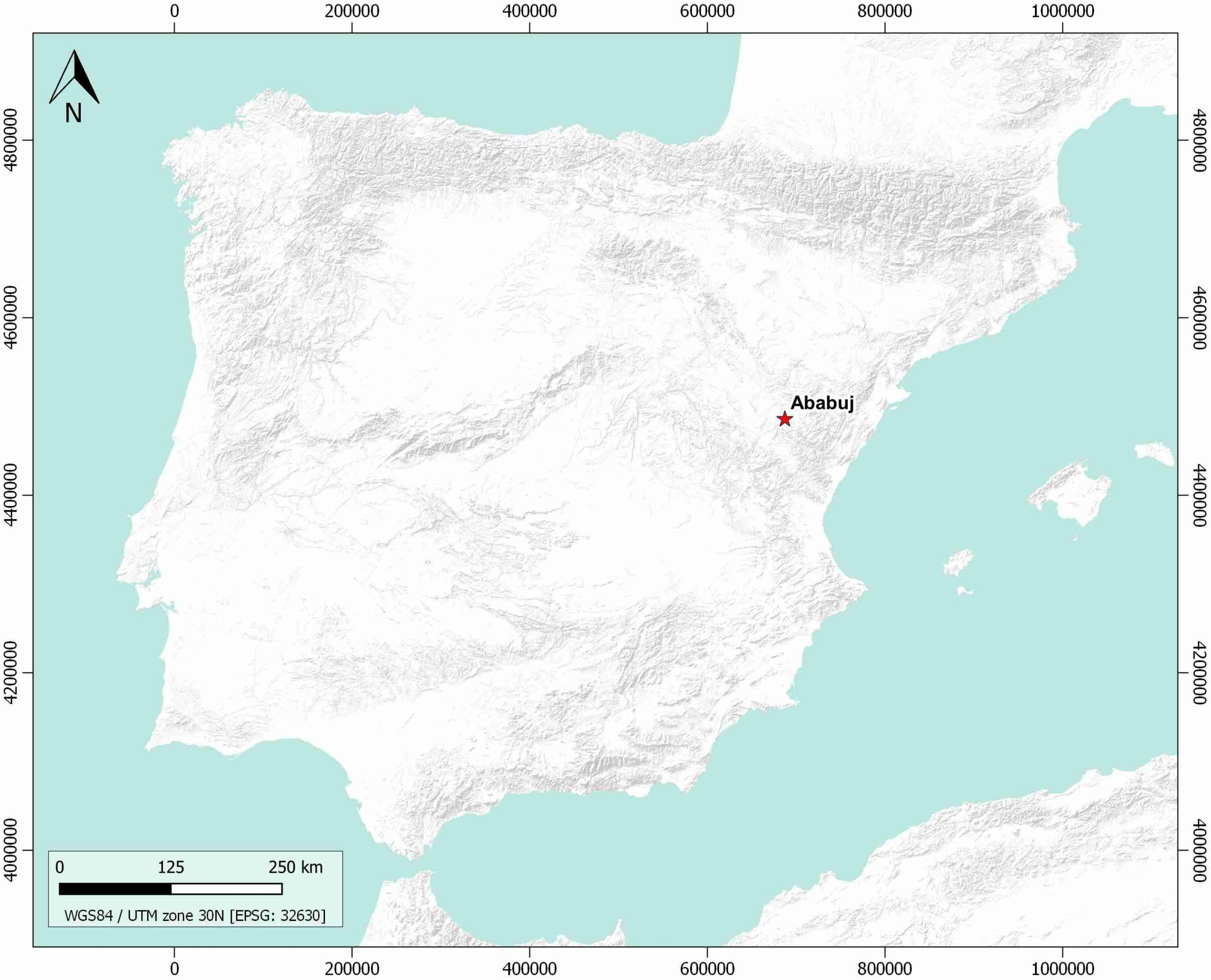
| Name | Ababuj |
| Structure type | Evaporite-cored anticline |
| Deformed/Undeformed | Deformed |
| Buried/Outcropping | Buried |
| Geological setting | Iberian Range |
| Geological Regional Setting | Maestrat Basin |
| Evaporite unit/s name | Keuper facies |
| Evaporite unit/s age | Carnian-Rhaetian (Upper Triassic) |
| Evaporite unit/s era | Mesozoic |
| Evaporite unit/s origin | Marine |
| Evaporite unit/s composition | Shale-Gypsum-Anhydrite |
| Post-kinematic unit/s (or post-evaporite units when evaporites are undeformed) | Quaternary (alluvial and colluvial detrital deposits) |
| Post-kinematic unit/s age (or post-evaporite units when evaporites are undeformed) | Pleistocene-Holocene |
| Classification (Hudec and Jackson, 2009) | Passive piercement |
| Classification (Jackson and Talbot, 1986) | Salt anticline |
| Mining activity? | N |
| Mining activity start | |
| Mining activity end | |
| Mining galleries? | |
| Mining products | |
| Mining sub-products | |
| Evaporite flow? | Y |
| Age of evaporite flow | Jurassic (early salt mobilization) ; Upper Valanginian-Upper Albian (main stage) ; Late Campanian-Early Oligocene (rejuvenation stage) ; Miocene (rejuvenation stage) |
| Flow or deformation triggering mechanisms | Late Jurassic-Early Cretaceous rift and Alpine inversion of listric normal faults |
| Flow-linked structures? | Y |
| Halokinetic structures | Thickness variations / progressive unconformities |
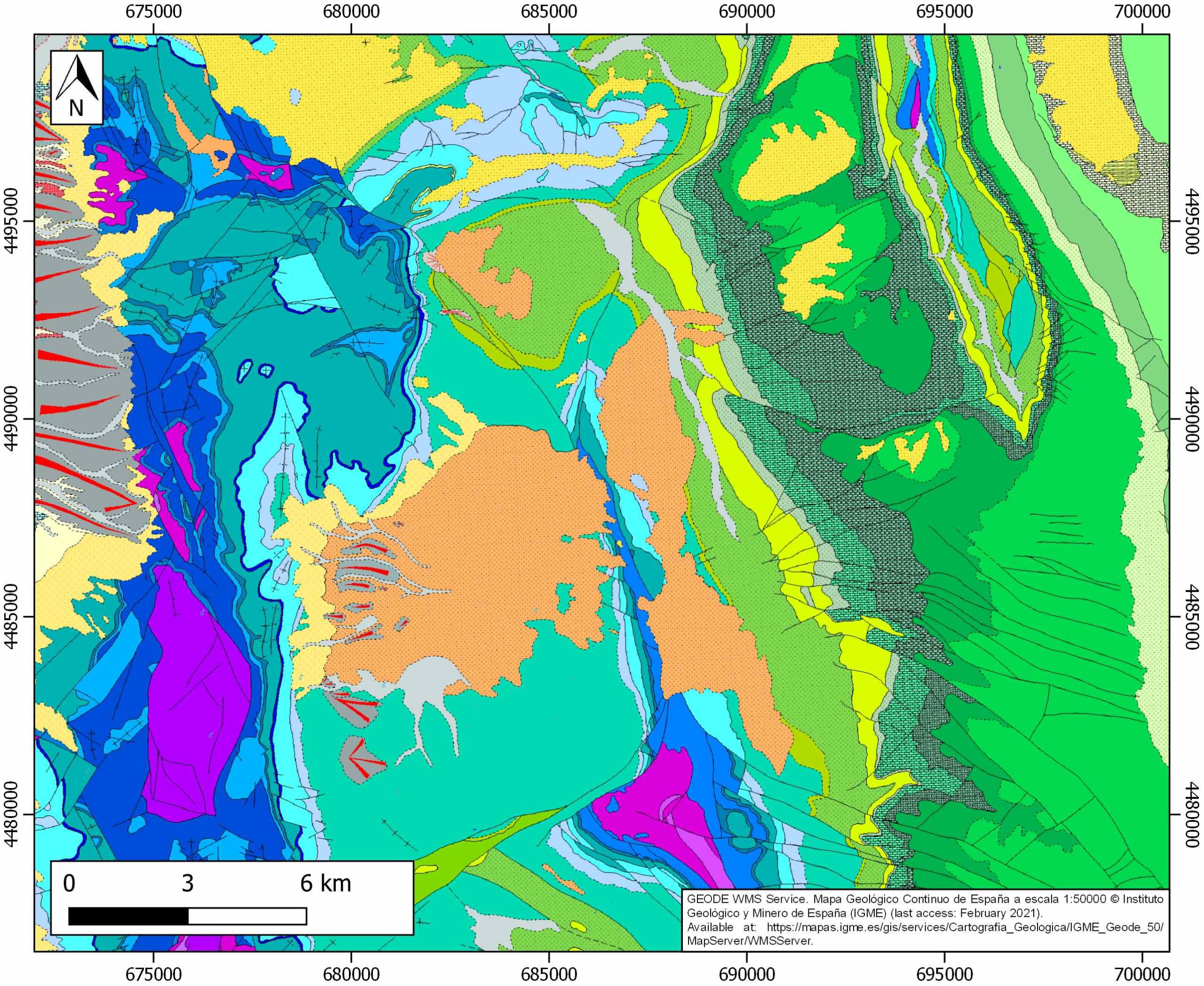
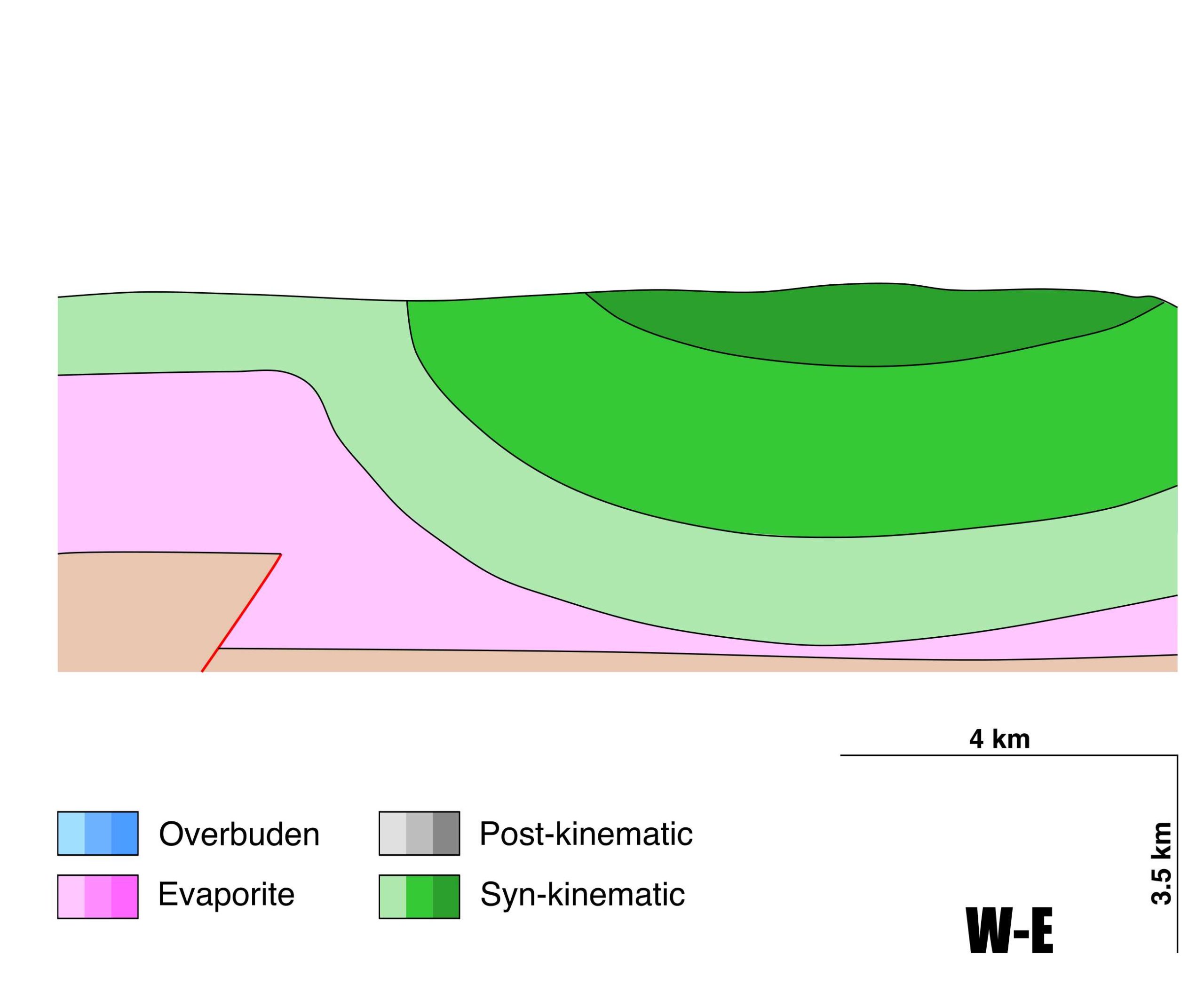
| Post-evaporite and pre-kinematic unit/s (overbuden) | Late Cretaceous (Mosqueruela, Barranco de los Degollados, La Cañadilla and Fortanete Fms., limestones, dolostones and marlstones) |
| Syn-kinematic unit/s | Early Jurassic (Cortes de Tajuña and Cuevas Labradas Fm., limestones and dolostones) ; Late Jurassic (Loriguilla, Higueruelas and Arzobispo Fms., limestones and sandy limestones) ; Hauterivian (El Castellar Fm., limestones and sandstones) ; Barremian (Camarillas, Artoles, Morella and Xert Fms., clays, sandstones, marlstones, limestones) ; Early Aptian (Forcall and Villaroya de los Pinares Fms., marlstones, limestones and nodular limestones) ; Late Aptian (Benassal Fm., marlstone, limestone, nodular limestone) Albian (Escucha and Utrillas Fms., sandstones and claystones) ; Paleogene-Miocene (conglomerates and sandstones) |
| Available seismic profiles | ILIHA C-F |
| Available boreholes | |
| Additional comments | Most active diapiric growth in the Maestrat basin match with eastward drift of the Iberian microplate |
Mining Data
| UNIQUE_ID | 145 |
| Minning exploitations within <2km? | N |
| Historical/Active | |
| Exploitation name #1 | |
| Exploitation ID (Spanish National Mining Cadastre) #1 | |
| Municipality #1 | |
| Province #1 | |
| Company #1 | |
| Main minning Products #1 | |
| Exploitation name #2 | |
| Exploitation ID (Spanish National Mining Cadastre) #2 | |
| Municipality #2 | |
| Province #2 | |
| Company #2 | |
| Main minning Products #2 | |
| Exploitation name #3 | |
| Exploitation ID (Spanish National Mining Cadastre) #3 | |
| Municipality #3 | |
| Province #3 | |
| Company #3 | |
| Main minning Products #3 |
Quantitative Data
| UNIQUE_ID | 145 |
| Outcropping area (km2) | Buried |
| Horizontal intersection area (km2) (when buried) | 10.84226 |
| Depth of intersection area (km2) (when buried) | 0.3 |
| Max. Width (Km) | 9.5 |
| Max. Length (Km) | 2 |
| Max. Evaporites thickness (km) | 1.2 |
| Max. Deformation age (Ma) | 201 |
| Min. Deformation age (Ma) | 5 |
| Deformation stages | 4 |
Reference Data
| UNIQUE_ID | 145 |
| Section source | Vergés, J., Poprawski, Y., Almar, Y., Drzewiecki, P. A., Moragas, M., Bover‐Arnal, T., …, Hunt, D., 2020. Tectono‐Sedimentary Evolution of Jurassic‐Cretaceous diapiric structures: Miravete anticline, Maestrat Basin, Spain. Basin Research, 1-55. [link] |
| Well / Borehole availability #1 | n.a. |
| Well / Borehole availability #2 | n.a. |
| Available data (Stratigraphy) #1 | Aurell, M., Bádenas, B., Gasca, J. M., Canudo, J. I., Liesa, C. L., Soria, A. R., …, Najes, L., 2016. Stratigraphy and evolution of the Galve sub-basin (Spain) in the middle Tithonian–early Barremian: implications for the setting and age of some dinosaur fossil sites. Cretaceous Research, 65, 138-162. [link] |
| Available data (Stratigraphy) #2 | Vergés, J., Poprawski, Y., Almar, Y., Drzewiecki, P. A., Moragas, M., Bover‐Arnal, T., …, Hunt, D., 2020. Tectono‐Sedimentary Evolution of Jurassic‐Cretaceous diapiric structures: Miravete anticline, Maestrat Basin, Spain. Basin Research, 1-55. [link] |
| Available data (Stratigraphy) #3 | Embry, J. C., Vennin, E., Van Buchem, F. S. P., Schroeder, R., Pierre, C., Aurell, M., 2010. Sequence stratigraphy and carbon isotope stratigraphy of an Aptian mixed carbonate-siliciclastic platform to basin transition (Galve sub-basin, NE Spain). Geological Society, London, Special Publications, 329(1), 113-143. [link] |
| Available data (Stratigraphy) #4 | Bover-Arnal, T., Moreno-Bedmar, J. A., Frijia, G., Pascual-Cebrian, E., Salas, R., 2016. Chronostratigraphy of the Barremian–Early Albian of the Maestrat Basin (E Iberian Peninsula): integrating strontium-isotope stratigraphy and ammonoid biostratigraphy. Newsletters on Stratigraphy, 49(1), 41-68. [link] |
| Available data (Stratigraphy) #5 | Navarrete, R., Rodríguez-López, J. P., Liesa, C. L., Soria, A. R., Fernanda de Mesquita, L. V., 2013. Changing physiography of rift basins as a control on the evolution of mixed siliciclastic–carbonate back-barrier systems (Barremian Iberian Basin, Spain). Sedimentary Geology, 289, 40-61. [link] |
| Available data (Stratigraphy) #6 | Meléndez, N., Liesa, C. L., Soria, A. R., Meléndez, A., 2009. Lacustrine system evolution during early rifting: el Castellar formation (Galve sub-basin, Central Iberian Chain). Sedimentary Geology, 222(1-2), 64-77. [link] |
| Regional Stratigraphy | Vergés, J., Poprawski, Y., Almar, Y., Drzewiecki, P. A., Moragas, M., Bover‐Arnal, T., …, Hunt, D., 2020. Tectono‐Sedimentary Evolution of Jurassic‐Cretaceous diapiric structures: Miravete anticline, Maestrat Basin, Spain. Basin Research, 1-55. [link] |
| Seismic data availability #1 | Diaz, J., Gallart Muset, J., Córdoba, D., Senos, L., Matias, L., Suriñach, E., …, Maguire, P., 2020. The ILIHA deep seismic sounding experiment (Iberian LIthosphere Heterogeneity and Anisotropy). DigitalCSIC – SEISDARE data repository. [link] |
| Seismic data availability #2 | n.a. |
| Seismic data availability #3 | n.a. |
| Available data (Structure) #1 | Vergés, J., Poprawski, Y., Almar, Y., Drzewiecki, P. A., Moragas, M., Bover‐Arnal, T., …, Hunt, D., 2020. Tectono‐Sedimentary Evolution of Jurassic‐Cretaceous diapiric structures: Miravete anticline, Maestrat Basin, Spain. Basin Research, 1-55. [link] |
| Available data (Structure) #2 | Salas, R., Guimerà, J., Mas, R., Martin-closas, C., Meléndez, A., Alonso, A., 2001. Evolution of the Mesozoic Central Iberian Rift System and its Cainozoic inversion (Iberian chain). In P. A. Ziegler, W. Cavazza, A. H. F. Robertson, & S. Crasquin-Soleau (Eds), Peritethys memoir 6: Peri-tethyan riftiwrench basins and passive margins. Mem. M, 186, 145–185. [link] |
| Available data (Structure) #3 | Liesa, C. L., Casas, A. M., Simón, J. L., 2018. La tectónica de inversión en una región intraplaca: La Cordillera Ibérica. Revista de la Sociedad Geológica de España, 31(2), 23-50. [link] |
| Available data (Structure) #4 | Liesa, C. L., Soria, A. R., Meléndez, N., Meléndez, A., 2006. Extensional fault control on the sedimentation patterns in a continental rift basin: El Castellar Formation, Galve sub-basin, Spain. Journal of the Geological Society, 163(3), 487-498. [link] |
| Available data (Structure) #5 | Liesa, C. L., Casas, A. M., Simón, J. L., 2018. La tectónica de inversión en una región intraplaca: La Cordillera Ibérica. Revista de la Sociedad Geológica de España, 31(2), 23-50. [link] |
| Available data (Structure) #6 | Simón, J. L., Liesa, C. L., 2011. Incremental slip history of a thrust: diverse transport directions and internal folding of the Utrillas thrust sheet (NE Iberian Chain, Spain). Geological Society, London, Special Publications, 349(1), 77-97. [link] |
| Available data (Analogue modelling) #1 | n.a. |
| Available data (Analogue modelling) #2 | n.a. |
| Available data (Analogue modelling) #3 | n.a. |
| Available data (Gravimetry – Tomography) #1 | Ayala, C., Bohoyo, F., Maestro, A., Reguera, M. I., Torne, M., Rubio, F., Fernández, M., García-Lobón, J. L., 2016. Updated Bouguer anomalies of the Iberian Peninsula: a new perspective to interpret the regional geology. Journal of Maps, 12(5), 1089-1092. [link] |
| Available data (Gravimetry – Tomography) #2 | n.a. |
| Available data (Gravimetry – Tomography) #3 | n.a. |
| Available data (Geochemistry) #1 | n.a. |
| Available data (Geochemistry) #2 | n.a. |
| Available data (Geochemistry) #3 | n.a. |
| Available data (Geochemistry) #4 | n.a. |
| Available data (Petrophysics) #1 | n.a. |
| Available data (Petrophysics) #2 | n.a. |
| IGME Geological Map (MAGNA50) Sheet number | 543-Villarluengo. [link] |
| Other Maps #1 (source) | Vergés, J., Poprawski, Y., Almar, Y., Drzewiecki, P. A., Moragas, M., Bover‐Arnal, T., …, Hunt, D., 2020. Tectono‐Sedimentary Evolution of Jurassic‐Cretaceous diapiric structures: Miravete anticline, Maestrat Basin, Spain. Basin Research, 1-55. [link] |
| Other Maps #2 (source) | Simón-Porcar, G., Liesa, C. L., Simón, J. L., 2018. El ancestro mioceno del alto Alfambra: persistencia de un drenaje SN en la depresión de El Pobo (Teruel, Cordillera Ibérica). Geogaceta, 64, 111-114. [link] |
| Other related references #1 | Navarrete, R., Liesa, C. L., Castanera, D., Soria, A. R., Rodríguez-López, J. P., Canudo, J. I., 2014. A thick Tethyan multi-bed tsunami deposit preserving a dinosaur megatracksite within a coastal lagoon (Barremian, eastern Spain). Sedimentary Geology, 313, 105-127. [link] |
| Other related references #2 | Peropadre, C., Liesa, C. L., Meléndez, N., 2013. High-frequency, moderate to high-amplitude sea-level oscillations during the late Early Aptian: Insights into the Mid-Aptian event (Galve sub-basin, Spain). Sedimentary Geology, 294, 233-250. [link] |
| Other related references #3 | Salas, R., Guimerà, J., 1996. Rasgos estructurales principales de la cuenca cretácica inferior del Maestrazgo (Cordillera Ibérica oriental). Geogaceta, 20(7), 1704-1706. [link] |
| Other related references #4 | n.a. |
Well and Seismic Data
| UNIQUE_ID | 145 |
| Seismic survey name #1 | ILIHA C-F |
| Across structure? #1 | Y |
| Seismic profile ID (IGME) #1 | n.a. |
| Seismic profile code #1 | n.a. |
| Seismic profile name #1 | n.a. |
| Seismic survey year #1 | n.a. |
| Data repository #1 | SeisDARE Database: https://digital.csic.es/handle/10261/101879 |
| Length (km) #1 | 879.18 |
| Seismic survey name #2 | |
| Across structure? #2 | |
| Seismic profile ID (IGME) #2 | |
| Seismic profile code #2 | |
| Seismic profile name #2 | |
| Seismic survey year #2 | |
| Data repository #2 | |
| Length (km) #2 | |
| Seismic survey name #3 | |
| Across structure? #3 | |
| Seismic profile ID (IGME) #3 | |
| Seismic profile code #3 | |
| Seismic profile name #3 | |
| Seismic survey year #3 | |
| Data repository #3 | |
| Length (km) #3 | |
| Seismic survey name #4 | |
| Across structure? #4 | |
| Seismic profile ID (IGME) #4 | |
| Seismic profile code #4 | |
| Seismic profile name #4 | |
| Seismic survey year #4 | |
| Data repository #4 | |
| Length (km) #4 | |
| Seismic survey name #5 | |
| Across structure? #5 | |
| Seismic profile ID (IGME) #5 | |
| Seismic profile code #5 | |
| Seismic profile name #5 | |
| Seismic survey year #5 | |
| Data repository #5 | |
| Length (km) #5 | |
| Seismic survey name #6 | |
| Across structure? #6 | |
| Seismic profile ID (IGME) #6 | |
| Seismic profile code #6 | |
| Seismic profile name #6 | |
| Seismic survey year #6 | |
| Data repository #6 | |
| Length (km) #6 | |
| Seismic survey name #7 | |
| Across structure? #7 | |
| Seismic profile ID (IGME) #7 | |
| Seismic profile code #7 | |
| Seismic profile name #7 | |
| Seismic survey year #7 | |
| Data repository #7 | |
| Length (km) #7 | |
| Seismic survey name #8 | |
| Across structure? #8 | |
| Seismic profile ID (IGME) #8 | |
| Seismic profile code #8 | |
| Seismic profile name #8 | |
| Seismic survey year #8 | |
| Data repository #8 | |
| Length (km) #8 | |
| Seismic survey name #9 | |
| Across structure? #9 | |
| Seismic profile ID (IGME) #9 | |
| Seismic profile code #9 | |
| Seismic profile name #9 | |
| Seismic survey year #9 | |
| Data repository #9 | |
| Length (km) #9 | |
| Seismic survey name #10 | |
| Across structure? #10 | |
| Seismic profile ID (IGME) #10 | |
| Seismic profile code #10 | |
| Seismic profile name #10 | |
| Seismic survey year #10 | |
| Data repository #10 | |
| Length (km) #10 | |
| Seismic survey name #11 | |
| Across structure? #11 | |
| Seismic profile ID (IGME) #11 | |
| Seismic profile code #11 | |
| Seismic profile name #11 | |
| Seismic survey year #11 | |
| Data repository #11 | |
| Length (km) #11 | |
| Seismic survey name #12 | |
| Across structure? #12 | |
| Seismic profile ID (IGME) #12 | |
| Seismic profile code #12 | |
| Seismic profile name #12 | |
| Seismic survey year #12 | |
| Data repository #12 | |
| Length (km) #12 | |
| Seismic survey name #13 | |
| Across structure? #13 | |
| Seismic profile ID (IGME) #13 | |
| Seismic profile code #13 | |
| Seismic profile name #13 | |
| Seismic survey year #13 | |
| Data repository #13 | |
| Length (km) #13 | |
| Seismic survey name #14 | |
| Across structure? #14 | |
| Seismic profile ID (IGME) #14 | |
| Seismic profile code #14 | |
| Seismic profile name #14 | |
| Seismic survey year #14 | |
| Data repository #14 | |
| Length (km) #14 | |
| Seismic survey name #15 | |
| Across structure? #15 | |
| Seismic profile ID (IGME) #15 | |
| Seismic profile code #15 | |
| Seismic profile name #15 | |
| Seismic survey year #15 | |
| Data repository #15 | |
| Length (km) #15 | |
| Seismic survey name #16 | |
| Across structure? #16 | |
| Seismic profile ID (IGME) #16 | |
| Seismic profile code #16 | |
| Seismic profile name #16 | |
| Seismic survey year #16 | |
| Data repository #16 | |
| Length (km) #16 | |
| Seismic survey name #17 | |
| Across structure? #17 | |
| Seismic profile ID (IGME) #17 | |
| Seismic profile code #17 | |
| Seismic profile name #17 | |
| Seismic survey year #17 | |
| Data repository #17 | |
| Length (km) #17 | |
| Seismic survey name #18 | |
| Across structure? #18 | |
| Seismic profile ID (IGME) #18 | |
| Seismic profile code #18 | |
| Seismic profile name #18 | |
| Seismic survey year #18 | |
| Data repository #18 | |
| Length (km) #18 | |
| Seismic survey name #19 | |
| Across structure? #19 | |
| Seismic profile ID (IGME) #19 | |
| Seismic profile code #19 | |
| Seismic profile name #19 | |
| Seismic survey year #19 | |
| Data repository #19 | |
| Length (km) #19 | |
| Seismic survey name #20 | |
| Across structure? #20 | |
| Seismic profile ID (IGME) #20 | |
| Seismic profile code #20 | |
| Seismic profile name #20 | |
| Seismic survey year #20 | |
| Data repository #20 | |
| Length (km) #20 | |
| Seismic survey name #21 | |
| Across structure? #21 | |
| Seismic profile ID (IGME) #21 | |
| Seismic profile code #21 | |
| Seismic profile name #21 | |
| Seismic survey year #21 | |
| Data repository #21 | |
| Length (km) #21 | |
| Borehole name #1 | |
| Company #1 | |
| Traget #1 | |
| Across structure? #1 | |
| Borehole name #2 | |
| Company #2 | |
| Traget #2 | |
| Across structure? #2 | |
| Borehole name #3 | |
| Company #3 | |
| Traget #3 | |
| Across structure? #3 | |
| Borehole name #4 | |
| Company #4 | |
| Traget #4 | |
| Across structure? #4 | |
| Borehole name #5 | |
| Company #5 | |
| Traget #5 | |
| Across structure? #5 | |
| Borehole name #6 | |
| Company #6 | |
| Traget #6 | |
| Across structure? #6 | |
| Borehole name #7 | |
| Company #7 | |
| Traget #7 | |
| Across structure? #7 | |
| Borehole name #8 | |
| Company #8 | |
| Traget #8 | |
| Across structure? #8 | |
| Borehole name #9 | |
| Company #9 | |
| Traget #9 | |
| Across structure? #9 | |
| Borehole name #10 | |
| Company #10 | |
| Traget #10 | |
| Across structure? #10 | |
| Borehole name #11 | |
| Company #11 | |
| Traget #11 | |
| Across structure? #11 | |
| Borehole name #12 | |
| Company #12 | |
| Traget #12 | |
| Across structure? #12 | |
| Borehole name #13 | |
| Company #13 | |
| Traget #13 | |
| Across structure? #13 | |
| Borehole name #14 | |
| Company #14 | |
| Traget #14 | |
| Across structure? #14 | |
| Borehole name #15 | |
| Company #15 | |
| Traget #15 | |
| Across structure? #15 |
Geographical Data (EPSG:4326 - WGS 84)
| UNIQUE_ID | 145 |
| X Centroid (Structure shape) | -0.794068 |
| Y Centroid (Structure shape) | -0.794068 |
| Xmin (Structure shape) | -0.809250 |
| Xmax (Structure shape) | -0.780354 |
| Ymin (Structure shape) | 40.463815 |
| Ymax (Structure shape) | 40.548381 |
| Xmin seismic line #1 | -8.883330 |
| Xmax seismic line #1 | 0.807795 |
| Ymin seismic line #1 | 38.313300 |
| Ymax seismic line #1 | 40.877338 |
| Xmin seismic line #2 | |
| Xmax seismic line #2 | |
| Ymin seismic line #2 | |
| Ymax seismic line #2 | |
| Xmin seismic line #3 | |
| Xmax seismic line #3 | |
| Ymin seismic line #3 | |
| Ymax seismic line #3 | |
| Xmin seismic line #4 | |
| Xmax seismic line #4 | |
| Ymin seismic line #4 | |
| Ymax seismic line #4 | |
| Xmin seismic line #5 | |
| Xmax seismic line #5 | |
| Ymin seismic line #5 | |
| Ymax seismic line #5 | |
| Xmin seismic line #6 | |
| Xmax seismic line #6 | |
| Ymin seismic line #6 | |
| Ymax seismic line #6 | |
| Xmin seismic line #7 | |
| Xmax seismic line #7 | |
| Ymin seismic line #7 | |
| Ymax seismic line #7 | |
| Xmin seismic line #8 | |
| Xmax seismic line #8 | |
| Ymin seismic line #8 | |
| Ymax seismic line #8 | |
| Xmin seismic line #9 | |
| Xmax seismic line #9 | |
| Ymin seismic line #9 | |
| Ymax seismic line #9 | |
| Xmin seismic line #10 | |
| Xmax seismic line #10 | |
| Ymin seismic line #10 | |
| Ymax seismic line #10 | |
| Xmin seismic line #11 | |
| Xmax seismic line #11 | |
| Ymin seismic line #11 | |
| Ymax seismic line #11 | |
| Xmin seismic line #12 | |
| Xmax seismic line #12 | |
| Ymin seismic line #12 | |
| Ymax seismic line #12 | |
| Xmin seismic line #13 | |
| Xmax seismic line #13 | |
| Ymin seismic line #13 | |
| Ymax seismic line #13 | |
| Xmin seismic line #14 | |
| Xmax seismic line #14 | |
| Ymin seismic line #14 | |
| Ymax seismic line #14 | |
| Xmin seismic line #15 | |
| Xmax seismic line #15 | |
| Ymin seismic line #15 | |
| Ymax seismic line #15 | |
| Xmin seismic line #16 | |
| Xmax seismic line #16 | |
| Ymin seismic line #16 | |
| Ymax seismic line #16 | |
| Xmin seismic line #17 | |
| Xmax seismic line #17 | |
| Ymin seismic line #17 | |
| Ymax seismic line #17 | |
| Xmin seismic line #18 | |
| Xmax seismic line #18 | |
| Ymin seismic line #18 | |
| Ymax seismic line #18 | |
| Xmin seismic line #19 | |
| Xmax seismic line #19 | |
| Ymin seismic line #19 | |
| Ymax seismic line #19 | |
| Xmin seismic line #20 | |
| Xmax seismic line #20 | |
| Ymin seismic line #20 | |
| Ymax seismic line #20 | |
| Xmin seismic line #21 | |
| Xmax seismic line #21 | |
| Ymin seismic line #21 | |
| Ymax seismic line #21 | |
| X borehole #1 | |
| Y borehole #1 | |
| X borehole #2 | |
| Y borehole #2 | |
| X borehole #3 | |
| Y borehole #3 | |
| X borehole #4 | |
| Y borehole #4 | |
| X borehole #5 | |
| Y borehole #5 | |
| X borehole #6 | |
| Y borehole #6 | |
| X borehole #7 | |
| Y borehole #7 | |
| X borehole #8 | |
| Y borehole #8 | |
| X borehole #9 | |
| Y borehole #9 | |
| X borehole #10 | |
| Y borehole #10 | |
| X borehole #11 | |
| Y borehole #11 | |
| X borehole #12 | |
| Y borehole #12 | |
| X borehole #13 | |
| Y borehole #13 | |
| X borehole #14 | |
| Y borehole #14 | |
| X borehole #15 | |
| Y borehole #15 |

