General Information
| Structure type | Evaporite Diapir |
| Deformed/Undeformed | Deformed |
| Geological Setting | Algarve Basin, Central Domain |
| Outcropping/buried | Partially buried |
| Evaporite unit/s name | Hettangian Evaporites Unit |
| Evaporite unit/s age | Hettangian (Lower Jurassic) |
| Evaporite unit/s origin | Marine |
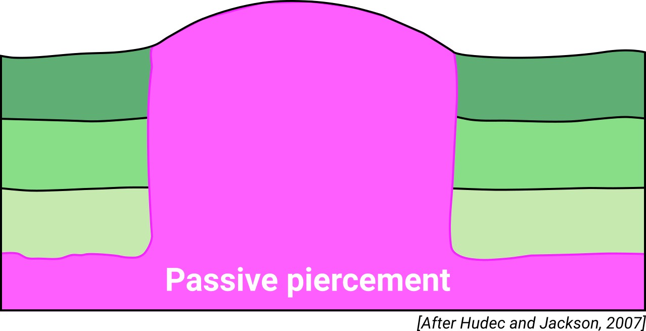
| Classif. (Hudec and Jackson, 2009) | Passive piercement |
| Classif. (Jackson and Talbot, 1986) | Salt wall |
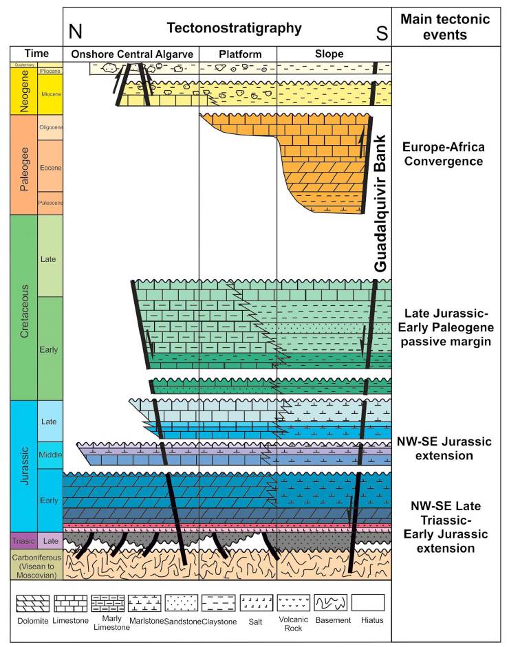
| Age of evaporite flow or deformation (when deformed) | Middle Jurassic to Lower Cretaceous, Oligocene to Miocene |
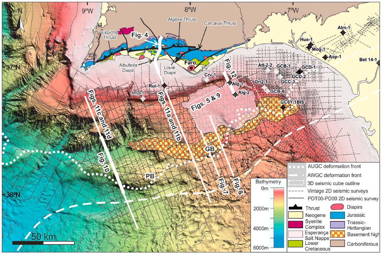
| Other comments | Espiche, Loulé, Albufeira, and Faro diapirs are associated with the main E–W-striking extensional faults. |
Generic Data
| Unique ID | 142 |
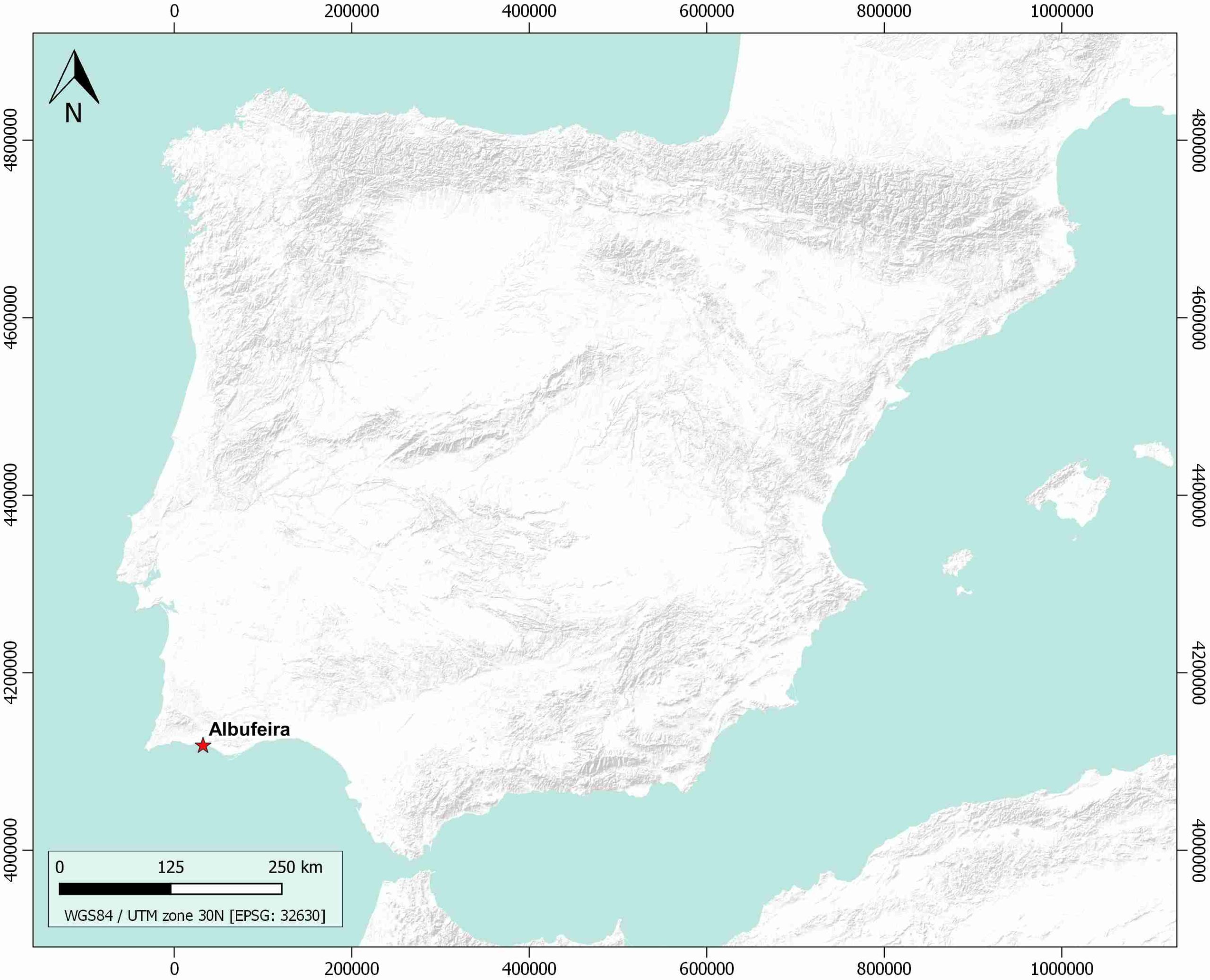
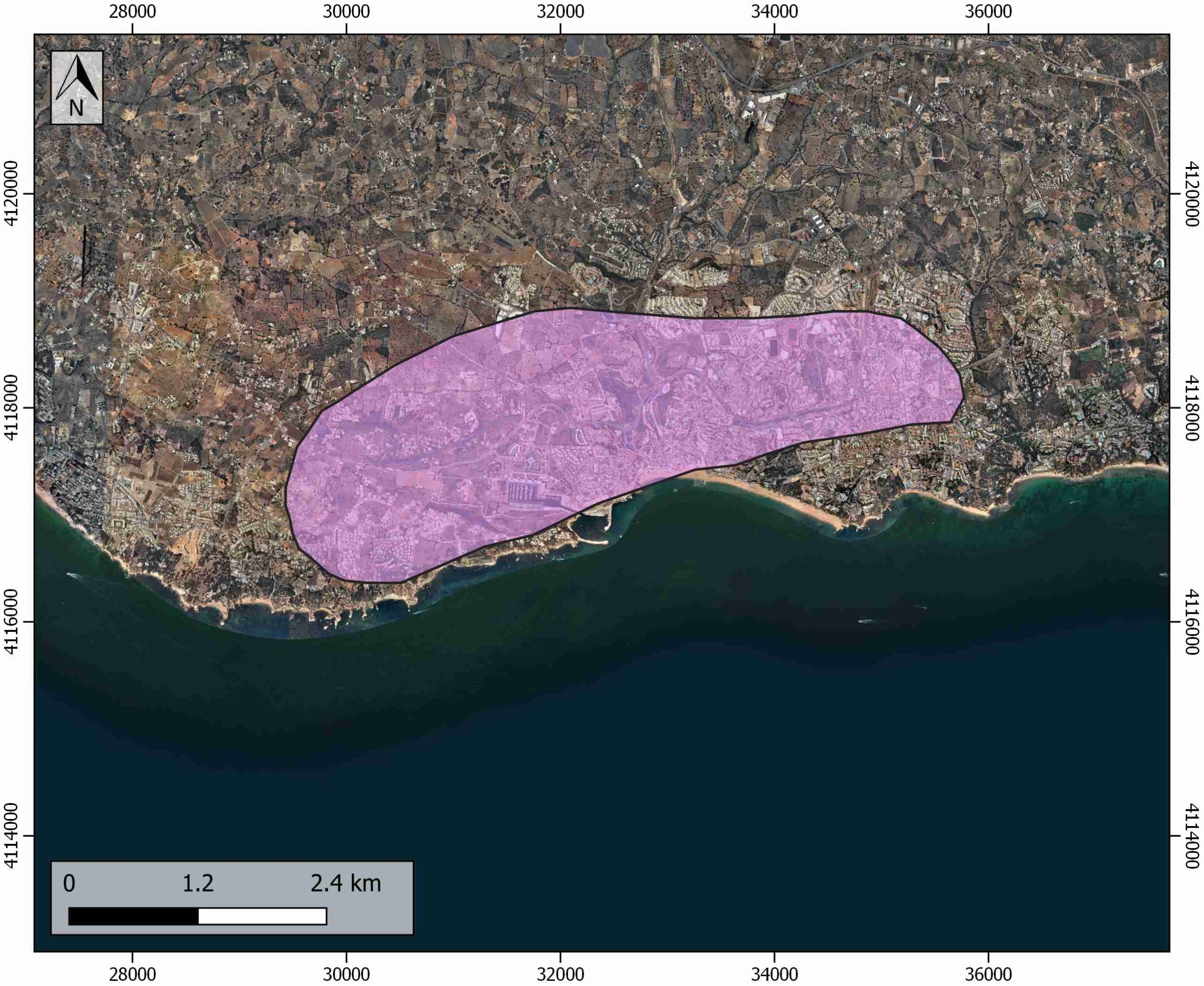
| Name | Albufeira |
| Structure type | Evaporite diapir |
| Deformed/Undeformed | Deformed |
| Buried/Outcropping | Outcropping |
| Geological setting | Algarve basin |
| Geological Regional Setting | Central Domain |
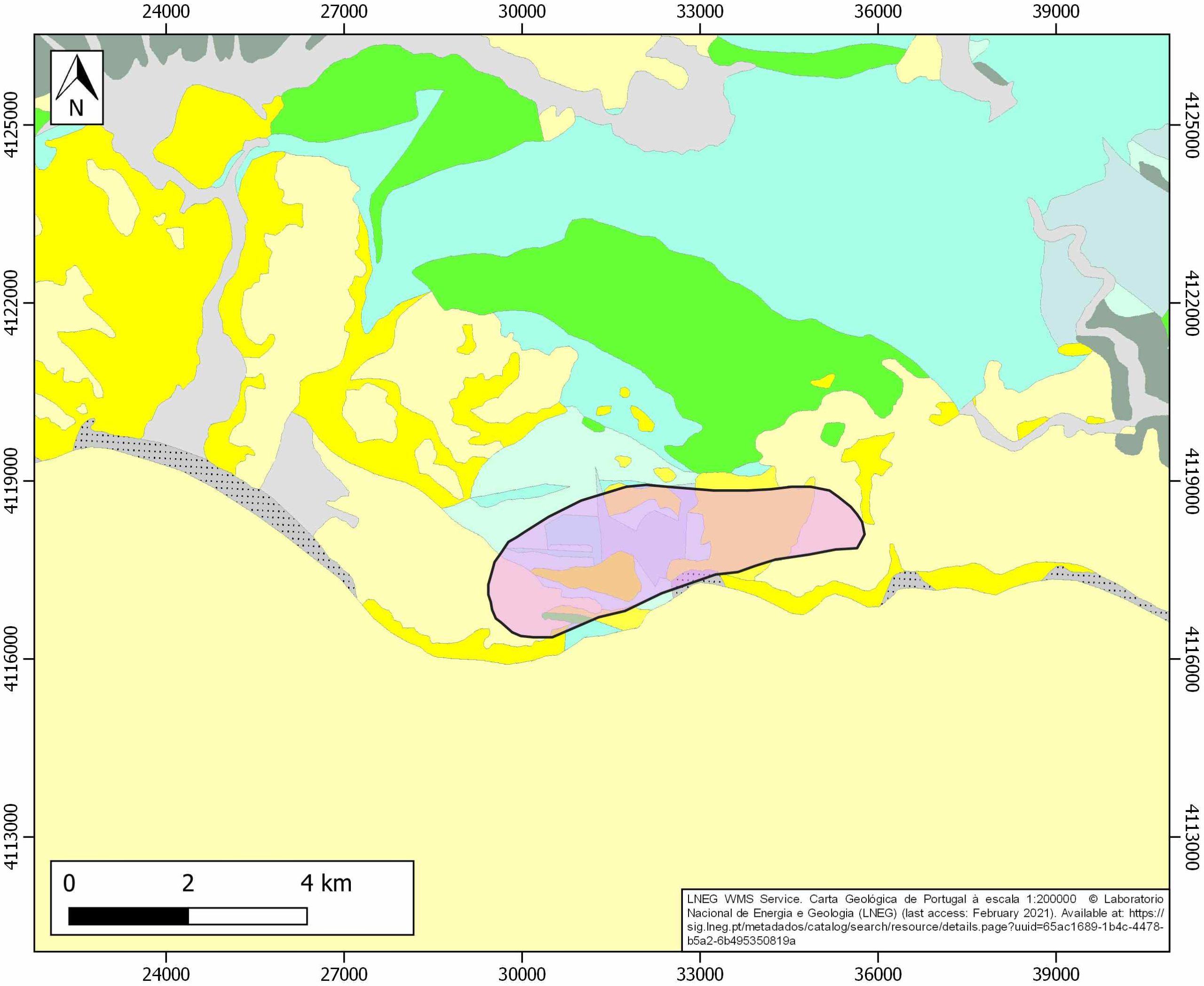
| Evaporite unit/s name | Hettangian Evaporites |
| Evaporite unit/s age | Hettangian (Lower Jurassic) |
| Evaporite unit/s era | Mesozoic |
| Evaporite unit/s origin | Marine |
| Evaporite unit/s composition | Halite |
| Post-kinematic unit/s (or post-evaporite units when evaporites are undeformed) | Pliocene and Quaternary (alluvial and colluvial detrital deposits) |
| Post-kinematic unit/s age (or post-evaporite units when evaporites are undeformed) | Pliocene-Holocene |
| Classification (Hudec and Jackson, 2009) | Passive Piercement |
| Classification (Jackson and Talbot, 1986) | Salt wall |
| Mining activity? | N |
| Mining activity start | |
| Mining activity end | |
| Mining galleries? | |
| Mining products | |
| Mining sub-products | |
| Evaporite flow? | Y |
| Age of evaporite flow | Middle Jurassic-Early Cretaceous and Oligocene-Miocene (reactivation stage) |
| Flow or deformation triggering mechanisms | Extensional regime in the Algarve basin (main stage) Alpine compression (reactivation stage) |
| Flow-linked structures? | Y |
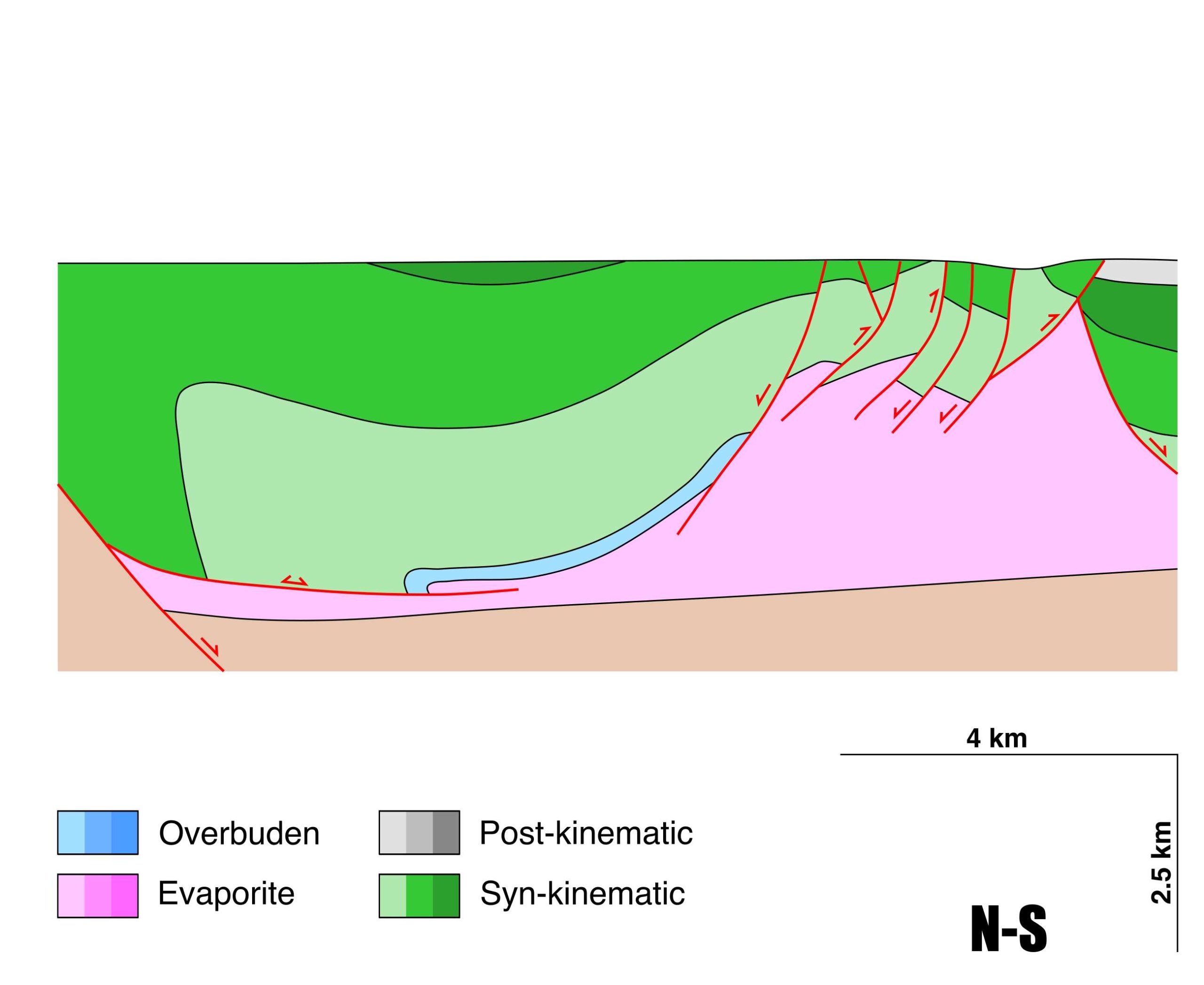
| Halokinetic structures | Syncline-Anticline folding / thrust faults / halite recrystallization veins / progressive unconformities |
| Post-evaporite and pre-kinematic unit/s (overbuden) | Early Jurassic (dolostones and limestones) |
| Syn-kinematic unit/s | Callovian (yellow marls and limestones) ; Oxfordian (limestones and marly limestones intercalation) ; Kimmeridgian (limestones and dolostones) ; Tithonian (limestones) Lower Cretaceous (limestones, marlstones, conglomerates and sandstones) |
| Available seismic profiles | |
| Available boreholes | |
| Additional comments | Espiche, Loulé, Albufeira, and Faro diapirs are associated with the main E–W-striking extensional faults. |
Mining Data
| UNIQUE_ID | 142 |
| Minning exploitations within <2km? | N |
| Historical/Active | |
| Exploitation name #1 | |
| Exploitation ID (Spanish National Mining Cadastre) #1 | |
| Municipality #1 | |
| Province #1 | |
| Company #1 | |
| Main minning Products #1 | |
| Exploitation name #2 | |
| Exploitation ID (Spanish National Mining Cadastre) #2 | |
| Municipality #2 | |
| Province #2 | |
| Company #2 | |
| Main minning Products #2 | |
| Exploitation name #3 | |
| Exploitation ID (Spanish National Mining Cadastre) #3 | |
| Municipality #3 | |
| Province #3 | |
| Company #3 | |
| Main minning Products #3 |
Quantitative Data
| UNIQUE_ID | 142 |
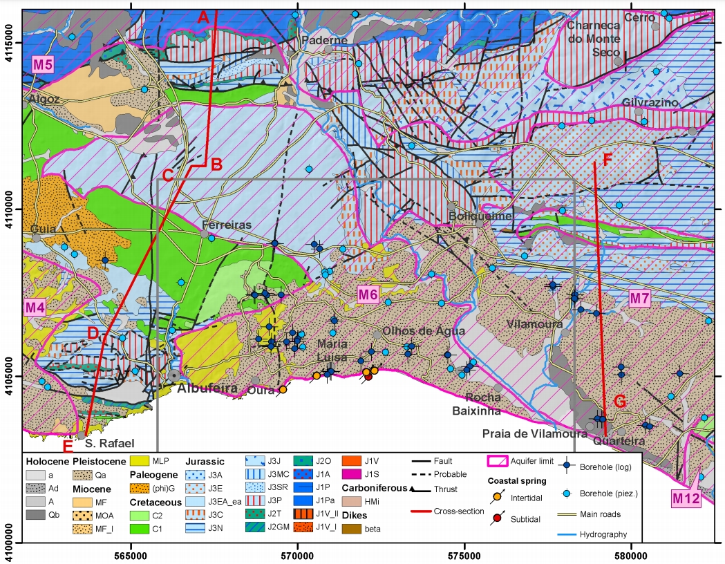
| Outcropping area (km2) | 9.63962 |
| Horizontal intersection area (km2) (when buried) | Not buried |
| Depth of intersection area (km2) (when buried) | Not buried |
| Max. Width (Km) | 2.1 |
| Max. Length (Km) | 6.4 |
| Max. Evaporites thickness (km) | 2.9 |
| Max. Deformation age (Ma) | 166 |
| Min. Deformation age (Ma) | 125 |
| Deformation stages | 2 |
Reference Data
| UNIQUE_ID | 142 |
| Section source | Ramos, A., Fernández, O., Terrinha, P., & Muñoz, J. A., 2016. Extension and inversion structures in the Tethys–Atlantic linkage zone, Algarve Basin, Portugal. International Journal of Earth Sciences, 105(5), 1663-1679. [link] |
| Well / Borehole availability #1 | n.a. |
| Well / Borehole availability #2 | n.a. |
| Available data (Stratigraphy) #1 | Ramos, A., Fernández, O., Terrinha, P., & Muñoz, J. A., 2016. Extension and inversion structures in the Tethys–Atlantic linkage zone, Algarve Basin, Portugal. International Journal of Earth Sciences, 105(5), 1663-1679. [link] |
| Available data (Stratigraphy) #2 | Francés, A., Ramalho, E. C., Fernandes, J., Groen, M., De Plaen, J., Hugman, R., …, Santos, F. A. M., 2014. Hydrogeophysics contribution to the development of hydrogeological conceptual model of coastal aquifers-Albufeira-Ribeira de Quarteira aquifer case study. 8ª Assembleia Luso Espanhola de Geodesia e Geofísica. [link] |
| Available data (Stratigraphy) #3 | Ramos, A., Fernández, O., Muñoz, J. A., Terrinha, P., 2017. Impact of basin structure and evaporite distribution on salt tectonics in the Algarve Basin, Southwest Iberian margin. Marine and Petroleum Geology, 88, 961-984. [link] |
| Available data (Stratigraphy) #4 | Stow, D. A., Faugères, J. C., Gonthier, E., Cremer, M., Llave, E., Hernández-Molina, F. J., …, Diaz-Del-Rio, V., 2002. Faro-Albufeira drift complex, northern Gulf of Cadiz. Geological Society, London, Memoirs, 22(1), 137-154. [link] |
| Available data (Stratigraphy) #5 | Terrinha, P., Rocha, R., Rey, J., Cachão, M., Moura, D., Roque, C., …, Bensalah, M. K., 2006. A Bacia do Algarve: Estratigrafia, paleogeografia e tectónica. Geologia de Portugal no contexto da Ibéria, 1-138. [link] |
| Available data (Stratigraphy) #6 | Ramos, A., Fernández, O., Terrinha, P., & Muñoz, J. A., 2017. Neogene to recent contraction and basin inversion along the Nubia‐Iberia boundary in SW Iberia. Tectonics, 36(2), 257-286. [link] |
| Regional Stratigraphy | Ramos, A., Fernández, O., Terrinha, P., & Muñoz, J. A., 2017. Neogene to recent contraction and basin inversion along the Nubia‐Iberia boundary in SW Iberia. Tectonics, 36(2), 257-286. [link] |
| Seismic data availability #1 | n.a. |
| Seismic data availability #2 | n.a. |
| Seismic data availability #3 | n.a. |
| Available data (Structure) #1 | Ramos, A., Fernández, O., Terrinha, P., & Muñoz, J. A., 2017. Neogene to recent contraction and basin inversion along the Nubia‐Iberia boundary in SW Iberia. Tectonics, 36(2), 257-286. [link] |
| Available data (Structure) #2 | Lopes, F. C., Cunha, P. P., Le Gall, B., 2006. Cenozoic seismic stratigraphy and tectonic evolution of the Algarve margin (offshore Portugal, southwestern Iberian Peninsula). Marine Geology, 231(1-4), 1-36. [link] |
| Available data (Structure) #3 | Ramos, A., Fernández, O., Muñoz, J. A., Terrinha, P., 2017. Impact of basin structure and evaporite distribution on salt tectonics in the Algarve Basin, Southwest Iberian margin. Marine and Petroleum Geology, 88, 961-984. [link] |
| Available data (Structure) #4 | Llave, E., Hernández-Molina, F. J., Somoza, L., Díaz-del-Río, V., Stow, D. A. V., Maestro, A., Dias, J. A., 2001. Seismic stacking pattern of the Faro-Albufeira contourite system (Gulf of Cadiz): a Quaternary record of paleoceanographic and tectonic influences. Marine Geophysical Researches, 22(5), 487-508. [link] |
| Available data (Structure) #5 | Kullberg, J. C., Pais, J., Manuppella, G., 2009. Aspectos gerais da tectónica alpina no Algarve. Ciências da Terra/Earth Sciences Journal, 11. [link] |
| Available data (Structure) #6 | Matias, H., Kress, P., Terrinha, P., Mohriak, W., Menezes, P. T., Matias, L., Santos, F., Sandnes, F., 2011. Salt tectonics in the western Gulf of Cadiz, southwest Iberia. AAPG bulletin, 95(10), 1667-1698. [link] |
| Available data (Analogue modelling) #1 | n.a. |
| Available data (Analogue modelling) #2 | n.a. |
| Available data (Analogue modelling) #3 | n.a. |
| Available data (Gravimetry – Tomography) #1 | Francés, A., Ramalho, E. C., Fernandes, J., Groen, M., De Plaen, J., Hugman, R., …, Santos, F. A. M., 2014. Hydrogeophysics contribution to the development of hydrogeological conceptual model of coastal aquifers-Albufeira-Ribeira de Quarteira aquifer case study. 8ª Assembleia Luso Espanhola de Geodesia e Geofísica. [link] |
| Available data (Gravimetry – Tomography) #2 | Ayala, C., Bohoyo, F., Maestro, A., Reguera, M. I., Torne, M., Rubio, F., Fernández, M., García-Lobón, J. L., 2016. Updated Bouguer anomalies of the Iberian Peninsula: a new perspective to interpret the regional geology. Journal of Maps, 12(5), 1089-1092. [link] |
| Available data (Gravimetry – Tomography) #3 | n.a. |
| Available data (Geochemistry) #1 | n.a. |
| Available data (Geochemistry) #2 | n.a. |
| Available data (Geochemistry) #3 | n.a. |
| Available data (Geochemistry) #4 | n.a. |
| Available data (Petrophysics) #1 | n.a. |
| Available data (Petrophysics) #2 | n.a. |
| IGME Geological Map (MAGNA50) Sheet number | n.a. |
| Other Maps #1 (source) | Ramos, A., Fernández, O., Terrinha, P., & Muñoz, J. A., 2017. Neogene to recent contraction and basin inversion along the Nubia‐Iberia boundary in SW Iberia. Tectonics, 36(2), 257-286. [link] |
| Other Maps #2 (source) | Francés, A., Ramalho, E. C., Fernandes, J., Groen, M., De Plaen, J., Hugman, R., …, Santos, F. A. M., 2014. Hydrogeophysics contribution to the development of hydrogeological conceptual model of coastal aquifers-Albufeira-Ribeira de Quarteira aquifer case study. 8ª Assembleia Luso Espanhola de Geodesia e Geofísica. [link] |
| Other related references #1 | García, M., Llave, E., Hernandez-Molina, F. J., Lobo, F. J., Ercilla, G., Alonso, B., …, Fernandez-Salas, L. M., 2020. The role of late Quaternary tectonic activity and sea-level changes on sedimentary processes interaction in the Gulf of Cadiz upper and middle continental slope (SW Iberia). Marine and Petroleum Geology, 121, 104595. [link] |
| Other related references #2 | Ribeiro, C., Terrinha, P., Andrade, A., Fonseca, B., Caetano, M., Neres, M., …, Manhita, A, 2017. Non-halide sediments from the Loule diapir salt mine: characterization and environmental significance. In EGU General Assembly Conference Abstracts (p. 17094). [link] |
| Other related references #3 | Terrinha, P., Kullberg, J. C., Neres, M., Alves, T., Ramos, A., Ribeiro, C., …, Fernández, Ó., 2019. Rifting of the southwest and west Iberia continental margins.In: Quesada C., Oliveira J. (eds) The Geology of Iberia: A Geodynamic Approach. Regional Geology Reviews. Springer, Cham. [link] |
| Other related references #4 | n.a. |
Well and Seismic Data
| UNIQUE_ID | 142 |
| Seismic survey name #1 | |
| Across structure? #1 | |
| Seismic profile ID (IGME) #1 | |
| Seismic profile code #1 | |
| Seismic profile name #1 | |
| Seismic survey year #1 | |
| Data repository #1 | |
| Length (km) #1 | |
| Seismic survey name #2 | |
| Across structure? #2 | |
| Seismic profile ID (IGME) #2 | |
| Seismic profile code #2 | |
| Seismic profile name #2 | |
| Seismic survey year #2 | |
| Data repository #2 | |
| Length (km) #2 | |
| Seismic survey name #3 | |
| Across structure? #3 | |
| Seismic profile ID (IGME) #3 | |
| Seismic profile code #3 | |
| Seismic profile name #3 | |
| Seismic survey year #3 | |
| Data repository #3 | |
| Length (km) #3 | |
| Seismic survey name #4 | |
| Across structure? #4 | |
| Seismic profile ID (IGME) #4 | |
| Seismic profile code #4 | |
| Seismic profile name #4 | |
| Seismic survey year #4 | |
| Data repository #4 | |
| Length (km) #4 | |
| Seismic survey name #5 | |
| Across structure? #5 | |
| Seismic profile ID (IGME) #5 | |
| Seismic profile code #5 | |
| Seismic profile name #5 | |
| Seismic survey year #5 | |
| Data repository #5 | |
| Length (km) #5 | |
| Seismic survey name #6 | |
| Across structure? #6 | |
| Seismic profile ID (IGME) #6 | |
| Seismic profile code #6 | |
| Seismic profile name #6 | |
| Seismic survey year #6 | |
| Data repository #6 | |
| Length (km) #6 | |
| Seismic survey name #7 | |
| Across structure? #7 | |
| Seismic profile ID (IGME) #7 | |
| Seismic profile code #7 | |
| Seismic profile name #7 | |
| Seismic survey year #7 | |
| Data repository #7 | |
| Length (km) #7 | |
| Seismic survey name #8 | |
| Across structure? #8 | |
| Seismic profile ID (IGME) #8 | |
| Seismic profile code #8 | |
| Seismic profile name #8 | |
| Seismic survey year #8 | |
| Data repository #8 | |
| Length (km) #8 | |
| Seismic survey name #9 | |
| Across structure? #9 | |
| Seismic profile ID (IGME) #9 | |
| Seismic profile code #9 | |
| Seismic profile name #9 | |
| Seismic survey year #9 | |
| Data repository #9 | |
| Length (km) #9 | |
| Seismic survey name #10 | |
| Across structure? #10 | |
| Seismic profile ID (IGME) #10 | |
| Seismic profile code #10 | |
| Seismic profile name #10 | |
| Seismic survey year #10 | |
| Data repository #10 | |
| Length (km) #10 | |
| Seismic survey name #11 | |
| Across structure? #11 | |
| Seismic profile ID (IGME) #11 | |
| Seismic profile code #11 | |
| Seismic profile name #11 | |
| Seismic survey year #11 | |
| Data repository #11 | |
| Length (km) #11 | |
| Seismic survey name #12 | |
| Across structure? #12 | |
| Seismic profile ID (IGME) #12 | |
| Seismic profile code #12 | |
| Seismic profile name #12 | |
| Seismic survey year #12 | |
| Data repository #12 | |
| Length (km) #12 | |
| Seismic survey name #13 | |
| Across structure? #13 | |
| Seismic profile ID (IGME) #13 | |
| Seismic profile code #13 | |
| Seismic profile name #13 | |
| Seismic survey year #13 | |
| Data repository #13 | |
| Length (km) #13 | |
| Seismic survey name #14 | |
| Across structure? #14 | |
| Seismic profile ID (IGME) #14 | |
| Seismic profile code #14 | |
| Seismic profile name #14 | |
| Seismic survey year #14 | |
| Data repository #14 | |
| Length (km) #14 | |
| Seismic survey name #15 | |
| Across structure? #15 | |
| Seismic profile ID (IGME) #15 | |
| Seismic profile code #15 | |
| Seismic profile name #15 | |
| Seismic survey year #15 | |
| Data repository #15 | |
| Length (km) #15 | |
| Seismic survey name #16 | |
| Across structure? #16 | |
| Seismic profile ID (IGME) #16 | |
| Seismic profile code #16 | |
| Seismic profile name #16 | |
| Seismic survey year #16 | |
| Data repository #16 | |
| Length (km) #16 | |
| Seismic survey name #17 | |
| Across structure? #17 | |
| Seismic profile ID (IGME) #17 | |
| Seismic profile code #17 | |
| Seismic profile name #17 | |
| Seismic survey year #17 | |
| Data repository #17 | |
| Length (km) #17 | |
| Seismic survey name #18 | |
| Across structure? #18 | |
| Seismic profile ID (IGME) #18 | |
| Seismic profile code #18 | |
| Seismic profile name #18 | |
| Seismic survey year #18 | |
| Data repository #18 | |
| Length (km) #18 | |
| Seismic survey name #19 | |
| Across structure? #19 | |
| Seismic profile ID (IGME) #19 | |
| Seismic profile code #19 | |
| Seismic profile name #19 | |
| Seismic survey year #19 | |
| Data repository #19 | |
| Length (km) #19 | |
| Seismic survey name #20 | |
| Across structure? #20 | |
| Seismic profile ID (IGME) #20 | |
| Seismic profile code #20 | |
| Seismic profile name #20 | |
| Seismic survey year #20 | |
| Data repository #20 | |
| Length (km) #20 | |
| Seismic survey name #21 | |
| Across structure? #21 | |
| Seismic profile ID (IGME) #21 | |
| Seismic profile code #21 | |
| Seismic profile name #21 | |
| Seismic survey year #21 | |
| Data repository #21 | |
| Length (km) #21 | |
| Borehole name #1 | |
| Company #1 | |
| Traget #1 | |
| Across structure? #1 | |
| Borehole name #2 | |
| Company #2 | |
| Traget #2 | |
| Across structure? #2 | |
| Borehole name #3 | |
| Company #3 | |
| Traget #3 | |
| Across structure? #3 | |
| Borehole name #4 | |
| Company #4 | |
| Traget #4 | |
| Across structure? #4 | |
| Borehole name #5 | |
| Company #5 | |
| Traget #5 | |
| Across structure? #5 | |
| Borehole name #6 | |
| Company #6 | |
| Traget #6 | |
| Across structure? #6 | |
| Borehole name #7 | |
| Company #7 | |
| Traget #7 | |
| Across structure? #7 | |
| Borehole name #8 | |
| Company #8 | |
| Traget #8 | |
| Across structure? #8 | |
| Borehole name #9 | |
| Company #9 | |
| Traget #9 | |
| Across structure? #9 | |
| Borehole name #10 | |
| Company #10 | |
| Traget #10 | |
| Across structure? #10 | |
| Borehole name #11 | |
| Company #11 | |
| Traget #11 | |
| Across structure? #11 | |
| Borehole name #12 | |
| Company #12 | |
| Traget #12 | |
| Across structure? #12 | |
| Borehole name #13 | |
| Company #13 | |
| Traget #13 | |
| Across structure? #13 | |
| Borehole name #14 | |
| Company #14 | |
| Traget #14 | |
| Across structure? #14 | |
| Borehole name #15 | |
| Company #15 | |
| Traget #15 | |
| Across structure? #15 |
Geographical Data (EPSG:4326 - WGS 84)
| UNIQUE_ID | 142 |
| X Centroid (Structure shape) | -8.261372 |
| Y Centroid (Structure shape) | -8.261372 |
| Xmin (Structure shape) | -8.292433 |
| Xmax (Structure shape) | -8.221880 |
| Ymin (Structure shape) | 37.075822 |
| Ymax (Structure shape) | 37.100927 |
| Xmin seismic line #1 | |
| Xmax seismic line #1 | |
| Ymin seismic line #1 | |
| Ymax seismic line #1 | |
| Xmin seismic line #2 | |
| Xmax seismic line #2 | |
| Ymin seismic line #2 | |
| Ymax seismic line #2 | |
| Xmin seismic line #3 | |
| Xmax seismic line #3 | |
| Ymin seismic line #3 | |
| Ymax seismic line #3 | |
| Xmin seismic line #4 | |
| Xmax seismic line #4 | |
| Ymin seismic line #4 | |
| Ymax seismic line #4 | |
| Xmin seismic line #5 | |
| Xmax seismic line #5 | |
| Ymin seismic line #5 | |
| Ymax seismic line #5 | |
| Xmin seismic line #6 | |
| Xmax seismic line #6 | |
| Ymin seismic line #6 | |
| Ymax seismic line #6 | |
| Xmin seismic line #7 | |
| Xmax seismic line #7 | |
| Ymin seismic line #7 | |
| Ymax seismic line #7 | |
| Xmin seismic line #8 | |
| Xmax seismic line #8 | |
| Ymin seismic line #8 | |
| Ymax seismic line #8 | |
| Xmin seismic line #9 | |
| Xmax seismic line #9 | |
| Ymin seismic line #9 | |
| Ymax seismic line #9 | |
| Xmin seismic line #10 | |
| Xmax seismic line #10 | |
| Ymin seismic line #10 | |
| Ymax seismic line #10 | |
| Xmin seismic line #11 | |
| Xmax seismic line #11 | |
| Ymin seismic line #11 | |
| Ymax seismic line #11 | |
| Xmin seismic line #12 | |
| Xmax seismic line #12 | |
| Ymin seismic line #12 | |
| Ymax seismic line #12 | |
| Xmin seismic line #13 | |
| Xmax seismic line #13 | |
| Ymin seismic line #13 | |
| Ymax seismic line #13 | |
| Xmin seismic line #14 | |
| Xmax seismic line #14 | |
| Ymin seismic line #14 | |
| Ymax seismic line #14 | |
| Xmin seismic line #15 | |
| Xmax seismic line #15 | |
| Ymin seismic line #15 | |
| Ymax seismic line #15 | |
| Xmin seismic line #16 | |
| Xmax seismic line #16 | |
| Ymin seismic line #16 | |
| Ymax seismic line #16 | |
| Xmin seismic line #17 | |
| Xmax seismic line #17 | |
| Ymin seismic line #17 | |
| Ymax seismic line #17 | |
| Xmin seismic line #18 | |
| Xmax seismic line #18 | |
| Ymin seismic line #18 | |
| Ymax seismic line #18 | |
| Xmin seismic line #19 | |
| Xmax seismic line #19 | |
| Ymin seismic line #19 | |
| Ymax seismic line #19 | |
| Xmin seismic line #20 | |
| Xmax seismic line #20 | |
| Ymin seismic line #20 | |
| Ymax seismic line #20 | |
| Xmin seismic line #21 | |
| Xmax seismic line #21 | |
| Ymin seismic line #21 | |
| Ymax seismic line #21 | |
| X borehole #1 | |
| Y borehole #1 | |
| X borehole #2 | |
| Y borehole #2 | |
| X borehole #3 | |
| Y borehole #3 | |
| X borehole #4 | |
| Y borehole #4 | |
| X borehole #5 | |
| Y borehole #5 | |
| X borehole #6 | |
| Y borehole #6 | |
| X borehole #7 | |
| Y borehole #7 | |
| X borehole #8 | |
| Y borehole #8 | |
| X borehole #9 | |
| Y borehole #9 | |
| X borehole #10 | |
| Y borehole #10 | |
| X borehole #11 | |
| Y borehole #11 | |
| X borehole #12 | |
| Y borehole #12 | |
| X borehole #13 | |
| Y borehole #13 | |
| X borehole #14 | |
| Y borehole #14 | |
| X borehole #15 | |
| Y borehole #15 |

