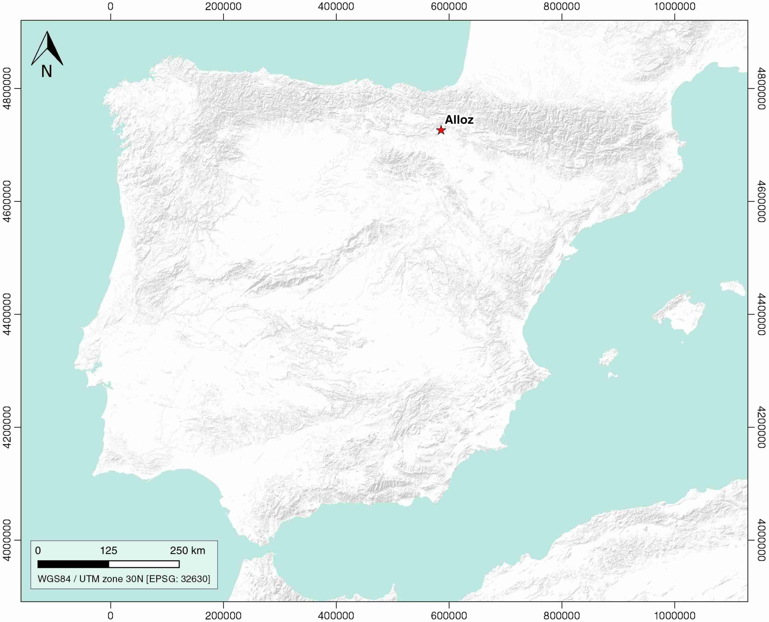
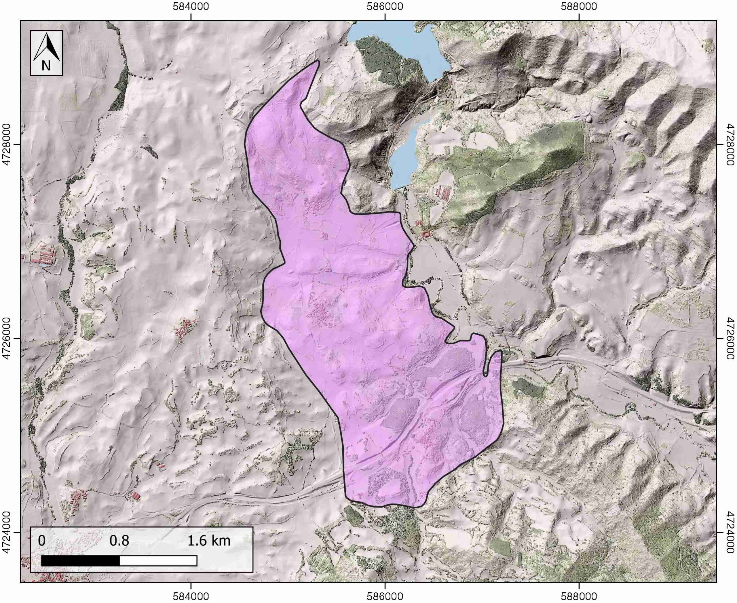
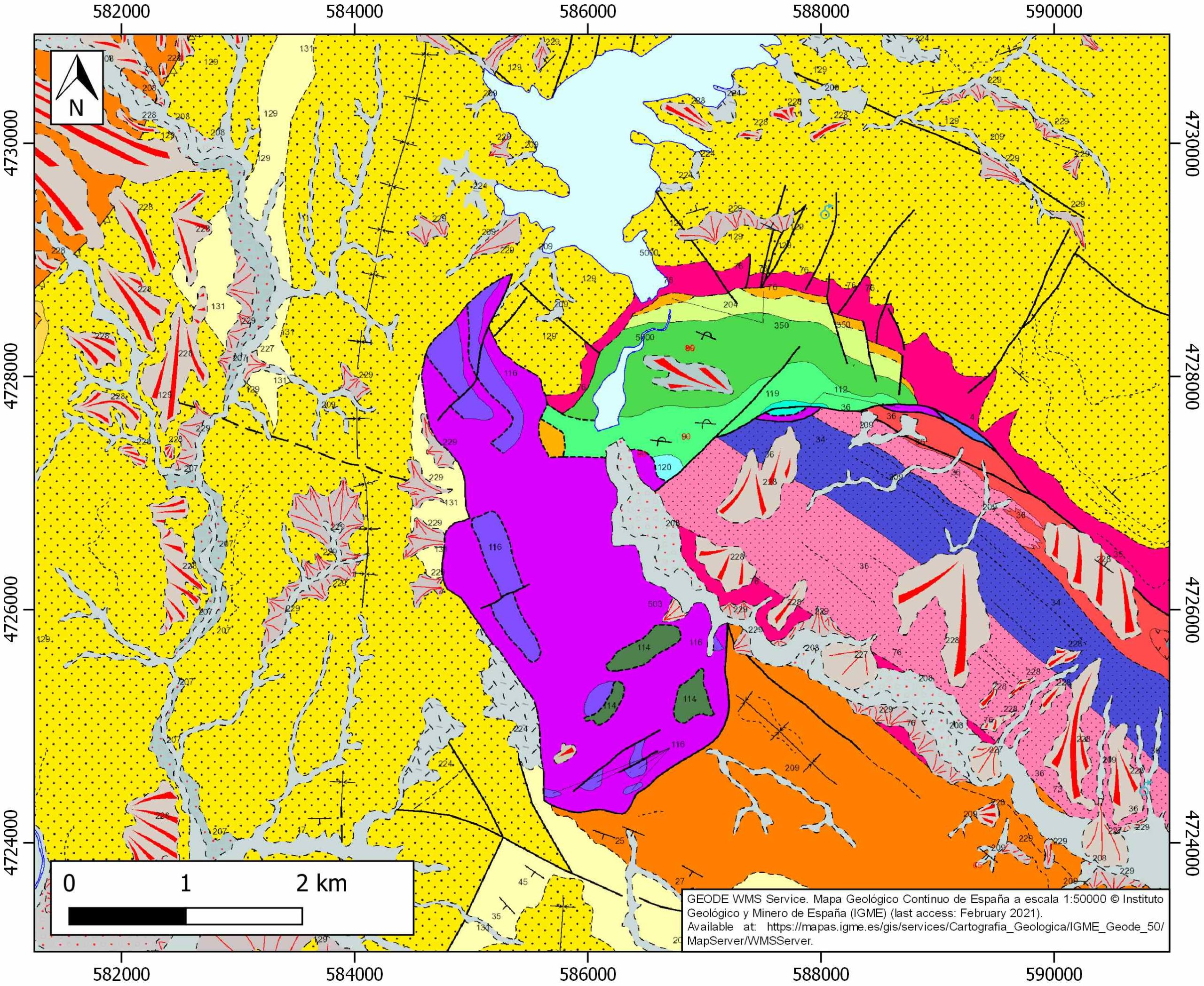
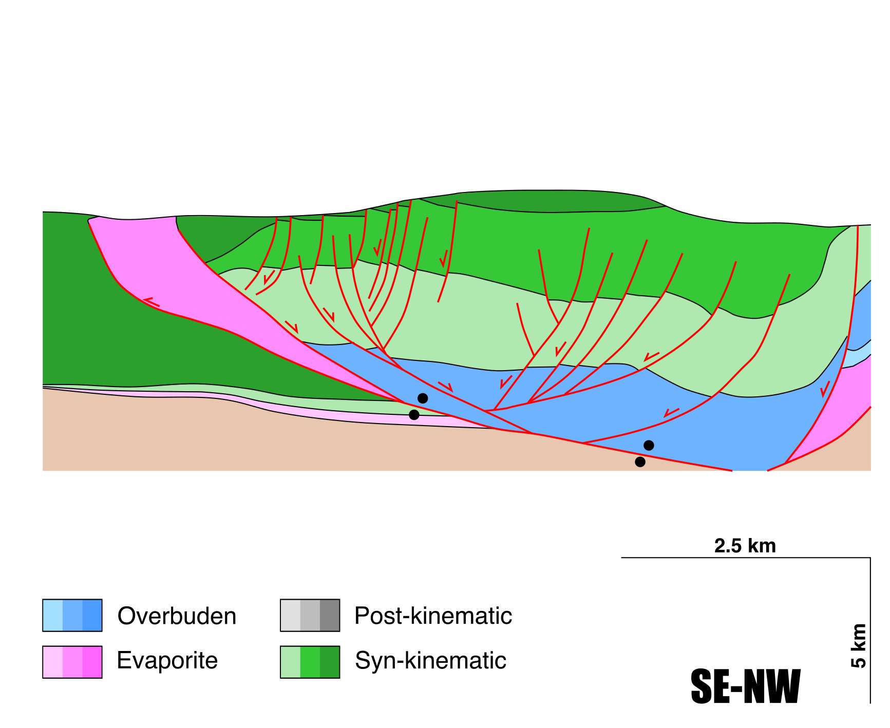
General Information
| Structure type | Evaporite-detached thrust |
| Deformed/Undeformed | Deformed |
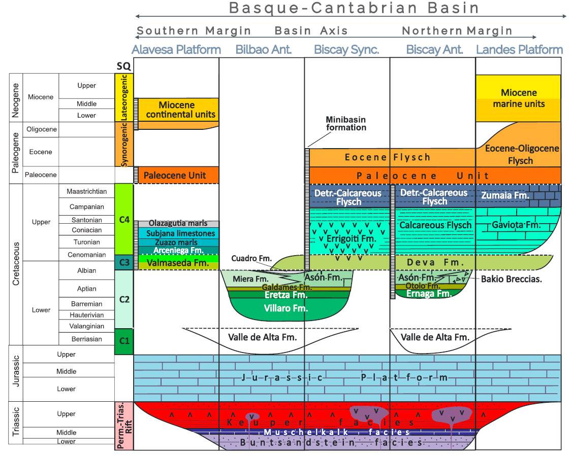
| Geological Setting | Basque-Cantabrian Basin, Navarra-Álava trough |
| Outcropping/buried | Outcropping |
| Evaporite unit/s name | Keuper facies |
| Evaporite unit/s age | Carnian-Rhaetian (Upper Triassic) |
| Evaporite unit/s origin | Marine |
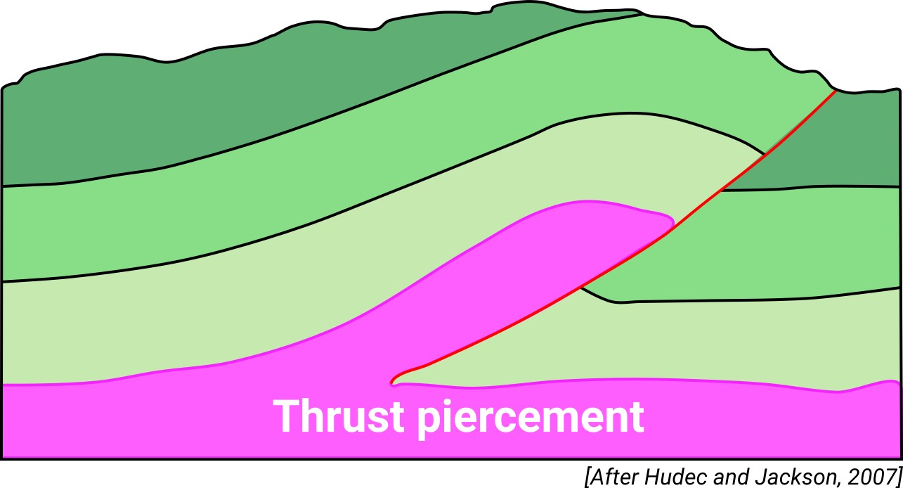
| Classif. (Hudec and Jackson, 2009) | Thrust piercement |
| Classif. (Jackson and Talbot, 1986) | Salt roller, Welded |
| Age of evaporite flow or deformation (when deformed) | Burdigalian to Tortonian, Lower Cretaceous |
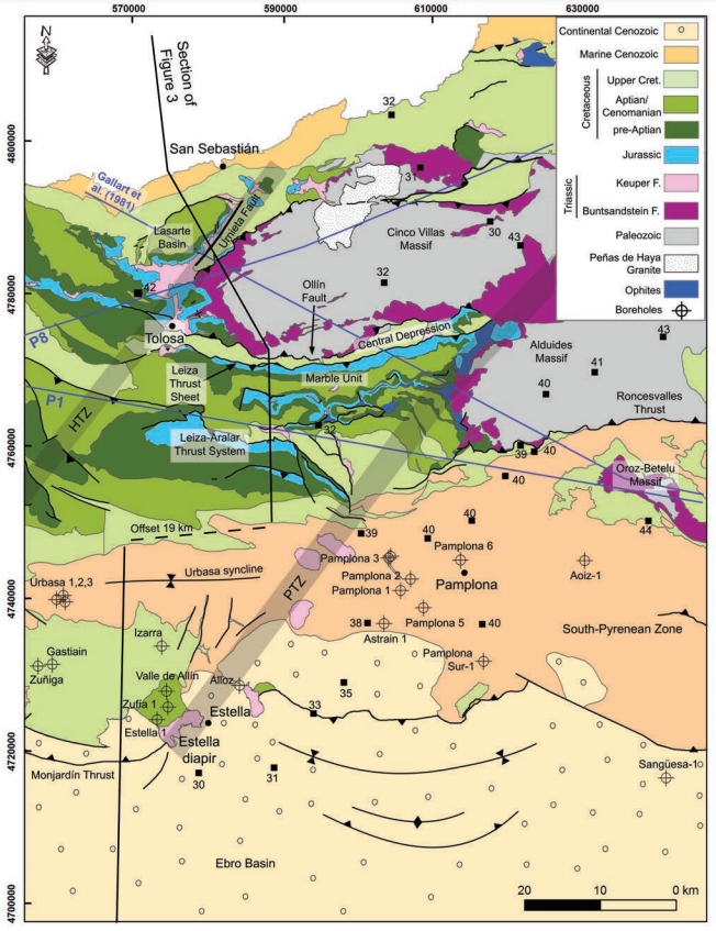
| Other comments | Alignment of the Salinas del Oro, Anoz, Alloz, Estella, Ollo, Echalecu and Iza along the Pamplona fault. Estella and Alloz diapirs are connected by buried salt anticlines in one salt body (see Pinto et al., 2000, 2005). |
Generic Data
| Unique ID | 27 |
| Name | Alloz |
| Structure type | Evaporite-detached thrust |
| Deformed/Undeformed | Deformed |
| Buried/Outcropping | Outcropping |
| Geological setting | Basque-Cantabrian Basin |
| Geological Regional Setting | Navarra-Álava trough |
| Evaporite unit/s name | Keuper facies |
| Evaporite unit/s age | Carnian-Rhaetian (Upper Triassic) |
| Evaporite unit/s era | Mesozoic |
| Evaporite unit/s origin | Marine |
| Evaporite unit/s composition | Gypsum-Halite-Anhydrite-Claystone-Ophites |
| Post-kinematic unit/s (or post-evaporite units when evaporites are undeformed) | Quaternary (alluvial and colluvial detrital deposits) |
| Post-kinematic unit/s age (or post-evaporite units when evaporites are undeformed) | Pleistocene-Holocene |
| Classification (Hudec and Jackson, 2009) | Thrust piercement |
| Classification (Jackson and Talbot, 1986) | Salt roller |
| Mining activity? | Y |
| Mining activity start | Roman Empire |
| Mining activity end | |
| Mining galleries? | |
| Mining products | Halite |
| Mining sub-products | |
| Evaporite flow? | Y |
| Age of evaporite flow | Berriasian – Albian (early stage) and Burdigalian – Tortonian (main stage) |
| Flow or deformation triggering mechanisms | Thrust sheet with a southward motion |
| Flow-linked structures? | Y |
| Halokinetic structures | Progressive unconformities / normal and thrust faults / radial joints / thickness variations |
| Post-evaporite and pre-kinematic unit/s (overbuden) | Jurassic (dolostones, marls and oolitic limestones) |
| Syn-kinematic unit/s | Upper Weald facies (sandstones) / Aptian-middle Albian (Urgonian Group: marlstones, marly limestones, packstones, carbonate brecchias, rudistid limestones; Punta del Bakio Unit: turbidites, mudstones and carbonate grainstones) / Miocene (shales, sandstones and conglomerates) |
| Available seismic profiles | P-15 / P-13 / ALL-9 / P-5 / P-14 / P-18 / ALL-9 / ELZ-9 / ELZ84-06 / P-13 / AN-01 / P-10 / C-40-1 / P-15 / P-12 / C-40 / P-15-1 / P-11 / P-9 / P-5 / P-18 |
| Available boreholes | ALLOZ-1 |
| Additional comments | Alignment of the Salinas del Oro, Anoz, Alloz, Estella, Ollo, Echalecu and Iza along the Pamplona fault. Estella and Alloz diapirs are connected by buried salt anticlines in one salt body (see Pinto et al., 2000, 2005) |
Mining Data
| UNIQUE_ID | 27 |
| Minning exploitations within <2km? | Y |
| Historical/Active | Historical (not indexed in the Spanish National Minning Cadastre) |
| Exploitation name #1 | n.a. |
| Exploitation ID (Spanish National Mining Cadastre) #1 | n.a. |
| Municipality #1 | n.a. |
| Province #1 | n.a. |
| Company #1 | n.a. |
| Main minning Products #1 | Halite |
| Exploitation name #2 | |
| Exploitation ID (Spanish National Mining Cadastre) #2 | |
| Municipality #2 | |
| Province #2 | |
| Company #2 | |
| Main minning Products #2 | |
| Exploitation name #3 | |
| Exploitation ID (Spanish National Mining Cadastre) #3 | |
| Municipality #3 | |
| Province #3 | |
| Company #3 | |
| Main minning Products #3 |
Quantitative Data
| UNIQUE_ID | 27 |
| Outcropping area (km2) | 5.74957 |
| Horizontal intersection area (km2) (when buried) | Not buried |
| Depth of intersection area (km2) (when buried) | Not buried |
| Max. Width (Km) | 4.6 |
| Max. Length (Km) | 2.1 |
| Max. Evaporites thickness (km) | 4 |
| Max. Deformation age (Ma) | 145 |
| Min. Deformation age (Ma) | 16 |
| Deformation stages | 2 |
Reference Data
| UNIQUE_ID | 27 |
| Section source | Cámara, P., 2020. Inverted turtle salt anticlines in the eastern basque-cantabrian basin, Spain. Marine and Petroleum Geology, 104358. [link] |
| Well / Borehole availability #1 | Cámara, P., 2020. Inverted turtle salt anticlines in the eastern basque-cantabrian basin, Spain. Marine and Petroleum Geology, 104358. [link] |
| Well / Borehole availability #2 | n.a. |
| Available data (Stratigraphy) #1 | Cámara, P., 2020. Inverted turtle salt anticlines in the eastern basque-cantabrian basin, Spain. Marine and Petroleum Geology, 104358. [link] |
| Available data (Stratigraphy) #2 | Larrasoaña, J. C., Parés, J. M., Millán, H., Del Valle, J., Pueyo, E. L., 2003. Paleomagnetic, structural, and stratigraphic constraints on transverse fault kinematics during basin inversion: The Pamplona Fault (Pyrenees, north Spain). Tectonics, 22(6), 1-22. [link] |
| Available data (Stratigraphy) #3 | López-Horgue, M. A., Owen, H. G., Rodríguez-Lázaro, J., Fernández-Mendiola, P. A., García-Mondéjar, J., 1999. Late Albian–Early Cenomanian stratigraphic succession near Estella-Lizarra (Navarra, central northern Spain) and its regional and interregional correlation. Cretaceous Research, 20(4), 369-402. [link] |
| Available data (Stratigraphy) #4 | Pflug, R., 1973. El diapiro de Estella. Munibe, Sociedad de Ciencias Naturales Aranzadi (San Sebastian), 25, 171-202. [link] |
| Available data (Stratigraphy) #5 | Riba i Arderiu, O., 1992. Las secuencias oblicuas en el borde Norte de la Depresión del Ebro en Navarra y la Discordancia de Barbarín. Acta geológica hispánica, 55-68. [link] |
| Available data (Stratigraphy) #6 | López-Horgue, M. A., Owen, H. G., Rodríguez-Lázaro, J., Fernández-Mendiola, P. A., García-Mondéjar, J., 1999. Late Albian–Early Cenomanian stratigraphic succession near Estella-Lizarra (Navarra, central northern Spain) and its regional and interregional correlation. Cretaceous Research, 20(4), 369-402. [link] |
| Regional Stratigraphy | Pedrera, A., García‐Senz, J., Ayala, C., Ruiz‐Constán, A., Rodríguez‐Fernández, L. R., Robador, A., González Menéndez, L., 2017. Reconstruction of the exhumed mantle across the North Iberian Margin by crustal‐scale 3‐D gravity inversion and geological cross section. Tectonics, 36, 3155-3177. [link] |
| Seismic data availability #1 | Cámara, P., 2020. Inverted turtle salt anticlines in the eastern basque-cantabrian basin, Spain. Marine and Petroleum Geology, 104358. [link] |
| Seismic data availability #2 | Pedrera, A., García‐Senz, J., Ayala, C., Ruiz‐Constán, A., Rodríguez‐Fernández, L. R., Robador, A., González Menéndez, L., 2017. Reconstruction of the exhumed mantle across the North Iberian Margin by crustal‐scale 3‐D gravity inversion and geological cross section. Tectonics, 36, 3155-3177. [link] |
| Seismic data availability #3 | n.a. |
| Available data (Structure) #1 | Cámara, P., 2020. Inverted turtle salt anticlines in the eastern basque-cantabrian basin, Spain. Marine and Petroleum Geology, 104358. [link] |
| Available data (Structure) #2 | López-Horgue, M. A., Owen, H. G., Rodríguez-Lázaro, J., Fernández-Mendiola, P. A., García-Mondéjar, J., 1999. Late Albian–Early Cenomanian stratigraphic succession near Estella-Lizarra (Navarra, central northern Spain) and its regional and interregional correlation. Cretaceous Research, 20(4), 369-402. [link] |
| Available data (Structure) #3 | Poprawski, Y., Basile, C., 2018. Long-lasting diapir growth history in the Basque-Cantabrian basin (Northern Spain): a review. Conference poster, Advances in Salt Tectonics: Observations, Applications, and Perspective: In Honor of Martin P.A. Jackson. [link] |
| Available data (Structure) #4 | Riba i Arderiu, O., 1992. Las secuencias oblicuas en el borde Norte de la Depresión del Ebro en Navarra y la Discordancia de Barbarín. Acta geológica hispánica, 55-68. [link] |
| Available data (Structure) #5 | Larrasoaña, J. C., Parés, J. M., Millán, H., Del Valle, J., Pueyo, E. L., 2003. Paleomagnetic, structural, and stratigraphic constraints on transverse fault kinematics during basin inversion: The Pamplona Fault (Pyrenees, north Spain). Tectonics, 22(6), 1-22. [link] |
| Available data (Structure) #6 | Pflug, R., 1973. El diapiro de Estella. Munibe, Sociedad de Ciencias Naturales Aranzadi (San Sebastian), 25, 171-202. [link] |
| Available data (Analogue modelling) #1 | n.a. |
| Available data (Analogue modelling) #2 | n.a. |
| Available data (Analogue modelling) #3 | n.a. |
| Available data (Gravimetry – Tomography) #1 | Pinto, V., Rivero, L., Ponsatí, A. C., 2000. Modelo gravimétrico de los diapiros de Estella y Alloz, y localización de nuevos diapiros no aflorantes en la zona sur de Atauri, Cubeta Alavesa. Revista de la Sociedad Geológica de España, 13(3), 529-538. [link] |
| Available data (Gravimetry – Tomography) #2 | Pinto, V., Casas, A., Rivero, L., Torne, M., 2005. 3D gravity modeling of the Triassic salt diapirs of the Cubeta Alavesa (northern Spain). Tectonophysics, 405, 65-75. [link] |
| Available data (Gravimetry – Tomography) #3 | Ayala, C., Bohoyo, F., Maestro, A., Reguera, M. I., Torne, M., Rubio, F., Fernández, M., García-Lobón, J. L., 2016. Updated Bouguer anomalies of the Iberian Peninsula: a new perspective to interpret the regional geology. Journal of Maps, 12(5), 1089-1092. [link] |
| Available data (Geochemistry) #1 | Iribar, V., Ábalos, B. 2011. The geochemical and isotopic record of evaporite recycling in spas and salterns of the Basque Cantabrian basin, Spain. Applied geochemistry, 26, 1315-1329. [link] |
| Available data (Geochemistry) #2 | Ortí, F., García-Veigas, J., Rossell, L., Jurado, M. J., Utrilla, R., 1996. Formaciones salinas de las cuencas triásicas en la Península Ibérica: Caracterización Petrológica y Geoquímica. Cuadernos de Geología Ibérica, 20, 13-35. [link] |
| Available data (Geochemistry) #3 | Béziat, D., Joron, J.L., Monchoux, P., Treuil, M., Walgenwitz, F., 1991. Geodynamic implications of geochemical data for the Pyrenean ophites (Spain-France). Chemical Geology, 89, 243-262. [link] |
| Available data (Geochemistry) #4 | n.a. |
| Available data (Petrophysics) #1 | Llamas, B., Castañeda, M. C., Laín, C., Pous, J., 2017. Study of the Basque–Cantabrian basin as a suitable region for the implementation of an energy storage system based on compressed air energy storage (CAES). Environmental Earth Sciences, 76(5), 204. [link] |
| Available data (Petrophysics) #2 | Soto, R., Beamud, E., Roca, E., Carola, E., Almar, Y., 2017. Distinguishing the effect of diapir growth on magnetic fabrics of syn-diapiric overburden rocks: Basque-Cantabrian basin, Northern Spain. Terra Nova 29, 191-201. [link] |
| IGME Geological Map (MAGNA50) Sheet number | 140-Estella. [link] |
| Other Maps #1 (source) | Perona, J., 2016. Mineralizaciones de Pb-Zn asociadas a los diapiros de Murguía y Orduña (Cuenca Vasco-Cantábrica) [PhD thesis]: Barcelona, Universitat de Barcelona, 281 pp. [link] |
| Other Maps #2 (source) | DeFelipe, I., Álvarez Pulgar, F. J., & Pedreira Rodríguez, D., 2018. Crustal structure of the Eastern Basque-Cantabrian Zone-western Pyrenees: from the Cretaceous hyperextension to the Cenozoic inversion. Revista de la Sociedad Geológica de España, 31 (2), 69-82. [link] |
| Other related references #1 | Ábalos, B., 2016. Geologic map of the Basque-Cantabrian Basin and a new tectonic interpretation of the Basque Arc. International Journal of Earth Sciences, 105, 2327-2354. [link] |
| Other related references #2 | Ruiz, M., Díaz, J., Gallart, J., Pulgar, J.A., González-Cortina, J.M., López, C., 2006. Seismotectonic constraints at the western edge of the Pyrenees: aftershock series monitoring of the 2002 February 21, 4.1 Lg earthquake. Geophysical Journal International, 166, 238–252. [link] |
| Other related references #3 | Ruiz, M., Gallart, J., Díaz, J., Olivera, C., Pedreira, D., López, C., González-Cortina, J.M., Pulgar, J.A., 2006. Seismic activity at the western Pyrenean edge. Tectonophysics, 412, 217–235. [link] |
| Other related references #4 | Rios, J. M., 1948. Mapa Geológico de la Zona Cántabro-Navarra con las chimeneas salinas diapíricas de Salinas de Rosío, Villasana de Mena, Orduña, Murguía, Salinas de Añana, Maestu, Estella, Lácar, Salinas de Oro, Goñi y Atondo (scale 1/300.000, 80 × 34 cm). In: “Diapirismo”. Boletín del Instituto Geológico y Minero de España, 60, pp 153–390. [link] |
Well and Seismic Data
| UNIQUE_ID | 27 |
| Seismic survey name #1 | 8C-ST-182 |
| Across structure? #1 | Y |
| Seismic profile ID (IGME) #1 | 13278 |
| Seismic profile code #1 | 17996 |
| Seismic profile name #1 | P-15 |
| Seismic survey year #1 | 1958 |
| Data repository #1 | SIGEOF Data Catalogue (Private access section). ©Instituto Geológico y Minero de España (IGME). https://info.igme.es/SIGEOF/ |
| Length (km) #1 | 3.00 |
| Seismic survey name #2 | 8C-ST-182 |
| Across structure? #2 | Y |
| Seismic profile ID (IGME) #2 | 13280 |
| Seismic profile code #2 | 17998 |
| Seismic profile name #2 | P-13 |
| Seismic survey year #2 | 1958 |
| Data repository #2 | SIGEOF Data Catalogue (Private access section). ©Instituto Geológico y Minero de España (IGME). https://info.igme.es/SIGEOF/ |
| Length (km) #2 | 4.54 |
| Seismic survey name #3 | 8C2-ALL |
| Across structure? #3 | Y |
| Seismic profile ID (IGME) #3 | 9718 |
| Seismic profile code #3 | 14291 |
| Seismic profile name #3 | ALL-9 |
| Seismic survey year #3 | 1983 |
| Data repository #3 | SIGEOF Data Catalogue (Section available under request). ©Instituto Geológico y Minero de España (IGME). https://info.igme.es/SIGEOF/ |
| Length (km) #3 | 18.58 |
| Seismic survey name #4 | 8C-ST-182 |
| Across structure? #4 | Y |
| Seismic profile ID (IGME) #4 | 13265 |
| Seismic profile code #4 | 17983 |
| Seismic profile name #4 | P-5 |
| Seismic survey year #4 | 1958 |
| Data repository #4 | SIGEOF Data Catalogue (Private access section). ©Instituto Geológico y Minero de España (IGME). https://info.igme.es/SIGEOF/ |
| Length (km) #4 | 4.81 |
| Seismic survey name #5 | 8C-ST-182 |
| Across structure? #5 | Y |
| Seismic profile ID (IGME) #5 | 13279 |
| Seismic profile code #5 | 17997 |
| Seismic profile name #5 | P-14 |
| Seismic survey year #5 | 1958 |
| Data repository #5 | SIGEOF Data Catalogue (Private access section). ©Instituto Geológico y Minero de España (IGME). https://info.igme.es/SIGEOF/ |
| Length (km) #5 | 6.08 |
| Seismic survey name #6 | 8C-ST-182 |
| Across structure? #6 | Y |
| Seismic profile ID (IGME) #6 | 13275 |
| Seismic profile code #6 | 17993 |
| Seismic profile name #6 | P-18 |
| Seismic survey year #6 | 1958 |
| Data repository #6 | SIGEOF Data Catalogue (Private access section). ©Instituto Geológico y Minero de España (IGME). https://info.igme.es/SIGEOF/ |
| Length (km) #6 | 4.41 |
| Seismic survey name #7 | 8C2-ALL |
| Across structure? #7 | N (within 3km) |
| Seismic profile ID (IGME) #7 | 9718 |
| Seismic profile code #7 | 14291 |
| Seismic profile name #7 | ALL-9 |
| Seismic survey year #7 | 1983 |
| Data repository #7 | SIGEOF Data Catalogue (Section available under request). ©Instituto Geológico y Minero de España (IGME). https://info.igme.es/SIGEOF/ |
| Length (km) #7 | 18.58 |
| Seismic survey name #8 | 8C2-ELZ |
| Across structure? #8 | N (within 3km) |
| Seismic profile ID (IGME) #8 | 9731 |
| Seismic profile code #8 | 14304 |
| Seismic profile name #8 | ELZ-9 |
| Seismic survey year #8 | 1983 |
| Data repository #8 | SIGEOF Data Catalogue (Section available under request). ©Instituto Geológico y Minero de España (IGME). https://info.igme.es/SIGEOF/ |
| Length (km) #8 | 19.88 |
| Seismic survey name #9 | 8C2-ELZ84 |
| Across structure? #9 | N (within 3km) |
| Seismic profile ID (IGME) #9 | 9745 |
| Seismic profile code #9 | 14318 |
| Seismic profile name #9 | ELZ84-06 |
| Seismic survey year #9 | 1984 |
| Data repository #9 | SIGEOF Data Catalogue (Section available under request). ©Instituto Geológico y Minero de España (IGME). https://info.igme.es/SIGEOF/ |
| Length (km) #9 | 16.46 |
| Seismic survey name #10 | 8C-ST-182 |
| Across structure? #10 | N (within 3km) |
| Seismic profile ID (IGME) #10 | 13280 |
| Seismic profile code #10 | 17998 |
| Seismic profile name #10 | P-13 |
| Seismic survey year #10 | 1958 |
| Data repository #10 | SIGEOF Data Catalogue (Private access section). ©Instituto Geológico y Minero de España (IGME). https://info.igme.es/SIGEOF/ |
| Length (km) #10 | 4.54 |
| Seismic survey name #11 | 0001A79G |
| Across structure? #11 | N (within 3km) |
| Seismic profile ID (IGME) #11 | 5484 |
| Seismic profile code #11 | 7908 |
| Seismic profile name #11 | AN-01 |
| Seismic survey year #11 | 1979 |
| Data repository #11 | SIGEOF Data Catalogue (Private access section). ©Instituto Geológico y Minero de España (IGME). https://info.igme.es/SIGEOF/ |
| Length (km) #11 | 22.24 |
| Seismic survey name #12 | 8C-ST-182 |
| Across structure? #12 | N (within 3km) |
| Seismic profile ID (IGME) #12 | 13285 |
| Seismic profile code #12 | 18003 |
| Seismic profile name #12 | P-10 |
| Seismic survey year #12 | 1958 |
| Data repository #12 | SIGEOF Data Catalogue (Private access section). ©Instituto Geológico y Minero de España (IGME). https://info.igme.es/SIGEOF/ |
| Length (km) #12 | 11.77 |
| Seismic survey name #13 | 8C-ST-93 |
| Across structure? #13 | N (within 3km) |
| Seismic profile ID (IGME) #13 | 13315 |
| Seismic profile code #13 | 18033 |
| Seismic profile name #13 | C-40-1 |
| Seismic survey year #13 | 1966 |
| Data repository #13 | SIGEOF Data Catalogue (Private access section). ©Instituto Geológico y Minero de España (IGME). https://info.igme.es/SIGEOF/ |
| Length (km) #13 | 2.28 |
| Seismic survey name #14 | 8C-ST-182 |
| Across structure? #14 | N (within 3km) |
| Seismic profile ID (IGME) #14 | 13278 |
| Seismic profile code #14 | 17996 |
| Seismic profile name #14 | P-15 |
| Seismic survey year #14 | 1958 |
| Data repository #14 | SIGEOF Data Catalogue (Private access section). ©Instituto Geológico y Minero de España (IGME). https://info.igme.es/SIGEOF/ |
| Length (km) #14 | 3.00 |
| Seismic survey name #15 | 8C-ST-182 |
| Across structure? #15 | N (within 3km) |
| Seismic profile ID (IGME) #15 | 13281 |
| Seismic profile code #15 | 17999 |
| Seismic profile name #15 | P-12 |
| Seismic survey year #15 | 1958 |
| Data repository #15 | SIGEOF Data Catalogue (Private access section). ©Instituto Geológico y Minero de España (IGME). https://info.igme.es/SIGEOF/ |
| Length (km) #15 | 4.32 |
| Seismic survey name #16 | 8C-ST-93 |
| Across structure? #16 | N (within 3km) |
| Seismic profile ID (IGME) #16 | 13316 |
| Seismic profile code #16 | 18034 |
| Seismic profile name #16 | C-40 |
| Seismic survey year #16 | 1966 |
| Data repository #16 | SIGEOF Data Catalogue (Private access section). ©Instituto Geológico y Minero de España (IGME). https://info.igme.es/SIGEOF/ |
| Length (km) #16 | 10.80 |
| Seismic survey name #17 | 8C-ST-182 |
| Across structure? #17 | N (within 3km) |
| Seismic profile ID (IGME) #17 | 13277 |
| Seismic profile code #17 | 17995 |
| Seismic profile name #17 | P-15-1 |
| Seismic survey year #17 | 1958 |
| Data repository #17 | SIGEOF Data Catalogue (Private access section). ©Instituto Geológico y Minero de España (IGME). https://info.igme.es/SIGEOF/ |
| Length (km) #17 | 0.58 |
| Seismic survey name #18 | 8C-ST-182 |
| Across structure? #18 | N (within 3km) |
| Seismic profile ID (IGME) #18 | 13284 |
| Seismic profile code #18 | 18002 |
| Seismic profile name #18 | P-11 |
| Seismic survey year #18 | 1958 |
| Data repository #18 | SIGEOF Data Catalogue (Private access section). ©Instituto Geológico y Minero de España (IGME). https://info.igme.es/SIGEOF/ |
| Length (km) #18 | 12.02 |
| Seismic survey name #19 | 8C-ST-182 |
| Across structure? #19 | N (within 3km) |
| Seismic profile ID (IGME) #19 | 13259 |
| Seismic profile code #19 | 17977 |
| Seismic profile name #19 | P-9 |
| Seismic survey year #19 | 1958 |
| Data repository #19 | SIGEOF Data Catalogue (Private access section). ©Instituto Geológico y Minero de España (IGME). https://info.igme.es/SIGEOF/ |
| Length (km) #19 | 3.27 |
| Seismic survey name #20 | 8C-ST-182 |
| Across structure? #20 | N (within 3km) |
| Seismic profile ID (IGME) #20 | 13265 |
| Seismic profile code #20 | 17983 |
| Seismic profile name #20 | P-5 |
| Seismic survey year #20 | 1958 |
| Data repository #20 | SIGEOF Data Catalogue (Private access section). ©Instituto Geológico y Minero de España (IGME). https://info.igme.es/SIGEOF/ |
| Length (km) #20 | 4.81 |
| Seismic survey name #21 | 8C-ST-182 |
| Across structure? #21 | N (within 3km) |
| Seismic profile ID (IGME) #21 | 13275 |
| Seismic profile code #21 | 17993 |
| Seismic profile name #21 | P-18 |
| Seismic survey year #21 | 1958 |
| Data repository #21 | SIGEOF Data Catalogue (Private access section). ©Instituto Geológico y Minero de España (IGME). https://info.igme.es/SIGEOF/ |
| Length (km) #21 | 4.41 |
| Borehole name #1 | ALLOZ-1 |
| Company #1 | SHELL/CEPSA/FINA |
| Traget #1 | HYDROCARBONS |
| Across structure? #1 | N (within 5 km) |
| Borehole name #2 | |
| Company #2 | |
| Traget #2 | |
| Across structure? #2 | |
| Borehole name #3 | |
| Company #3 | |
| Traget #3 | |
| Across structure? #3 | |
| Borehole name #4 | |
| Company #4 | |
| Traget #4 | |
| Across structure? #4 | |
| Borehole name #5 | |
| Company #5 | |
| Traget #5 | |
| Across structure? #5 | |
| Borehole name #6 | |
| Company #6 | |
| Traget #6 | |
| Across structure? #6 | |
| Borehole name #7 | |
| Company #7 | |
| Traget #7 | |
| Across structure? #7 | |
| Borehole name #8 | |
| Company #8 | |
| Traget #8 | |
| Across structure? #8 | |
| Borehole name #9 | |
| Company #9 | |
| Traget #9 | |
| Across structure? #9 | |
| Borehole name #10 | |
| Company #10 | |
| Traget #10 | |
| Across structure? #10 | |
| Borehole name #11 | |
| Company #11 | |
| Traget #11 | |
| Across structure? #11 | |
| Borehole name #12 | |
| Company #12 | |
| Traget #12 | |
| Across structure? #12 | |
| Borehole name #13 | |
| Company #13 | |
| Traget #13 | |
| Across structure? #13 | |
| Borehole name #14 | |
| Company #14 | |
| Traget #14 | |
| Across structure? #14 | |
| Borehole name #15 | |
| Company #15 | |
| Traget #15 | |
| Across structure? #15 |
Geographical Data (EPSG:4326 - WGS 84)
| UNIQUE_ID | 27 |
| X Centroid (Structure shape) | -1.952833 |
| Y Centroid (Structure shape) | -1.952833 |
| Xmin (Structure shape) | -1.967669 |
| Xmax (Structure shape) | -1.935513 |
| Ymin (Structure shape) | 42.665926 |
| Ymax (Structure shape) | 42.707573 |
| Xmin seismic line #1 | -1.994719 |
| Xmax seismic line #1 | -1.958399 |
| Ymin seismic line #1 | 42.681295 |
| Ymax seismic line #1 | 42.684068 |
| Xmin seismic line #2 | -1.981551 |
| Xmax seismic line #2 | -1.960460 |
| Ymin seismic line #2 | 42.699486 |
| Ymax seismic line #2 | 42.737192 |
| Xmin seismic line #3 | -2.017752 |
| Xmax seismic line #3 | -1.892713 |
| Ymin seismic line #3 | 42.611497 |
| Ymax seismic line #3 | 42.750891 |
| Xmin seismic line #4 | -2.002623 |
| Xmax seismic line #4 | -1.963848 |
| Ymin seismic line #4 | 42.694753 |
| Ymax seismic line #4 | 42.725896 |
| Xmin seismic line #5 | -2.034542 |
| Xmax seismic line #5 | -1.961456 |
| Ymin seismic line #5 | 42.689598 |
| Ymax seismic line #5 | 42.698181 |
| Xmin seismic line #6 | -2.003995 |
| Xmax seismic line #6 | -1.951216 |
| Ymin seismic line #6 | 42.660772 |
| Ymax seismic line #6 | 42.667757 |
| Xmin seismic line #7 | -2.017752 |
| Xmax seismic line #7 | -1.892713 |
| Ymin seismic line #7 | 42.611497 |
| Ymax seismic line #7 | 42.750891 |
| Xmin seismic line #8 | -2.115328 |
| Xmax seismic line #8 | -1.908674 |
| Ymin seismic line #8 | 42.580438 |
| Ymax seismic line #8 | 42.673447 |
| Xmin seismic line #9 | -2.155674 |
| Xmax seismic line #9 | -1.975038 |
| Ymin seismic line #9 | 42.588668 |
| Ymax seismic line #9 | 42.652771 |
| Xmin seismic line #10 | -1.981551 |
| Xmax seismic line #10 | -1.960460 |
| Ymin seismic line #10 | 42.699486 |
| Ymax seismic line #10 | 42.737192 |
| Xmin seismic line #11 | -1.950828 |
| Xmax seismic line #11 | -1.921077 |
| Ymin seismic line #11 | 42.729419 |
| Ymax seismic line #11 | 42.886757 |
| Xmin seismic line #12 | -2.015971 |
| Xmax seismic line #12 | -1.924009 |
| Ymin seismic line #12 | 42.667350 |
| Ymax seismic line #12 | 42.747175 |
| Xmin seismic line #13 | -1.972947 |
| Xmax seismic line #13 | -1.970807 |
| Ymin seismic line #13 | 42.685162 |
| Ymax seismic line #13 | 42.705588 |
| Xmin seismic line #14 | -1.994719 |
| Xmax seismic line #14 | -1.958399 |
| Ymin seismic line #14 | 42.681295 |
| Ymax seismic line #14 | 42.684068 |
| Xmin seismic line #15 | -1.938130 |
| Xmax seismic line #15 | -1.901849 |
| Ymin seismic line #15 | 42.716635 |
| Ymax seismic line #15 | 42.744155 |
| Xmin seismic line #16 | -2.012577 |
| Xmax seismic line #16 | -1.973700 |
| Ymin seismic line #16 | 42.588864 |
| Ymax seismic line #16 | 42.679929 |
| Xmin seismic line #17 | -2.006209 |
| Xmax seismic line #17 | -1.999553 |
| Ymin seismic line #17 | 42.677289 |
| Ymax seismic line #17 | 42.679059 |
| Xmin seismic line #18 | -2.024512 |
| Xmax seismic line #18 | -1.958146 |
| Ymin seismic line #18 | 42.640074 |
| Ymax seismic line #18 | 42.735126 |
| Xmin seismic line #19 | -1.971637 |
| Xmax seismic line #19 | -1.942967 |
| Ymin seismic line #19 | 42.724505 |
| Ymax seismic line #19 | 42.744929 |
| Xmin seismic line #20 | -2.002623 |
| Xmax seismic line #20 | -1.963848 |
| Ymin seismic line #20 | 42.694753 |
| Ymax seismic line #20 | 42.725896 |
| Xmin seismic line #21 | -2.003995 |
| Xmax seismic line #21 | -1.951216 |
| Ymin seismic line #21 | 42.660772 |
| Ymax seismic line #21 | 42.667757 |
| X borehole #1 | -1.972554 |
| Y borehole #1 | 42.705260 |
| X borehole #2 | |
| Y borehole #2 | |
| X borehole #3 | |
| Y borehole #3 | |
| X borehole #4 | |
| Y borehole #4 | |
| X borehole #5 | |
| Y borehole #5 | |
| X borehole #6 | |
| Y borehole #6 | |
| X borehole #7 | |
| Y borehole #7 | |
| X borehole #8 | |
| Y borehole #8 | |
| X borehole #9 | |
| Y borehole #9 | |
| X borehole #10 | |
| Y borehole #10 | |
| X borehole #11 | |
| Y borehole #11 | |
| X borehole #12 | |
| Y borehole #12 | |
| X borehole #13 | |
| Y borehole #13 | |
| X borehole #14 | |
| Y borehole #14 | |
| X borehole #15 | |
| Y borehole #15 |

