General Information
| Structure type | Evaporite Diapir |
| Deformed/Undeformed | Deformed |
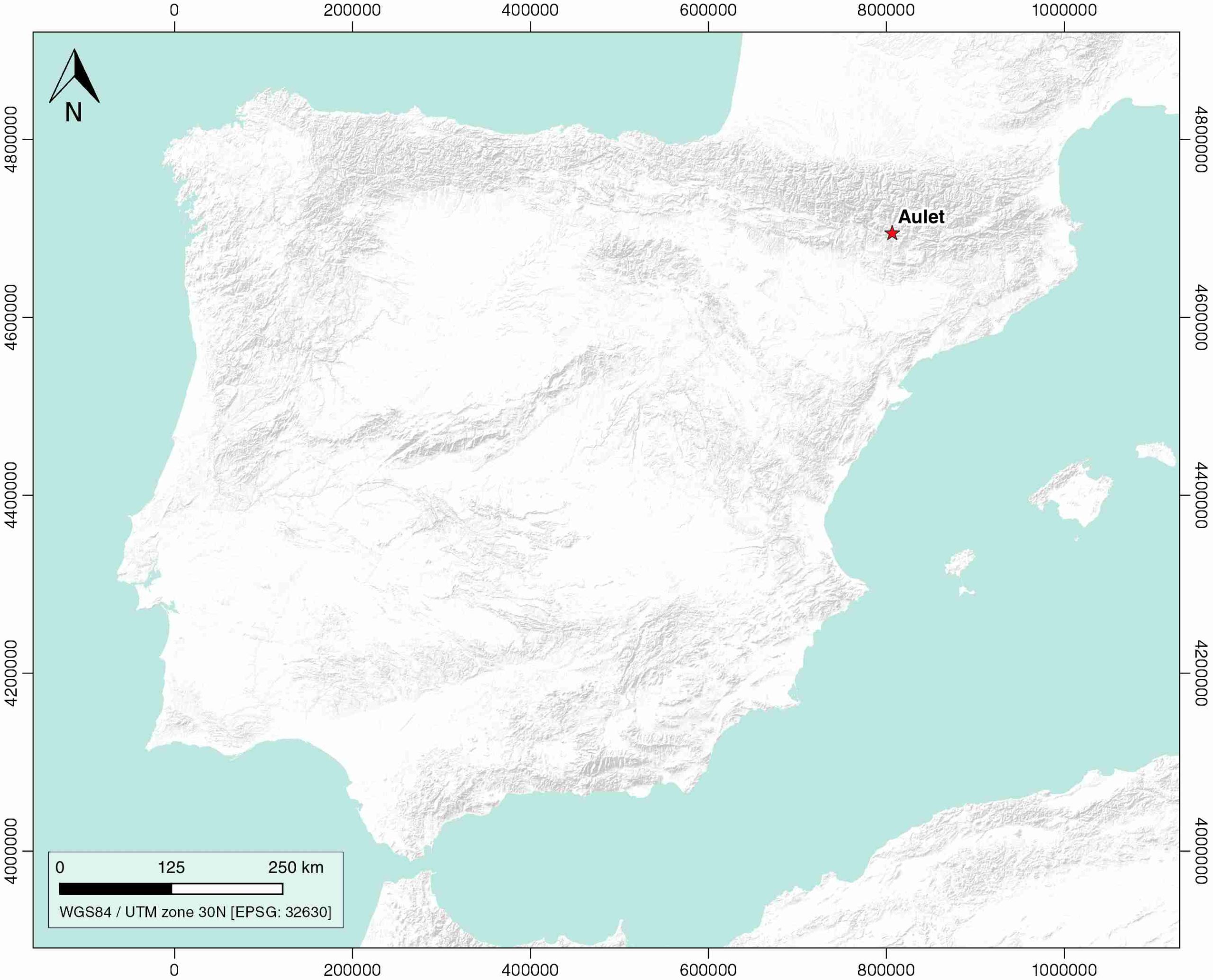
| Geological Setting | South Pyrenees Central Unit (Nogueres zone), Southern Pyrenees |
| Outcropping/buried | Outcropping |
| Evaporite unit/s name | El Pont de Suert Fm. |
| Evaporite unit/s age | Carnian-Rhaetian (Upper Triassic) |
| Evaporite unit/s origin | Marine |
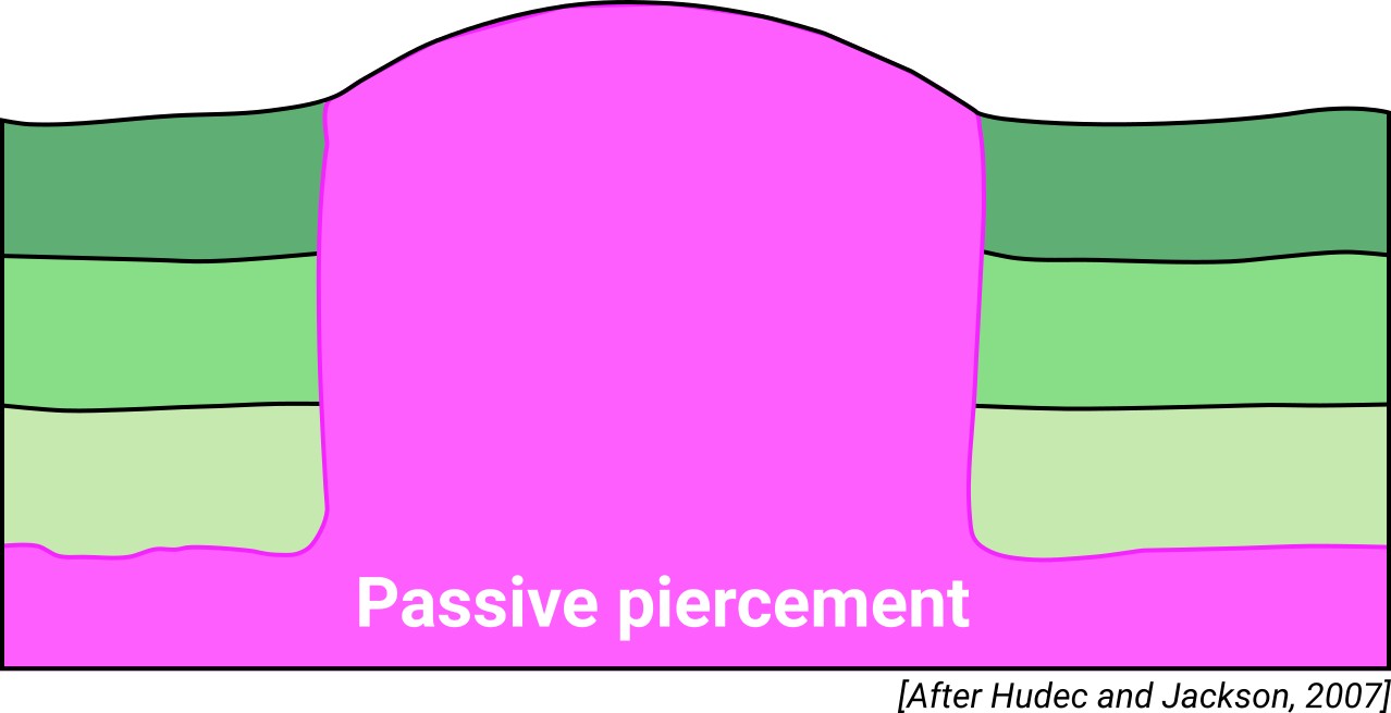
| Classif. (Hudec and Jackson, 2009) | Passive piercement |
| Classif. (Jackson and Talbot, 1986) | Salt roller, Welded |
| Age of evaporite flow or deformation (when deformed) | Albian to Santonian, Upper Jurassic to Lower Cretaceous |
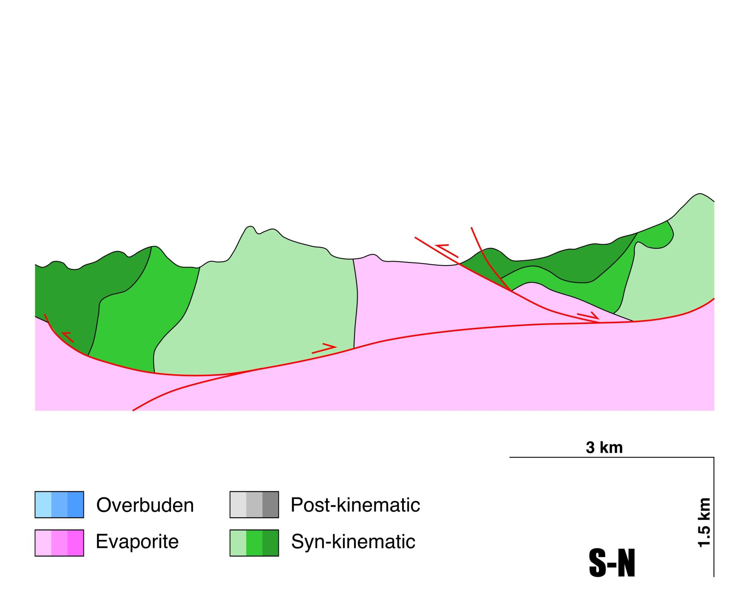
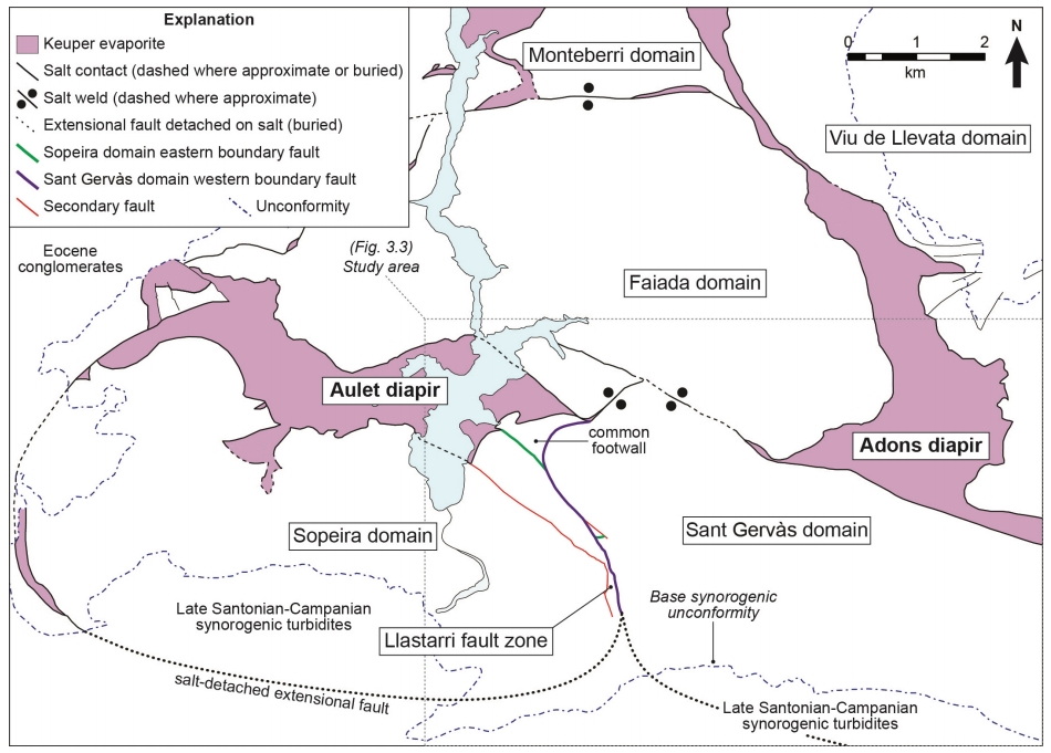
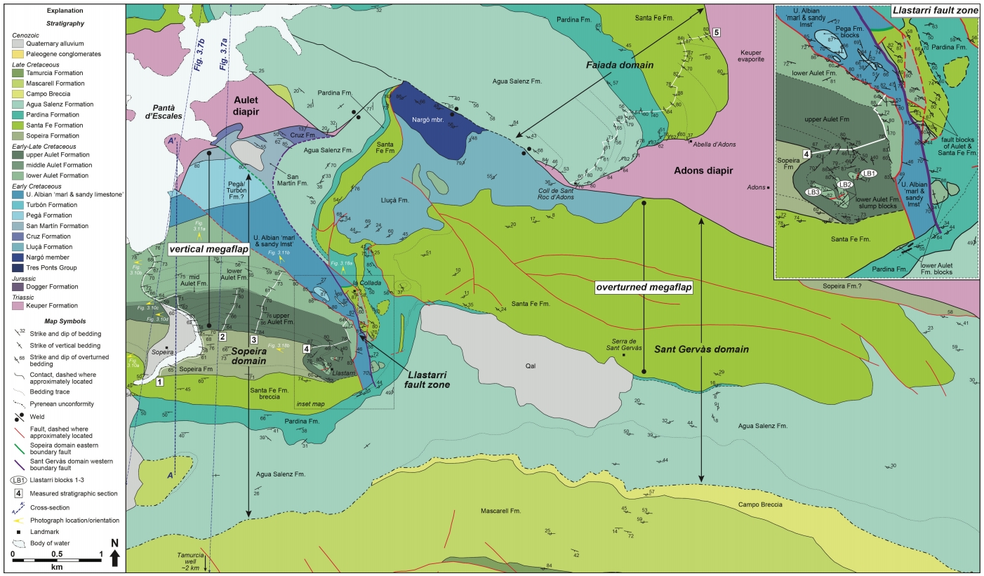
| Other comments | Post-late Santonian compressional overprinting: weld formation and partial downward salt flow into the source layer. Adons (ID #044) and Aulet diapirs are separated by a sub-vertical weld. |
Generic Data
| Unique ID | 19 |
| Name | Aulet |
| Structure type | Evaporite diapir |
| Deformed/Undeformed | Deformed |
| Buried/Outcropping | Outcropping |
| Geological setting | Southern Pyrenees |
| Geological Regional Setting | Nogueres Zone |
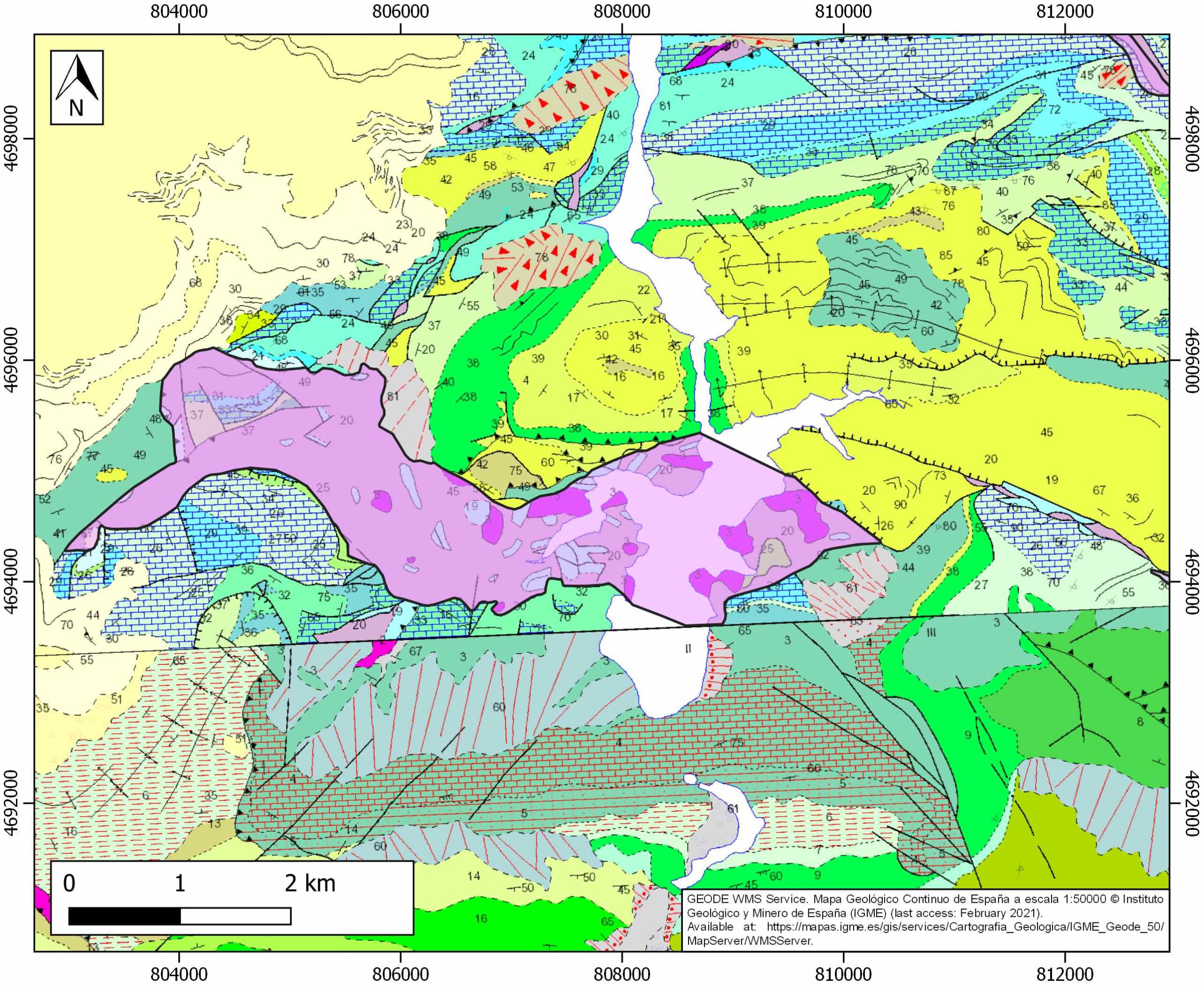
| Evaporite unit/s name | El Pont de Suert Fm. |
| Evaporite unit/s age | Carnian-Rhaetian (Upper Triassic) |
| Evaporite unit/s era | Mesozoic |
| Evaporite unit/s origin | Marine |
| Evaporite unit/s composition | Shale-Marlstone-Gypsum-Halite-Anhydrite |
| Post-kinematic unit/s (or post-evaporite units when evaporites are undeformed) | Quaternary (alluvial and colluvial detrital deposits) |
| Post-kinematic unit/s age (or post-evaporite units when evaporites are undeformed) | Holocene |
| Classification (Hudec and Jackson, 2009) | Passive piercement |
| Classification (Jackson and Talbot, 1986) | Salt roller |
| Mining activity? | N |
| Mining activity start | |
| Mining activity end | |
| Mining galleries? | |
| Mining products | |
| Mining sub-products | |
| Evaporite flow? | Y |
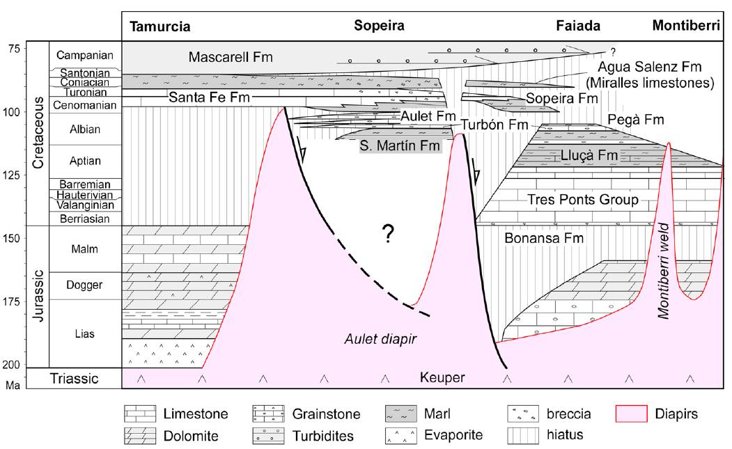
| Age of evaporite flow | Upper Jurassic – Early Albian (early stage) and Albian – Santonian (late stage) |
| Flow or deformation triggering mechanisms | Gravity-driven extensional event up to late Santonian: development of the Montiberri and Northern Faiada depocenters (early stage) and main development of the Sopeira depocenter (late stage) |
| Flow-linked structures? | Y |
| Halokinetic structures | Progressive unconformities / Normal faults |
| Post-evaporite and pre-kinematic unit/s (overbuden) | N |
| Syn-kinematic unit/s | Lower Cretaceous (limestones) / Albian-Cenomanian (grainstones) / Cenomanian (marls and limestones) / Cenomanian-Turonian (brecchias) / Turonian (limestones) / Coniacian-Santonian (limestones and brecchias) |
| Available seismic profiles | T-12 / ND-214 |
| Available boreholes | (Private Access): Tamurcia-1 / Cajigar-1 |
| Additional comments | Post-late Santonian compressional overprinting: weld formation and partial downward salt flow into the source layer. dons and Aulet diapirs are separated by a sub-vertical weld. |
Mining Data
| UNIQUE_ID | 19 |
| Minning exploitations within <2km? | N |
| Historical/Active | |
| Exploitation name #1 | |
| Exploitation ID (Spanish National Mining Cadastre) #1 | |
| Municipality #1 | |
| Province #1 | |
| Company #1 | |
| Main minning Products #1 | |
| Exploitation name #2 | |
| Exploitation ID (Spanish National Mining Cadastre) #2 | |
| Municipality #2 | |
| Province #2 | |
| Company #2 | |
| Main minning Products #2 | |
| Exploitation name #3 | |
| Exploitation ID (Spanish National Mining Cadastre) #3 | |
| Municipality #3 | |
| Province #3 | |
| Company #3 | |
| Main minning Products #3 |
Quantitative Data
| UNIQUE_ID | 19 |
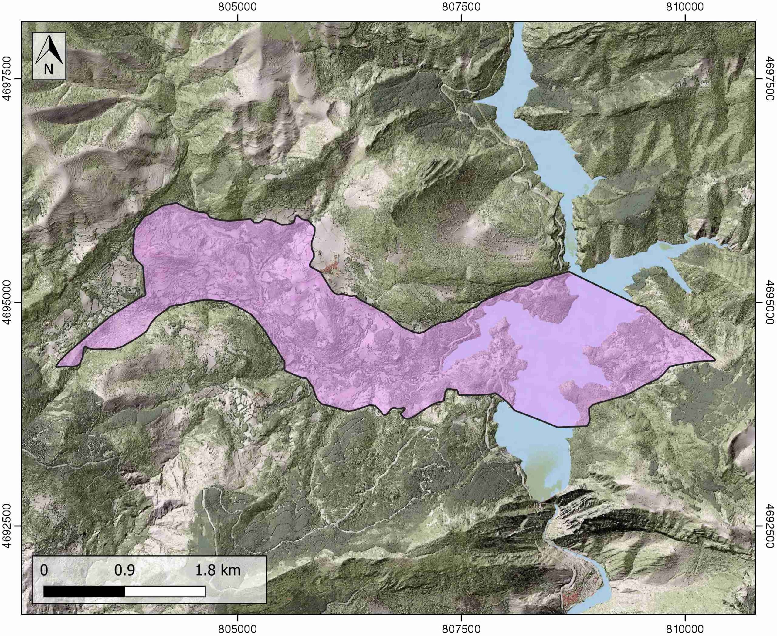
| Outcropping area (km2) | 7.38681 |
| Horizontal intersection area (km2) (when buried) | Not buried |
| Depth of intersection area (km2) (when buried) | Not buried |
| Max. Width (Km) | 2.3 |
| Max. Length (Km) | 7.4 |
| Max. Evaporites thickness (km) | 1.5 |
| Max. Deformation age (Ma) | 163.5 |
| Min. Deformation age (Ma) | 83.6 |
| Deformation stages | 2 |
Reference Data
| UNIQUE_ID | 19 |
| Section source | Saura, E., Ardèvol i Oró, L., Teixell, A., Vergés, J., 2016. Rising and falling diapirs, shifting depocenters, and flap overturning in the Cretaceous Sopeira and Sant Gervàs subbasins (Ribagorça Basin, southern Pyrenees). Tectonics, 35(3), 638-662. [link] |
| Well / Borehole availability #1 | Saura, E., Ardèvol i Oró, L., Teixell, A., Vergés, J., 2016. Rising and falling diapirs, shifting depocenters, and flap overturning in the Cretaceous Sopeira and Sant Gervàs subbasins (Ribagorça Basin, southern Pyrenees). Tectonics, 35(3), 638-662. [link] |
| Well / Borehole availability #2 | Ardèvol, L., Klimowitz, J., Malagón, J., Nagtegaal, P. J., 2000. Depositional sequence response to foreland deformation in the Upper Cretaceous of the Southern Pyrenees, Spain. AAPG bulletin, 84(4), 566-587. [link] |
| Available data (Stratigraphy) #1 | Dalton, C. E. G., 2019. Stratigraphic and Structural Characterization and Evolution of Exposed Megaflaps Flanking Salt Diapirs [Ph.D. thesis]: The University of Texas, El Paso, 273 pp. [link] |
| Available data (Stratigraphy) #2 | García-Senz, J. M., 2002. Cuencas extensivas del Cretácico inferior en los Pirineos Centrales, formación y subsecuente inversión [Ph.D. thesis]: Universitat de Barcelona, 294 p. [link] |
| Available data (Stratigraphy) #3 | Saura, E., Ardèvol i Oró, L., Teixell, A., Vergés, J., 2016. Rising and falling diapirs, shifting depocenters, and flap overturning in the Cretaceous Sopeira and Sant Gervàs subbasins (Ribagorça Basin, southern Pyrenees). Tectonics, 35(3), 638-662. [link] |
| Available data (Stratigraphy) #4 | Rosell, J., 1967. Estudio geológico del sector del Prepirineo comprendido entre los ríos Segre y Noguera Ribagorzana (Prov. de Lérida). Pirineos, 21, 214, Consejo Superior de Investigaciones Científicas, Madrid. [link] |
| Available data (Stratigraphy) #5 | Calvet, F., Anglada, E., Salvany, J.M., 2004. El Triásico de los Pirineos. In Vera, J.A., (ed.), Geología de España, pp. 272–274, SGE-IGME, Madrid. [link] |
| Available data (Stratigraphy) #6 | Caus, E., Teixell, A., Bernaus, J. M., 1997. Depositional model of a Cenomanian-Turonian extensional basin (Sopeira Basin, NE Spain): interplay between tectonics, eustasy and biological productivity. Palaeogeography, Palaeoclimatology, Palaeoecology, 129(1-2), 23-36. [link] |
| Regional Stratigraphy | Saura, E., Ardèvol i Oró, L., Teixell, A., Vergés, J., 2016. Rising and falling diapirs, shifting depocenters, and flap overturning in the Cretaceous Sopeira and Sant Gervàs subbasins (Ribagorça Basin, southern Pyrenees). Tectonics, 35(3), 638-662. [link] |
| Seismic data availability #1 | Saura, E., Ardèvol i Oró, L., Teixell, A., Vergés, J., 2016. Rising and falling diapirs, shifting depocenters, and flap overturning in the Cretaceous Sopeira and Sant Gervàs subbasins (Ribagorça Basin, southern Pyrenees). Tectonics, 35(3), 638-662. [link] |
| Seismic data availability #2 | Muñoz, J. A., Mencos, J., Roca, E., Carrera, N., Gratacós, O., Ferrer, O., Fernández, O., 2018. The structure of the South-Central-Pyrenean fold and thrust belt as constrained by subsurface data. Geologica Acta, 16(4), 439-460. [link] |
| Seismic data availability #3 | Dalton, C. E. G., 2019. Stratigraphic and Structural Characterization and Evolution of Exposed Megaflaps Flanking Salt Diapirs [Ph.D. thesis]: The University of Texas, El Paso, 273 pp. [link] |
| Available data (Structure) #1 | Saura, E., Ardèvol i Oró, L., Teixell, A., Vergés, J., 2016. Rising and falling diapirs, shifting depocenters, and flap overturning in the Cretaceous Sopeira and Sant Gervàs subbasins (Ribagorça Basin, southern Pyrenees). Tectonics, 35(3), 638-662. [link] |
| Available data (Structure) #2 | Flinch, J. F., Casas, J.M., 1996. Inversion of a transfer system into lateral ramps: An example from the South-Central Pyrenees (Spain). Geol. Rundsch., 85, 372–379. [link] |
| Available data (Structure) #3 | Martín-Chivelet, J., Floquet, M., García-Senz, J., Callapez, P. M., López-Mir, B., Muñoz, J. A., …, Marques, J. F., 2019. Late Cretaceous Post-Rift to Convergence in Iberia. In The Geology of Iberia: A Geodynamic Approach (pp. 285-376). Springer, Cham. [link] |
| Available data (Structure) #4 | Dalton, C. E. G., 2019. Stratigraphic and Structural Characterization and Evolution of Exposed Megaflaps Flanking Salt Diapirs [Ph.D. thesis]: The University of Texas, El Paso, 273 pp. [link] |
| Available data (Structure) #5 | García-Senz, J. M., 2002. Cuencas extensivas del Cretácico inferior en los Pirineos Centrales, formación y subsecuente inversión [Ph.D. thesis]: Universitat de Barcelona, 294 p. [link] |
| Available data (Structure) #6 | Muñoz, J. A., Mencos, J., Roca, E., Carrera, N., Gratacós, O., Ferrer, O., Fernández, O., 2018. The structure of the South-Central-Pyrenean fold and thrust belt as constrained by subsurface data. Geologica Acta, 16(4), 439-460. [link] |
| Available data (Analogue modelling) #1 | n.a. |
| Available data (Analogue modelling) #2 | n.a. |
| Available data (Analogue modelling) #3 | n.a. |
| Available data (Gravimetry – Tomography) #1 | ICGC, 2012. Mapa Gravimètric de Catalunya 1:500.000. Barcelona, Servei Geològic de Catalunya. [link] |
| Available data (Gravimetry – Tomography) #2 | Ayala, C., Bohoyo, F., Maestro, A., Reguera, M. I., Torne, M., Rubio, F., Fernández, M., García-Lobón, J. L., 2016. Updated Bouguer anomalies of the Iberian Peninsula: a new perspective to interpret the regional geology. Journal of Maps, 12(5), 1089-1092. [link] |
| Available data (Gravimetry – Tomography) #3 | n.a. |
| Available data (Geochemistry) #1 | Ortí, F., García-Veigas, J., Rossell, L., Jurado, M. J., Utrilla, R., 1996. Formaciones salinas de las cuencas triásicas en la Península Ibérica: Caracterización Petrológica y Geoquímica. Cuadernos de Geología Ibérica, 20, 13-35. [link] |
| Available data (Geochemistry) #2 | n.a. |
| Available data (Geochemistry) #3 | n.a. |
| Available data (Geochemistry) #4 | n.a. |
| Available data (Petrophysics) #1 | Santolaria, P., Casas-Sainz, A. M., Soto, R., Casas, A., 2017. Gravity modelling to assess salt tectonics in the western end of the South Pyrenean Central Unit. Journal of the Geological Society, 174(2), 269-288. [link] |
| Available data (Petrophysics) #2 | n.a. |
| IGME Geological Map (MAGNA50) Sheet number | 213-El Pont de Suert. [link] |
| Other Maps #1 (source) | Dalton, C. E. G., 2019. Stratigraphic and Structural Characterization and Evolution of Exposed Megaflaps Flanking Salt Diapirs [Ph.D. thesis]: The University of Texas, El Paso, 273 pp. [link] |
| Other Maps #2 (source) | Dalton, C. E. G., 2019. Stratigraphic and Structural Characterization and Evolution of Exposed Megaflaps Flanking Salt Diapirs [Ph.D. thesis]: The University of Texas, El Paso, 273 pp. [link] |
| Other related references #1 | Lanaja, J. M., R. Querol, A. Navarro, 1987. Contribución de la Exploración Petrolífera al Conocimiento de la Geología de España, pp. 1–465, Instituto Geológico y Minero de España, Madrid. [link] |
| Other related references #2 | Rosell, J., 1967. Estudio geológico del sector del Prepirineo comprendido entre los ríos Segre y Noguera Ribagorzana (Prov. de Lérida). Pirineos, 21, 214, Consejo Superior de Investigaciones Científicas, Madrid. [link] |
| Other related references #3 | Robert, R., Robion, P., Souloumiac, P., David, C., Saillet, E., 2018. Deformation bands, early markers of tectonic activity in front of a fold-and-thrust belt: Example from the Tremp-Graus basin, southern Pyrenees, Spain. Journal of Structural Geology, 110, 65-85. [link] |
| Other related references #4 | Teixell, A., Muñoz, J. A., 2000. Evolución tectonosedimentaria del Pirineo meridional durante el Terciario: una síntesis basada en la transversal del río Noguera Ribagorçana. Revista de la Sociedad Geológica de España, 13(2), 251-264. [link] |
Well and Seismic Data
| UNIQUE_ID | 19 |
| Seismic survey name #1 | 11D1-T |
| Across structure? #1 | N (within 3km) |
| Seismic profile ID (IGME) #1 | 10284 |
| Seismic profile code #1 | 14912 |
| Seismic profile name #1 | T-12 |
| Seismic survey year #1 | 1968 |
| Data repository #1 | SIGEOF Data Catalogue (Section available under request). ©Instituto Geológico y Minero de España (IGME). https://info.igme.es/SIGEOF/ |
| Length (km) #1 | 5.08 |
| Seismic survey name #2 | 11D1-ND |
| Across structure? #2 | N (within 3km) |
| Seismic profile ID (IGME) #2 | 10158 |
| Seismic profile code #2 | 14786 |
| Seismic profile name #2 | ND-214 |
| Seismic survey year #2 | 1962 |
| Data repository #2 | SIGEOF Data Catalogue (Section available under request). ©Instituto Geológico y Minero de España (IGME). https://info.igme.es/SIGEOF/ |
| Length (km) #2 | 9.02 |
| Seismic survey name #3 | |
| Across structure? #3 | |
| Seismic profile ID (IGME) #3 | |
| Seismic profile code #3 | |
| Seismic profile name #3 | |
| Seismic survey year #3 | |
| Data repository #3 | |
| Length (km) #3 | |
| Seismic survey name #4 | |
| Across structure? #4 | |
| Seismic profile ID (IGME) #4 | |
| Seismic profile code #4 | |
| Seismic profile name #4 | |
| Seismic survey year #4 | |
| Data repository #4 | |
| Length (km) #4 | |
| Seismic survey name #5 | |
| Across structure? #5 | |
| Seismic profile ID (IGME) #5 | |
| Seismic profile code #5 | |
| Seismic profile name #5 | |
| Seismic survey year #5 | |
| Data repository #5 | |
| Length (km) #5 | |
| Seismic survey name #6 | |
| Across structure? #6 | |
| Seismic profile ID (IGME) #6 | |
| Seismic profile code #6 | |
| Seismic profile name #6 | |
| Seismic survey year #6 | |
| Data repository #6 | |
| Length (km) #6 | |
| Seismic survey name #7 | |
| Across structure? #7 | |
| Seismic profile ID (IGME) #7 | |
| Seismic profile code #7 | |
| Seismic profile name #7 | |
| Seismic survey year #7 | |
| Data repository #7 | |
| Length (km) #7 | |
| Seismic survey name #8 | |
| Across structure? #8 | |
| Seismic profile ID (IGME) #8 | |
| Seismic profile code #8 | |
| Seismic profile name #8 | |
| Seismic survey year #8 | |
| Data repository #8 | |
| Length (km) #8 | |
| Seismic survey name #9 | |
| Across structure? #9 | |
| Seismic profile ID (IGME) #9 | |
| Seismic profile code #9 | |
| Seismic profile name #9 | |
| Seismic survey year #9 | |
| Data repository #9 | |
| Length (km) #9 | |
| Seismic survey name #10 | |
| Across structure? #10 | |
| Seismic profile ID (IGME) #10 | |
| Seismic profile code #10 | |
| Seismic profile name #10 | |
| Seismic survey year #10 | |
| Data repository #10 | |
| Length (km) #10 | |
| Seismic survey name #11 | |
| Across structure? #11 | |
| Seismic profile ID (IGME) #11 | |
| Seismic profile code #11 | |
| Seismic profile name #11 | |
| Seismic survey year #11 | |
| Data repository #11 | |
| Length (km) #11 | |
| Seismic survey name #12 | |
| Across structure? #12 | |
| Seismic profile ID (IGME) #12 | |
| Seismic profile code #12 | |
| Seismic profile name #12 | |
| Seismic survey year #12 | |
| Data repository #12 | |
| Length (km) #12 | |
| Seismic survey name #13 | |
| Across structure? #13 | |
| Seismic profile ID (IGME) #13 | |
| Seismic profile code #13 | |
| Seismic profile name #13 | |
| Seismic survey year #13 | |
| Data repository #13 | |
| Length (km) #13 | |
| Seismic survey name #14 | |
| Across structure? #14 | |
| Seismic profile ID (IGME) #14 | |
| Seismic profile code #14 | |
| Seismic profile name #14 | |
| Seismic survey year #14 | |
| Data repository #14 | |
| Length (km) #14 | |
| Seismic survey name #15 | |
| Across structure? #15 | |
| Seismic profile ID (IGME) #15 | |
| Seismic profile code #15 | |
| Seismic profile name #15 | |
| Seismic survey year #15 | |
| Data repository #15 | |
| Length (km) #15 | |
| Seismic survey name #16 | |
| Across structure? #16 | |
| Seismic profile ID (IGME) #16 | |
| Seismic profile code #16 | |
| Seismic profile name #16 | |
| Seismic survey year #16 | |
| Data repository #16 | |
| Length (km) #16 | |
| Seismic survey name #17 | |
| Across structure? #17 | |
| Seismic profile ID (IGME) #17 | |
| Seismic profile code #17 | |
| Seismic profile name #17 | |
| Seismic survey year #17 | |
| Data repository #17 | |
| Length (km) #17 | |
| Seismic survey name #18 | |
| Across structure? #18 | |
| Seismic profile ID (IGME) #18 | |
| Seismic profile code #18 | |
| Seismic profile name #18 | |
| Seismic survey year #18 | |
| Data repository #18 | |
| Length (km) #18 | |
| Seismic survey name #19 | |
| Across structure? #19 | |
| Seismic profile ID (IGME) #19 | |
| Seismic profile code #19 | |
| Seismic profile name #19 | |
| Seismic survey year #19 | |
| Data repository #19 | |
| Length (km) #19 | |
| Seismic survey name #20 | |
| Across structure? #20 | |
| Seismic profile ID (IGME) #20 | |
| Seismic profile code #20 | |
| Seismic profile name #20 | |
| Seismic survey year #20 | |
| Data repository #20 | |
| Length (km) #20 | |
| Seismic survey name #21 | |
| Across structure? #21 | |
| Seismic profile ID (IGME) #21 | |
| Seismic profile code #21 | |
| Seismic profile name #21 | |
| Seismic survey year #21 | |
| Data repository #21 | |
| Length (km) #21 | |
| Borehole name #1 | |
| Company #1 | |
| Traget #1 | |
| Across structure? #1 | |
| Borehole name #2 | |
| Company #2 | |
| Traget #2 | |
| Across structure? #2 | |
| Borehole name #3 | |
| Company #3 | |
| Traget #3 | |
| Across structure? #3 | |
| Borehole name #4 | |
| Company #4 | |
| Traget #4 | |
| Across structure? #4 | |
| Borehole name #5 | |
| Company #5 | |
| Traget #5 | |
| Across structure? #5 | |
| Borehole name #6 | |
| Company #6 | |
| Traget #6 | |
| Across structure? #6 | |
| Borehole name #7 | |
| Company #7 | |
| Traget #7 | |
| Across structure? #7 | |
| Borehole name #8 | |
| Company #8 | |
| Traget #8 | |
| Across structure? #8 | |
| Borehole name #9 | |
| Company #9 | |
| Traget #9 | |
| Across structure? #9 | |
| Borehole name #10 | |
| Company #10 | |
| Traget #10 | |
| Across structure? #10 | |
| Borehole name #11 | |
| Company #11 | |
| Traget #11 | |
| Across structure? #11 | |
| Borehole name #12 | |
| Company #12 | |
| Traget #12 | |
| Across structure? #12 | |
| Borehole name #13 | |
| Company #13 | |
| Traget #13 | |
| Across structure? #13 | |
| Borehole name #14 | |
| Company #14 | |
| Traget #14 | |
| Across structure? #14 | |
| Borehole name #15 | |
| Company #15 | |
| Traget #15 | |
| Across structure? #15 |
Geographical Data (EPSG:4326 - WGS 84)
| UNIQUE_ID | 19 |
| X Centroid (Structure shape) | 0.724385 |
| Y Centroid (Structure shape) | 0.724385 |
| Xmin (Structure shape) | 0.677781 |
| Xmax (Structure shape) | 0.767073 |
| Ymin (Structure shape) | 42.333484 |
| Ymax (Structure shape) | 42.357738 |
| Xmin seismic line #1 | 0.739007 |
| Xmax seismic line #1 | 0.770427 |
| Ymin seismic line #1 | 42.267913 |
| Ymax seismic line #1 | 42.307094 |
| Xmin seismic line #2 | 0.563459 |
| Xmax seismic line #2 | 0.653734 |
| Ymin seismic line #2 | 42.280609 |
| Ymax seismic line #2 | 42.326271 |
| Xmin seismic line #3 | |
| Xmax seismic line #3 | |
| Ymin seismic line #3 | |
| Ymax seismic line #3 | |
| Xmin seismic line #4 | |
| Xmax seismic line #4 | |
| Ymin seismic line #4 | |
| Ymax seismic line #4 | |
| Xmin seismic line #5 | |
| Xmax seismic line #5 | |
| Ymin seismic line #5 | |
| Ymax seismic line #5 | |
| Xmin seismic line #6 | |
| Xmax seismic line #6 | |
| Ymin seismic line #6 | |
| Ymax seismic line #6 | |
| Xmin seismic line #7 | |
| Xmax seismic line #7 | |
| Ymin seismic line #7 | |
| Ymax seismic line #7 | |
| Xmin seismic line #8 | |
| Xmax seismic line #8 | |
| Ymin seismic line #8 | |
| Ymax seismic line #8 | |
| Xmin seismic line #9 | |
| Xmax seismic line #9 | |
| Ymin seismic line #9 | |
| Ymax seismic line #9 | |
| Xmin seismic line #10 | |
| Xmax seismic line #10 | |
| Ymin seismic line #10 | |
| Ymax seismic line #10 | |
| Xmin seismic line #11 | |
| Xmax seismic line #11 | |
| Ymin seismic line #11 | |
| Ymax seismic line #11 | |
| Xmin seismic line #12 | |
| Xmax seismic line #12 | |
| Ymin seismic line #12 | |
| Ymax seismic line #12 | |
| Xmin seismic line #13 | |
| Xmax seismic line #13 | |
| Ymin seismic line #13 | |
| Ymax seismic line #13 | |
| Xmin seismic line #14 | |
| Xmax seismic line #14 | |
| Ymin seismic line #14 | |
| Ymax seismic line #14 | |
| Xmin seismic line #15 | |
| Xmax seismic line #15 | |
| Ymin seismic line #15 | |
| Ymax seismic line #15 | |
| Xmin seismic line #16 | |
| Xmax seismic line #16 | |
| Ymin seismic line #16 | |
| Ymax seismic line #16 | |
| Xmin seismic line #17 | |
| Xmax seismic line #17 | |
| Ymin seismic line #17 | |
| Ymax seismic line #17 | |
| Xmin seismic line #18 | |
| Xmax seismic line #18 | |
| Ymin seismic line #18 | |
| Ymax seismic line #18 | |
| Xmin seismic line #19 | |
| Xmax seismic line #19 | |
| Ymin seismic line #19 | |
| Ymax seismic line #19 | |
| Xmin seismic line #20 | |
| Xmax seismic line #20 | |
| Ymin seismic line #20 | |
| Ymax seismic line #20 | |
| Xmin seismic line #21 | |
| Xmax seismic line #21 | |
| Ymin seismic line #21 | |
| Ymax seismic line #21 | |
| X borehole #1 | |
| Y borehole #1 | |
| X borehole #2 | |
| Y borehole #2 | |
| X borehole #3 | |
| Y borehole #3 | |
| X borehole #4 | |
| Y borehole #4 | |
| X borehole #5 | |
| Y borehole #5 | |
| X borehole #6 | |
| Y borehole #6 | |
| X borehole #7 | |
| Y borehole #7 | |
| X borehole #8 | |
| Y borehole #8 | |
| X borehole #9 | |
| Y borehole #9 | |
| X borehole #10 | |
| Y borehole #10 | |
| X borehole #11 | |
| Y borehole #11 | |
| X borehole #12 | |
| Y borehole #12 | |
| X borehole #13 | |
| Y borehole #13 | |
| X borehole #14 | |
| Y borehole #14 | |
| X borehole #15 | |
| Y borehole #15 |

