General Information
| Structure type | Evaporite Diapir |
| Deformed/Undeformed | Deformed |
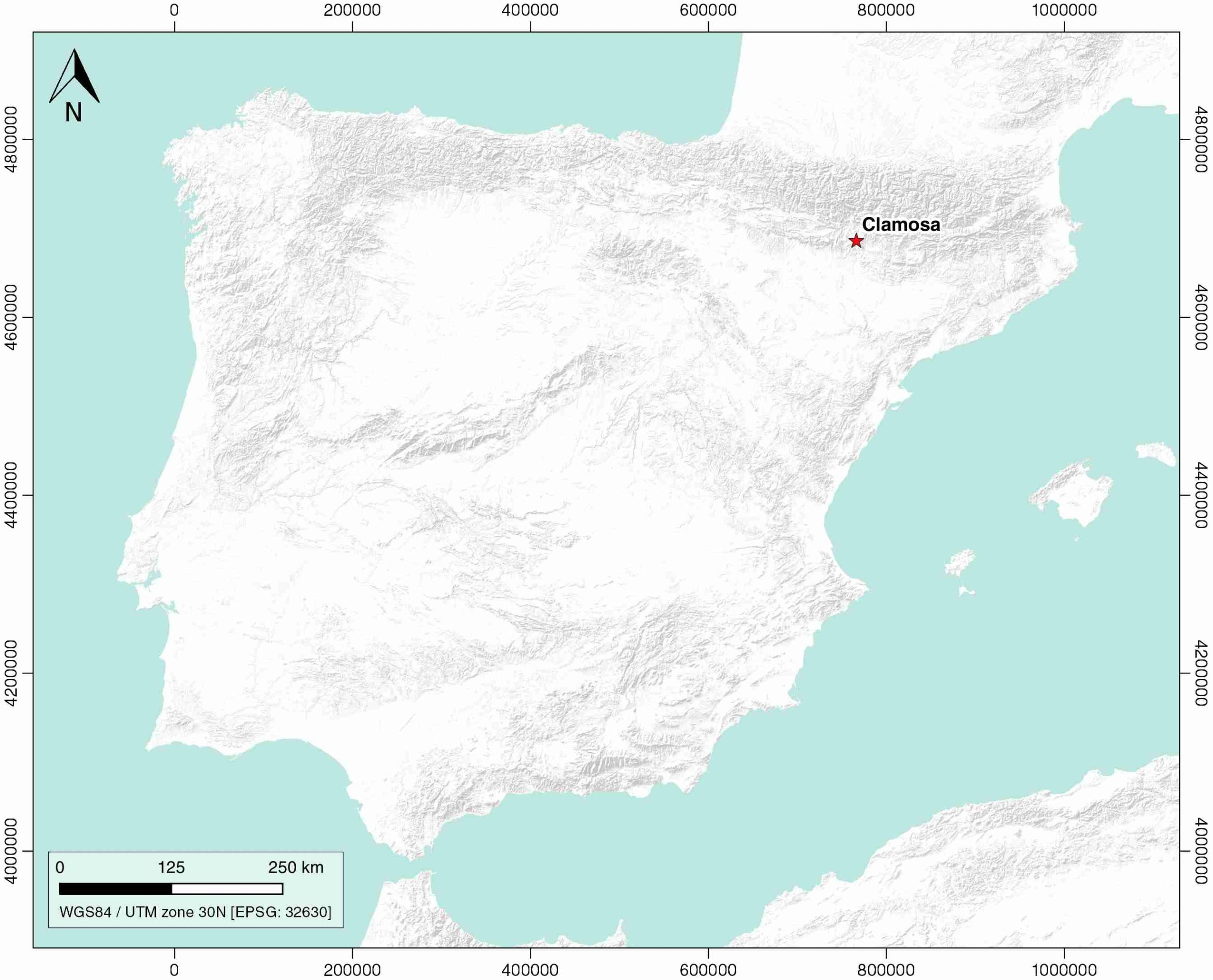
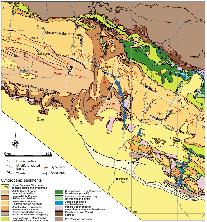
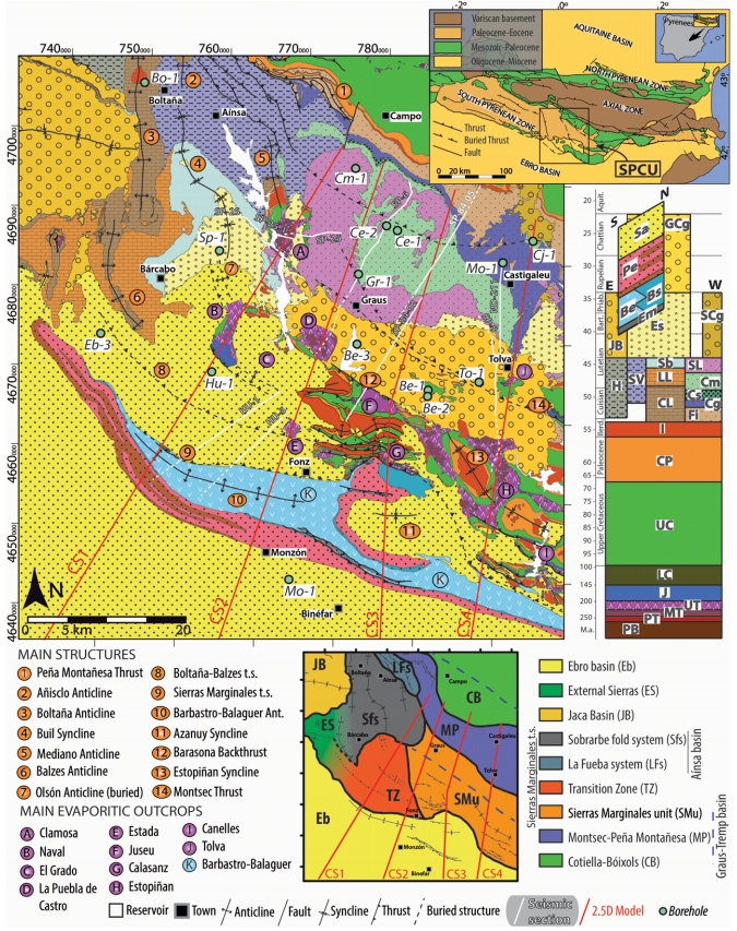
| Geological Setting | South Pyrenees Central Unit (Sierras Marginales; Boltaña-Balzes thrust sheet), Southern Pyrenees |
| Outcropping/buried | Outcropping |
| Evaporite unit/s name | Keuper facies |
| Evaporite unit/s age | Carnian-Rhaetian (Upper Triassic) |
| Evaporite unit/s origin | Marine |
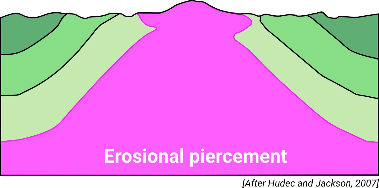
| Classif. (Hudec and Jackson, 2009) | Erosional piercement |
| Classif. (Jackson and Talbot, 1986) | Salt glacier |
| Age of evaporite flow or deformation (when deformed) | Eocene |
| Other comments | Host rocks show a unusual, reduced piercement (see Teixell and Barnolas 1995). The diapir is surrounded by a thicker overburden and a significant thickness of syntectonic deposits of the Graus–Tremp Basin. Genetically linked to the Mediano salt-cored anticline (ID #066): pop-up structure evolved from the salt-cored Mediano anticline during Lutetian. |
Generic Data
| Unique ID | 54 |
| Name | Clamosa |
| Structure type | Evaporite diapir |
| Deformed/Undeformed | Deformed |
| Buried/Outcropping | Outcropping |
| Geological setting | Southern Pyrenees |
| Geological Regional Setting | South Pyrenees Central Unit (Sierras Marginales; Boltaña-Balzes thrust sheet) |
| Evaporite unit/s name | Keuper facies |
| Evaporite unit/s age | Carnian-Rhaetian (Upper Triassic) |
| Evaporite unit/s era | Mesozoic |
| Evaporite unit/s origin | Marine |
| Evaporite unit/s composition | Shale-Marlstone-Gypsum-Halite-Anhydrite |
| Post-kinematic unit/s (or post-evaporite units when evaporites are undeformed) | Quaternary (alluvial and colluvial detrital deposits) |
| Post-kinematic unit/s age (or post-evaporite units when evaporites are undeformed) | Pleistocene-Holocene |
| Classification (Hudec and Jackson, 2009) | Erosional piercement |
| Classification (Jackson and Talbot, 1986) | Salt glacier |
| Mining activity? | N |
| Mining activity start | |
| Mining activity end | |
| Mining galleries? | |
| Mining products | |
| Mining sub-products | |
| Evaporite flow? | Y |
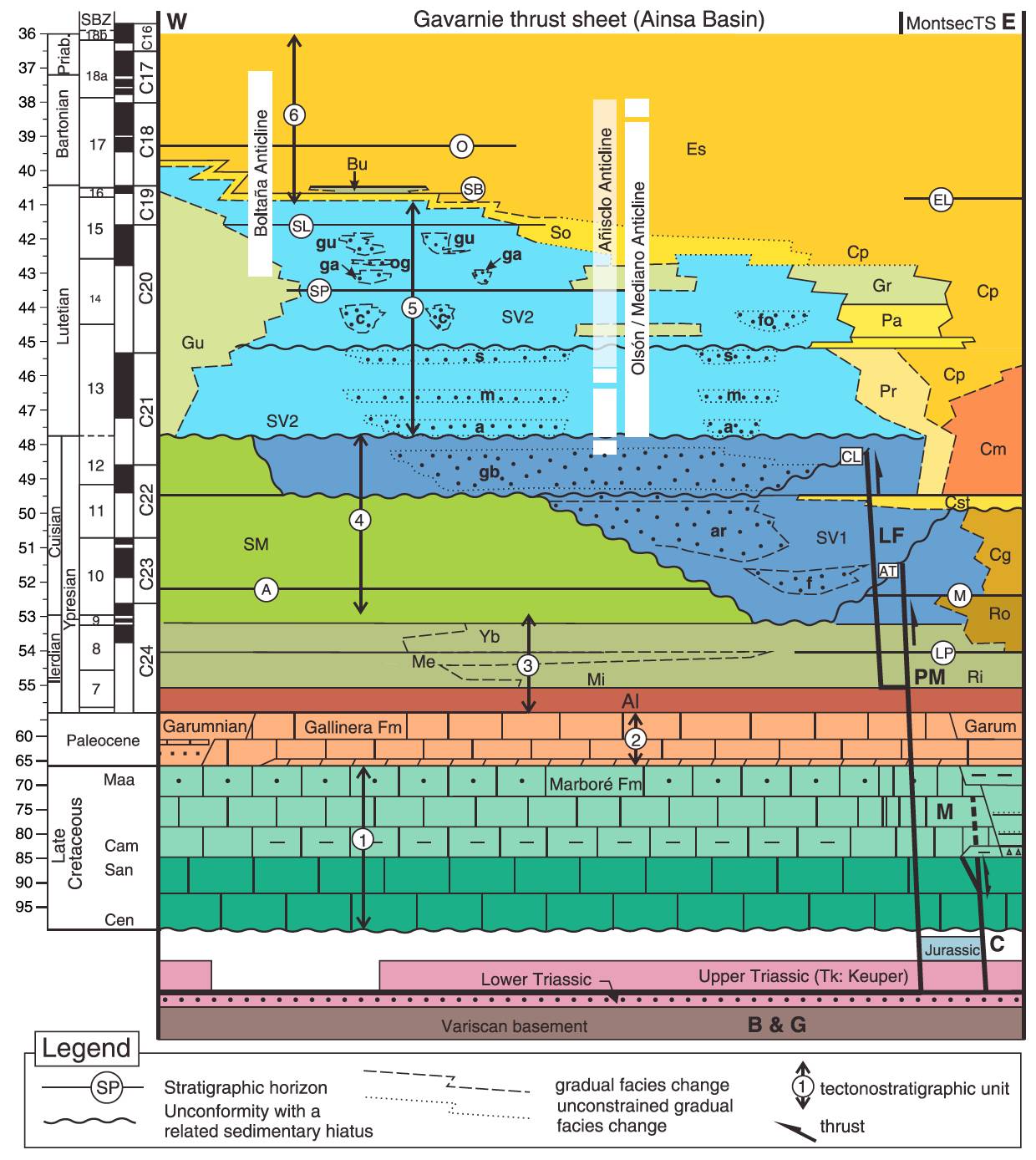
| Age of evaporite flow | Cuisian (Salt inflation), Lutetian (piercement), Oligocene (Crestal Colapse) |
| Flow or deformation triggering mechanisms | Contraction / Sedimentary loading and thrust stacking / anticline crest erosion / strike-parallel local extension of a salt-cored detachment fold |
| Flow-linked structures? | Y |
| Halokinetic structures | Progressive unconformities / Normal faults / Thickness variations |
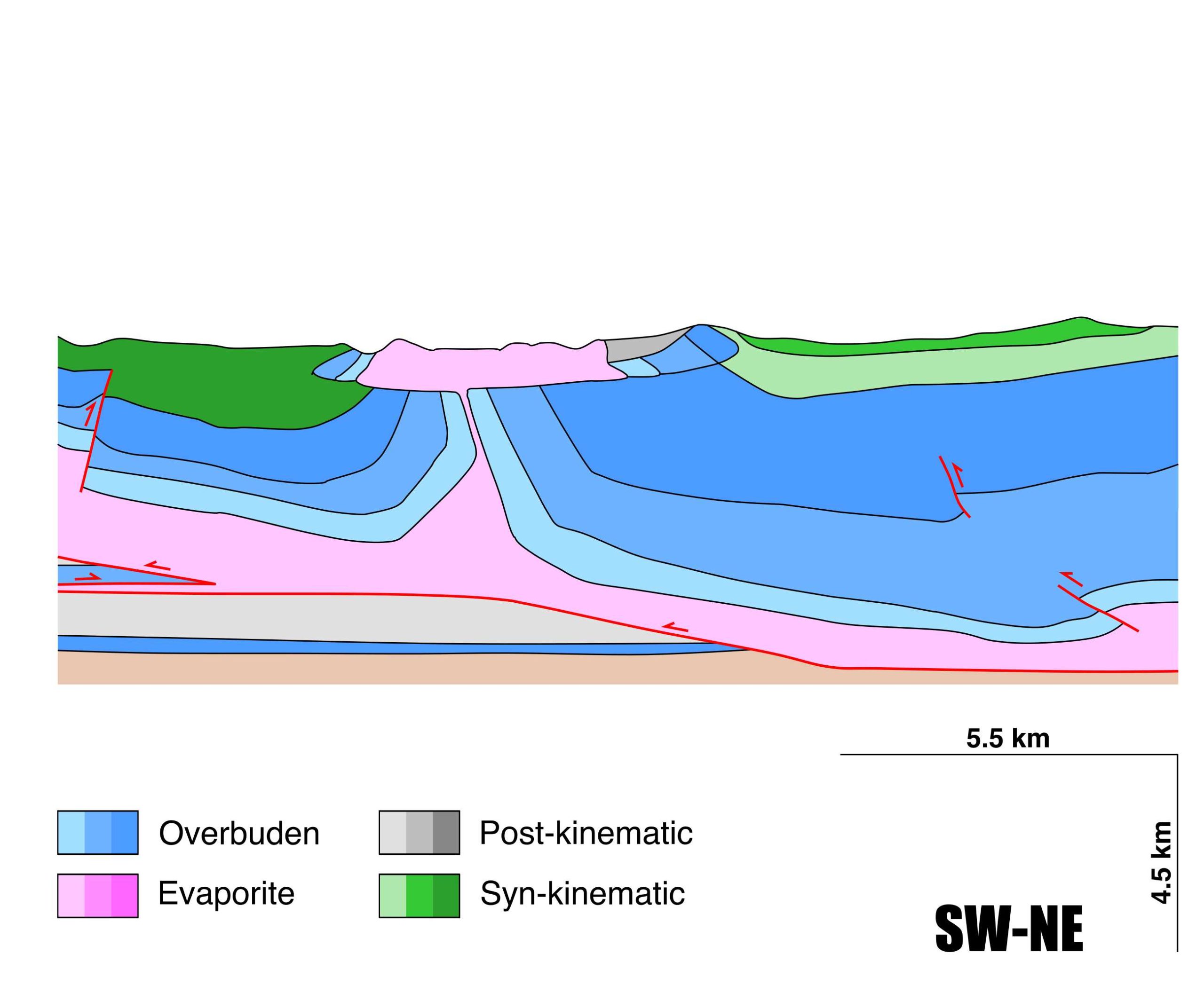
| Post-evaporite and pre-kinematic unit/s (overbuden) | Jurassic (carbonate breccias, marlstones, limestones) ; Upper Cretaceous (Garumn Facies, calcarenites and limestones) ; Illerdian-Middle Cuisian (limestones, marlstones, calcarenites) |
| Syn-kinematic unit/s | Upper Cuisian(?) (Boltaña Fm., limestones) / Lutetian (Guara Fm., limestones) |
| Available seismic profiles | SP-25 / SP-25 / SP-25 / SP-25(1) / SP-25-1 / SP-25 / SP-25 / SP-15 / SP-17 / SP-84-17 / JAT-98 / SP-25-1 / SP-5 / SP-1 / SP-25 / SP-25 / SP-17 / ND-102 / SP-17 / SP-84-17 / SP-25(1) |
| Available boreholes | PANILLO-EJEP |
| Additional comments | Host rocks show a unusual, reduced piercement (see Teixell and Barnolas 1995). The diapir is surrounded by a thicker overburden and a significant thickness of syntectonic deposits of the Graus–Tremp Basin. Genetically linked to the Mediano salt-cored anticline: pop-up structure evolved from the salt-cored Mediano anticline during Lutetian. |
Mining Data
| UNIQUE_ID | 54 |
| Minning exploitations within <2km? | N |
| Historical/Active | |
| Exploitation name #1 | |
| Exploitation ID (Spanish National Mining Cadastre) #1 | |
| Municipality #1 | |
| Province #1 | |
| Company #1 | |
| Main minning Products #1 | |
| Exploitation name #2 | |
| Exploitation ID (Spanish National Mining Cadastre) #2 | |
| Municipality #2 | |
| Province #2 | |
| Company #2 | |
| Main minning Products #2 | |
| Exploitation name #3 | |
| Exploitation ID (Spanish National Mining Cadastre) #3 | |
| Municipality #3 | |
| Province #3 | |
| Company #3 | |
| Main minning Products #3 |
Quantitative Data
| UNIQUE_ID | 54 |
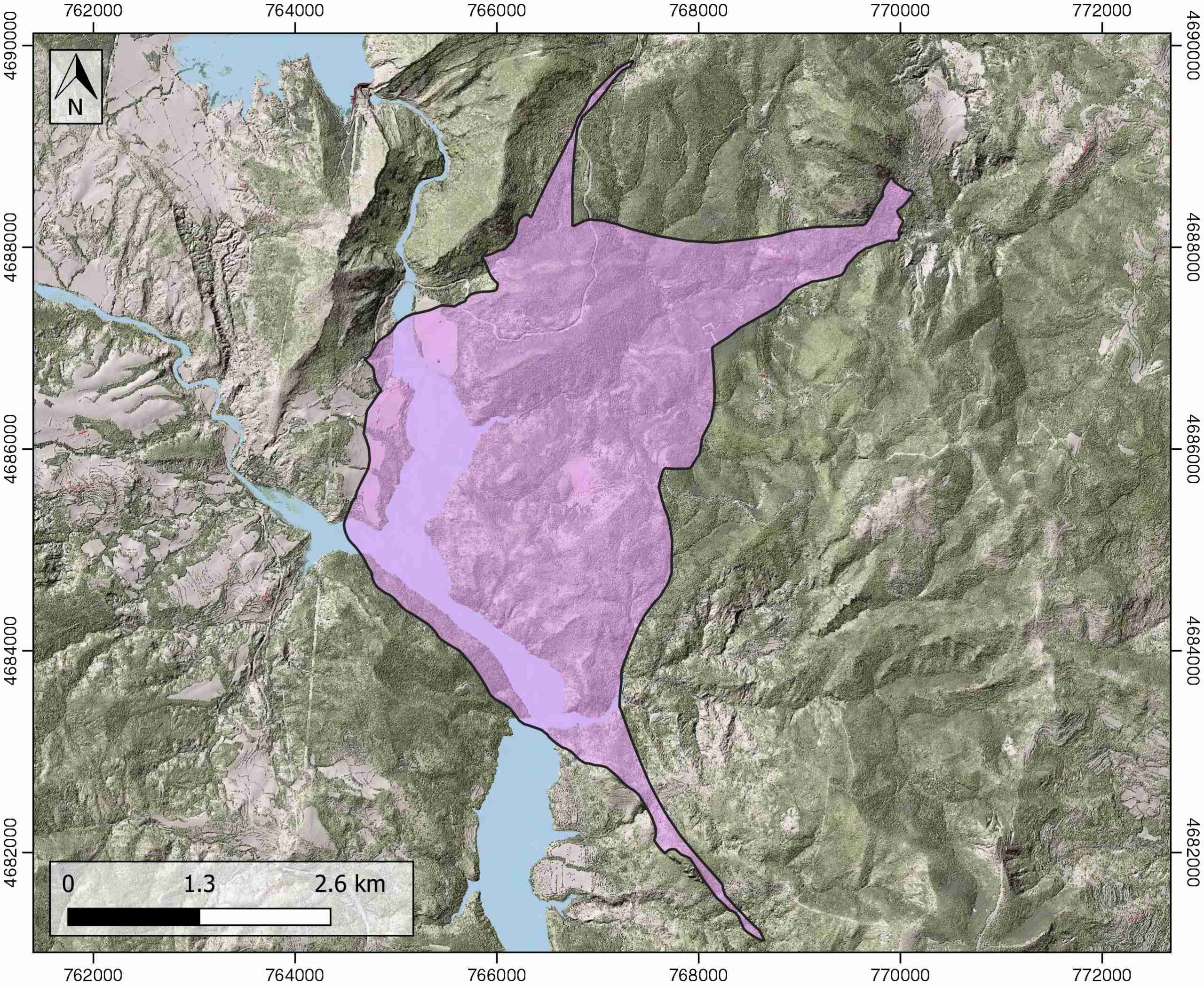
| Outcropping area (km2) | 14.97275 |
| Horizontal intersection area (km2) (when buried) | Not buried |
| Depth of intersection area (km2) (when buried) | Not buried |
| Max. Width (Km) | 8.35148804 |
| Max. Length (Km) | 5.05685705 |
| Max. Evaporites thickness (km) | 3 |
| Max. Deformation age (Ma) | 49 |
| Min. Deformation age (Ma) | 42 |
| Deformation stages | 1 |
Reference Data
| UNIQUE_ID | 54 |
| Section source | Santolaria, P., Casas-Sainz, A. M., Soto, R., Casas, A., 2017. Gravity modelling to assess salt tectonics in the western end of the South Pyrenean Central Unit. Journal of the Geological Society, 174(2), 269-288. [link] |
| Well / Borehole availability #1 | Soto, R., Casas, A. M., Storti, F., & Faccenna, C. (2002). Role of lateral thickness variations on the development of oblique structures at the Western end of the South Pyrenean Central Unit. Tectonophysics, 350(3), 215-235. [link] |
| Well / Borehole availability #2 | Santolaria, P., Casas-Sainz, A. M., Soto, R., Casas, A., 2017. Gravity modelling to assess salt tectonics in the western end of the South Pyrenean Central Unit. Journal of the Geological Society, 174(2), 269-288. [link] |
| Available data (Stratigraphy) #1 | Soto, R., Casas, A. M., Storti, F., & Faccenna, C. (2002). Role of lateral thickness variations on the development of oblique structures at the Western end of the South Pyrenean Central Unit. Tectonophysics, 350(3), 215-235. [link] |
| Available data (Stratigraphy) #2 | Teixell, A., Barnolas, A., 1995. Significado de la discordancia de Mediano en relación con las estructuras adyacentes (Eoceno, Pirineo Central). Geogaceta, 18, 34-37. [link] |
| Available data (Stratigraphy) #3 | Santolaria, P., Casas-Sainz, A. M., Soto, R., Casas, A., 2017. Gravity modelling to assess salt tectonics in the western end of the South Pyrenean Central Unit. Journal of the Geological Society, 174(2), 269-288. [link] |
| Available data (Stratigraphy) #4 | Muñoz, J. A., Beamud, E., Fernández, O., Arbués, P., Dinarès‐Turell, J., Poblet, J., 2013. The Ainsa Fold and thrust oblique zone of the central Pyrenees: Kinematics of a curved contractional system from paleomagnetic and structural data. Tectonics, 32(5), 1142-1175. [link] |
| Available data (Stratigraphy) #5 | Serra-Kiel, J., Canudo, J. I., Dinares, J., Molina, E., Ortiz, N., Pascual, J. O., …, Tosquella, J., 1994. Cronoestratigrafía de los sedimentos marinos del Terciario inferior de la Cuenca de Graus-Tremp (Zona Central Surpirenaica). Revista de la Sociedad Geológica de España, 7(3-4), 273-297. [link] |
| Available data (Stratigraphy) #6 | Poblet, J., Muñoz, J. A., Travé, A., Serra-Kiel, J., 1998. Quantifying the kinematics of detachment folds using three-dimensional geometry: Application to the Mediano anticline (Pyrenees, Spain). Geological Society of America Bulletin, 110(1), 111-125. [link] |
| Regional Stratigraphy | Muñoz, J. A., Beamud, E., Fernández, O., Arbués, P., Dinarès‐Turell, J., Poblet, J., 2013. The Ainsa Fold and thrust oblique zone of the central Pyrenees: Kinematics of a curved contractional system from paleomagnetic and structural data. Tectonics, 32(5), 1142-1175. [link] |
| Seismic data availability #1 | Santolaria, P., Casas-Sainz, A. M., Soto, R., Casas, A., 2017. Gravity modelling to assess salt tectonics in the western end of the South Pyrenean Central Unit. Journal of the Geological Society, 174(2), 269-288. [link] |
| Seismic data availability #2 | Soto, R., Casas, A. M., Storti, F., & Faccenna, C. (2002). Role of lateral thickness variations on the development of oblique structures at the Western end of the South Pyrenean Central Unit. Tectonophysics, 350(3), 215-235. [link] |
| Seismic data availability #3 | Muñoz, J. A., Beamud, E., Fernández, O., Arbués, P., Dinarès‐Turell, J., Poblet, J., 2013. The Ainsa Fold and thrust oblique zone of the central Pyrenees: Kinematics of a curved contractional system from paleomagnetic and structural data. Tectonics, 32(5), 1142-1175. [link] |
| Available data (Structure) #1 | Santolaria, P., Casas-Sainz, A. M., Soto, R., Casas, A., 2017. Gravity modelling to assess salt tectonics in the western end of the South Pyrenean Central Unit. Journal of the Geological Society, 174(2), 269-288. [link] |
| Available data (Structure) #2 | Santolaria, P., Ayala, C., Pueyo, E. L., Rubio, F. M., Soto, R., Calvín, P., …, Casas‐Sainz, A. M., 2020. Structural and geophysical characterization of the western termination of the South Pyrenean triangle zone. Tectonics, 39(8), e2019TC005891. [link] |
| Available data (Structure) #3 | Poblet, J., Muñoz, J. A., Travé, A., Serra-Kiel, J., 1998. Quantifying the kinematics of detachment folds using three-dimensional geometry: Application to the Mediano anticline (Pyrenees, Spain). Geological Society of America Bulletin, 110(1), 111-125. [link] |
| Available data (Structure) #4 | Soto, R., Casas, A. M., Storti, F., & Faccenna, C. (2002). Role of lateral thickness variations on the development of oblique structures at the Western end of the South Pyrenean Central Unit. Tectonophysics, 350(3), 215-235. [link] |
| Available data (Structure) #5 | Muñoz, J. A., Beamud, E., Fernández, O., Arbués, P., Dinarès‐Turell, J., Poblet, J., 2013. The Ainsa Fold and thrust oblique zone of the central Pyrenees: Kinematics of a curved contractional system from paleomagnetic and structural data. Tectonics, 32(5), 1142-1175. [link] |
| Available data (Structure) #6 | Santolaria, P., Mochales, T., Casas Sainz, A., Soto Marín, R., 2015. Análisis de la fracturación en una cuenca de antepaís: el caso de la Fm. Escanilla (Cuenca de Aínsa, Zona Surpirenaica). Geogaceta, 58, 87-90. [link] |
| Available data (Analogue modelling) #1 | Bonini, M., 2003. Detachment folding, fold amplification, and diapirism in thrust wedge experiments. Tectonics, 22(6). [link] |
| Available data (Analogue modelling) #2 | n.a. |
| Available data (Analogue modelling) #3 | n.a. |
| Available data (Gravimetry – Tomography) #1 | Santolaria, P., Ayala, C., Pueyo, E. L., Rubio, F. M., Soto, R., Calvín, P., …, Casas‐Sainz, A. M., 2020. Structural and geophysical characterization of the western termination of the South Pyrenean triangle zone. Tectonics, 39(8), e2019TC005891. [link] |
| Available data (Gravimetry – Tomography) #2 | Santolaria, P., Casas-Sainz, A. M., Soto, R., Casas, A., 2017. Gravity modelling to assess salt tectonics in the western end of the South Pyrenean Central Unit. Journal of the Geological Society, 174(2), 269-288. [link] |
| Available data (Gravimetry – Tomography) #3 | Ayala, C., Bohoyo, F., Maestro, A., Reguera, M. I., Torne, M., Rubio, F., Fernández, M., García-Lobón, J. L., 2016. Updated Bouguer anomalies of the Iberian Peninsula: a new perspective to interpret the regional geology. Journal of Maps, 12(5), 1089-1092. [link] |
| Available data (Geochemistry) #1 | Ortí, F., García-Veigas, J., Rossell, L., Jurado, M. J., Utrilla, R., 1996. Formaciones salinas de las cuencas triásicas en la Península Ibérica: Caracterización Petrológica y Geoquímica. Cuadernos de Geología Ibérica, 20, 13-35. [link] |
| Available data (Geochemistry) #2 | n.a. |
| Available data (Geochemistry) #3 | n.a. |
| Available data (Geochemistry) #4 | n.a. |
| Available data (Petrophysics) #1 | Santolaria, P., Casas-Sainz, A. M., Soto, R., Casas, A., 2017. Gravity modelling to assess salt tectonics in the western end of the South Pyrenean Central Unit. Journal of the Geological Society, 174(2), 269-288. [link] |
| Available data (Petrophysics) #2 | n.a. |
| IGME Geological Map (MAGNA50) Sheet number | |
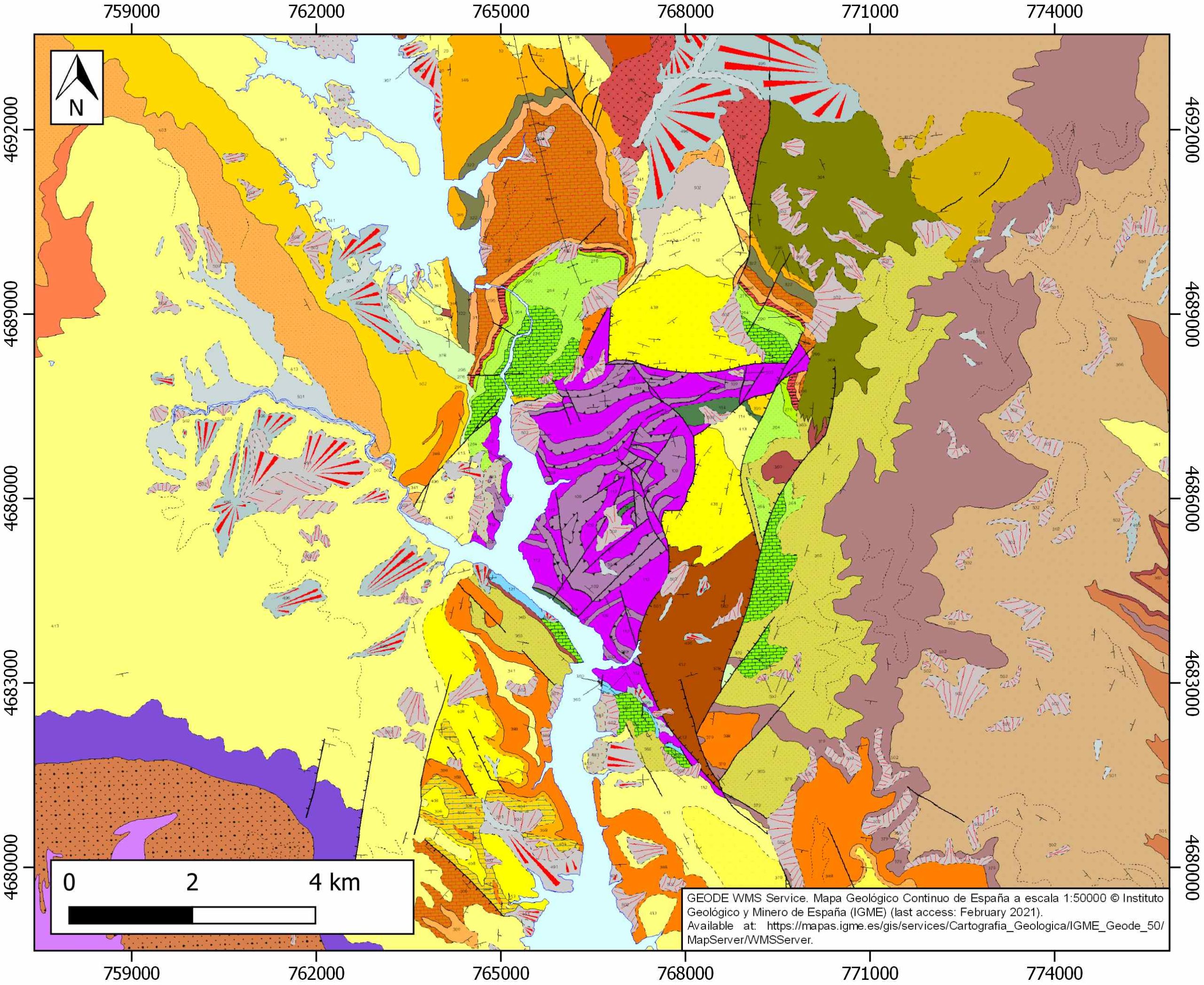
| Other Maps #1 (source) | Muñoz, J. A., Mencos, J., Roca, E., Carrera, N., Gratacós, O., Ferrer, O., Fernández, O., 2018. The structure of the South-Central-Pyrenean fold and thrust belt as constrained by subsurface data. Geologica Acta, 16(4), 439-460. [link] |
| Other Maps #2 (source) | Santolaria, P., Casas-Sainz, A. M., Soto, R., Casas, A., 2017. Gravity modelling to assess salt tectonics in the western end of the South Pyrenean Central Unit. Journal of the Geological Society, 174(2), 269-288. [link] |
| Other related references #1 | Falivene, O., Arbués, P., Ledo, J., Benjumea, B., Muñoz, J. A., Fernández, O., Martínez, S., 2010. Synthetic seismic models from outcrop-derived reservoir-scale three-dimensional facies models: The Eocene Ainsa turbidite system (southern Pyrenees). AAPG bulletin, 94(3), 317-343. [link] |
| Other related references #2 | Lanaja, J. M., R. Querol, A. Navarro, 1987. Contribución de la Exploración Petrolífera al Conocimiento de la Geología de España, pp. 1–465, Instituto Geológico y Minero de España, Madrid. [link] |
| Other related references #3 | Muñoz, J. A., Ferrer, O., Arbués, P., Beamud, E., Roca, E., Fernandez Bellon, O., 2014: Diapir Growth by Longitudinal Extension During the Development of a Thrust Salient in a Deepwater Fold and Thrust Belt: The Ainsa Oblique Zone in the Central Pyrenees. AAPG Annual Convention & Exhibition. |
| Other related references #4 | n.a. |
Well and Seismic Data
| UNIQUE_ID | 54 |
| Seismic survey name #1 | 0116A80S |
| Across structure? #1 | Y |
| Seismic profile ID (IGME) #1 | 5500 |
| Seismic profile code #1 | 8402 |
| Seismic profile name #1 | SP-25 |
| Seismic survey year #1 | 1980 |
| Data repository #1 | SIGEOF Data Catalogue (Private access section). ©Instituto Geológico y Minero de España (IGME). https://info.igme.es/SIGEOF/ |
| Length (km) #1 | 15.23 |
| Seismic survey name #2 | 10D1-SP |
| Across structure? #2 | Y |
| Seismic profile ID (IGME) #2 | 15463 |
| Seismic profile code #2 | 20203 |
| Seismic profile name #2 | SP-25 |
| Seismic survey year #2 | 1979 |
| Data repository #2 | SIGEOF Data Catalogue (Section available under request). ©Instituto Geológico y Minero de España (IGME). https://info.igme.es/SIGEOF/ |
| Length (km) #2 | 14.63 |
| Seismic survey name #3 | 0116A80U |
| Across structure? #3 | Y |
| Seismic profile ID (IGME) #3 | 5533 |
| Seismic profile code #3 | 8435 |
| Seismic profile name #3 | SP-25 |
| Seismic survey year #3 | 1980 |
| Data repository #3 | SIGEOF Data Catalogue (Private access section). ©Instituto Geológico y Minero de España (IGME). https://info.igme.es/SIGEOF/ |
| Length (km) #3 | 15.67 |
| Seismic survey name #4 | 0116A80U |
| Across structure? #4 | Y |
| Seismic profile ID (IGME) #4 | 4151 |
| Seismic profile code #4 | 5687 |
| Seismic profile name #4 | SP-25(1) |
| Seismic survey year #4 | 1980 |
| Data repository #4 | SIGEOF Data Catalogue (Private access section). ©Instituto Geológico y Minero de España (IGME). https://info.igme.es/SIGEOF/ |
| Length (km) #4 | 2.96 |
| Seismic survey name #5 | 10D1-SP |
| Across structure? #5 | Y |
| Seismic profile ID (IGME) #5 | 15462 |
| Seismic profile code #5 | 20202 |
| Seismic profile name #5 | SP-25-1 |
| Seismic survey year #5 | 1979 |
| Data repository #5 | SIGEOF Data Catalogue (Section available under request). ©Instituto Geológico y Minero de España (IGME). https://info.igme.es/SIGEOF/ |
| Length (km) #5 | 2.93 |
| Seismic survey name #6 | 0116A80G |
| Across structure? #6 | Y |
| Seismic profile ID (IGME) #6 | 5370 |
| Seismic profile code #6 | 7738 |
| Seismic profile name #6 | SP-25 |
| Seismic survey year #6 | 1980 |
| Data repository #6 | SIGEOF Data Catalogue (Private access section). ©Instituto Geológico y Minero de España (IGME). https://info.igme.es/SIGEOF/ |
| Length (km) #6 | 15.97 |
| Seismic survey name #7 | 10D1-SP |
| Across structure? #7 | N (within 3km) |
| Seismic profile ID (IGME) #7 | 15463 |
| Seismic profile code #7 | 20203 |
| Seismic profile name #7 | SP-25 |
| Seismic survey year #7 | 1979 |
| Data repository #7 | SIGEOF Data Catalogue (Section available under request). ©Instituto Geológico y Minero de España (IGME). https://info.igme.es/SIGEOF/ |
| Length (km) #7 | 14.63 |
| Seismic survey name #8 | 11D4-SP |
| Across structure? #8 | N (within 3km) |
| Seismic profile ID (IGME) #8 | 10323 |
| Seismic profile code #8 | 14951 |
| Seismic profile name #8 | SP-15 |
| Seismic survey year #8 | 1979 |
| Data repository #8 | SIGEOF Data Catalogue (Section available under request). ©Instituto Geológico y Minero de España (IGME). https://info.igme.es/SIGEOF/ |
| Length (km) #8 | 12.45 |
| Seismic survey name #9 | 10D1-SP |
| Across structure? #9 | N (within 3km) |
| Seismic profile ID (IGME) #9 | 15466 |
| Seismic profile code #9 | 20206 |
| Seismic profile name #9 | SP-17 |
| Seismic survey year #9 | 1979 |
| Data repository #9 | SIGEOF Data Catalogue (Section available under request). ©Instituto Geológico y Minero de España (IGME). https://info.igme.es/SIGEOF/ |
| Length (km) #9 | 18.32 |
| Seismic survey name #10 | 11D1-QUEROL-SP-84 |
| Across structure? #10 | N (within 3km) |
| Seismic profile ID (IGME) #10 | 10224 |
| Seismic profile code #10 | 14852 |
| Seismic profile name #10 | SP-84-17 |
| Seismic survey year #10 | 1984 |
| Data repository #10 | SIGEOF Data Catalogue (Section available under request). ©Instituto Geológico y Minero de España (IGME). https://info.igme.es/SIGEOF/ |
| Length (km) #10 | 11.31 |
| Seismic survey name #11 | 10D1-JAT |
| Across structure? #11 | N (within 3km) |
| Seismic profile ID (IGME) #11 | 10089 |
| Seismic profile code #11 | 14662 |
| Seismic profile name #11 | JAT-98 |
| Seismic survey year #11 | 1974 |
| Data repository #11 | SIGEOF Data Catalogue (Section available under request). ©Instituto Geológico y Minero de España (IGME). https://info.igme.es/SIGEOF/ |
| Length (km) #11 | 12.34 |
| Seismic survey name #12 | 10D1-SP |
| Across structure? #12 | N (within 3km) |
| Seismic profile ID (IGME) #12 | 15462 |
| Seismic profile code #12 | 20202 |
| Seismic profile name #12 | SP-25-1 |
| Seismic survey year #12 | 1979 |
| Data repository #12 | SIGEOF Data Catalogue (Section available under request). ©Instituto Geológico y Minero de España (IGME). https://info.igme.es/SIGEOF/ |
| Length (km) #12 | 2.93 |
| Seismic survey name #13 | 10D1-SP |
| Across structure? #13 | N (within 3km) |
| Seismic profile ID (IGME) #13 | 15454 |
| Seismic profile code #13 | 20194 |
| Seismic profile name #13 | SP-5 |
| Seismic survey year #13 | 1979 |
| Data repository #13 | SIGEOF Data Catalogue (Section available under request). ©Instituto Geológico y Minero de España (IGME). https://info.igme.es/SIGEOF/ |
| Length (km) #13 | 27.45 |
| Seismic survey name #14 | 10D1-SP |
| Across structure? #14 | N (within 3km) |
| Seismic profile ID (IGME) #14 | 15473 |
| Seismic profile code #14 | 20213 |
| Seismic profile name #14 | SP-1 |
| Seismic survey year #14 | 1979 |
| Data repository #14 | SIGEOF Data Catalogue (Section available under request). ©Instituto Geológico y Minero de España (IGME). https://info.igme.es/SIGEOF/ |
| Length (km) #14 | 15.35 |
| Seismic survey name #15 | 0116A80U |
| Across structure? #15 | N (within 3km) |
| Seismic profile ID (IGME) #15 | 5533 |
| Seismic profile code #15 | 8435 |
| Seismic profile name #15 | SP-25 |
| Seismic survey year #15 | 1980 |
| Data repository #15 | SIGEOF Data Catalogue (Private access section). ©Instituto Geológico y Minero de España (IGME). https://info.igme.es/SIGEOF/ |
| Length (km) #15 | 15.67 |
| Seismic survey name #16 | 0116A80S |
| Across structure? #16 | N (within 3km) |
| Seismic profile ID (IGME) #16 | 5500 |
| Seismic profile code #16 | 8402 |
| Seismic profile name #16 | SP-25 |
| Seismic survey year #16 | 1980 |
| Data repository #16 | SIGEOF Data Catalogue (Private access section). ©Instituto Geológico y Minero de España (IGME). https://info.igme.es/SIGEOF/ |
| Length (km) #16 | 15.23 |
| Seismic survey name #17 | 0116A80S |
| Across structure? #17 | N (within 3km) |
| Seismic profile ID (IGME) #17 | 5495 |
| Seismic profile code #17 | 8397 |
| Seismic profile name #17 | SP-17 |
| Seismic survey year #17 | 1980 |
| Data repository #17 | SIGEOF Data Catalogue (Private access section). ©Instituto Geológico y Minero de España (IGME). https://info.igme.es/SIGEOF/ |
| Length (km) #17 | 18.75 |
| Seismic survey name #18 | 11D1-ND |
| Across structure? #18 | N (within 3km) |
| Seismic profile ID (IGME) #18 | 10217 |
| Seismic profile code #18 | 14845 |
| Seismic profile name #18 | ND-102 |
| Seismic survey year #18 | 1962 |
| Data repository #18 | SIGEOF Data Catalogue (Private access section). ©Instituto Geológico y Minero de España (IGME). https://info.igme.es/SIGEOF/ |
| Length (km) #18 | 0.77 |
| Seismic survey name #19 | 0116A80U |
| Across structure? #19 | N (within 3km) |
| Seismic profile ID (IGME) #19 | 5529 |
| Seismic profile code #19 | 8431 |
| Seismic profile name #19 | SP-17 |
| Seismic survey year #19 | 1980 |
| Data repository #19 | SIGEOF Data Catalogue (Private access section). ©Instituto Geológico y Minero de España (IGME). https://info.igme.es/SIGEOF/ |
| Length (km) #19 | 19.58 |
| Seismic survey name #20 | 0355A84S |
| Across structure? #20 | N (within 3km) |
| Seismic profile ID (IGME) #20 | 5418 |
| Seismic profile code #20 | 7802 |
| Seismic profile name #20 | SP-84-17 |
| Seismic survey year #20 | 1984 |
| Data repository #20 | SIGEOF Data Catalogue (Private access section). ©Instituto Geológico y Minero de España (IGME). https://info.igme.es/SIGEOF/ |
| Length (km) #20 | 11.09 |
| Seismic survey name #21 | 0116A80U |
| Across structure? #21 | N (within 3km) |
| Seismic profile ID (IGME) #21 | 4151 |
| Seismic profile code #21 | 5687 |
| Seismic profile name #21 | SP-25(1) |
| Seismic survey year #21 | 1980 |
| Data repository #21 | SIGEOF Data Catalogue (Private access section). ©Instituto Geológico y Minero de España (IGME). https://info.igme.es/SIGEOF/ |
| Length (km) #21 | 2.96 |
| Borehole name #1 | PANILLO-EJEP |
| Company #1 | CONFEDERACION HIDROGRAFICA DEL EBRO |
| Traget #1 | HYDROGEOLOGY |
| Across structure? #1 | N (within 5 km) |
| Borehole name #2 | |
| Company #2 | |
| Traget #2 | |
| Across structure? #2 | |
| Borehole name #3 | |
| Company #3 | |
| Traget #3 | |
| Across structure? #3 | |
| Borehole name #4 | |
| Company #4 | |
| Traget #4 | |
| Across structure? #4 | |
| Borehole name #5 | |
| Company #5 | |
| Traget #5 | |
| Across structure? #5 | |
| Borehole name #6 | |
| Company #6 | |
| Traget #6 | |
| Across structure? #6 | |
| Borehole name #7 | |
| Company #7 | |
| Traget #7 | |
| Across structure? #7 | |
| Borehole name #8 | |
| Company #8 | |
| Traget #8 | |
| Across structure? #8 | |
| Borehole name #9 | |
| Company #9 | |
| Traget #9 | |
| Across structure? #9 | |
| Borehole name #10 | |
| Company #10 | |
| Traget #10 | |
| Across structure? #10 | |
| Borehole name #11 | |
| Company #11 | |
| Traget #11 | |
| Across structure? #11 | |
| Borehole name #12 | |
| Company #12 | |
| Traget #12 | |
| Across structure? #12 | |
| Borehole name #13 | |
| Company #13 | |
| Traget #13 | |
| Across structure? #13 | |
| Borehole name #14 | |
| Company #14 | |
| Traget #14 | |
| Across structure? #14 | |
| Borehole name #15 | |
| Company #15 | |
| Traget #15 | |
| Across structure? #15 |
Geographical Data (EPSG:4326 - WGS 84)
| UNIQUE_ID | 54 |
| X Centroid (Structure shape) | 0.234086 |
| Y Centroid (Structure shape) | 0.234086 |
| Xmin (Structure shape) | 0.207234 |
| Xmax (Structure shape) | 0.277056 |
| Ymin (Structure shape) | 42.236116 |
| Ymax (Structure shape) | 42.314976 |
| Xmin seismic line #1 | 0.163483 |
| Xmax seismic line #1 | 0.327847 |
| Ymin seismic line #1 | 42.285110 |
| Ymax seismic line #1 | 42.311806 |
| Xmin seismic line #2 | 0.159032 |
| Xmax seismic line #2 | 0.319410 |
| Ymin seismic line #2 | 42.282761 |
| Ymax seismic line #2 | 42.309921 |
| Xmin seismic line #3 | 0.162483 |
| Xmax seismic line #3 | 0.328153 |
| Ymin seismic line #3 | 42.282528 |
| Ymax seismic line #3 | 42.311585 |
| Xmin seismic line #4 | 0.217068 |
| Xmax seismic line #4 | 0.247318 |
| Ymin seismic line #4 | 42.280250 |
| Ymax seismic line #4 | 42.292335 |
| Xmin seismic line #5 | 0.216080 |
| Xmax seismic line #5 | 0.245772 |
| Ymin seismic line #5 | 42.282029 |
| Ymax seismic line #5 | 42.294042 |
| Xmin seismic line #6 | 0.162483 |
| Xmax seismic line #6 | 0.328153 |
| Ymin seismic line #6 | 42.282528 |
| Ymax seismic line #6 | 42.311642 |
| Xmin seismic line #7 | 0.159032 |
| Xmax seismic line #7 | 0.319410 |
| Ymin seismic line #7 | 42.282761 |
| Ymax seismic line #7 | 42.309921 |
| Xmin seismic line #8 | 0.302007 |
| Xmax seismic line #8 | 0.444141 |
| Ymin seismic line #8 | 42.255356 |
| Ymax seismic line #8 | 42.289300 |
| Xmin seismic line #9 | -0.005786 |
| Xmax seismic line #9 | 0.193282 |
| Ymin seismic line #9 | 42.265010 |
| Ymax seismic line #9 | 42.317023 |
| Xmin seismic line #10 | 0.263295 |
| Xmax seismic line #10 | 0.330382 |
| Ymin seismic line #10 | 42.335020 |
| Ymax seismic line #10 | 42.423783 |
| Xmin seismic line #11 | 0.217987 |
| Xmax seismic line #11 | 0.237938 |
| Ymin seismic line #11 | 42.337324 |
| Ymax seismic line #11 | 42.445665 |
| Xmin seismic line #12 | 0.216080 |
| Xmax seismic line #12 | 0.245772 |
| Ymin seismic line #12 | 42.282029 |
| Ymax seismic line #12 | 42.294042 |
| Xmin seismic line #13 | 0.244493 |
| Xmax seismic line #13 | 0.552631 |
| Ymin seismic line #13 | 42.174241 |
| Ymax seismic line #13 | 42.254695 |
| Xmin seismic line #14 | 0.012580 |
| Xmax seismic line #14 | 0.192028 |
| Ymin seismic line #14 | 42.277002 |
| Ymax seismic line #14 | 42.307133 |
| Xmin seismic line #15 | 0.162483 |
| Xmax seismic line #15 | 0.328153 |
| Ymin seismic line #15 | 42.282528 |
| Ymax seismic line #15 | 42.311585 |
| Xmin seismic line #16 | 0.163483 |
| Xmax seismic line #16 | 0.327847 |
| Ymin seismic line #16 | 42.285110 |
| Ymax seismic line #16 | 42.311806 |
| Xmin seismic line #17 | -0.002162 |
| Xmax seismic line #17 | 0.199901 |
| Ymin seismic line #17 | 42.267779 |
| Ymax seismic line #17 | 42.318642 |
| Xmin seismic line #18 | 0.300744 |
| Xmax seismic line #18 | 0.310051 |
| Ymin seismic line #18 | 42.304853 |
| Ymax seismic line #18 | 42.305266 |
| Xmin seismic line #19 | -0.003773 |
| Xmax seismic line #19 | 0.201928 |
| Ymin seismic line #19 | 42.267833 |
| Ymax seismic line #19 | 42.320142 |
| Xmin seismic line #20 | 0.264041 |
| Xmax seismic line #20 | 0.328597 |
| Ymin seismic line #20 | 42.335557 |
| Ymax seismic line #20 | 42.420395 |
| Xmin seismic line #21 | 0.217068 |
| Xmax seismic line #21 | 0.247318 |
| Ymin seismic line #21 | 42.280250 |
| Ymax seismic line #21 | 42.292335 |
| X borehole #1 | 0.305579 |
| Y borehole #1 | 42.251096 |
| X borehole #2 | |
| Y borehole #2 | |
| X borehole #3 | |
| Y borehole #3 | |
| X borehole #4 | |
| Y borehole #4 | |
| X borehole #5 | |
| Y borehole #5 | |
| X borehole #6 | |
| Y borehole #6 | |
| X borehole #7 | |
| Y borehole #7 | |
| X borehole #8 | |
| Y borehole #8 | |
| X borehole #9 | |
| Y borehole #9 | |
| X borehole #10 | |
| Y borehole #10 | |
| X borehole #11 | |
| Y borehole #11 | |
| X borehole #12 | |
| Y borehole #12 | |
| X borehole #13 | |
| Y borehole #13 | |
| X borehole #14 | |
| Y borehole #14 | |
| X borehole #15 | |
| Y borehole #15 |

