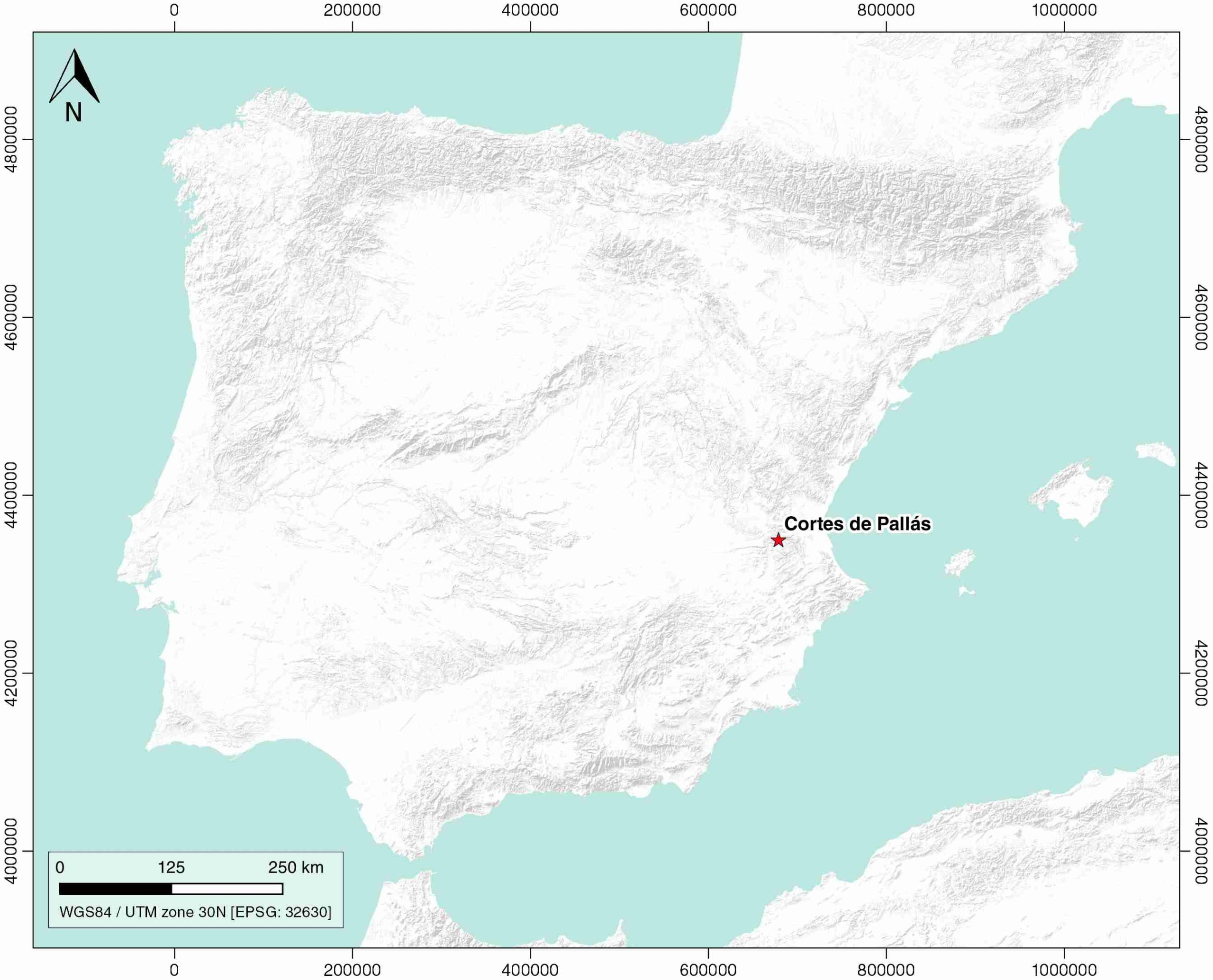
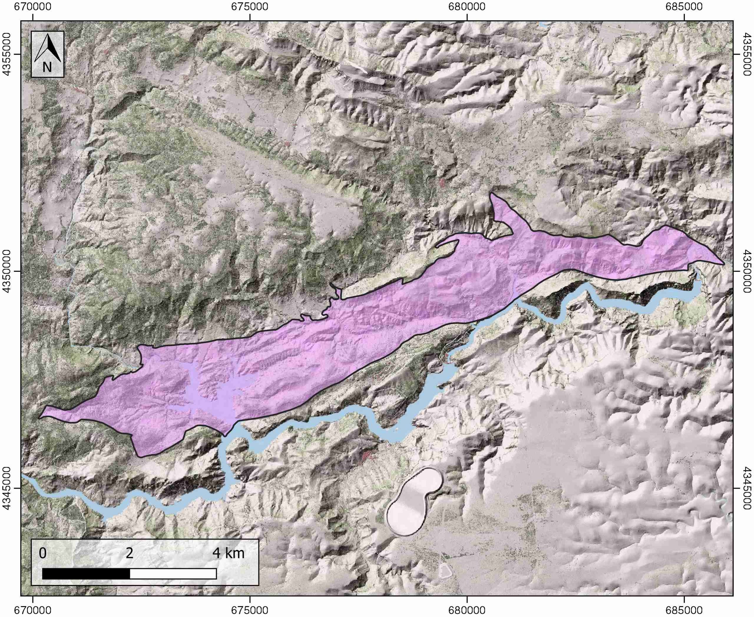
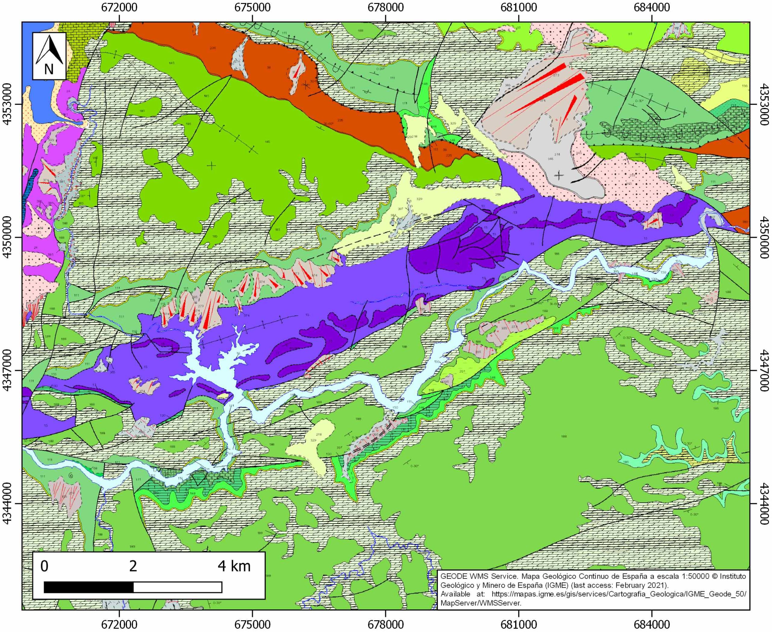
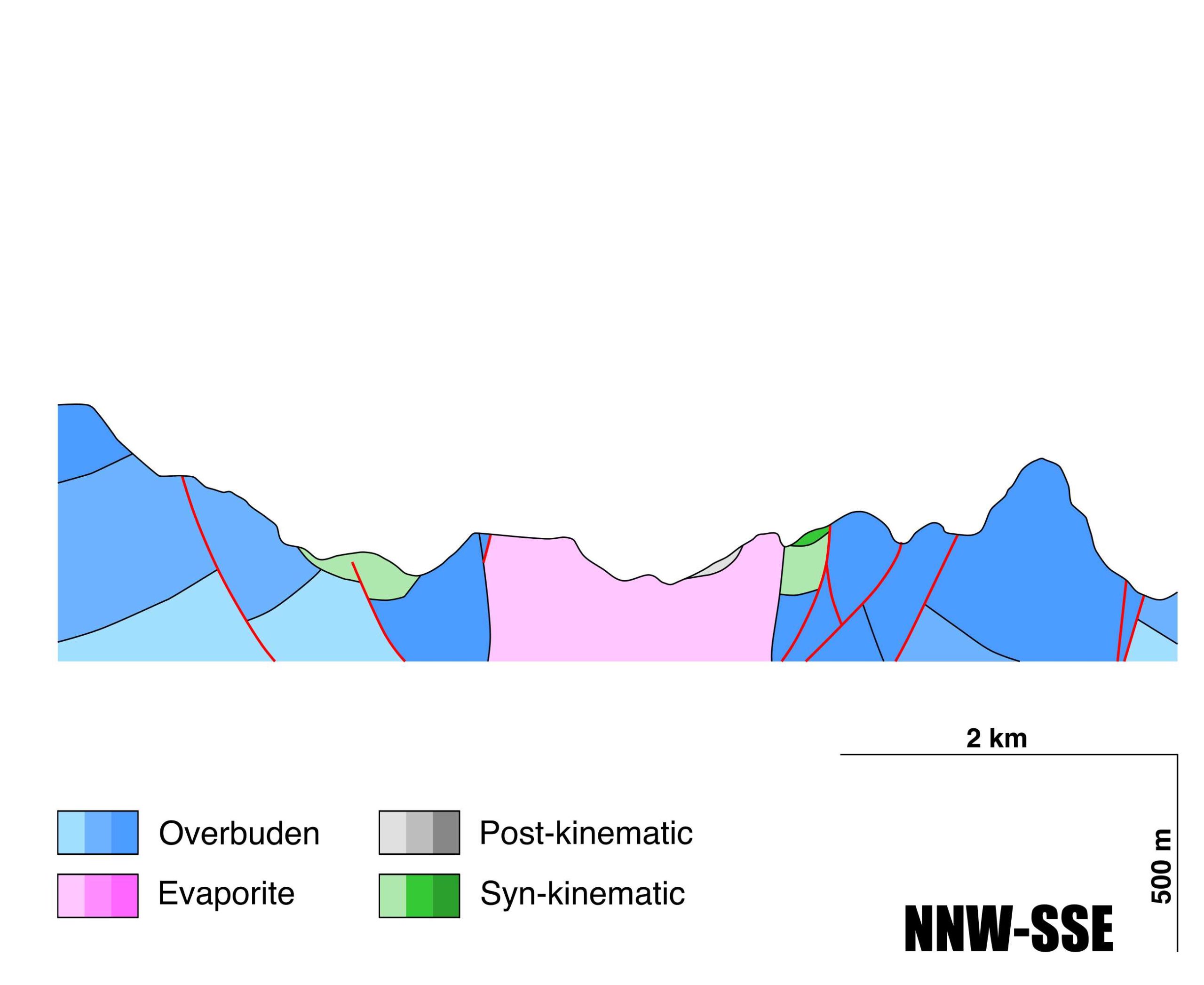
Cortes de Pallàs
ID #048
General Information
| Structure type | Evaporite Diapir |
| Deformed/Undeformed | Deformed |
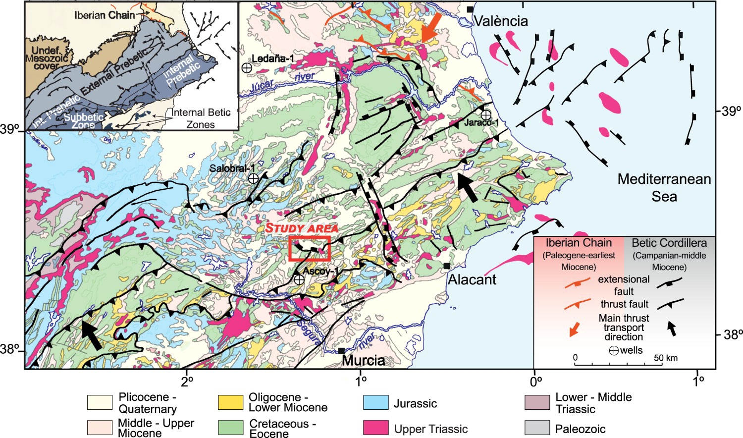
| Geological Setting | Betic system, Pre-Betic cordillera |
| Outcropping/buried | Outcropping |
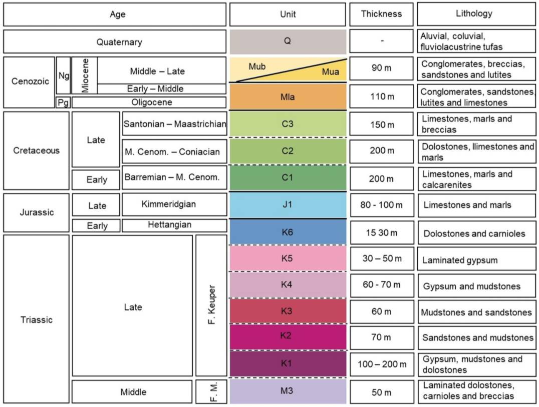
| Evaporite unit/s name | Jarafuel, Manuel, Cofrentes, Quesa, Ayora and Imón Fms. |
| Evaporite unit/s age | Carnian-Rhaetian (Upper Triassic) |
| Evaporite unit/s origin | Marine |
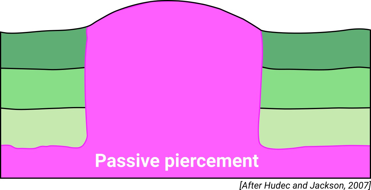
| Classif. (Hudec and Jackson, 2009) | Passive piercement |
| Classif. (Jackson and Talbot, 1986) | Salt wall |
| Age of evaporite flow or deformation (when deformed) | Miocene to Pliocene, Oligocene to Miocene |
| Other comments | Also known as "Dos Aguas" or "Gabriel-Júcar". |
Generic Data
| Unique ID | 48 |
| Name | Cortes de Pallàs (Dos Aguas, Gabriel-Júcar, Cortes de Pallàs Graben) |
| Structure type | Evaporite diapir |
| Deformed/Undeformed | Deformed |
| Buried/Outcropping | Outcropping |
| Geological setting | Betic System |
| Geological Regional Setting | Pre-Betic Cordillera (Valencian domain) |
| Evaporite unit/s name | Jarafuel, Manuel, Cofrentes, Quesa, Ayora and Imón Fms. |
| Evaporite unit/s age | Carnian-Rhaetian (Upper Triassic) |
| Evaporite unit/s era | Mesozoic |
| Evaporite unit/s origin | Marine |
| Evaporite unit/s composition | Gypsum-Mudstone-Dolostone-Sandstone |
| Post-kinematic unit/s (or post-evaporite units when evaporites are undeformed) | Quaternary (alluvial and colluvial detrital deposits) |
| Post-kinematic unit/s age (or post-evaporite units when evaporites are undeformed) | Pleistocene-Holocene |
| Classification (Hudec and Jackson, 2009) | Passive piercement |
| Classification (Jackson and Talbot, 1986) | Salt wall |
| Mining activity? | N |
| Mining activity start | |
| Mining activity end | |
| Mining galleries? | |
| Mining products | |
| Mining sub-products | |
| Evaporite flow? | Y |
| Age of evaporite flow | Oligocene – Early Miocene (early stage), Middle Miocene (compressional closure) and Late Miocene – Pliocene (reactivation late stage) |
| Flow or deformation triggering mechanisms | Main Prebetic rifting event (early stage), intra-Miocene contractional stage with the thrusting of the Mesozoic overburden above the Lower Miocene unit (compressional closure) and extensional phase described at the eastern Prebetics during Tortonian–Pliocene times (reactivation late stage) |
| Flow-linked structures? | Y |
| Halokinetic structures | Normal high-angle faults / thrust faults / joints / thickness variations / progressive unconformities |
| Post-evaporite and pre-kinematic unit/s (overbuden) | Kimmeridgian (Loriguilla Fm., rhythmic alternation of sandstones and marls) ; Barremian-Middle Cenomanian (Caroig, Sácaras, Alpuente and Chera Fms., limestones, marls and calcarenites) ; Middle Cenomanian-Coniacian (Alatoz, Villa de Ves, Casas de Medina, Ciudad Encantada and Alarcón Fms., dolostones, doloarenites, dolomitic marls and marls) ; Santonian – Maastrichtian (Utiel and Sierra Perenxisa Fms, marine and continental limestones and marls) |
| Syn-kinematic unit/s | Oligocene – Lower/Middle Miocene (Conglomerates, breccias, sandstones, sands and silts, limestones and marls) / Tortonian – Pliocene (utites, sands, sandstones and conglomerates |
| Available seismic profiles | |
| Available boreholes | |
| Additional comments | – |
Mining Data
| UNIQUE_ID | 48 |
| Minning exploitations within <2km? | N |
| Historical/Active | |
| Exploitation name #1 | |
| Exploitation ID (Spanish National Mining Cadastre) #1 | |
| Municipality #1 | |
| Province #1 | |
| Company #1 | |
| Main minning Products #1 | |
| Exploitation name #2 | |
| Exploitation ID (Spanish National Mining Cadastre) #2 | |
| Municipality #2 | |
| Province #2 | |
| Company #2 | |
| Main minning Products #2 | |
| Exploitation name #3 | |
| Exploitation ID (Spanish National Mining Cadastre) #3 | |
| Municipality #3 | |
| Province #3 | |
| Company #3 | |
| Main minning Products #3 |
Quantitative Data
| UNIQUE_ID | 48 |
| Outcropping area (km2) | 22.5628 |
| Horizontal intersection area (km2) (when buried) | Not buried |
| Depth of intersection area (km2) (when buried) | Not buried |
| Max. Width (Km) | 4.5606695 |
| Max. Length (Km) | 16.1870066 |
| Max. Evaporites thickness (km) | 0.8 |
| Max. Deformation age (Ma) | 30 |
| Min. Deformation age (Ma) | 3 |
| Deformation stages | 3 |
Reference Data
| UNIQUE_ID | 48 |
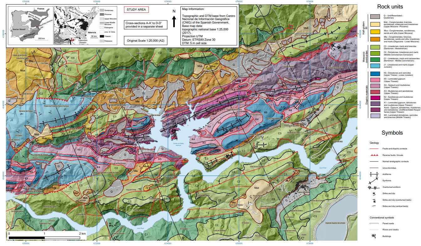
| Section source | Navarro-Carrasco, Ó., Meléndez-Hevia, I., 2020. Geology and evolution of the Cortes de Pallás diapir (Eastern Iberia). Journal of Maps, 16(2), 625-637. [link] |
| Well / Borehole availability #1 | De Torres, T., Sánchez, A., 1990. Espesores de las Facies Keuper en la Rama Castellana de la Cordillera Ibérica y en el Dominio Prebético. In F. Ortí & J. M. Salvany (Eds.): Formaciones evaporíticas de la Cuenca del Ebro y cadenas periféricas y de la zona de Levante (pp. 212–218). ENRESA – Universitat de Barcelona (Estudi 6). [link] |
| Well / Borehole availability #2 | Pérez-López, A., Solé de Porta, N., Ortí, F., 1996. Facies carbonato-evaporiticas del Trías superior y tránsito al Líás en el Levante espanol: nuevas precisiones estratigráficas. Cuadernos de geología ibérica, 20, 245-270. [link] |
| Available data (Stratigraphy) #1 | Pérez-López, A., Solé de Porta, N., Ortí, F., 1996. Facies carbonato-evaporiticas del Trías superior y tránsito al Líás en el Levante espanol: nuevas precisiones estratigráficas. Cuadernos de geología ibérica, 20, 245-270. [link] |
| Available data (Stratigraphy) #2 | Navarro-Carrasco, Ó., Meléndez-Hevia, I., 2020. Geology and evolution of the Cortes de Pallás diapir (Eastern Iberia). Journal of Maps, 16(2), 625-637. [link] |
| Available data (Stratigraphy) #3 | Gutiérrez, F., Sevil, J., Silva, P. G., Roca, E., Escosa, F., 2019. Geomorphic and stratigraphic evidence of Quaternary diapiric activity enhanced by fluvial incision. Navarrés salt wall and graben system, SE Spain. Geomorphology, 342, 176-195. [link] |
| Available data (Stratigraphy) #4 | del Olmo, W. M., Motis, K., Martín, D., 2015. El papel del diapirismo de la sal Triásica en la estructuración del Prebético (SE de España). Revista de la Sociedad Geológica de España, 28(1), 3-24. [link] |
| Available data (Stratigraphy) #5 | Ortí, F., Pérez-López, A., Salvany, J. M., 2017. Triassic evaporites of Iberia: Sedimentological and palaeogeographical implications for the western Neotethys evolution during the Middle Triassic–Earliest Jurassic. Palaeogeography, palaeoclimatology, palaeoecology, 471, 157-180. [link] |
| Available data (Stratigraphy) #6 | López-Gómez, J., Alonso-Azcárate, J., Arche, A., Arribas, J., Barrenechea, J. F., Borruel-Abadía, V., Bourquin, S., Cadenas, P., Cuevas, J., De La Horra, R., Bienvenido, J., Escudero-Mozo, M.J., Fernández-Viejo, G. (…) & Díez, J. B., 2019. Permian-Triassic Rifting Stage. In: Quesada C., Oliveira J. (eds) The Geology of Iberia: A Geodynamic Approach. Regional Geology Reviews. Springer, Cham. [link] |
| Regional Stratigraphy | Navarro-Carrasco, Ó., Meléndez-Hevia, I., 2020. Geology and evolution of the Cortes de Pallás diapir (Eastern Iberia). Journal of Maps, 16(2), 625-637. [link] |
| Seismic data availability #1 | n.a. |
| Seismic data availability #2 | n.a. |
| Seismic data availability #3 | n.a. |
| Available data (Structure) #1 | Navarro-Carrasco, Ó., Meléndez-Hevia, I., 2020. Geology and evolution of the Cortes de Pallás diapir (Eastern Iberia). Journal of Maps, 16(2), 625-637. [link] |
| Available data (Structure) #2 | Santisteban, C. D., Saiz, J., Ruiz Sánchez, F. J., Bello, D, 1990. Tectónica y sedimentación en el margen oeste del «rift» terciario del valle de Ayora-Cofrentes (Valencia). Geogaceta, 8, 44-47. [link] |
| Available data (Structure) #3 | del Olmo, W. M., Motis, K., Martín, D., 2015. El papel del diapirismo de la sal Triásica en la estructuración del Prebético (SE de España). Revista de la Sociedad Geológica de España, 28(1), 3-24. [link] |
| Available data (Structure) #4 | Roca, E., Sans, M., Koyi, H. A., 2006. Polyphase deformation of diapiric areas in models and in the eastern Prebetics (Spain). AAPG bulletin, 90(1), 115-136. [link] |
| Available data (Structure) #5 | Gutiérrez, F., Sevil, J., Silva, P. G., Roca, E., Escosa, F., 2019. Geomorphic and stratigraphic evidence of Quaternary diapiric activity enhanced by fluvial incision. Navarrés salt wall and graben system, SE Spain. Geomorphology, 342, 176-195. [link] |
| Available data (Structure) #6 | Roca, E., Beamud, E., Rubinat, M., Soto, R., Ferrer, O., 2013. Paleomagnetic and inner diapiric structural constraints on the kinematic evolution of a salt-wall: The Bicorb-Quesa and northern Navarrés salt-wall segments case (Prebetic Zone, SE Iberia). Journal of Structural Geology, 52, 80-95. [link] |
| Available data (Analogue modelling) #1 | n.a. |
| Available data (Analogue modelling) #2 | n.a. |
| Available data (Analogue modelling) #3 | n.a. |
| Available data (Gravimetry – Tomography) #1 | Castaño-Fernández, S., Carbó-Gorosabel, A., 1995. Los afloramientos triásicos de la zona de confluencia de las Cordilleras Ibérica y Bética. Aportes de la gravimetría a su interpretación. Cuadernos de geología ibérica, (19), 235-248. [link] |
| Available data (Gravimetry – Tomography) #2 | Rubinat-Cabanas, M., 2012. Basement fault influence on the Bicorb-Quesa Salt Wall kinematics, insights from Magnetotelluric and Paleomagnetic techniques on Salt Tectonics [Ph.D. thesis]: Universitat de Barcelona, Barcelona, 169pp. [link] |
| Available data (Gravimetry – Tomography) #3 | Ayala, C., Bohoyo, F., Maestro, A., Reguera, M. I., Torne, M., Rubio, F., Fernández, M., García-Lobón, J. L., 2016. Updated Bouguer anomalies of the Iberian Peninsula: a new perspective to interpret the regional geology. Journal of Maps, 12(5), 1089-1092. [link] |
| Available data (Geochemistry) #1 | Cuairán, J. B., Inglès, M., Cabo, F. O., 1987. Observaciones sobre mineralogía y geoquímica de lutitas del Keuper de Valencia. Cuadernos de Geología Ibérica, 11, 363-384. [link] |
| Available data (Geochemistry) #2 | Ortí, F., García-Veigas, J., Rossell, L., Jurado, M. J., Utrilla, R., 1996. Formaciones salinas de las cuencas triásicas en la Península Ibérica: Caracterización Petrológica y Geoquímica. Cuadernos de Geología Ibérica, 20, 13-35. [link] |
| Available data (Geochemistry) #3 | n.a. |
| Available data (Geochemistry) #4 | n.a. |
| Available data (Petrophysics) #1 | Roca, E., Beamud, E., Rubinat, M., Soto, R., Ferrer, O., 2013. Paleomagnetic and inner diapiric structural constraints on the kinematic evolution of a salt-wall: The Bicorb-Quesa and northern Navarrés salt-wall segments case (Prebetic Zone, SE Iberia). Journal of Structural Geology, 52, 80-95. [link] |
| Available data (Petrophysics) #2 | Soto, R., Beamud, E., Oliva-Urcia, B., Roca, E., Rubinat, M., Villalaín, J. J., 2014. Applicability of magnetic fabrics in rocks associated with the emplacement of salt structures (the Bicorb–Quesa and Navarrés salt walls, Prebetics, SE Spain). Tectonophysics, 629, 319-334. [link] |
| IGME Geological Map (MAGNA50) Sheet number | 745-Jalance. [link] |
| Other Maps #1 (source) | Escosa, F. O., Ferrer, O., Roca, E., 2018. Geology of the Eastern Prebetic Zone at the Jumilla region (SE Iberia). Journal of Maps, 14(2), 77-86. [link] |
| Other Maps #2 (source) | Navarro-Carrasco, Ó., Meléndez-Hevia, I., 2020. Geology and evolution of the Cortes de Pallás diapir (Eastern Iberia). Journal of Maps, 16(2), 625-637. [link] |
| Other related references #1 | Santisteban, C., Benlloch, M. M., 2005. Los depósitos con facies Muschelkalk (Formación Dolomías y calizas de Cañete) del anticlinal de Jalance (Valencia). Geotemas (Madrid), (8), 147-150. [link] |
| Other related references #2 | Roca, E., Anadón, P., Utrilla, R., Vázquez, A., 1996. Rise, closure and reactivation of the Bicorb–Quesa evaporite diapir, eastern Prebetics, Spain. Journal of the Geological Society, 153(2), 311-321. [link] |
| Other related references #3 | Ortí-Cabo, F., 1974. El Keuper del Levante español. Estudios Geológicos, 30. [link] |
| Other related references #4 | n.a. |
Well and Seismic Data
| UNIQUE_ID | 48 |
| Seismic survey name #1 | |
| Across structure? #1 | |
| Seismic profile ID (IGME) #1 | |
| Seismic profile code #1 | |
| Seismic profile name #1 | |
| Seismic survey year #1 | |
| Data repository #1 | |
| Length (km) #1 | |
| Seismic survey name #2 | |
| Across structure? #2 | |
| Seismic profile ID (IGME) #2 | |
| Seismic profile code #2 | |
| Seismic profile name #2 | |
| Seismic survey year #2 | |
| Data repository #2 | |
| Length (km) #2 | |
| Seismic survey name #3 | |
| Across structure? #3 | |
| Seismic profile ID (IGME) #3 | |
| Seismic profile code #3 | |
| Seismic profile name #3 | |
| Seismic survey year #3 | |
| Data repository #3 | |
| Length (km) #3 | |
| Seismic survey name #4 | |
| Across structure? #4 | |
| Seismic profile ID (IGME) #4 | |
| Seismic profile code #4 | |
| Seismic profile name #4 | |
| Seismic survey year #4 | |
| Data repository #4 | |
| Length (km) #4 | |
| Seismic survey name #5 | |
| Across structure? #5 | |
| Seismic profile ID (IGME) #5 | |
| Seismic profile code #5 | |
| Seismic profile name #5 | |
| Seismic survey year #5 | |
| Data repository #5 | |
| Length (km) #5 | |
| Seismic survey name #6 | |
| Across structure? #6 | |
| Seismic profile ID (IGME) #6 | |
| Seismic profile code #6 | |
| Seismic profile name #6 | |
| Seismic survey year #6 | |
| Data repository #6 | |
| Length (km) #6 | |
| Seismic survey name #7 | |
| Across structure? #7 | |
| Seismic profile ID (IGME) #7 | |
| Seismic profile code #7 | |
| Seismic profile name #7 | |
| Seismic survey year #7 | |
| Data repository #7 | |
| Length (km) #7 | |
| Seismic survey name #8 | |
| Across structure? #8 | |
| Seismic profile ID (IGME) #8 | |
| Seismic profile code #8 | |
| Seismic profile name #8 | |
| Seismic survey year #8 | |
| Data repository #8 | |
| Length (km) #8 | |
| Seismic survey name #9 | |
| Across structure? #9 | |
| Seismic profile ID (IGME) #9 | |
| Seismic profile code #9 | |
| Seismic profile name #9 | |
| Seismic survey year #9 | |
| Data repository #9 | |
| Length (km) #9 | |
| Seismic survey name #10 | |
| Across structure? #10 | |
| Seismic profile ID (IGME) #10 | |
| Seismic profile code #10 | |
| Seismic profile name #10 | |
| Seismic survey year #10 | |
| Data repository #10 | |
| Length (km) #10 | |
| Seismic survey name #11 | |
| Across structure? #11 | |
| Seismic profile ID (IGME) #11 | |
| Seismic profile code #11 | |
| Seismic profile name #11 | |
| Seismic survey year #11 | |
| Data repository #11 | |
| Length (km) #11 | |
| Seismic survey name #12 | |
| Across structure? #12 | |
| Seismic profile ID (IGME) #12 | |
| Seismic profile code #12 | |
| Seismic profile name #12 | |
| Seismic survey year #12 | |
| Data repository #12 | |
| Length (km) #12 | |
| Seismic survey name #13 | |
| Across structure? #13 | |
| Seismic profile ID (IGME) #13 | |
| Seismic profile code #13 | |
| Seismic profile name #13 | |
| Seismic survey year #13 | |
| Data repository #13 | |
| Length (km) #13 | |
| Seismic survey name #14 | |
| Across structure? #14 | |
| Seismic profile ID (IGME) #14 | |
| Seismic profile code #14 | |
| Seismic profile name #14 | |
| Seismic survey year #14 | |
| Data repository #14 | |
| Length (km) #14 | |
| Seismic survey name #15 | |
| Across structure? #15 | |
| Seismic profile ID (IGME) #15 | |
| Seismic profile code #15 | |
| Seismic profile name #15 | |
| Seismic survey year #15 | |
| Data repository #15 | |
| Length (km) #15 | |
| Seismic survey name #16 | |
| Across structure? #16 | |
| Seismic profile ID (IGME) #16 | |
| Seismic profile code #16 | |
| Seismic profile name #16 | |
| Seismic survey year #16 | |
| Data repository #16 | |
| Length (km) #16 | |
| Seismic survey name #17 | |
| Across structure? #17 | |
| Seismic profile ID (IGME) #17 | |
| Seismic profile code #17 | |
| Seismic profile name #17 | |
| Seismic survey year #17 | |
| Data repository #17 | |
| Length (km) #17 | |
| Seismic survey name #18 | |
| Across structure? #18 | |
| Seismic profile ID (IGME) #18 | |
| Seismic profile code #18 | |
| Seismic profile name #18 | |
| Seismic survey year #18 | |
| Data repository #18 | |
| Length (km) #18 | |
| Seismic survey name #19 | |
| Across structure? #19 | |
| Seismic profile ID (IGME) #19 | |
| Seismic profile code #19 | |
| Seismic profile name #19 | |
| Seismic survey year #19 | |
| Data repository #19 | |
| Length (km) #19 | |
| Seismic survey name #20 | |
| Across structure? #20 | |
| Seismic profile ID (IGME) #20 | |
| Seismic profile code #20 | |
| Seismic profile name #20 | |
| Seismic survey year #20 | |
| Data repository #20 | |
| Length (km) #20 | |
| Seismic survey name #21 | |
| Across structure? #21 | |
| Seismic profile ID (IGME) #21 | |
| Seismic profile code #21 | |
| Seismic profile name #21 | |
| Seismic survey year #21 | |
| Data repository #21 | |
| Length (km) #21 | |
| Borehole name #1 | |
| Company #1 | |
| Traget #1 | |
| Across structure? #1 | |
| Borehole name #2 | |
| Company #2 | |
| Traget #2 | |
| Across structure? #2 | |
| Borehole name #3 | |
| Company #3 | |
| Traget #3 | |
| Across structure? #3 | |
| Borehole name #4 | |
| Company #4 | |
| Traget #4 | |
| Across structure? #4 | |
| Borehole name #5 | |
| Company #5 | |
| Traget #5 | |
| Across structure? #5 | |
| Borehole name #6 | |
| Company #6 | |
| Traget #6 | |
| Across structure? #6 | |
| Borehole name #7 | |
| Company #7 | |
| Traget #7 | |
| Across structure? #7 | |
| Borehole name #8 | |
| Company #8 | |
| Traget #8 | |
| Across structure? #8 | |
| Borehole name #9 | |
| Company #9 | |
| Traget #9 | |
| Across structure? #9 | |
| Borehole name #10 | |
| Company #10 | |
| Traget #10 | |
| Across structure? #10 | |
| Borehole name #11 | |
| Company #11 | |
| Traget #11 | |
| Across structure? #11 | |
| Borehole name #12 | |
| Company #12 | |
| Traget #12 | |
| Across structure? #12 | |
| Borehole name #13 | |
| Company #13 | |
| Traget #13 | |
| Across structure? #13 | |
| Borehole name #14 | |
| Company #14 | |
| Traget #14 | |
| Across structure? #14 | |
| Borehole name #15 | |
| Company #15 | |
| Traget #15 | |
| Across structure? #15 |
Geographical Data (EPSG:4326 - WGS 84)
| UNIQUE_ID | 48 |
| X Centroid (Structure shape) | -0.943034 |
| Y Centroid (Structure shape) | -0.943034 |
| Xmin (Structure shape) | -1.028404 |
| Xmax (Structure shape) | -0.844375 |
| Ymin (Structure shape) | 39.243549 |
| Ymax (Structure shape) | 39.296928 |
| Xmin seismic line #1 | |
| Xmax seismic line #1 | |
| Ymin seismic line #1 | |
| Ymax seismic line #1 | |
| Xmin seismic line #2 | |
| Xmax seismic line #2 | |
| Ymin seismic line #2 | |
| Ymax seismic line #2 | |
| Xmin seismic line #3 | |
| Xmax seismic line #3 | |
| Ymin seismic line #3 | |
| Ymax seismic line #3 | |
| Xmin seismic line #4 | |
| Xmax seismic line #4 | |
| Ymin seismic line #4 | |
| Ymax seismic line #4 | |
| Xmin seismic line #5 | |
| Xmax seismic line #5 | |
| Ymin seismic line #5 | |
| Ymax seismic line #5 | |
| Xmin seismic line #6 | |
| Xmax seismic line #6 | |
| Ymin seismic line #6 | |
| Ymax seismic line #6 | |
| Xmin seismic line #7 | |
| Xmax seismic line #7 | |
| Ymin seismic line #7 | |
| Ymax seismic line #7 | |
| Xmin seismic line #8 | |
| Xmax seismic line #8 | |
| Ymin seismic line #8 | |
| Ymax seismic line #8 | |
| Xmin seismic line #9 | |
| Xmax seismic line #9 | |
| Ymin seismic line #9 | |
| Ymax seismic line #9 | |
| Xmin seismic line #10 | |
| Xmax seismic line #10 | |
| Ymin seismic line #10 | |
| Ymax seismic line #10 | |
| Xmin seismic line #11 | |
| Xmax seismic line #11 | |
| Ymin seismic line #11 | |
| Ymax seismic line #11 | |
| Xmin seismic line #12 | |
| Xmax seismic line #12 | |
| Ymin seismic line #12 | |
| Ymax seismic line #12 | |
| Xmin seismic line #13 | |
| Xmax seismic line #13 | |
| Ymin seismic line #13 | |
| Ymax seismic line #13 | |
| Xmin seismic line #14 | |
| Xmax seismic line #14 | |
| Ymin seismic line #14 | |
| Ymax seismic line #14 | |
| Xmin seismic line #15 | |
| Xmax seismic line #15 | |
| Ymin seismic line #15 | |
| Ymax seismic line #15 | |
| Xmin seismic line #16 | |
| Xmax seismic line #16 | |
| Ymin seismic line #16 | |
| Ymax seismic line #16 | |
| Xmin seismic line #17 | |
| Xmax seismic line #17 | |
| Ymin seismic line #17 | |
| Ymax seismic line #17 | |
| Xmin seismic line #18 | |
| Xmax seismic line #18 | |
| Ymin seismic line #18 | |
| Ymax seismic line #18 | |
| Xmin seismic line #19 | |
| Xmax seismic line #19 | |
| Ymin seismic line #19 | |
| Ymax seismic line #19 | |
| Xmin seismic line #20 | |
| Xmax seismic line #20 | |
| Ymin seismic line #20 | |
| Ymax seismic line #20 | |
| Xmin seismic line #21 | |
| Xmax seismic line #21 | |
| Ymin seismic line #21 | |
| Ymax seismic line #21 | |
| X borehole #1 | |
| Y borehole #1 | |
| X borehole #2 | |
| Y borehole #2 | |
| X borehole #3 | |
| Y borehole #3 | |
| X borehole #4 | |
| Y borehole #4 | |
| X borehole #5 | |
| Y borehole #5 | |
| X borehole #6 | |
| Y borehole #6 | |
| X borehole #7 | |
| Y borehole #7 | |
| X borehole #8 | |
| Y borehole #8 | |
| X borehole #9 | |
| Y borehole #9 | |
| X borehole #10 | |
| Y borehole #10 | |
| X borehole #11 | |
| Y borehole #11 | |
| X borehole #12 | |
| Y borehole #12 | |
| X borehole #13 | |
| Y borehole #13 | |
| X borehole #14 | |
| Y borehole #14 | |
| X borehole #15 | |
| Y borehole #15 |

