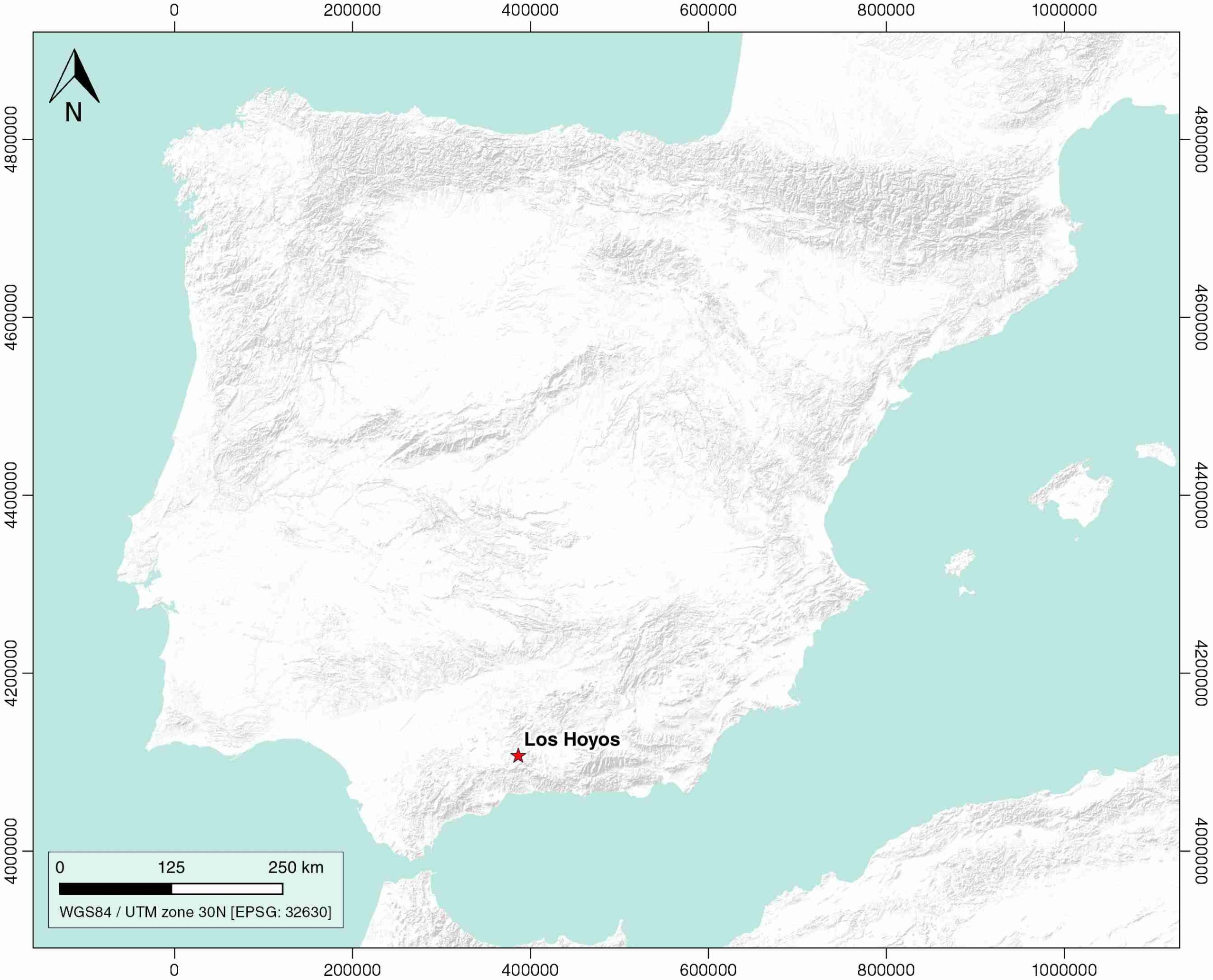
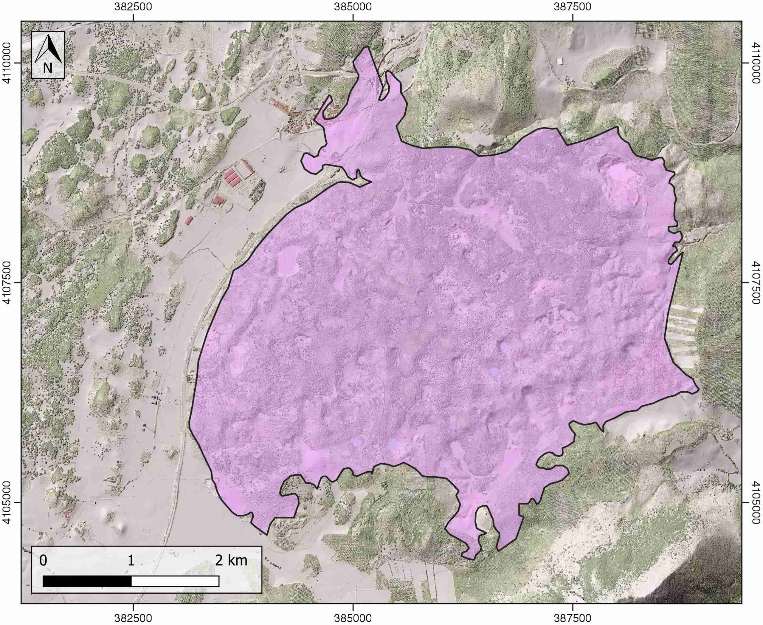
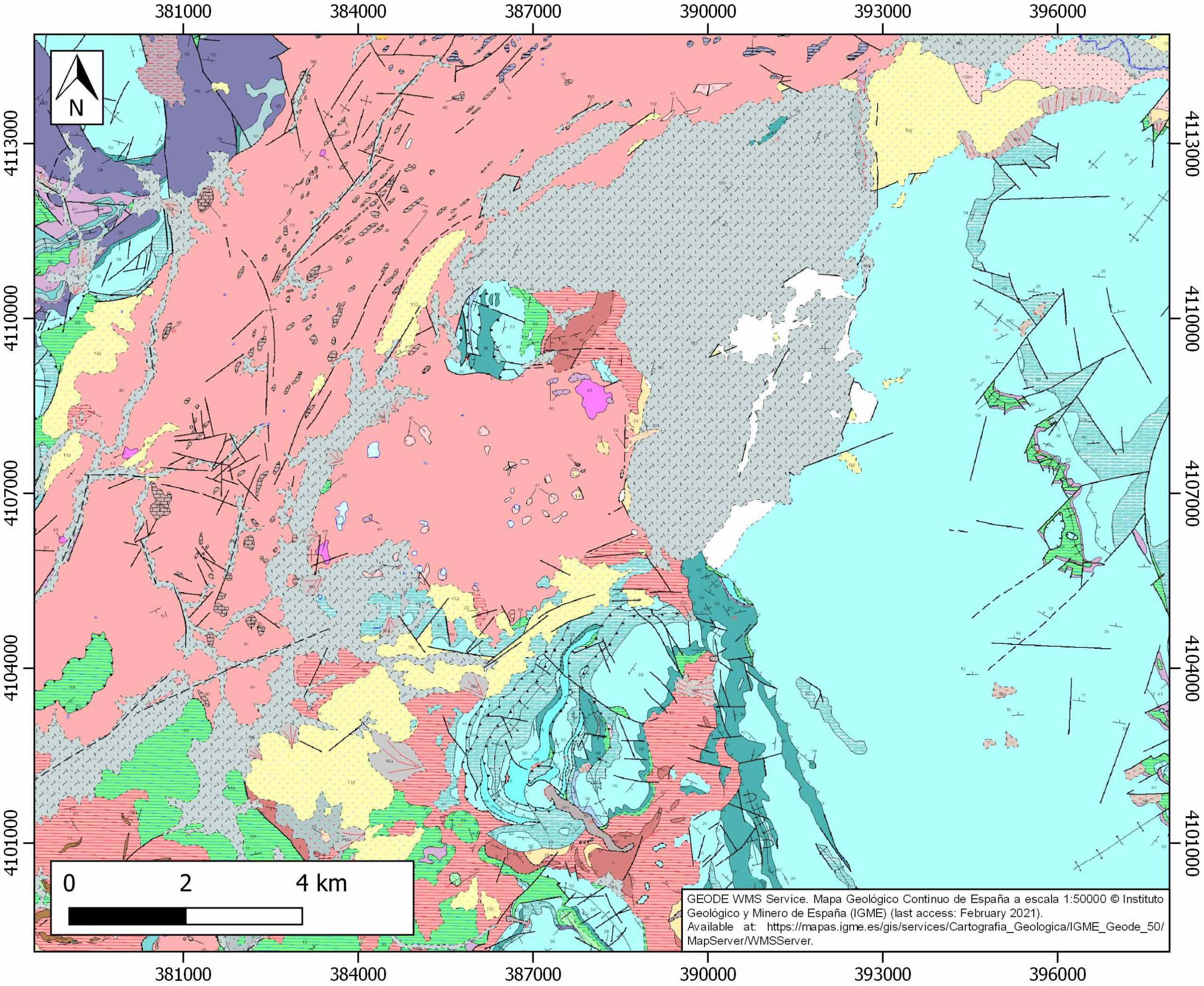
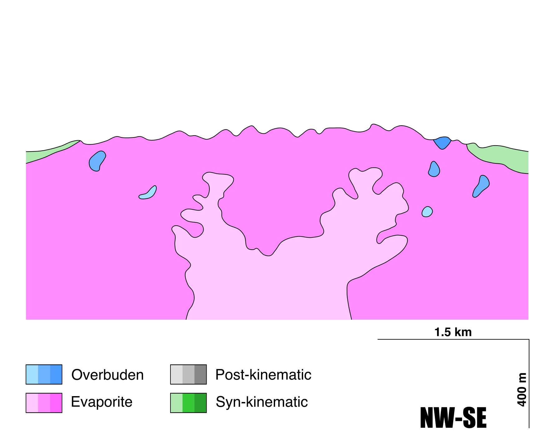
General Information
| Structure type | Evaporite Diapir |
| Deformed/Undeformed | Deformed |
| Geological Setting | Betic system, Pre-Betic cordillera |
| Outcropping/buried | Outcropping |
| Evaporite unit/s name | Keuper facies |
| Evaporite unit/s age | Carnian-Rhaetian (Upper Triassic) |
| Evaporite unit/s origin | Marine |
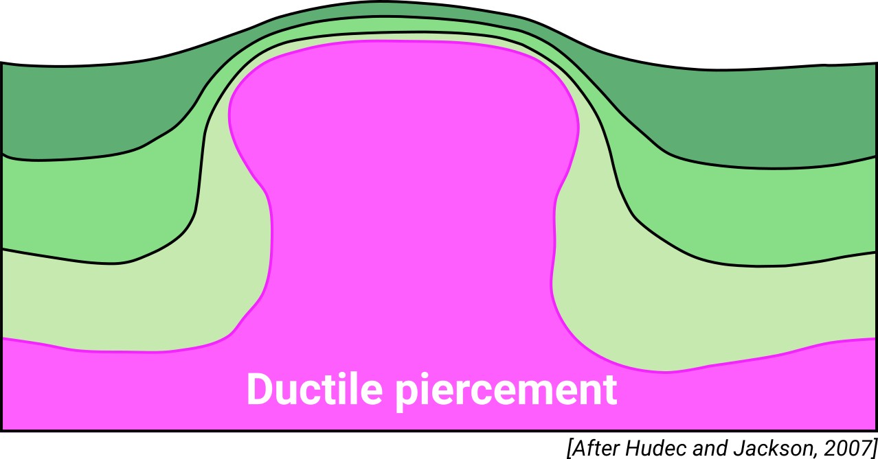
| Classif. (Hudec and Jackson, 2009) | Ductile piercement |
| Classif. (Jackson and Talbot, 1986) | Salt stock |
| Age of evaporite flow or deformation (when deformed) | Quaternary / Active now(?) |
| Other comments | The onset of diapirism is unknown. |
Generic Data
| Unique ID | 12 |
| Name | Del Hoyo (Los Hoyos) |
| Structure type | Evaporite diapir |
| Deformed/Undeformed | Deformed |
| Buried/Outcropping | Outcropping |
| Geological setting | Betic System |
| Geological Regional Setting | Pre-Betic Cordillera |
| Evaporite unit/s name | Keuper facies |
| Evaporite unit/s age | Carnian-Rhaetian (Upper Triassic) |
| Evaporite unit/s era | Mesozoic |
| Evaporite unit/s origin | Marine |
| Evaporite unit/s composition | Gypsum-Halite-Anhydrite-Claystone |
| Post-kinematic unit/s (or post-evaporite units when evaporites are undeformed) | Quaternary (alluvial and colluvial detrital deposits) |
| Post-kinematic unit/s age (or post-evaporite units when evaporites are undeformed) | Holocene |
| Classification (Hudec and Jackson, 2009) | Ductile piercement |
| Classification (Jackson and Talbot, 1986) | Salt stock |
| Mining activity? | Y |
| Mining activity start | – |
| Mining activity end | – |
| Mining galleries? | – |
| Mining products | Gypsum |
| Mining sub-products | – |
| Evaporite flow? | Y |
| Age of evaporite flow | Active now |
| Flow or deformation triggering mechanisms | |
| Flow-linked structures? | Y |
| Halokinetic structures | Elevation and folding of the Plio-Quaternary (alluvial and colluvial detrital deposits) |
| Post-evaporite and pre-kinematic unit/s (overbuden) | Quaternary (alluvial and colluvial detrital deposits) |
| Syn-kinematic unit/s | |
| Available seismic profiles | |
| Available boreholes | |
| Additional comments | – |
Mining Data
| UNIQUE_ID | 12 |
| Minning exploitations within <2km? | Y |
| Historical/Active | Active |
| Exploitation name #1 | CARLOS DAVID |
| Exploitation ID (Spanish National Mining Cadastre) #1 | 230 |
| Municipality #1 | Archidona |
| Province #1 | MALAGA |
| Company #1 | SOCIEDAD FINANCIERA Y MINERA, S.A. |
| Main minning Products #1 | Gypsum |
| Exploitation name #2 | VIRGEN DE GRACIA |
| Exploitation ID (Spanish National Mining Cadastre) #2 | 30223 |
| Municipality #2 | Loja |
| Province #2 | GRANADA |
| Company #2 | YESOS LAS LAGUNAS, SA |
| Main minning Products #2 | Gypsum |
| Exploitation name #3 | |
| Exploitation ID (Spanish National Mining Cadastre) #3 | |
| Municipality #3 | |
| Province #3 | |
| Company #3 | |
| Main minning Products #3 |
Quantitative Data
| UNIQUE_ID | 12 |
| Outcropping area (km2) | 19.36262 |
| Horizontal intersection area (km2) (when buried) | Not buried |
| Depth of intersection area (km2) (when buried) | Not buried |
| Max. Width (Km) | 5.6 |
| Max. Length (Km) | 5.5 |
| Max. Evaporites thickness (km) | 0.9 |
| Max. Deformation age (Ma) | |
| Min. Deformation age (Ma) | Active |
| Deformation stages | 1 |
Reference Data
| UNIQUE_ID | 12 |
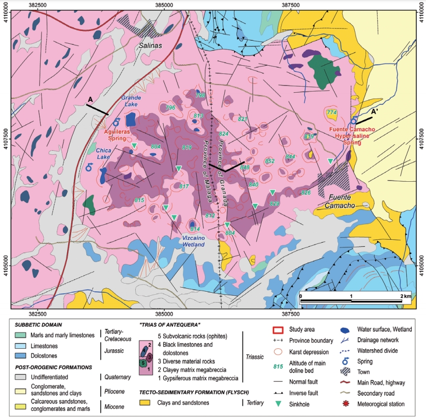
| Section source | Gil-Márquez, J. M., Mudarra, M., Andreo, B., Linares, L., Carrasco, F., & Benavente, J., 2016. Hydrogeological characterization of the Salinas-Los Hoyos evaporitic karst (Malaga province, S Spain) using topographic, hydrodynamic, hydrochemical and isotopic methods. Acta Carsologica, 45(2). [link] |
| Well / Borehole availability #1 | n.a. |
| Well / Borehole availability #2 | n.a. |
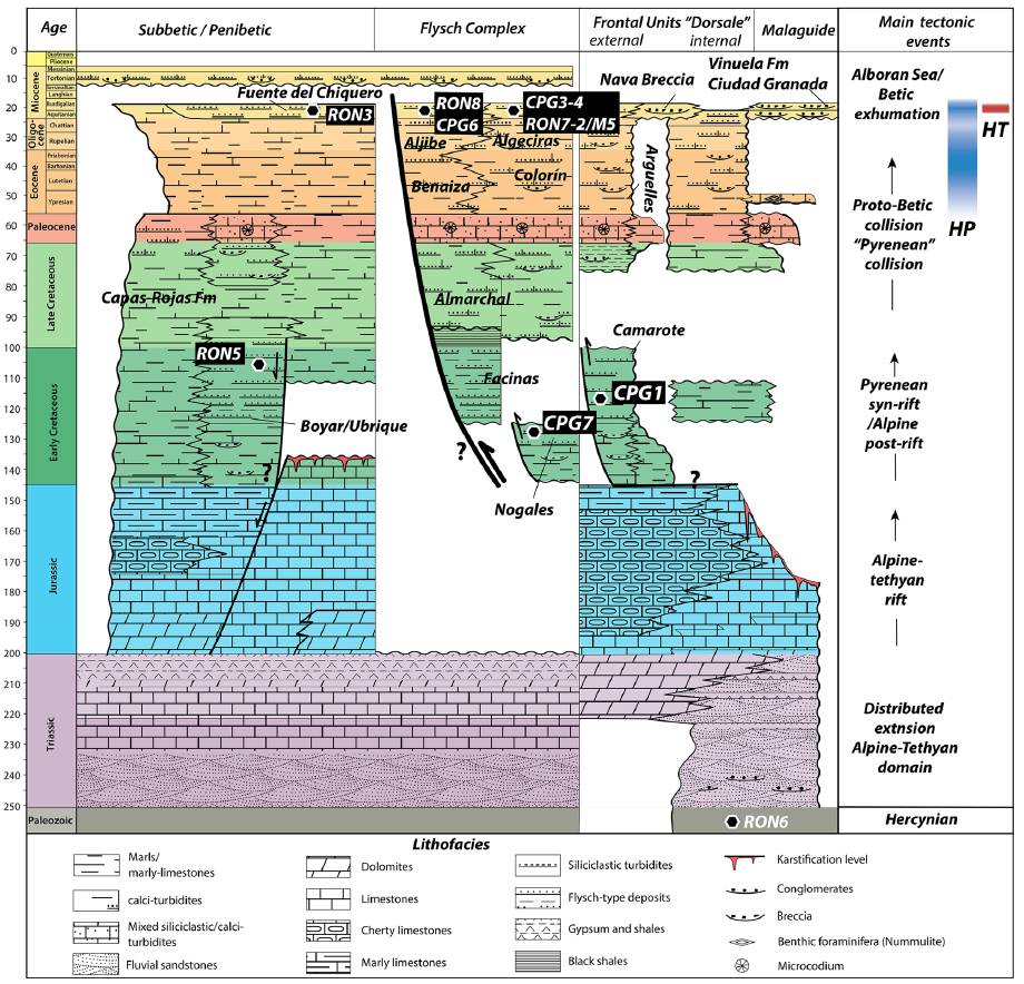
| Available data (Stratigraphy) #1 | Daudet, M., Mouthereau, F., Brichau, S., Crespo‐Blanc, A., Gautheron, C., Angrand, P., 2020. Tectono‐stratigraphic and thermal evolution of the western Betic flysch: implications for the geodynamics of South Iberian margin and Alboran Domain. Tectonics, 39(7), 6093. [link] |
| Available data (Stratigraphy) #2 | Calaforra, J.M., Pulido-Bosch, A., 1993. The hydrochemistry and morphology of the triassic gypsum in the Salinas-Fuente Camacho Area (Granada). In: Pulido-Bosch, A. (ed.) Some Spanish Karstic Aquifers. University of Granada, pp. 387–389, Granada. [link] |
| Available data (Stratigraphy) #3 | Peyre, Y., 1974. Géologie d’Antequera et de sa région: Cordillères Bétiques-Espagne, [Ph.D. thesis]: Institut national agronomique Paris-Grignon, 528 p. [link] |
| Available data (Stratigraphy) #4 | Carrasco, F., Durán, J.J., Calaforra, J.M., 2007. El Trías de Antequera. In: Durán, J.J. (ed) Atlas hidrogeológico de la provincia de Málaga. Instituto Geológico y Minero de España, Diputación de Málaga, pp. 206–210, Madrid. [link] |
| Available data (Stratigraphy) #5 | n.a. |
| Available data (Stratigraphy) #6 | n.a. |
| Regional Stratigraphy | Daudet, M., Mouthereau, F., Brichau, S., Crespo‐Blanc, A., Gautheron, C., Angrand, P., 2020. Tectono‐stratigraphic and thermal evolution of the western Betic flysch: implications for the geodynamics of South Iberian margin and Alboran Domain. Tectonics, 39(7), 6093. [link] |
| Seismic data availability #1 | n.a. |
| Seismic data availability #2 | n.a. |
| Seismic data availability #3 | n.a. |
| Available data (Structure) #1 | Rodríguez-Estrella, T., 1983: Neotectónica relacionada con las estructuras diapíricas en el Sureste de la Península Ibérica.- Tecniterrae, 51, 14–30. [link] |
| Available data (Structure) #2 | Pérez-López, A., Sanz de Galdeano, C., 1994. Tectónica de los materiales triásicos en el sector central de la Zona Subbética (Cordillera Bética). Revista de la Sociedad Geológica de España, 7, 141–153. [link] |
| Available data (Structure) #3 | Calaforra, J.M., Pulido-Bosch, A., 1993. The hydrochemistry and morphology of the triassic gypsum in the Salinas-Fuente Camacho Area (Granada). In: Pulido-Bosch, A. (ed.) Some Spanish Karstic Aquifers. University of Granada, pp. 387–389, Granada. [link] |
| Available data (Structure) #4 | Gil-Márquez, J. M., Mudarra, M., Andreo, B., Linares, L., Carrasco, F., & Benavente, J., 2016. Hydrogeological characterization of the Salinas-Los Hoyos evaporitic karst (Malaga province, S Spain) using topographic, hydrodynamic, hydrochemical and isotopic methods. Acta Carsologica, 45(2). [link] |
| Available data (Structure) #5 | Peyre, Y., 1974. Géologie d’Antequera et de sa région: Cordillères Bétiques-Espagne, [Ph.D. thesis]: Institut national agronomique Paris-Grignon, 528 p. [link] |
| Available data (Structure) #6 | n.a. |
| Available data (Analogue modelling) #1 | n.a. |
| Available data (Analogue modelling) #2 | n.a. |
| Available data (Analogue modelling) #3 | n.a. |
| Available data (Gravimetry – Tomography) #1 | Ayala, C., Bohoyo, F., Maestro, A., Reguera, M. I., Torne, M., Rubio, F., Fernández, M., García-Lobón, J. L., 2016. Updated Bouguer anomalies of the Iberian Peninsula: a new perspective to interpret the regional geology. Journal of Maps, 12(5), 1089-1092. [link] |
| Available data (Gravimetry – Tomography) #2 | n.a. |
| Available data (Gravimetry – Tomography) #3 | n.a. |
| Available data (Geochemistry) #1 | Gil-Márquez, J. M., Mudarra, M., Andreo, B., Linares, L., Carrasco, F., & Benavente, J., 2016. Hydrogeological characterization of the Salinas-Los Hoyos evaporitic karst (Malaga province, S Spain) using topographic, hydrodynamic, hydrochemical and isotopic methods. Acta Carsologica, 45(2). [link] |
| Available data (Geochemistry) #2 | Calaforra, J.M., Pulido-Bosch, A., 1993. The hydrochemistry and morphology of the triassic gypsum in the Salinas-Fuente Camacho Area (Granada). In: Pulido-Bosch, A. (ed.) Some Spanish Karstic Aquifers. University of Granada, pp. 387–389, Granada. [link] |
| Available data (Geochemistry) #3 | Ortí, F., García-Veigas, J., Rossell, L., Jurado, M. J., Utrilla, R., 1996. Formaciones salinas de las cuencas triásicas en la Península Ibérica: Caracterización Petrológica y Geoquímica. Cuadernos de Geología Ibérica, 20, 13-35. [link] |
| Available data (Geochemistry) #4 | n.a. |
| Available data (Petrophysics) #1 | n.a. |
| Available data (Petrophysics) #2 | n.a. |
| IGME Geological Map (MAGNA50) Sheet number | 1024-Archidona. [link] |
| Other Maps #1 (source) | Gil-Márquez, J. M., Mudarra, M., Andreo, B., Linares, L., Carrasco, F., & Benavente, J., 2016. Hydrogeological characterization of the Salinas-Los Hoyos evaporitic karst (Malaga province, S Spain) using topographic, hydrodynamic, hydrochemical and isotopic methods. Acta Carsologica, 45(2). [link] |
| Other Maps #2 (source) | Gil-Márquez, J. M., Mudarra, M., Andreo, B., Linares, L., Carrasco, F., & Benavente, J., 2016. Hydrogeological characterization of the Salinas-Los Hoyos evaporitic karst (Malaga province, S Spain) using topographic, hydrodynamic, hydrochemical and isotopic methods. Acta Carsologica, 45(2). [link] |
| Other related references #1 | Carrasco F., 1986. Contribución al conocimiento de la cuenca alta del río Guadalhorce. El medio físico. Hidrogeoquímica [PhD thesis]: University of Granada, pp. 435. [link] |
| Other related references #2 | Linares, L., 2008. Lagunas y humedales andaluces relacionados con surgencias. In: A. Castillo (ed.) Manantiales de Andalucía. Agencia Andaluza del Agua, Consejería de Medio Ambiente, Junta de Andalucía, pp.156–171, Sevilla. |
| Other related references #3 | Rodríguez-Rodríguez, M., Moral, F., Benavente, J., 2007. Hydro-morphological characteristics and hydrogeological functioning of a wetland system: A case study in southern Spain. Environmental Geology, 52, 1375–1386. [link] |
| Other related references #4 | n.a. |
Well and Seismic Data
| UNIQUE_ID | 12 |
| Seismic survey name #1 | |
| Across structure? #1 | |
| Seismic profile ID (IGME) #1 | |
| Seismic profile code #1 | |
| Seismic profile name #1 | |
| Seismic survey year #1 | |
| Data repository #1 | |
| Length (km) #1 | |
| Seismic survey name #2 | |
| Across structure? #2 | |
| Seismic profile ID (IGME) #2 | |
| Seismic profile code #2 | |
| Seismic profile name #2 | |
| Seismic survey year #2 | |
| Data repository #2 | |
| Length (km) #2 | |
| Seismic survey name #3 | |
| Across structure? #3 | |
| Seismic profile ID (IGME) #3 | |
| Seismic profile code #3 | |
| Seismic profile name #3 | |
| Seismic survey year #3 | |
| Data repository #3 | |
| Length (km) #3 | |
| Seismic survey name #4 | |
| Across structure? #4 | |
| Seismic profile ID (IGME) #4 | |
| Seismic profile code #4 | |
| Seismic profile name #4 | |
| Seismic survey year #4 | |
| Data repository #4 | |
| Length (km) #4 | |
| Seismic survey name #5 | |
| Across structure? #5 | |
| Seismic profile ID (IGME) #5 | |
| Seismic profile code #5 | |
| Seismic profile name #5 | |
| Seismic survey year #5 | |
| Data repository #5 | |
| Length (km) #5 | |
| Seismic survey name #6 | |
| Across structure? #6 | |
| Seismic profile ID (IGME) #6 | |
| Seismic profile code #6 | |
| Seismic profile name #6 | |
| Seismic survey year #6 | |
| Data repository #6 | |
| Length (km) #6 | |
| Seismic survey name #7 | |
| Across structure? #7 | |
| Seismic profile ID (IGME) #7 | |
| Seismic profile code #7 | |
| Seismic profile name #7 | |
| Seismic survey year #7 | |
| Data repository #7 | |
| Length (km) #7 | |
| Seismic survey name #8 | |
| Across structure? #8 | |
| Seismic profile ID (IGME) #8 | |
| Seismic profile code #8 | |
| Seismic profile name #8 | |
| Seismic survey year #8 | |
| Data repository #8 | |
| Length (km) #8 | |
| Seismic survey name #9 | |
| Across structure? #9 | |
| Seismic profile ID (IGME) #9 | |
| Seismic profile code #9 | |
| Seismic profile name #9 | |
| Seismic survey year #9 | |
| Data repository #9 | |
| Length (km) #9 | |
| Seismic survey name #10 | |
| Across structure? #10 | |
| Seismic profile ID (IGME) #10 | |
| Seismic profile code #10 | |
| Seismic profile name #10 | |
| Seismic survey year #10 | |
| Data repository #10 | |
| Length (km) #10 | |
| Seismic survey name #11 | |
| Across structure? #11 | |
| Seismic profile ID (IGME) #11 | |
| Seismic profile code #11 | |
| Seismic profile name #11 | |
| Seismic survey year #11 | |
| Data repository #11 | |
| Length (km) #11 | |
| Seismic survey name #12 | |
| Across structure? #12 | |
| Seismic profile ID (IGME) #12 | |
| Seismic profile code #12 | |
| Seismic profile name #12 | |
| Seismic survey year #12 | |
| Data repository #12 | |
| Length (km) #12 | |
| Seismic survey name #13 | |
| Across structure? #13 | |
| Seismic profile ID (IGME) #13 | |
| Seismic profile code #13 | |
| Seismic profile name #13 | |
| Seismic survey year #13 | |
| Data repository #13 | |
| Length (km) #13 | |
| Seismic survey name #14 | |
| Across structure? #14 | |
| Seismic profile ID (IGME) #14 | |
| Seismic profile code #14 | |
| Seismic profile name #14 | |
| Seismic survey year #14 | |
| Data repository #14 | |
| Length (km) #14 | |
| Seismic survey name #15 | |
| Across structure? #15 | |
| Seismic profile ID (IGME) #15 | |
| Seismic profile code #15 | |
| Seismic profile name #15 | |
| Seismic survey year #15 | |
| Data repository #15 | |
| Length (km) #15 | |
| Seismic survey name #16 | |
| Across structure? #16 | |
| Seismic profile ID (IGME) #16 | |
| Seismic profile code #16 | |
| Seismic profile name #16 | |
| Seismic survey year #16 | |
| Data repository #16 | |
| Length (km) #16 | |
| Seismic survey name #17 | |
| Across structure? #17 | |
| Seismic profile ID (IGME) #17 | |
| Seismic profile code #17 | |
| Seismic profile name #17 | |
| Seismic survey year #17 | |
| Data repository #17 | |
| Length (km) #17 | |
| Seismic survey name #18 | |
| Across structure? #18 | |
| Seismic profile ID (IGME) #18 | |
| Seismic profile code #18 | |
| Seismic profile name #18 | |
| Seismic survey year #18 | |
| Data repository #18 | |
| Length (km) #18 | |
| Seismic survey name #19 | |
| Across structure? #19 | |
| Seismic profile ID (IGME) #19 | |
| Seismic profile code #19 | |
| Seismic profile name #19 | |
| Seismic survey year #19 | |
| Data repository #19 | |
| Length (km) #19 | |
| Seismic survey name #20 | |
| Across structure? #20 | |
| Seismic profile ID (IGME) #20 | |
| Seismic profile code #20 | |
| Seismic profile name #20 | |
| Seismic survey year #20 | |
| Data repository #20 | |
| Length (km) #20 | |
| Seismic survey name #21 | |
| Across structure? #21 | |
| Seismic profile ID (IGME) #21 | |
| Seismic profile code #21 | |
| Seismic profile name #21 | |
| Seismic survey year #21 | |
| Data repository #21 | |
| Length (km) #21 | |
| Borehole name #1 | |
| Company #1 | |
| Traget #1 | |
| Across structure? #1 | |
| Borehole name #2 | |
| Company #2 | |
| Traget #2 | |
| Across structure? #2 | |
| Borehole name #3 | |
| Company #3 | |
| Traget #3 | |
| Across structure? #3 | |
| Borehole name #4 | |
| Company #4 | |
| Traget #4 | |
| Across structure? #4 | |
| Borehole name #5 | |
| Company #5 | |
| Traget #5 | |
| Across structure? #5 | |
| Borehole name #6 | |
| Company #6 | |
| Traget #6 | |
| Across structure? #6 | |
| Borehole name #7 | |
| Company #7 | |
| Traget #7 | |
| Across structure? #7 | |
| Borehole name #8 | |
| Company #8 | |
| Traget #8 | |
| Across structure? #8 | |
| Borehole name #9 | |
| Company #9 | |
| Traget #9 | |
| Across structure? #9 | |
| Borehole name #10 | |
| Company #10 | |
| Traget #10 | |
| Across structure? #10 | |
| Borehole name #11 | |
| Company #11 | |
| Traget #11 | |
| Across structure? #11 | |
| Borehole name #12 | |
| Company #12 | |
| Traget #12 | |
| Across structure? #12 | |
| Borehole name #13 | |
| Company #13 | |
| Traget #13 | |
| Across structure? #13 | |
| Borehole name #14 | |
| Company #14 | |
| Traget #14 | |
| Across structure? #14 | |
| Borehole name #15 | |
| Company #15 | |
| Traget #15 | |
| Across structure? #15 |
Geographical Data (EPSG:4326 - WGS 84)
| UNIQUE_ID | 12 |
| X Centroid (Structure shape) | -4.282989 |
| Y Centroid (Structure shape) | -4.282989 |
| Xmin (Structure shape) | -4.315001 |
| Xmax (Structure shape) | -4.249790 |
| Ymin (Structure shape) | 37.078517 |
| Ymax (Structure shape) | 37.131023 |
| Xmin seismic line #1 | |
| Xmax seismic line #1 | |
| Ymin seismic line #1 | |
| Ymax seismic line #1 | |
| Xmin seismic line #2 | |
| Xmax seismic line #2 | |
| Ymin seismic line #2 | |
| Ymax seismic line #2 | |
| Xmin seismic line #3 | |
| Xmax seismic line #3 | |
| Ymin seismic line #3 | |
| Ymax seismic line #3 | |
| Xmin seismic line #4 | |
| Xmax seismic line #4 | |
| Ymin seismic line #4 | |
| Ymax seismic line #4 | |
| Xmin seismic line #5 | |
| Xmax seismic line #5 | |
| Ymin seismic line #5 | |
| Ymax seismic line #5 | |
| Xmin seismic line #6 | |
| Xmax seismic line #6 | |
| Ymin seismic line #6 | |
| Ymax seismic line #6 | |
| Xmin seismic line #7 | |
| Xmax seismic line #7 | |
| Ymin seismic line #7 | |
| Ymax seismic line #7 | |
| Xmin seismic line #8 | |
| Xmax seismic line #8 | |
| Ymin seismic line #8 | |
| Ymax seismic line #8 | |
| Xmin seismic line #9 | |
| Xmax seismic line #9 | |
| Ymin seismic line #9 | |
| Ymax seismic line #9 | |
| Xmin seismic line #10 | |
| Xmax seismic line #10 | |
| Ymin seismic line #10 | |
| Ymax seismic line #10 | |
| Xmin seismic line #11 | |
| Xmax seismic line #11 | |
| Ymin seismic line #11 | |
| Ymax seismic line #11 | |
| Xmin seismic line #12 | |
| Xmax seismic line #12 | |
| Ymin seismic line #12 | |
| Ymax seismic line #12 | |
| Xmin seismic line #13 | |
| Xmax seismic line #13 | |
| Ymin seismic line #13 | |
| Ymax seismic line #13 | |
| Xmin seismic line #14 | |
| Xmax seismic line #14 | |
| Ymin seismic line #14 | |
| Ymax seismic line #14 | |
| Xmin seismic line #15 | |
| Xmax seismic line #15 | |
| Ymin seismic line #15 | |
| Ymax seismic line #15 | |
| Xmin seismic line #16 | |
| Xmax seismic line #16 | |
| Ymin seismic line #16 | |
| Ymax seismic line #16 | |
| Xmin seismic line #17 | |
| Xmax seismic line #17 | |
| Ymin seismic line #17 | |
| Ymax seismic line #17 | |
| Xmin seismic line #18 | |
| Xmax seismic line #18 | |
| Ymin seismic line #18 | |
| Ymax seismic line #18 | |
| Xmin seismic line #19 | |
| Xmax seismic line #19 | |
| Ymin seismic line #19 | |
| Ymax seismic line #19 | |
| Xmin seismic line #20 | |
| Xmax seismic line #20 | |
| Ymin seismic line #20 | |
| Ymax seismic line #20 | |
| Xmin seismic line #21 | |
| Xmax seismic line #21 | |
| Ymin seismic line #21 | |
| Ymax seismic line #21 | |
| X borehole #1 | |
| Y borehole #1 | |
| X borehole #2 | |
| Y borehole #2 | |
| X borehole #3 | |
| Y borehole #3 | |
| X borehole #4 | |
| Y borehole #4 | |
| X borehole #5 | |
| Y borehole #5 | |
| X borehole #6 | |
| Y borehole #6 | |
| X borehole #7 | |
| Y borehole #7 | |
| X borehole #8 | |
| Y borehole #8 | |
| X borehole #9 | |
| Y borehole #9 | |
| X borehole #10 | |
| Y borehole #10 | |
| X borehole #11 | |
| Y borehole #11 | |
| X borehole #12 | |
| Y borehole #12 | |
| X borehole #13 | |
| Y borehole #13 | |
| X borehole #14 | |
| Y borehole #14 | |
| X borehole #15 | |
| Y borehole #15 |

