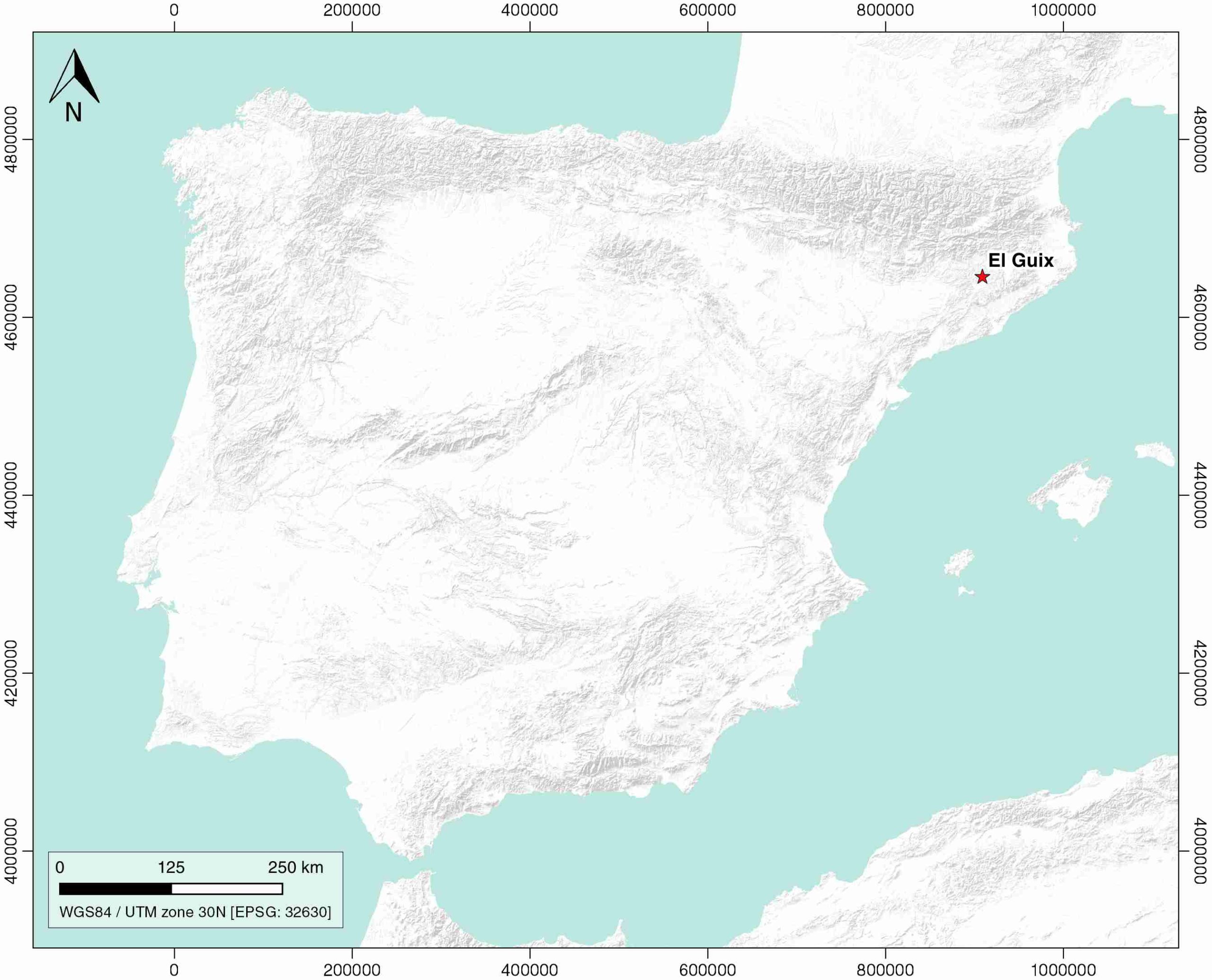
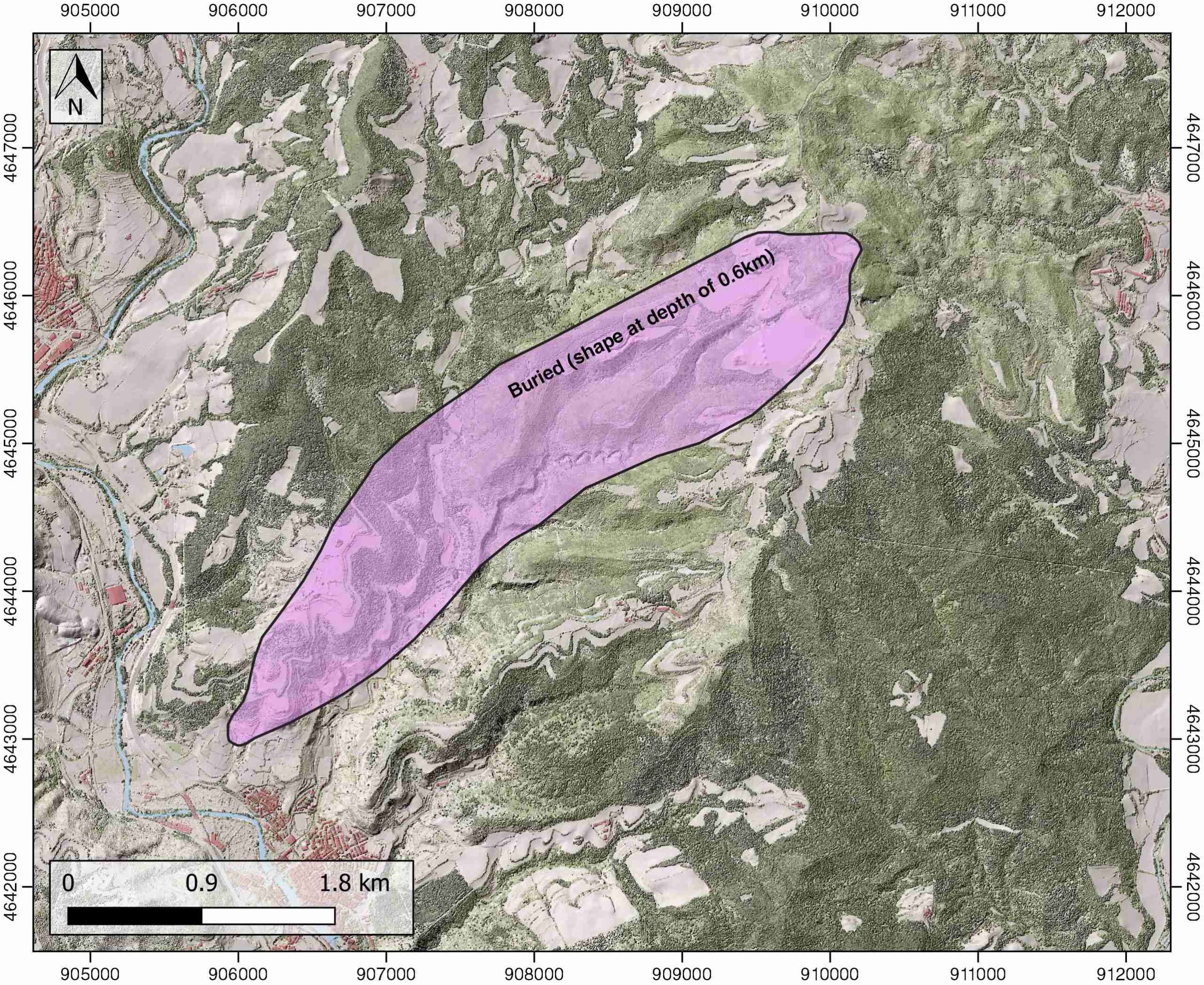
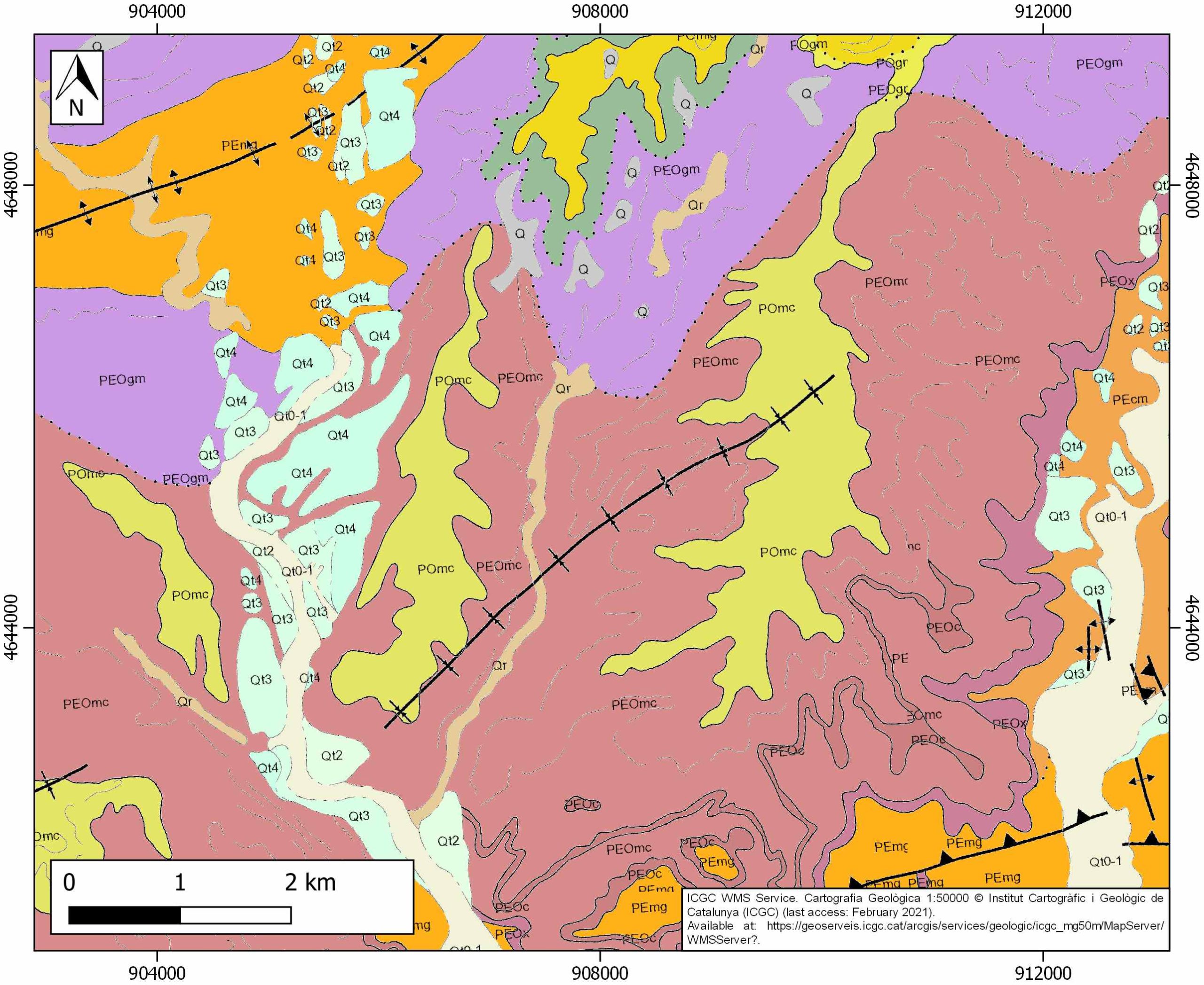
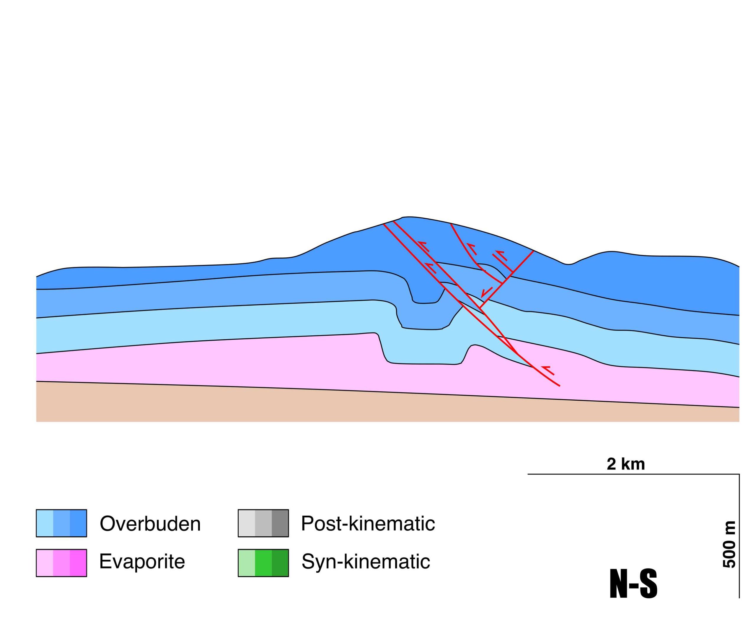
General Information
| Structure type | Evaporite-cored anticline |
| Deformed/Undeformed | Deformed |
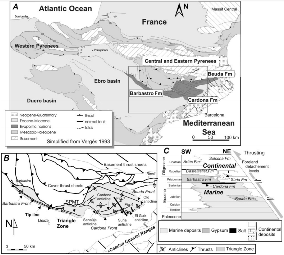
| Geological Setting | Catalan Potash sub-basin, Ebro foreland basin |
| Outcropping/buried | Buried |
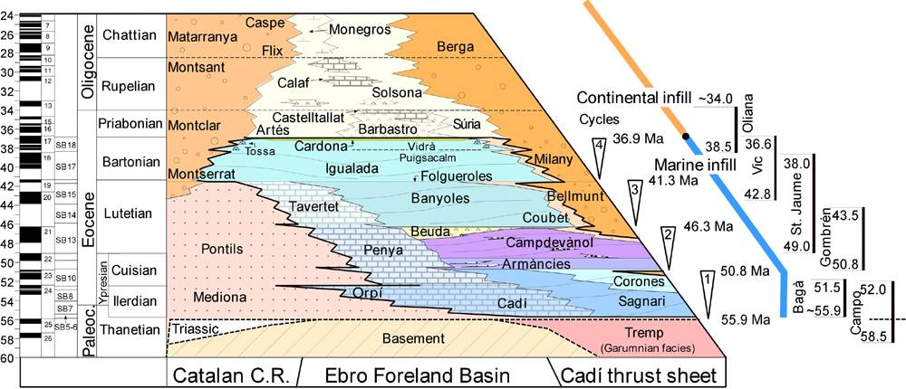
| Evaporite unit/s name | Cardona Fm. |
| Evaporite unit/s age | Priabonian (Eocene) |
| Evaporite unit/s origin | Marine |
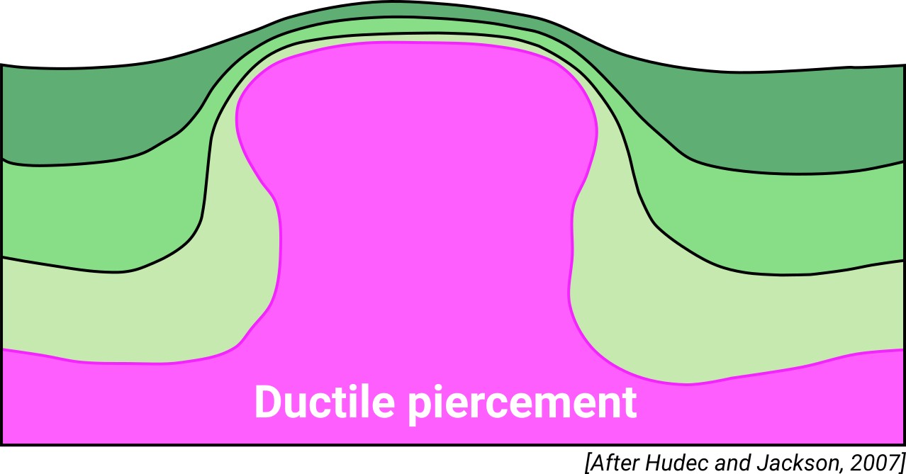
| Classif. (Hudec and Jackson, 2009) | Ductile piercement |
| Classif. (Jackson and Talbot, 1986) | Salt anticline |
| Age of evaporite flow or deformation (when deformed) | Lower Oligocene, Quaternary / Active now(?) |
| Other comments | Unprecise growth age of the Cardona, Suria and El Guix anticlines because of the absence of related syntectonic sediments. |
Generic Data
| Unique ID | 107 |
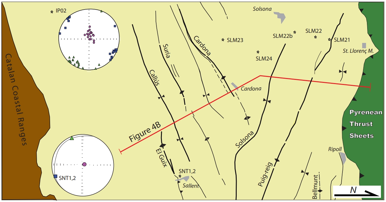
| Name | El Guix |
| Structure type | Evaporite-cored anticline |
| Deformed/Undeformed | Deformed |
| Buried/Outcropping | Buried |
| Geological setting | Ebro Basin |
| Geological Regional Setting | Catalan Potash sub-basin |
| Evaporite unit/s name | Cardona Fm. |
| Evaporite unit/s age | Priabonian (Eocene) |
| Evaporite unit/s era | Cenozoic |
| Evaporite unit/s origin | Marine |
| Evaporite unit/s composition | Halite-Anhydrite-Carnallite-Sylvite-Shale-Marlstones |
| Post-kinematic unit/s (or post-evaporite units when evaporites are undeformed) | Quaternary (alluvial and colluvial detrital deposits) |
| Post-kinematic unit/s age (or post-evaporite units when evaporites are undeformed) | Pleistocene-Holocene |
| Classification (Hudec and Jackson, 2009) | Ductile piercement |
| Classification (Jackson and Talbot, 1986) | Salt anticline |
| Mining activity? | Y |
| Mining activity start | Roman Empire |
| Mining activity end | Active |
| Mining galleries? | Y |
| Mining products | Gypsum |
| Mining sub-products | Halite |
| Evaporite flow? | Y |
| Age of evaporite flow | Lower Oligocene (early stage) ; Quaternary (reactivation stage) |
| Flow or deformation triggering mechanisms | Moderate folding of the overlying units (early stage) ; Quaternary fault activity (reactivation stage) |
| Flow-linked structures? | Y |
| Halokinetic structures | Triangle zone development / thrust faults |
| Post-evaporite and pre-kinematic unit/s (overbuden) | Oligocene (Barbastro and Súria Fms., marlstones, sandstones and shales) ; Oligocene (Castelltallat Fm., limestones, marly limestones, marlstones) ; Upper Oligocene (Solsona Fm., sandstones, red clays, microconglomerates) |
| Syn-kinematic unit/s | – |
| Available seismic profiles | 60 |
| Available boreholes | Llardella / Marbà / Alberto shaft / Cardona |
| Additional comments | Unprecise growth age of the Cardona, Suria and El Guix anticlines because of the absence of related syntectonic sediments. |
Mining Data
| UNIQUE_ID | 107 |
| Minning exploitations within <2km? | Y |
| Historical/Active | Historical (not indexed in the Spanish National Minning Cadastre) |
| Exploitation name #1 | n.a. |
| Exploitation ID (Spanish National Mining Cadastre) #1 | n.a. |
| Municipality #1 | n.a. |
| Province #1 | n.a. |
| Company #1 | n.a. |
| Main minning Products #1 | Gypsum |
| Exploitation name #2 | |
| Exploitation ID (Spanish National Mining Cadastre) #2 | |
| Municipality #2 | |
| Province #2 | |
| Company #2 | |
| Main minning Products #2 | |
| Exploitation name #3 | |
| Exploitation ID (Spanish National Mining Cadastre) #3 | |
| Municipality #3 | |
| Province #3 | |
| Company #3 | |
| Main minning Products #3 |
Quantitative Data
| UNIQUE_ID | 107 |
| Outcropping area (km2) | Buried |
| Horizontal intersection area (km2) (when buried) | 4.67166 |
| Depth of intersection area (km2) (when buried) | 0.8 |
| Max. Width (Km) | 5.42209856 |
| Max. Length (Km) | 1.26582184 |
| Max. Evaporites thickness (km) | 0.4 |
| Max. Deformation age (Ma) | 32 |
| Min. Deformation age (Ma) | Active |
| Deformation stages | 2 |
Reference Data
| UNIQUE_ID | 107 |
| Section source | Sans, M., 2003. From thrust tectonics to diapirism. The role of evaporites in the kinematic evolution of the eastern South Pyrenean front. Geologica Acta, 1(3), 239-260. [link] |
| Well / Borehole availability #1 | Private access |
| Well / Borehole availability #2 | Private access |
| Available data (Stratigraphy) #1 | Del Santo, G., García-Sansegundo, J., Sarasa, L., Torrebadella, J., 2000. Estratigrafía y estructura del Terciario en el sector oriental de la cuenca del Ebro entre Solsona y Manresa (NE de España). Revista de la Sociedad Geológica de España, 13(2), 265-278. [link] |
| Available data (Stratigraphy) #2 | Sáez, A., 1987. Estratigrafía y sedimentología de las formaciones lacustres del tránsito Eoceno Oligoceno del NE de la cuenca del Ebro [Ph.D. thesis]: Barcelona, Universitat de Barcelona, 245 p. [link] |
| Available data (Stratigraphy) #3 | Vergés, J., Burbank, D., 1996. Eocene-Oligocene thrusting and basin configuration in the eastern and central Pyrenees (Spain). In P. Friend & C. Dabrio (Eds.), Tertiary Basins of Spain: The Stratigraphic Record of Crustal Kinematics (World and Regional Geology, pp. 120-133). Cambridge: Cambridge University Press. [link] |
| Available data (Stratigraphy) #4 | Burbank, D. W., Puigdefàbregas, C. A. I., and Munoz, J. A., 1992. The chronology of the Eocene tectonic and stratigraphic development of the eastern Pyrenean foreland basin, northeast Spain. Geological Society of America Bulletin, 104(9), 1101-1120. [link] |
| Available data (Stratigraphy) #5 | Cruset, D., Cantarero, I., Travé, A., Vergés, J., John, C. M., 2016. Crestal graben fluid evolution during growth of the Puig-reig anticline (South Pyrenean fold and thrust belt). Journal of Geodynamics, 101, 30-50. [link] |
| Available data (Stratigraphy) #6 | Sans, M., 2003. From thrust tectonics to diapirism. The role of evaporites in the kinematic evolution of the eastern South Pyrenean front. Geologica Acta, 1(3), 239-260. [link] |
| Regional Stratigraphy | Vergés, J., Fernàndez, M., Martìnez, A., 2002. The Pyrenean orogen: pre-, syn-, and post-collisional evolution. Journal of the Virtual Explorer, 8, 55-74. [link] |
| Seismic data availability #1 | n.a. |
| Seismic data availability #2 | n.a. |
| Seismic data availability #3 | n.a. |
| Available data (Structure) #1 | Sans, M., 2003. From thrust tectonics to diapirism. The role of evaporites in the kinematic evolution of the eastern South Pyrenean front. Geologica Acta, 1(3), 239-260. [link] |
| Available data (Structure) #2 | Sans, M., Vergés, J., Gomis, E., Parés, J. M., Schiattarella, M., Travé, A., …, Doulcet, A., 2003. Layer parallel shortening in salt-detached folds: constraint on cross-section restoration. Tectonophysics, 372(1-2), 85-104. [link] |
| Available data (Structure) #3 | Carola, E., Ferrer, O., Vidal-Royo, O., Muñoz, J. A., 2017. Interpretation of salt-cored frontal structures in the Southern Pyrenees guided by analog modeling, surface and subsurface data. Interpretation, 5(1), SD39-SD54. [link] |
| Available data (Structure) #4 | Travé, A., Calvet, F., Sans, M., Vergés, J., Thirlwall, M., 2000. Fluid history related to the Alpine compression at the margin of the south-Pyrenean Foreland basin: the El Guix anticline. Tectonophysics, 321(1), 73-102. [link] |
| Available data (Structure) #5 | Vergés, J., Burbank, D., 1996. Eocene-Oligocene thrusting and basin configuration in the eastern and central Pyrenees (Spain). In P. Friend & C. Dabrio (Eds.), Tertiary Basins of Spain: The Stratigraphic Record of Crustal Kinematics (World and Regional Geology, pp. 120-133). Cambridge: Cambridge University Press. [link] |
| Available data (Structure) #6 | Del Santo, G., García-Sansegundo, J., Sarasa, L., Torrebadella, J., 2000. Estratigrafía y estructura del Terciario en el sector oriental de la cuenca del Ebro entre Solsona y Manresa (NE de España). Revista de la Sociedad Geológica de España, 13(2), 265-278. [link] |
| Available data (Analogue modelling) #1 | Sans, M., 2003. From thrust tectonics to diapirism. The role of evaporites in the kinematic evolution of the eastern South Pyrenean front. Geologica Acta, 1(3), 239-260. [link] |
| Available data (Analogue modelling) #2 | Sans, M., and Koyi, H. A., 2001. Modeling the role of erosion in diapir development in contractional settings. Tectonic Modeling: A Volume in Honor of Hans Ramberg, 111-122. [link] |
| Available data (Analogue modelling) #3 | Koyi, H. A., and Sans, M., 2006. Deformation transfer in viscous detachments: comparison of sandbox models to the South Pyrenean Triangle Zone. Geological Society, London, Special Publications, 253(1), 117-134. [link] |
| Available data (Gravimetry – Tomography) #1 | Ayala, C., Bohoyo, F., Maestro, A., Reguera, M. I., Torne, M., Rubio, F., Fernández, M., García-Lobón, J. L., 2016. Updated Bouguer anomalies of the Iberian Peninsula: a new perspective to interpret the regional geology. Journal of Maps, 12(5), 1089-1092. [link] |
| Available data (Gravimetry – Tomography) #2 | n.a. |
| Available data (Gravimetry – Tomography) #3 | n.a. |
| Available data (Geochemistry) #1 | Travé, A., Calvet, F., Sans, M., Vergés, J., Thirlwall, M., 2000. Fluid history related to the Alpine compression at the margin of the south-Pyrenean Foreland basin: the El Guix anticline. Tectonophysics, 321(1), 73-102. [link] |
| Available data (Geochemistry) #2 | Pueyo, J.J., 1975. Estudio petrológico y geoquímico de los yacimientos potásicos de Cardona, Súria, Sallent (Barcelona, España) [Ph.D. thesis]: University of Barcelona, 300pp. [link] |
| Available data (Geochemistry) #3 | Pueyo, J. J. and San Miguel, A., 1971. Características petrológicas de las sales sódicas, potásicas y magnésica de la Cuenca Potásica Catalana». Rev. Inst. Inv. Geol. Dip, Prov. Barcelona, 29, 23-49. [link] |
| Available data (Geochemistry) #4 | Cendón, D. I., Ayora, C., Pueyo, J. J., Taberner, C., 2003. The geochemical evolution of the Catalan potash subbasin, South Pyrenean foreland basin (Spain). Chemical Geology, 200(3-4), 339-357. [link] |
| Available data (Petrophysics) #1 | Sans, M., Vergés, J., Gomis, E., Parés, J. M., Schiattarella, M., Travé, A., …, Doulcet, A., 2003. Layer parallel shortening in salt-detached folds: constraint on cross-section restoration. Tectonophysics, 372(1-2), 85-104. [link] |
| Available data (Petrophysics) #2 | Miralles, L., Sans, M., Galı́, S., Santanach, P., 2001. 3-D rock salt fabrics in a shear zone (Súria Anticline, South-Pyrenees). Journal of Structural Geology, 23(4), 675-691. [link] |
| IGME Geological Map (MAGNA50) Sheet number | 331-Puigreig. [link] |
| Other Maps #1 (source) | Sans, M., 2003. From thrust tectonics to diapirism. The role of evaporites in the kinematic evolution of the eastern South Pyrenean front. Geologica Acta, 1(3), 239-260. [link] |
| Other Maps #2 (source) | Parés, J. M., Anastasio, D., 2018. The extent of penetrative Pyrenean deformation in the Ebro foreland Basin: Magnetic fabric data from the eastern sector. Geologica Acta, 16(4), 375-390. [link] |
| Other related references #1 | Lanaja, J. M., R. Querol, A. Navarro, 1987. Contribución de la Exploración Petrolífera al Conocimiento de la Geología de España, pp. 1–465, Instituto Geológico y Minero de España, Madrid. [link] |
| Other related references #2 | Mottershead, D. N., Duane, W. J., Inkpen, R. J., and Wright, J. S., 2008. An investigation of the geometric controls on the morphological evolution of small-scale salt terrains, Cardona, Spain. Environmental geology, 53(5), 1091-1098. [link] |
| Other related references #3 | Rosell i Ortiz, L. and Pueyo Mur, J. J., 1984. Características geoquímicas de la formación de sales potásicas de Navarra (Eoceno superior). Comparación con la cuenca potásica catalana. Acta Geologica Hispanica, 19, 81-95. [link] |
| Other related references #4 | Parés, J. M., Anastasio, D., 2018. The extent of penetrative Pyrenean deformation in the Ebro foreland Basin: Magnetic fabric data from the eastern sector. Geologica Acta, 16(4), 375-390. [link] |
Well and Seismic Data
| UNIQUE_ID | 107 |
| Seismic survey name #1 | 12D3-60 |
| Across structure? #1 | N (within 3km) |
| Seismic profile ID (IGME) #1 | 10486 |
| Seismic profile code #1 | 15115 |
| Seismic profile name #1 | 60 |
| Seismic survey year #1 | 1977 |
| Data repository #1 | SIGEOF Data Catalogue (Private access section). ©Instituto Geológico y Minero de España (IGME). https://info.igme.es/SIGEOF/ |
| Length (km) #1 | 9.97 |
| Seismic survey name #2 | |
| Across structure? #2 | |
| Seismic profile ID (IGME) #2 | |
| Seismic profile code #2 | |
| Seismic profile name #2 | |
| Seismic survey year #2 | |
| Data repository #2 | |
| Length (km) #2 | |
| Seismic survey name #3 | |
| Across structure? #3 | |
| Seismic profile ID (IGME) #3 | |
| Seismic profile code #3 | |
| Seismic profile name #3 | |
| Seismic survey year #3 | |
| Data repository #3 | |
| Length (km) #3 | |
| Seismic survey name #4 | |
| Across structure? #4 | |
| Seismic profile ID (IGME) #4 | |
| Seismic profile code #4 | |
| Seismic profile name #4 | |
| Seismic survey year #4 | |
| Data repository #4 | |
| Length (km) #4 | |
| Seismic survey name #5 | |
| Across structure? #5 | |
| Seismic profile ID (IGME) #5 | |
| Seismic profile code #5 | |
| Seismic profile name #5 | |
| Seismic survey year #5 | |
| Data repository #5 | |
| Length (km) #5 | |
| Seismic survey name #6 | |
| Across structure? #6 | |
| Seismic profile ID (IGME) #6 | |
| Seismic profile code #6 | |
| Seismic profile name #6 | |
| Seismic survey year #6 | |
| Data repository #6 | |
| Length (km) #6 | |
| Seismic survey name #7 | |
| Across structure? #7 | |
| Seismic profile ID (IGME) #7 | |
| Seismic profile code #7 | |
| Seismic profile name #7 | |
| Seismic survey year #7 | |
| Data repository #7 | |
| Length (km) #7 | |
| Seismic survey name #8 | |
| Across structure? #8 | |
| Seismic profile ID (IGME) #8 | |
| Seismic profile code #8 | |
| Seismic profile name #8 | |
| Seismic survey year #8 | |
| Data repository #8 | |
| Length (km) #8 | |
| Seismic survey name #9 | |
| Across structure? #9 | |
| Seismic profile ID (IGME) #9 | |
| Seismic profile code #9 | |
| Seismic profile name #9 | |
| Seismic survey year #9 | |
| Data repository #9 | |
| Length (km) #9 | |
| Seismic survey name #10 | |
| Across structure? #10 | |
| Seismic profile ID (IGME) #10 | |
| Seismic profile code #10 | |
| Seismic profile name #10 | |
| Seismic survey year #10 | |
| Data repository #10 | |
| Length (km) #10 | |
| Seismic survey name #11 | |
| Across structure? #11 | |
| Seismic profile ID (IGME) #11 | |
| Seismic profile code #11 | |
| Seismic profile name #11 | |
| Seismic survey year #11 | |
| Data repository #11 | |
| Length (km) #11 | |
| Seismic survey name #12 | |
| Across structure? #12 | |
| Seismic profile ID (IGME) #12 | |
| Seismic profile code #12 | |
| Seismic profile name #12 | |
| Seismic survey year #12 | |
| Data repository #12 | |
| Length (km) #12 | |
| Seismic survey name #13 | |
| Across structure? #13 | |
| Seismic profile ID (IGME) #13 | |
| Seismic profile code #13 | |
| Seismic profile name #13 | |
| Seismic survey year #13 | |
| Data repository #13 | |
| Length (km) #13 | |
| Seismic survey name #14 | |
| Across structure? #14 | |
| Seismic profile ID (IGME) #14 | |
| Seismic profile code #14 | |
| Seismic profile name #14 | |
| Seismic survey year #14 | |
| Data repository #14 | |
| Length (km) #14 | |
| Seismic survey name #15 | |
| Across structure? #15 | |
| Seismic profile ID (IGME) #15 | |
| Seismic profile code #15 | |
| Seismic profile name #15 | |
| Seismic survey year #15 | |
| Data repository #15 | |
| Length (km) #15 | |
| Seismic survey name #16 | |
| Across structure? #16 | |
| Seismic profile ID (IGME) #16 | |
| Seismic profile code #16 | |
| Seismic profile name #16 | |
| Seismic survey year #16 | |
| Data repository #16 | |
| Length (km) #16 | |
| Seismic survey name #17 | |
| Across structure? #17 | |
| Seismic profile ID (IGME) #17 | |
| Seismic profile code #17 | |
| Seismic profile name #17 | |
| Seismic survey year #17 | |
| Data repository #17 | |
| Length (km) #17 | |
| Seismic survey name #18 | |
| Across structure? #18 | |
| Seismic profile ID (IGME) #18 | |
| Seismic profile code #18 | |
| Seismic profile name #18 | |
| Seismic survey year #18 | |
| Data repository #18 | |
| Length (km) #18 | |
| Seismic survey name #19 | |
| Across structure? #19 | |
| Seismic profile ID (IGME) #19 | |
| Seismic profile code #19 | |
| Seismic profile name #19 | |
| Seismic survey year #19 | |
| Data repository #19 | |
| Length (km) #19 | |
| Seismic survey name #20 | |
| Across structure? #20 | |
| Seismic profile ID (IGME) #20 | |
| Seismic profile code #20 | |
| Seismic profile name #20 | |
| Seismic survey year #20 | |
| Data repository #20 | |
| Length (km) #20 | |
| Seismic survey name #21 | |
| Across structure? #21 | |
| Seismic profile ID (IGME) #21 | |
| Seismic profile code #21 | |
| Seismic profile name #21 | |
| Seismic survey year #21 | |
| Data repository #21 | |
| Length (km) #21 | |
| Borehole name #1 | |
| Company #1 | |
| Traget #1 | |
| Across structure? #1 | |
| Borehole name #2 | |
| Company #2 | |
| Traget #2 | |
| Across structure? #2 | |
| Borehole name #3 | |
| Company #3 | |
| Traget #3 | |
| Across structure? #3 | |
| Borehole name #4 | |
| Company #4 | |
| Traget #4 | |
| Across structure? #4 | |
| Borehole name #5 | |
| Company #5 | |
| Traget #5 | |
| Across structure? #5 | |
| Borehole name #6 | |
| Company #6 | |
| Traget #6 | |
| Across structure? #6 | |
| Borehole name #7 | |
| Company #7 | |
| Traget #7 | |
| Across structure? #7 | |
| Borehole name #8 | |
| Company #8 | |
| Traget #8 | |
| Across structure? #8 | |
| Borehole name #9 | |
| Company #9 | |
| Traget #9 | |
| Across structure? #9 | |
| Borehole name #10 | |
| Company #10 | |
| Traget #10 | |
| Across structure? #10 | |
| Borehole name #11 | |
| Company #11 | |
| Traget #11 | |
| Across structure? #11 | |
| Borehole name #12 | |
| Company #12 | |
| Traget #12 | |
| Across structure? #12 | |
| Borehole name #13 | |
| Company #13 | |
| Traget #13 | |
| Across structure? #13 | |
| Borehole name #14 | |
| Company #14 | |
| Traget #14 | |
| Across structure? #14 | |
| Borehole name #15 | |
| Company #15 | |
| Traget #15 | |
| Across structure? #15 |
Geographical Data (EPSG:4326 - WGS 84)
| UNIQUE_ID | 107 |
| X Centroid (Structure shape) | 1.915190 |
| Y Centroid (Structure shape) | 1.915190 |
| Xmin (Structure shape) | 1.888220 |
| Xmax (Structure shape) | 1.941900 |
| Ymin (Structure shape) | 41.834371 |
| Ymax (Structure shape) | 41.863711 |
| Xmin seismic line #1 | 1.932765 |
| Xmax seismic line #1 | 1.963176 |
| Ymin seismic line #1 | 41.884997 |
| Ymax seismic line #1 | 41.964004 |
| Xmin seismic line #2 | |
| Xmax seismic line #2 | |
| Ymin seismic line #2 | |
| Ymax seismic line #2 | |
| Xmin seismic line #3 | |
| Xmax seismic line #3 | |
| Ymin seismic line #3 | |
| Ymax seismic line #3 | |
| Xmin seismic line #4 | |
| Xmax seismic line #4 | |
| Ymin seismic line #4 | |
| Ymax seismic line #4 | |
| Xmin seismic line #5 | |
| Xmax seismic line #5 | |
| Ymin seismic line #5 | |
| Ymax seismic line #5 | |
| Xmin seismic line #6 | |
| Xmax seismic line #6 | |
| Ymin seismic line #6 | |
| Ymax seismic line #6 | |
| Xmin seismic line #7 | |
| Xmax seismic line #7 | |
| Ymin seismic line #7 | |
| Ymax seismic line #7 | |
| Xmin seismic line #8 | |
| Xmax seismic line #8 | |
| Ymin seismic line #8 | |
| Ymax seismic line #8 | |
| Xmin seismic line #9 | |
| Xmax seismic line #9 | |
| Ymin seismic line #9 | |
| Ymax seismic line #9 | |
| Xmin seismic line #10 | |
| Xmax seismic line #10 | |
| Ymin seismic line #10 | |
| Ymax seismic line #10 | |
| Xmin seismic line #11 | |
| Xmax seismic line #11 | |
| Ymin seismic line #11 | |
| Ymax seismic line #11 | |
| Xmin seismic line #12 | |
| Xmax seismic line #12 | |
| Ymin seismic line #12 | |
| Ymax seismic line #12 | |
| Xmin seismic line #13 | |
| Xmax seismic line #13 | |
| Ymin seismic line #13 | |
| Ymax seismic line #13 | |
| Xmin seismic line #14 | |
| Xmax seismic line #14 | |
| Ymin seismic line #14 | |
| Ymax seismic line #14 | |
| Xmin seismic line #15 | |
| Xmax seismic line #15 | |
| Ymin seismic line #15 | |
| Ymax seismic line #15 | |
| Xmin seismic line #16 | |
| Xmax seismic line #16 | |
| Ymin seismic line #16 | |
| Ymax seismic line #16 | |
| Xmin seismic line #17 | |
| Xmax seismic line #17 | |
| Ymin seismic line #17 | |
| Ymax seismic line #17 | |
| Xmin seismic line #18 | |
| Xmax seismic line #18 | |
| Ymin seismic line #18 | |
| Ymax seismic line #18 | |
| Xmin seismic line #19 | |
| Xmax seismic line #19 | |
| Ymin seismic line #19 | |
| Ymax seismic line #19 | |
| Xmin seismic line #20 | |
| Xmax seismic line #20 | |
| Ymin seismic line #20 | |
| Ymax seismic line #20 | |
| Xmin seismic line #21 | |
| Xmax seismic line #21 | |
| Ymin seismic line #21 | |
| Ymax seismic line #21 | |
| X borehole #1 | |
| Y borehole #1 | |
| X borehole #2 | |
| Y borehole #2 | |
| X borehole #3 | |
| Y borehole #3 | |
| X borehole #4 | |
| Y borehole #4 | |
| X borehole #5 | |
| Y borehole #5 | |
| X borehole #6 | |
| Y borehole #6 | |
| X borehole #7 | |
| Y borehole #7 | |
| X borehole #8 | |
| Y borehole #8 | |
| X borehole #9 | |
| Y borehole #9 | |
| X borehole #10 | |
| Y borehole #10 | |
| X borehole #11 | |
| Y borehole #11 | |
| X borehole #12 | |
| Y borehole #12 | |
| X borehole #13 | |
| Y borehole #13 | |
| X borehole #14 | |
| Y borehole #14 | |
| X borehole #15 | |
| Y borehole #15 |

