General Information
| Structure type | Evaporite Diapir |
| Deformed/Undeformed | Deformed |
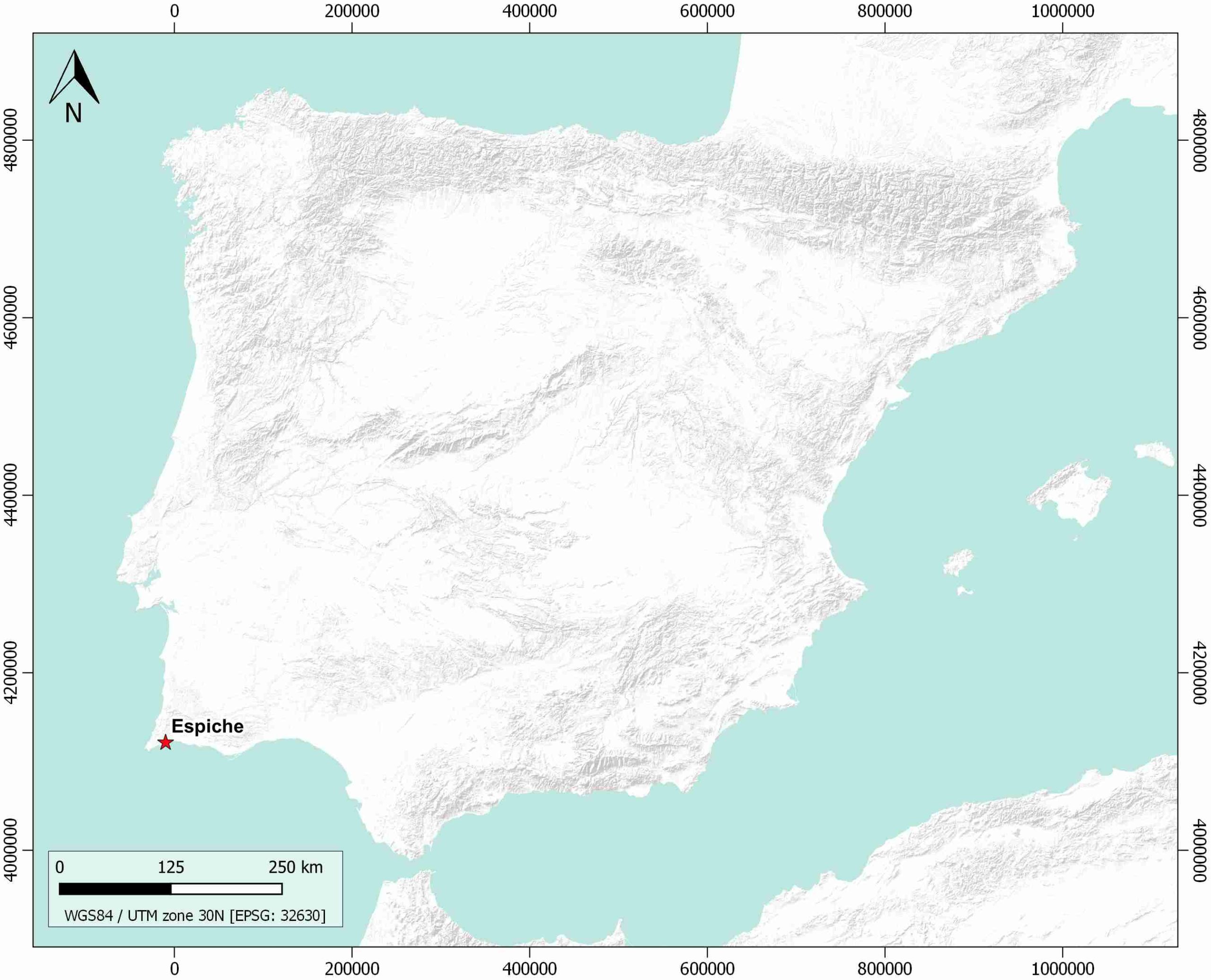
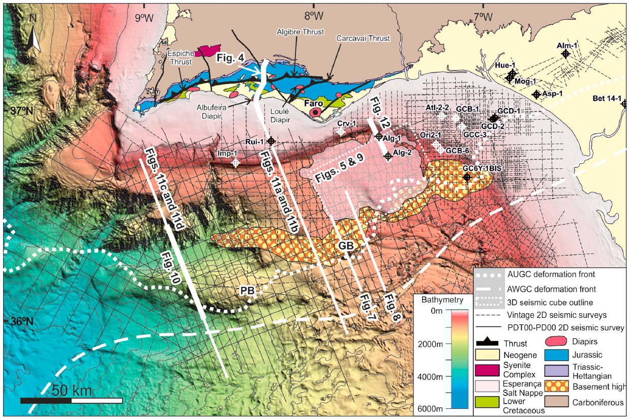
| Geological Setting | Algarve Basin, Western Domain |
| Outcropping/buried | Partially buried |
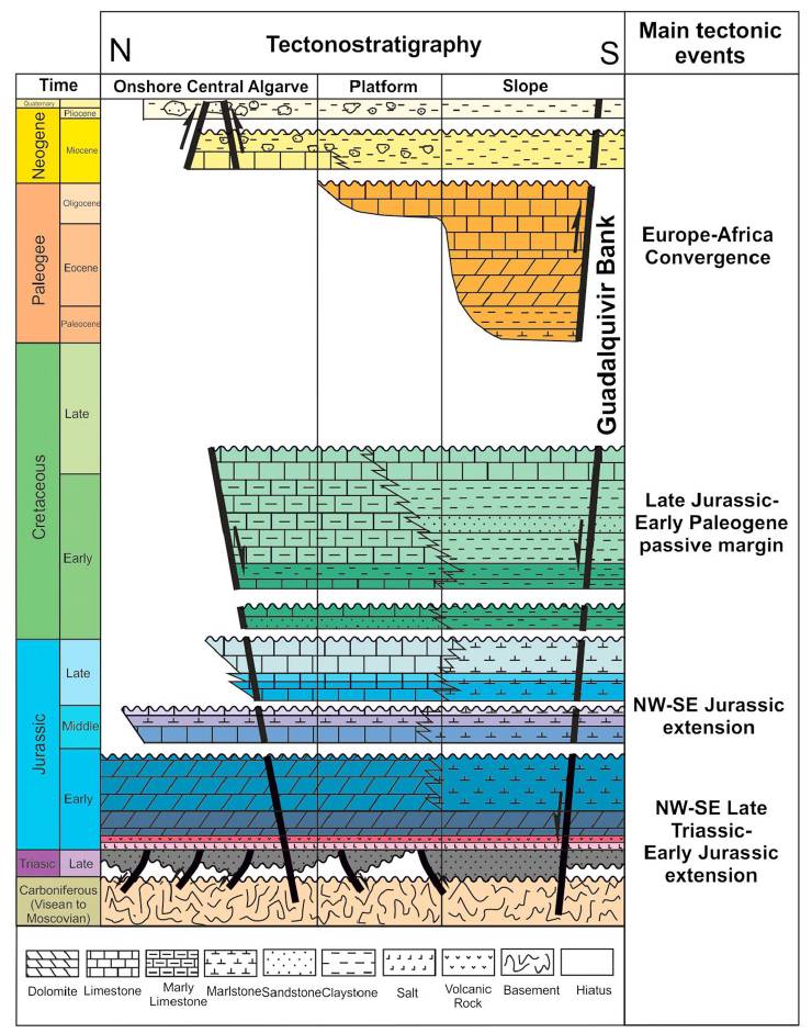
| Evaporite unit/s name | Hettangian Evaporites Unit |
| Evaporite unit/s age | Hettangian (Lower Jurassic) |
| Evaporite unit/s origin | Marine |
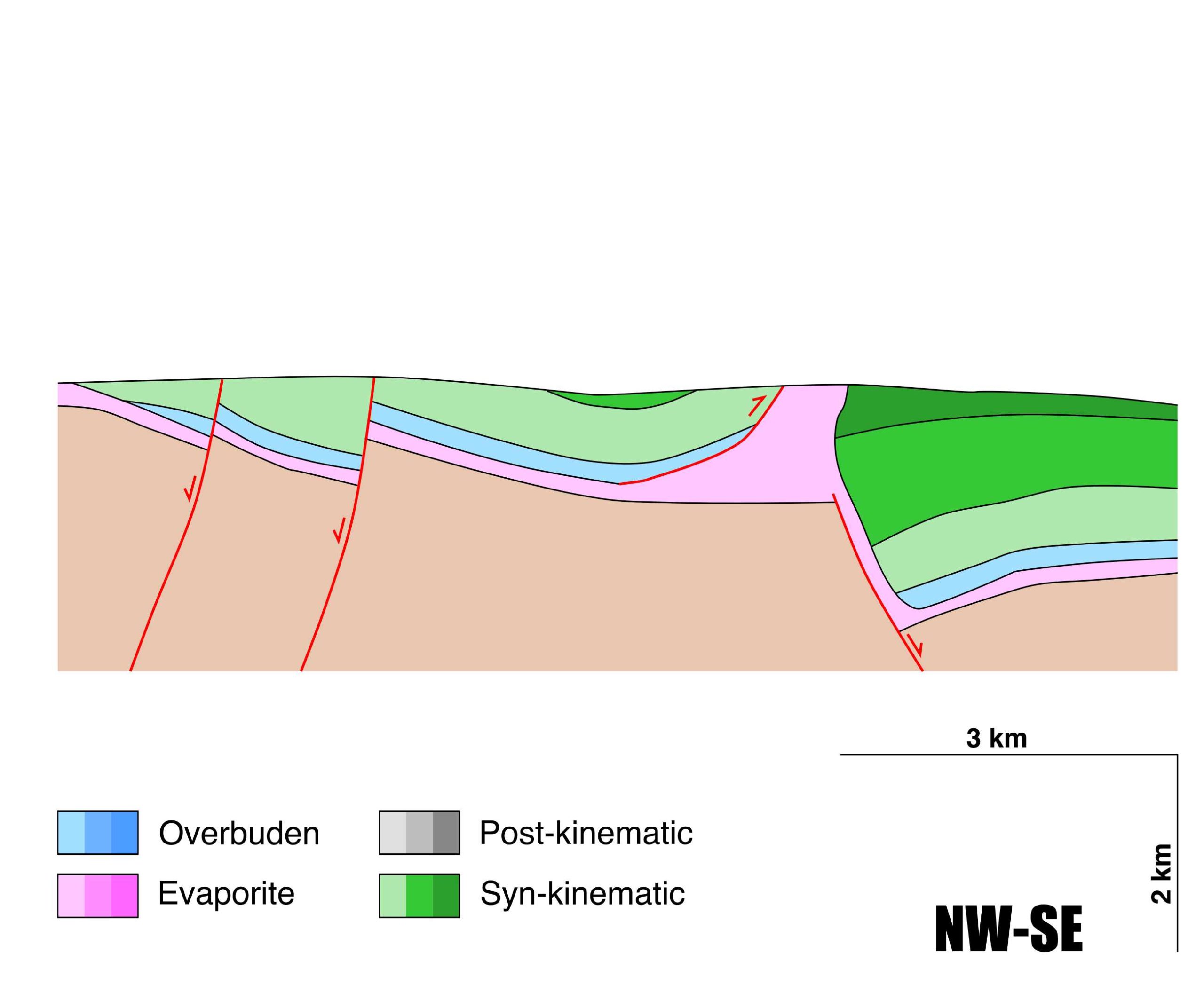
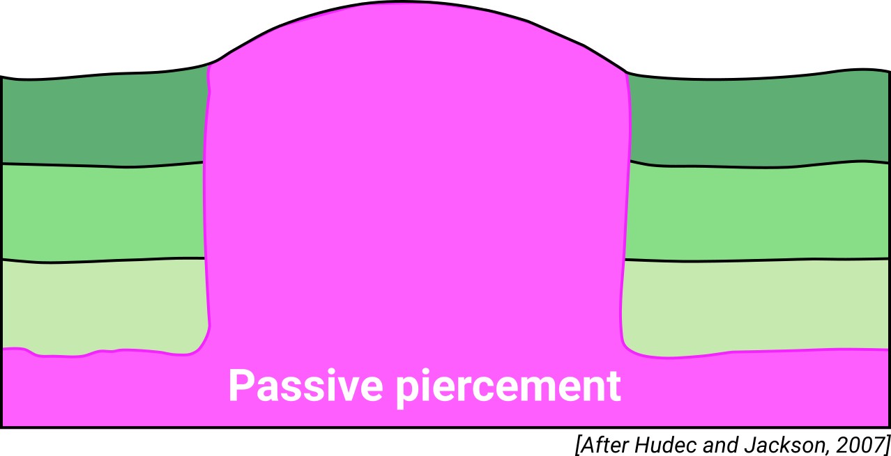
| Classif. (Hudec and Jackson, 2009) | Passive piercement |
| Classif. (Jackson and Talbot, 1986) | Salt wall |
| Age of evaporite flow or deformation (when deformed) | late Oligocene, Lower Oligocene, Middle Jurassic to Lower Cretaceous |
| Other comments | Linked to the south-eastwards dipping Espiche normal fault, overprinted by a southeast vergent thrust. Salt wall was overprinted by the pre-Miocene contractional tectonics in the Algarve basin. The Espiche fault is the western continuation of the Algibre Fault, which controlled the evaporite deposition (no evaporites found north of the Algibre Fault). |
Generic Data
| Unique ID | 141 |
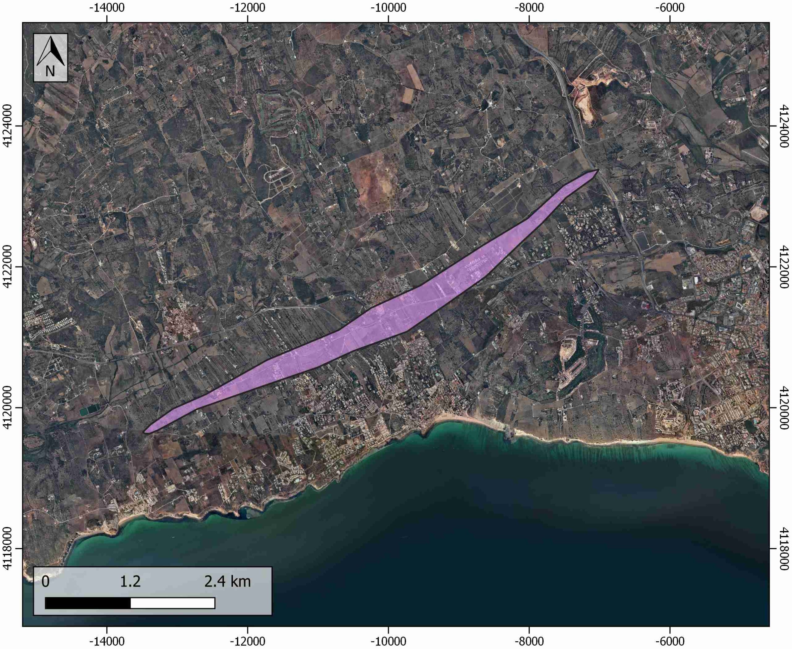
| Name | Espiche |
| Structure type | Evaporite diapir |
| Deformed/Undeformed | Deformed |
| Buried/Outcropping | Outcropping |
| Geological setting | Algarve basin |
| Geological Regional Setting | Western Domain |
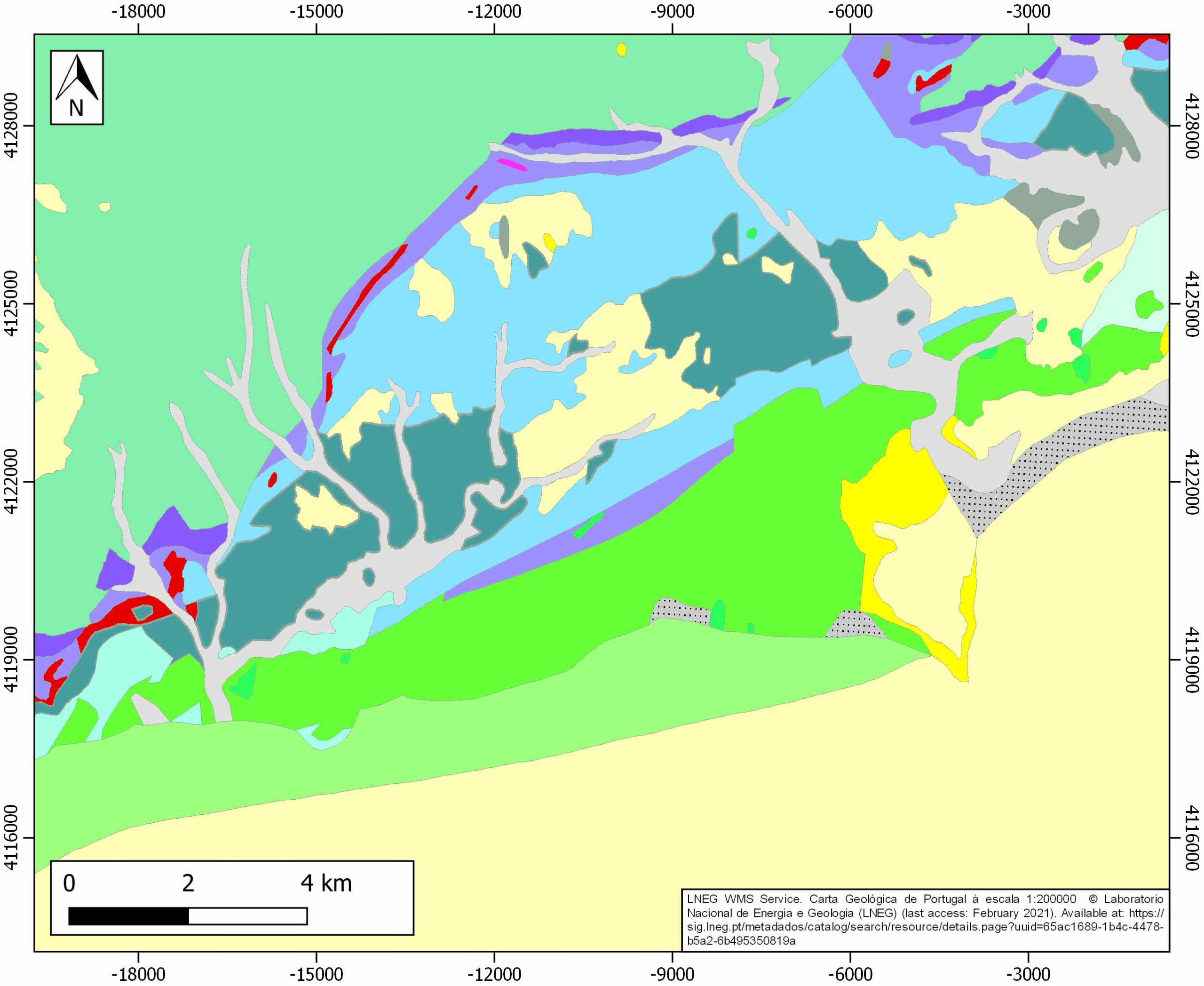
| Evaporite unit/s name | Hettangian Evaporites |
| Evaporite unit/s age | Hettangian (Lower Jurassic) |
| Evaporite unit/s era | Mesozoic |
| Evaporite unit/s origin | Marine |
| Evaporite unit/s composition | Claystonestone-Gypsum-Halite |
| Post-kinematic unit/s (or post-evaporite units when evaporites are undeformed) | Pliocene and Quaternary (alluvial and colluvial detrital deposits) |
| Post-kinematic unit/s age (or post-evaporite units when evaporites are undeformed) | Pliocene-Holocene |
| Classification (Hudec and Jackson, 2009) | Passive Piercement |
| Classification (Jackson and Talbot, 1986) | Salt wall |
| Mining activity? | N |
| Mining activity start | |
| Mining activity end | |
| Mining galleries? | |
| Mining products | |
| Mining sub-products | |
| Evaporite flow? | Y |
| Age of evaporite flow | Middle Jurassic-Early Cretaceous and Oligocene (reactivation stage) |
| Flow or deformation triggering mechanisms | Extensional regime in the Algarve basin (main stage) Alpine compression (reactivation stage) |
| Flow-linked structures? | Y |
| Halokinetic structures | Syncline-Anticline folding / thrust faults / halite recrystallization veins / progressive unconformities |
| Post-evaporite and pre-kinematic unit/s (overbuden) | Early Jurassic (dolostones and limestones) |
| Syn-kinematic unit/s | Callovian (yellow marls and limestones) ; Oxfordian (limestones and marly limestones intercalation) ; Kimmeridgian (limestones and dolostones) ; Tithonian (limestones) Lower Cretaceous (limestones, marlstones, conglomerates and sandstones) |
| Available seismic profiles | |
| Available boreholes | |
| Additional comments | Linked to the south-eastwards dipping Espiche normal fault, overprinted by a southeast vergent thrust. Salt wall was overprinted by the pre-Miocene contractional tectonics in the Algarve basin. The Espiche fault is the Espiche Fault is the western continuation of the Algibre Fault, which controlled the evaporite deposition (no evaporites found north of the Algibre Fault |
Mining Data
| UNIQUE_ID | 141 |
| Minning exploitations within <2km? | N |
| Historical/Active | |
| Exploitation name #1 | |
| Exploitation ID (Spanish National Mining Cadastre) #1 | |
| Municipality #1 | |
| Province #1 | |
| Company #1 | |
| Main minning Products #1 | |
| Exploitation name #2 | |
| Exploitation ID (Spanish National Mining Cadastre) #2 | |
| Municipality #2 | |
| Province #2 | |
| Company #2 | |
| Main minning Products #2 | |
| Exploitation name #3 | |
| Exploitation ID (Spanish National Mining Cadastre) #3 | |
| Municipality #3 | |
| Province #3 | |
| Company #3 | |
| Main minning Products #3 |
Quantitative Data
| UNIQUE_ID | 141 |
| Outcropping area (km2) | 2.21025 |
| Horizontal intersection area (km2) (when buried) | Not buried |
| Depth of intersection area (km2) (when buried) | Not buried |
| Max. Width (Km) | 7.5 |
| Max. Length (Km) | 0.9 |
| Max. Evaporites thickness (km) | 1 |
| Max. Deformation age (Ma) | 166 |
| Min. Deformation age (Ma) | 23 |
| Deformation stages | 2 |
Reference Data
| UNIQUE_ID | 141 |
| Section source | Ramos, A., Fernández, O., Terrinha, P., & Muñoz, J. A., 2016. Extension and inversion structures in the Tethys–Atlantic linkage zone, Algarve Basin, Portugal. International Journal of Earth Sciences, 105(5), 1663-1679. [link] |
| Well / Borehole availability #1 | n.a. |
| Well / Borehole availability #2 | n.a. |
| Available data (Stratigraphy) #1 | Ramos, A., Fernández, O., Terrinha, P., & Muñoz, J. A., 2017. Neogene to recent contraction and basin inversion along the Nubia‐Iberia boundary in SW Iberia. Tectonics, 36(2), 257-286. [link] |
| Available data (Stratigraphy) #2 | Stow, D. A., Faugères, J. C., Gonthier, E., Cremer, M., Llave, E., Hernández-Molina, F. J., …, Diaz-Del-Rio, V., 2002. Faro-Albufeira drift complex, northern Gulf of Cadiz. Geological Society, London, Memoirs, 22(1), 137-154. [link] |
| Available data (Stratigraphy) #3 | Ramos, A., Fernández, O., Muñoz, J. A., Terrinha, P., 2017. Impact of basin structure and evaporite distribution on salt tectonics in the Algarve Basin, Southwest Iberian margin. Marine and Petroleum Geology, 88, 961-984. [link] |
| Available data (Stratigraphy) #4 | Ramos, A., Fernández, O., Terrinha, P., & Muñoz, J. A., 2016. Extension and inversion structures in the Tethys–Atlantic linkage zone, Algarve Basin, Portugal. International Journal of Earth Sciences, 105(5), 1663-1679. [link] |
| Available data (Stratigraphy) #5 | Ramos, A., Fernández, O., Terrinha, P., Muñoz, J. A., Arnaiz, Á., 2020. Paleogeographic evolution of a segmented oblique passive margin: the case of the SW Iberian margin. International Journal of Earth Sciences, 109, 1871-1895. [link] |
| Available data (Stratigraphy) #6 | Terrinha, P., Rocha, R., Rey, J., Cachão, M., Moura, D., Roque, C., …, Bensalah, M. K., 2006. A Bacia do Algarve: Estratigrafia, paleogeografia e tectónica. Geologia de Portugal no contexto da Ibéria, 1-138. [link] |
| Regional Stratigraphy | Ramos, A., Fernández, O., Terrinha, P., & Muñoz, J. A., 2017. Neogene to recent contraction and basin inversion along the Nubia‐Iberia boundary in SW Iberia. Tectonics, 36(2), 257-286. [link] |
| Seismic data availability #1 | n.a. |
| Seismic data availability #2 | n.a. |
| Seismic data availability #3 | n.a. |
| Available data (Structure) #1 | Ramos, A., Fernández, O., Terrinha, P., & Muñoz, J. A., 2017. Neogene to recent contraction and basin inversion along the Nubia‐Iberia boundary in SW Iberia. Tectonics, 36(2), 257-286. [link] |
| Available data (Structure) #2 | Ramos, A., Fernández, O., Muñoz, J. A., Terrinha, P., 2017. Impact of basin structure and evaporite distribution on salt tectonics in the Algarve Basin, Southwest Iberian margin. Marine and Petroleum Geology, 88, 961-984. [link] |
| Available data (Structure) #3 | Lopes, F. C., Cunha, P. P., Le Gall, B., 2006. Cenozoic seismic stratigraphy and tectonic evolution of the Algarve margin (offshore Portugal, southwestern Iberian Peninsula). Marine Geology, 231(1-4), 1-36. [link] |
| Available data (Structure) #4 | Ramos, A., Fernández, O., Terrinha, P., Muñoz, J. A., Arnaiz, Á., 2020. Paleogeographic evolution of a segmented oblique passive margin: the case of the SW Iberian margin. International Journal of Earth Sciences, 109, 1871-1895. [link] |
| Available data (Structure) #5 | Matias, H., Kress, P., Terrinha, P., Mohriak, W., Menezes, P. T., Matias, L., Santos, F., Sandnes, F., 2011. Salt tectonics in the western Gulf of Cadiz, southwest Iberia. AAPG bulletin, 95(10), 1667-1698. [link] |
| Available data (Structure) #6 | Kullberg, J. C., Pais, J., Manuppella, G., 2009. Aspectos gerais da tectónica alpina no Algarve. Ciências da Terra/Earth Sciences Journal, 11. [link] |
| Available data (Analogue modelling) #1 | n.a. |
| Available data (Analogue modelling) #2 | n.a. |
| Available data (Analogue modelling) #3 | n.a. |
| Available data (Gravimetry – Tomography) #1 | Ayala, C., Bohoyo, F., Maestro, A., Reguera, M. I., Torne, M., Rubio, F., Fernández, M., García-Lobón, J. L., 2016. Updated Bouguer anomalies of the Iberian Peninsula: a new perspective to interpret the regional geology. Journal of Maps, 12(5), 1089-1092. [link] |
| Available data (Gravimetry – Tomography) #2 | n.a. |
| Available data (Gravimetry – Tomography) #3 | n.a. |
| Available data (Geochemistry) #1 | n.a. |
| Available data (Geochemistry) #2 | n.a. |
| Available data (Geochemistry) #3 | n.a. |
| Available data (Geochemistry) #4 | n.a. |
| Available data (Petrophysics) #1 | n.a. |
| Available data (Petrophysics) #2 | n.a. |
| IGME Geological Map (MAGNA50) Sheet number | n.a. |
| Other Maps #1 (source) | Ramos, A., Fernández, O., Terrinha, P., & Muñoz, J. A., 2017. Neogene to recent contraction and basin inversion along the Nubia‐Iberia boundary in SW Iberia. Tectonics, 36(2), 257-286. [link] |
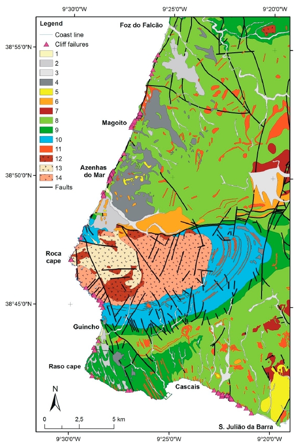
| Other Maps #2 (source) | Marques, F., 2018. Regional scale sea cliff hazard assessment at Sintra and Cascais counties, western coast of Portugal. Geosciences, 8(3), 80. [link] |
| Other related references #1 | Terrinha, P., Kullberg, J. C., Neres, M., Alves, T., Ramos, A., Ribeiro, C., …, Fernández, Ó., 2019. Rifting of the southwest and west Iberia continental margins.In: Quesada C., Oliveira J. (eds) The Geology of Iberia: A Geodynamic Approach. Regional Geology Reviews. Springer, Cham. [link] |
| Other related references #2 | García, M., Llave, E., Hernandez-Molina, F. J., Lobo, F. J., Ercilla, G., Alonso, B., …, Fernandez-Salas, L. M., 2020. The role of late Quaternary tectonic activity and sea-level changes on sedimentary processes interaction in the Gulf of Cadiz upper and middle continental slope (SW Iberia). Marine and Petroleum Geology, 121, 104595. [link] |
| Other related references #3 | Ribeiro, C., Terrinha, P., Andrade, A., Fonseca, B., Caetano, M., Neres, M., …, Manhita, A, 2017. Non-halide sediments from the Loule diapir salt mine: characterization and environmental significance. In EGU General Assembly Conference Abstracts (p. 17094). [link] |
| Other related references #4 | Luján, M., Lobo, F. J., Mestdagh, T., Vázquez, J. T., Fernández-Puga, M. C., Van Rooij, D., 2020. Pliocene-Quaternary deformational structures in the eastern Algarve continental shelf, Gulf of Cadiz. Geogaceta, 67, 3-6. [link] |
Well and Seismic Data
| UNIQUE_ID | 141 |
| Seismic survey name #1 | |
| Across structure? #1 | |
| Seismic profile ID (IGME) #1 | |
| Seismic profile code #1 | |
| Seismic profile name #1 | |
| Seismic survey year #1 | |
| Data repository #1 | |
| Length (km) #1 | |
| Seismic survey name #2 | |
| Across structure? #2 | |
| Seismic profile ID (IGME) #2 | |
| Seismic profile code #2 | |
| Seismic profile name #2 | |
| Seismic survey year #2 | |
| Data repository #2 | |
| Length (km) #2 | |
| Seismic survey name #3 | |
| Across structure? #3 | |
| Seismic profile ID (IGME) #3 | |
| Seismic profile code #3 | |
| Seismic profile name #3 | |
| Seismic survey year #3 | |
| Data repository #3 | |
| Length (km) #3 | |
| Seismic survey name #4 | |
| Across structure? #4 | |
| Seismic profile ID (IGME) #4 | |
| Seismic profile code #4 | |
| Seismic profile name #4 | |
| Seismic survey year #4 | |
| Data repository #4 | |
| Length (km) #4 | |
| Seismic survey name #5 | |
| Across structure? #5 | |
| Seismic profile ID (IGME) #5 | |
| Seismic profile code #5 | |
| Seismic profile name #5 | |
| Seismic survey year #5 | |
| Data repository #5 | |
| Length (km) #5 | |
| Seismic survey name #6 | |
| Across structure? #6 | |
| Seismic profile ID (IGME) #6 | |
| Seismic profile code #6 | |
| Seismic profile name #6 | |
| Seismic survey year #6 | |
| Data repository #6 | |
| Length (km) #6 | |
| Seismic survey name #7 | |
| Across structure? #7 | |
| Seismic profile ID (IGME) #7 | |
| Seismic profile code #7 | |
| Seismic profile name #7 | |
| Seismic survey year #7 | |
| Data repository #7 | |
| Length (km) #7 | |
| Seismic survey name #8 | |
| Across structure? #8 | |
| Seismic profile ID (IGME) #8 | |
| Seismic profile code #8 | |
| Seismic profile name #8 | |
| Seismic survey year #8 | |
| Data repository #8 | |
| Length (km) #8 | |
| Seismic survey name #9 | |
| Across structure? #9 | |
| Seismic profile ID (IGME) #9 | |
| Seismic profile code #9 | |
| Seismic profile name #9 | |
| Seismic survey year #9 | |
| Data repository #9 | |
| Length (km) #9 | |
| Seismic survey name #10 | |
| Across structure? #10 | |
| Seismic profile ID (IGME) #10 | |
| Seismic profile code #10 | |
| Seismic profile name #10 | |
| Seismic survey year #10 | |
| Data repository #10 | |
| Length (km) #10 | |
| Seismic survey name #11 | |
| Across structure? #11 | |
| Seismic profile ID (IGME) #11 | |
| Seismic profile code #11 | |
| Seismic profile name #11 | |
| Seismic survey year #11 | |
| Data repository #11 | |
| Length (km) #11 | |
| Seismic survey name #12 | |
| Across structure? #12 | |
| Seismic profile ID (IGME) #12 | |
| Seismic profile code #12 | |
| Seismic profile name #12 | |
| Seismic survey year #12 | |
| Data repository #12 | |
| Length (km) #12 | |
| Seismic survey name #13 | |
| Across structure? #13 | |
| Seismic profile ID (IGME) #13 | |
| Seismic profile code #13 | |
| Seismic profile name #13 | |
| Seismic survey year #13 | |
| Data repository #13 | |
| Length (km) #13 | |
| Seismic survey name #14 | |
| Across structure? #14 | |
| Seismic profile ID (IGME) #14 | |
| Seismic profile code #14 | |
| Seismic profile name #14 | |
| Seismic survey year #14 | |
| Data repository #14 | |
| Length (km) #14 | |
| Seismic survey name #15 | |
| Across structure? #15 | |
| Seismic profile ID (IGME) #15 | |
| Seismic profile code #15 | |
| Seismic profile name #15 | |
| Seismic survey year #15 | |
| Data repository #15 | |
| Length (km) #15 | |
| Seismic survey name #16 | |
| Across structure? #16 | |
| Seismic profile ID (IGME) #16 | |
| Seismic profile code #16 | |
| Seismic profile name #16 | |
| Seismic survey year #16 | |
| Data repository #16 | |
| Length (km) #16 | |
| Seismic survey name #17 | |
| Across structure? #17 | |
| Seismic profile ID (IGME) #17 | |
| Seismic profile code #17 | |
| Seismic profile name #17 | |
| Seismic survey year #17 | |
| Data repository #17 | |
| Length (km) #17 | |
| Seismic survey name #18 | |
| Across structure? #18 | |
| Seismic profile ID (IGME) #18 | |
| Seismic profile code #18 | |
| Seismic profile name #18 | |
| Seismic survey year #18 | |
| Data repository #18 | |
| Length (km) #18 | |
| Seismic survey name #19 | |
| Across structure? #19 | |
| Seismic profile ID (IGME) #19 | |
| Seismic profile code #19 | |
| Seismic profile name #19 | |
| Seismic survey year #19 | |
| Data repository #19 | |
| Length (km) #19 | |
| Seismic survey name #20 | |
| Across structure? #20 | |
| Seismic profile ID (IGME) #20 | |
| Seismic profile code #20 | |
| Seismic profile name #20 | |
| Seismic survey year #20 | |
| Data repository #20 | |
| Length (km) #20 | |
| Seismic survey name #21 | |
| Across structure? #21 | |
| Seismic profile ID (IGME) #21 | |
| Seismic profile code #21 | |
| Seismic profile name #21 | |
| Seismic survey year #21 | |
| Data repository #21 | |
| Length (km) #21 | |
| Borehole name #1 | |
| Company #1 | |
| Traget #1 | |
| Across structure? #1 | |
| Borehole name #2 | |
| Company #2 | |
| Traget #2 | |
| Across structure? #2 | |
| Borehole name #3 | |
| Company #3 | |
| Traget #3 | |
| Across structure? #3 | |
| Borehole name #4 | |
| Company #4 | |
| Traget #4 | |
| Across structure? #4 | |
| Borehole name #5 | |
| Company #5 | |
| Traget #5 | |
| Across structure? #5 | |
| Borehole name #6 | |
| Company #6 | |
| Traget #6 | |
| Across structure? #6 | |
| Borehole name #7 | |
| Company #7 | |
| Traget #7 | |
| Across structure? #7 | |
| Borehole name #8 | |
| Company #8 | |
| Traget #8 | |
| Across structure? #8 | |
| Borehole name #9 | |
| Company #9 | |
| Traget #9 | |
| Across structure? #9 | |
| Borehole name #10 | |
| Company #10 | |
| Traget #10 | |
| Across structure? #10 | |
| Borehole name #11 | |
| Company #11 | |
| Traget #11 | |
| Across structure? #11 | |
| Borehole name #12 | |
| Company #12 | |
| Traget #12 | |
| Across structure? #12 | |
| Borehole name #13 | |
| Company #13 | |
| Traget #13 | |
| Across structure? #13 | |
| Borehole name #14 | |
| Company #14 | |
| Traget #14 | |
| Across structure? #14 | |
| Borehole name #15 | |
| Company #15 | |
| Traget #15 | |
| Across structure? #15 |
Geographical Data (EPSG:4326 - WGS 84)
| UNIQUE_ID | 141 |
| X Centroid (Structure shape) | -8.737555 |
| Y Centroid (Structure shape) | -8.737555 |
| Xmin (Structure shape) | -8.774651 |
| Xmax (Structure shape) | -8.704614 |
| Ymin (Structure shape) | 37.082280 |
| Ymax (Structure shape) | 37.119448 |
| Xmin seismic line #1 | |
| Xmax seismic line #1 | |
| Ymin seismic line #1 | |
| Ymax seismic line #1 | |
| Xmin seismic line #2 | |
| Xmax seismic line #2 | |
| Ymin seismic line #2 | |
| Ymax seismic line #2 | |
| Xmin seismic line #3 | |
| Xmax seismic line #3 | |
| Ymin seismic line #3 | |
| Ymax seismic line #3 | |
| Xmin seismic line #4 | |
| Xmax seismic line #4 | |
| Ymin seismic line #4 | |
| Ymax seismic line #4 | |
| Xmin seismic line #5 | |
| Xmax seismic line #5 | |
| Ymin seismic line #5 | |
| Ymax seismic line #5 | |
| Xmin seismic line #6 | |
| Xmax seismic line #6 | |
| Ymin seismic line #6 | |
| Ymax seismic line #6 | |
| Xmin seismic line #7 | |
| Xmax seismic line #7 | |
| Ymin seismic line #7 | |
| Ymax seismic line #7 | |
| Xmin seismic line #8 | |
| Xmax seismic line #8 | |
| Ymin seismic line #8 | |
| Ymax seismic line #8 | |
| Xmin seismic line #9 | |
| Xmax seismic line #9 | |
| Ymin seismic line #9 | |
| Ymax seismic line #9 | |
| Xmin seismic line #10 | |
| Xmax seismic line #10 | |
| Ymin seismic line #10 | |
| Ymax seismic line #10 | |
| Xmin seismic line #11 | |
| Xmax seismic line #11 | |
| Ymin seismic line #11 | |
| Ymax seismic line #11 | |
| Xmin seismic line #12 | |
| Xmax seismic line #12 | |
| Ymin seismic line #12 | |
| Ymax seismic line #12 | |
| Xmin seismic line #13 | |
| Xmax seismic line #13 | |
| Ymin seismic line #13 | |
| Ymax seismic line #13 | |
| Xmin seismic line #14 | |
| Xmax seismic line #14 | |
| Ymin seismic line #14 | |
| Ymax seismic line #14 | |
| Xmin seismic line #15 | |
| Xmax seismic line #15 | |
| Ymin seismic line #15 | |
| Ymax seismic line #15 | |
| Xmin seismic line #16 | |
| Xmax seismic line #16 | |
| Ymin seismic line #16 | |
| Ymax seismic line #16 | |
| Xmin seismic line #17 | |
| Xmax seismic line #17 | |
| Ymin seismic line #17 | |
| Ymax seismic line #17 | |
| Xmin seismic line #18 | |
| Xmax seismic line #18 | |
| Ymin seismic line #18 | |
| Ymax seismic line #18 | |
| Xmin seismic line #19 | |
| Xmax seismic line #19 | |
| Ymin seismic line #19 | |
| Ymax seismic line #19 | |
| Xmin seismic line #20 | |
| Xmax seismic line #20 | |
| Ymin seismic line #20 | |
| Ymax seismic line #20 | |
| Xmin seismic line #21 | |
| Xmax seismic line #21 | |
| Ymin seismic line #21 | |
| Ymax seismic line #21 | |
| X borehole #1 | |
| Y borehole #1 | |
| X borehole #2 | |
| Y borehole #2 | |
| X borehole #3 | |
| Y borehole #3 | |
| X borehole #4 | |
| Y borehole #4 | |
| X borehole #5 | |
| Y borehole #5 | |
| X borehole #6 | |
| Y borehole #6 | |
| X borehole #7 | |
| Y borehole #7 | |
| X borehole #8 | |
| Y borehole #8 | |
| X borehole #9 | |
| Y borehole #9 | |
| X borehole #10 | |
| Y borehole #10 | |
| X borehole #11 | |
| Y borehole #11 | |
| X borehole #12 | |
| Y borehole #12 | |
| X borehole #13 | |
| Y borehole #13 | |
| X borehole #14 | |
| Y borehole #14 | |
| X borehole #15 | |
| Y borehole #15 |

