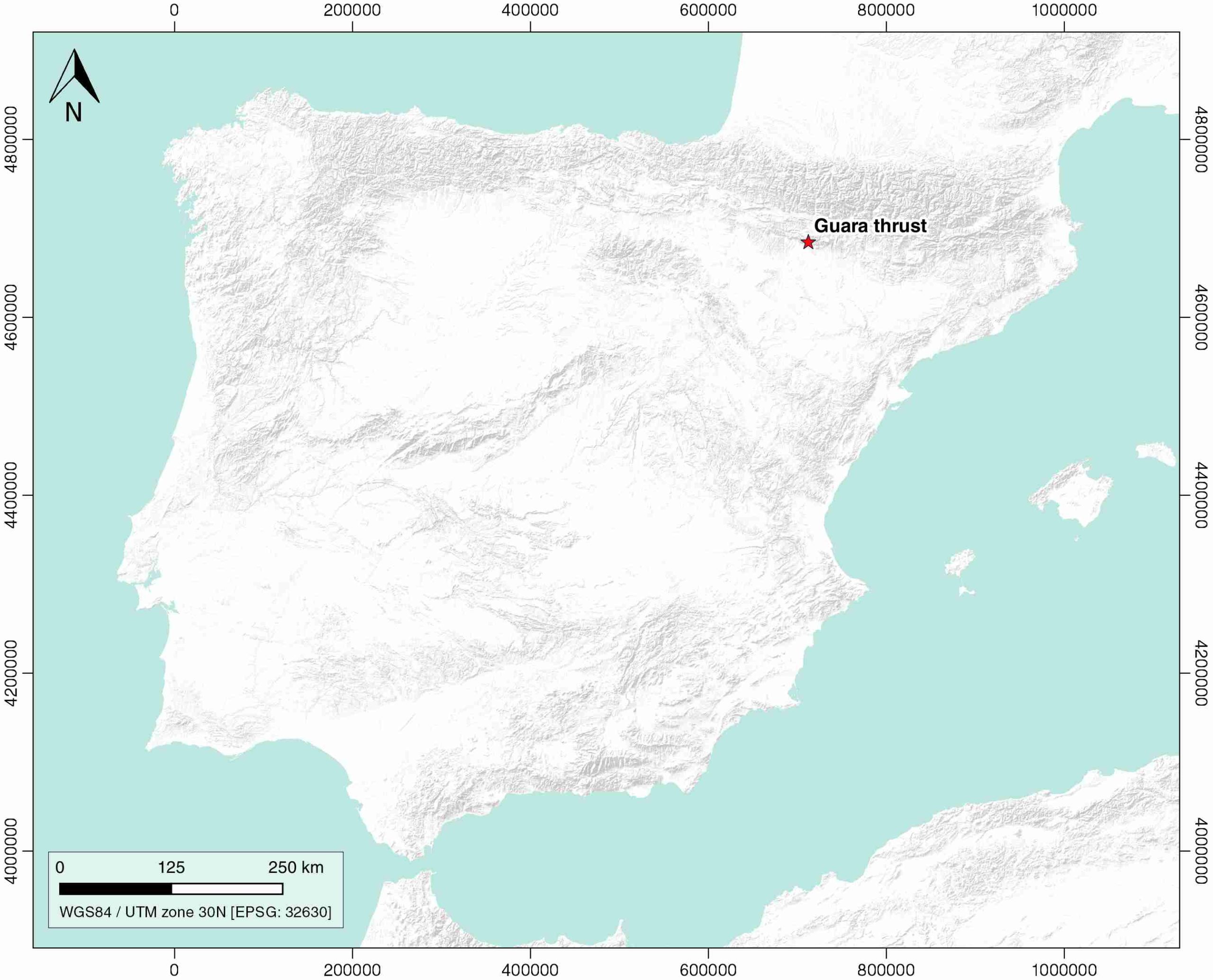
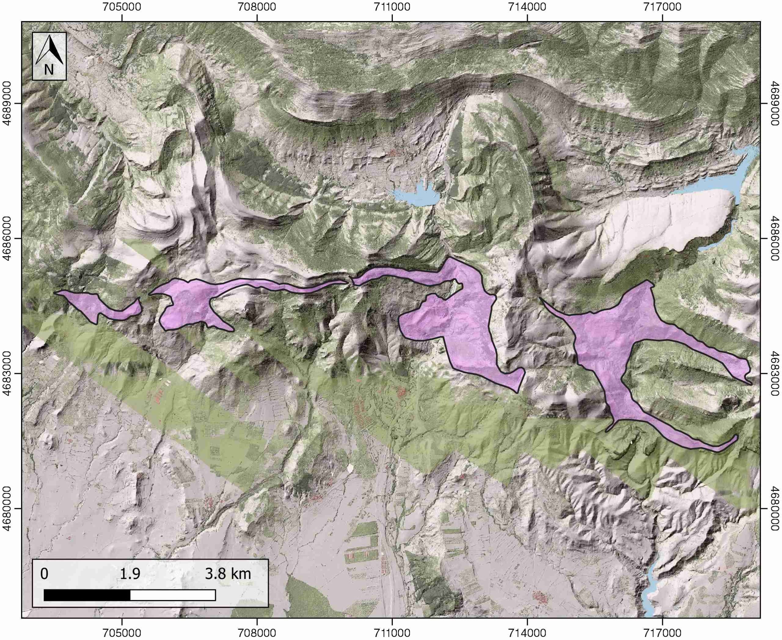
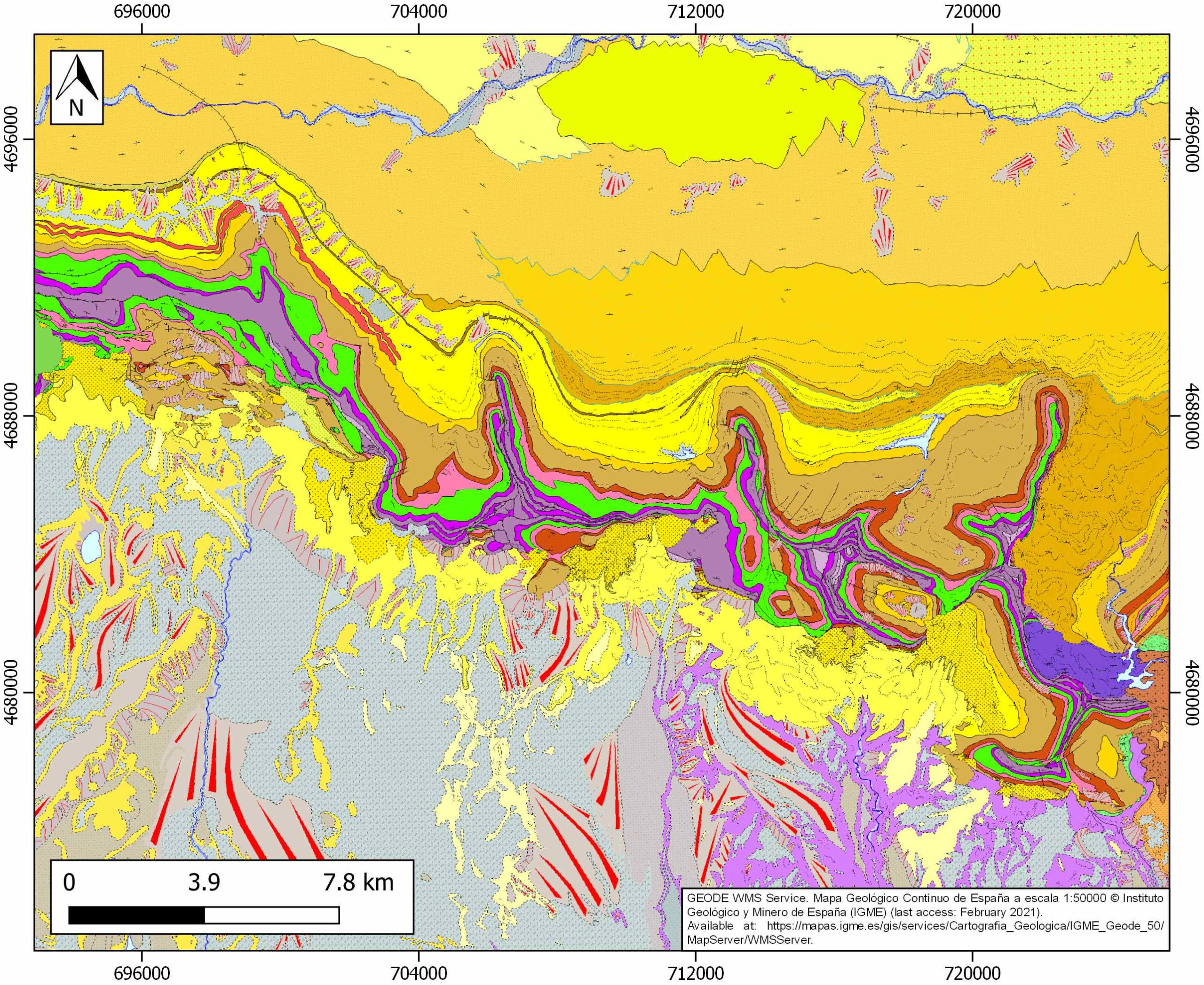
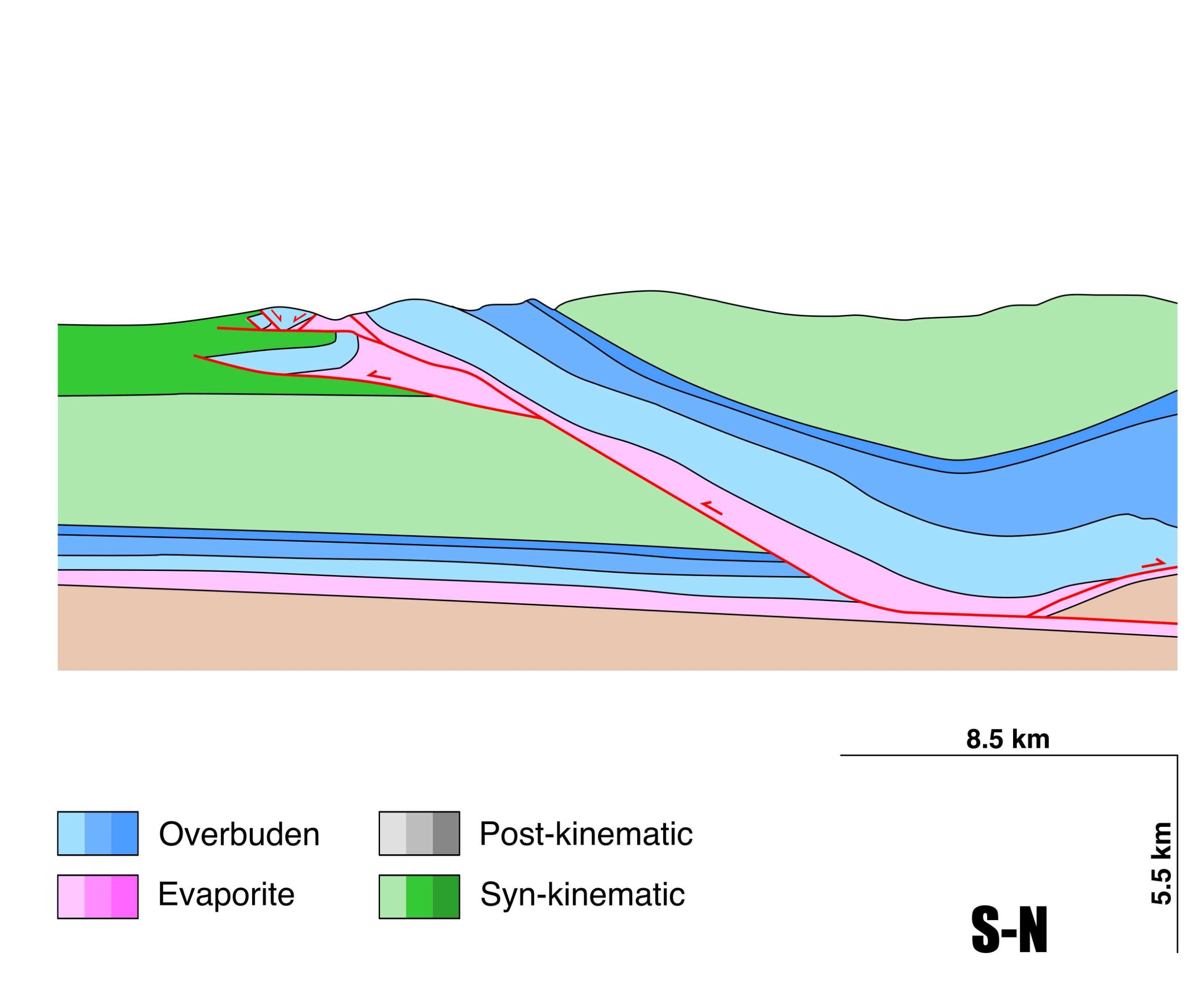
Guarga thrust
ID #062
General Information
| Structure type | Evaporite-detached thrust |
| Deformed/Undeformed | Deformed |
| Geological Setting | External Ranges, Southern Pyrenees |
| Outcropping/buried | Outcropping |
| Evaporite unit/s name | El Pont de Suert Fm. |
| Evaporite unit/s age | Upper Anisian and Carnian-Rhaetian (Middle-Upper Triassic) |
| Evaporite unit/s origin | Marine |
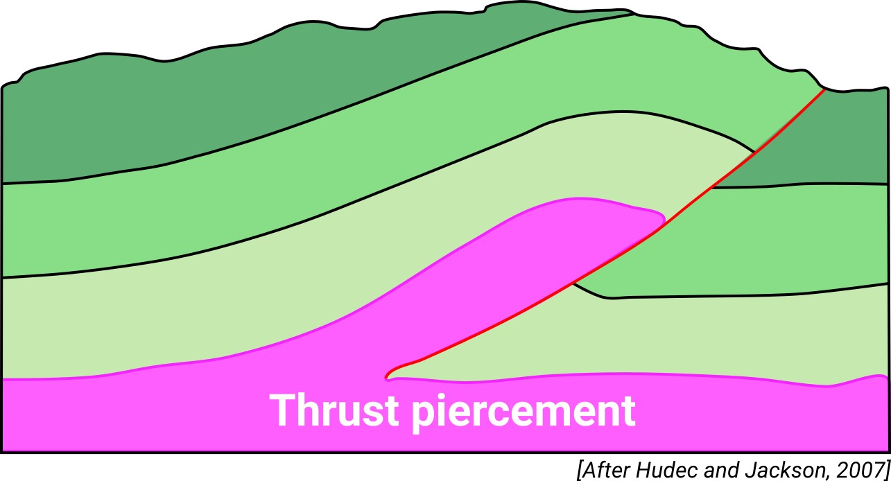
| Classif. (Hudec and Jackson, 2009) | Thrust piercement |
| Classif. (Jackson and Talbot, 1986) | Salt wall |
| Age of evaporite flow or deformation (when deformed) | Oligocene to Miocene |
| Other comments | - |
Generic Data
| Unique ID | 62 |
| Name | Guarga thrust |
| Structure type | Evaporite-detached thrust |
| Deformed/Undeformed | Deformed |
| Buried/Outcropping | Outcropping |
| Geological setting | Southern Pyrenees |
| Geological Regional Setting | External Ranges |
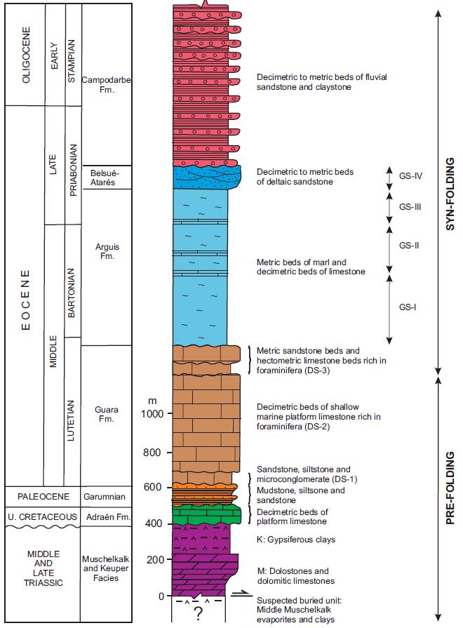
| Evaporite unit/s name | El Pont de Suert Fm. (Middle Muschelkalk and Keuper Facies) |
| Evaporite unit/s age | Upper Anisian and Carnian-Rhaetian (Middle-Upper Triassic) |
| Evaporite unit/s era | Mesozoic |
| Evaporite unit/s origin | Marine |
| Evaporite unit/s composition | Shale-Marlstone-Gypsum-Anhydrite-Halite |
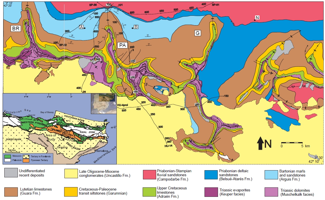
| Post-kinematic unit/s (or post-evaporite units when evaporites are undeformed) | Late Oligocene-Miocene (Uncastillo Fm., conglomerates), Quaternary (alluvial and colluvial detrital deposits) |
| Post-kinematic unit/s age (or post-evaporite units when evaporites are undeformed) | Late Oligocene-Holocene |
| Classification (Hudec and Jackson, 2009) | Thrust piercement |
| Classification (Jackson and Talbot, 1986) | Salt wall |
| Mining activity? | N |
| Mining activity start | |
| Mining activity end | |
| Mining galleries? | |
| Mining products | |
| Mining sub-products | |
| Evaporite flow? | Y |
| Age of evaporite flow | Late Rupelian – Aquitanian |
| Flow or deformation triggering mechanisms | Thrust emplacement |
| Flow-linked structures? | Y |
| Halokinetic structures | Thrust faults / thickness variations / joints / calcite veins |
| Post-evaporite and pre-kinematic unit/s (overbuden) | Upper Cretaceous (Adraen Fm., limestones) ; Cretaceous-Palaeocene (Garumnian, Tremp Fm., sandstones, mudstones) ; Lutetian (Guara Fm., limestones rich in foraminifera) ; Bartonian-Early Priabonian (Arguís Fm., marly siltstones and sandstones) ; Late Eocene (Belsué-Atarés Fm., sandstones, conglomerates) |
| Syn-kinematic unit/s | Late Eocene-Early Oligocene (Campodarbe Fm., sandstones and claystones) ; Late Chattian-Aquitanian (Uncastillo Fm., conglomerates) |
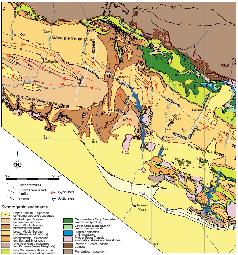
| Available seismic profiles | HU-14 / SP-56 / JH / SP-56 / SP-56 / SP-56 / HU-14 / HU-4-PROL / SP-73 / JH / SP-22 / SP-56 / SP-56 / SP-56 / 100 / HU-4 / SP-56 |
| Available boreholes | Surpirineica-1 |
| Additional comments | – |
Mining Data
| UNIQUE_ID | 62 |
| Minning exploitations within <2km? | N |
| Historical/Active | |
| Exploitation name #1 | |
| Exploitation ID (Spanish National Mining Cadastre) #1 | |
| Municipality #1 | |
| Province #1 | |
| Company #1 | |
| Main minning Products #1 | |
| Exploitation name #2 | |
| Exploitation ID (Spanish National Mining Cadastre) #2 | |
| Municipality #2 | |
| Province #2 | |
| Company #2 | |
| Main minning Products #2 | |
| Exploitation name #3 | |
| Exploitation ID (Spanish National Mining Cadastre) #3 | |
| Municipality #3 | |
| Province #3 | |
| Company #3 | |
| Main minning Products #3 |
Quantitative Data
| UNIQUE_ID | 62 |
| Outcropping area (km2) | 10.38518 |
| Horizontal intersection area (km2) (when buried) | Not buried |
| Depth of intersection area (km2) (when buried) | Not buried |
| Max. Width (Km) | 3.54753701 |
| Max. Length (Km) | 15.6265464 |
| Max. Evaporites thickness (km) | 1.2 |
| Max. Deformation age (Ma) | 33 |
| Min. Deformation age (Ma) | 20 |
| Deformation stages | 1 |
Reference Data
| UNIQUE_ID | 62 |
| Section source | Labaume, P., Teixell, A., 2018. 3D structure of subsurface thrusts in the eastern Jaca Basin, southern Pyrenees. Geologica Acta, 16(4), 477-498. [link] |
| Well / Borehole availability #1 | Cámara, P., Flinch, J. F., 2017. The southern Pyrenees: a salt-based fold-and-thrust belt. In Permo-Triassic Salt Provinces of Europe, North Africa and the Atlantic Margins (pp. 395-415). Elsevier. [link] |
| Well / Borehole availability #2 | Ortí, F., Pérez-López, A., Salvany, J. M., 2017. Triassic evaporites of Iberia: Sedimentological and palaeogeographical implications for the western Neotethys evolution during the Middle Triassic–Earliest Jurassic. Palaeogeography, palaeoclimatology, palaeoecology, 471, 157-180. [link] |
| Available data (Stratigraphy) #1 | Cámara, P., Klimowitz, J., 1985. Interpretación geodinámica de la vertiente centro-occidental surpirenaica (Cuencas de Jaca-Tremp). Estudios geológicos, 41(5-6), 391-404. [link] |
| Available data (Stratigraphy) #2 | Arenas, C., Millán, H., Pardo, G., Pocoví, A., 2001. Ebro Basin continental sedimentation associated with late compressional Pyrenean tectonics (north‐eastern Iberia): controls on basin margin fans and fluvial systems. Basin Research, 13(1), 65-89. [link] |
| Available data (Stratigraphy) #3 | Hoareau, G., Crognier, N., Lacroix, B., Aubourg, C., Roberts, N. M., Niemi, N., Branellec, M., Beaudoin, N, Ruiz, I. S, 2021. Combination of Δ47 and U-Pb dating in tectonic calcite veins unravel the last pulses related to the Pyrenean Shortening (Spain). Earth and Planetary Science Letters, 553, 116636. [link] |
| Available data (Stratigraphy) #4 | Puigdefábregas, C., 1975. La sedimentación molásica en la cuenca de Jaca. Monografías del Instituto de Estudios Pirenaicos. Número Extraordinario de la Revista Pirineos, 104, 153pp. [link] |
| Available data (Stratigraphy) #5 | Cámara, P., Flinch, J. F., 2017. The southern Pyrenees: a salt-based fold-and-thrust belt. In Permo-Triassic Salt Provinces of Europe, North Africa and the Atlantic Margins (pp. 395-415). Elsevier. [link] |
| Available data (Stratigraphy) #6 | Oliva-Urcia, B., Beamud, E., Arenas, C., Pueyo, E. L., Garcés, M., Soto, R., …, Pérez-Rivarés, F. J., 2019. Dating the northern deposits of the Ebro foreland basin; implications for the kinematics of the SW Pyrenean front. Tectonophysics, 765, 11-34. [link] |
| Regional Stratigraphy | Vidal-Royo, O., Muñoz, J. A., Hardy, S., Koyi, H., Cardozo, N., 2013. Structural evolution of the Pico del Águila anticline (External Sierras, southern Pyrenees) derived from sandbox, numerical and 3D structural modelling techniques. Geologica Acta: an international earth science journal, 11(1), 1-23. [link] |
| Seismic data availability #1 | Vidal-Royo, O., Muñoz, J. A., Hardy, S., Koyi, H., Cardozo, N., 2013. Structural evolution of the Pico del Águila anticline (External Sierras, southern Pyrenees) derived from sandbox, numerical and 3D structural modelling techniques. Geologica Acta: an international earth science journal, 11(1), 1-23. [link] |
| Seismic data availability #2 | Cámara, P., Flinch, J. F., 2017. The southern Pyrenees: a salt-based fold-and-thrust belt. In Permo-Triassic Salt Provinces of Europe, North Africa and the Atlantic Margins (pp. 395-415). Elsevier. [link] |
| Seismic data availability #3 | Labaume, P., Teixell, A., 2018. 3D structure of subsurface thrusts in the eastern Jaca Basin, southern Pyrenees. Geologica Acta, 16(4), 477-498. [link] |
| Available data (Structure) #1 | Cámara, P., Klimowitz, J., 1985. Interpretación geodinámica de la vertiente centro-occidental surpirenaica (Cuencas de Jaca-Tremp). Estudios geológicos, 41(5-6), 391-404. [link] |
| Available data (Structure) #2 | Huyghe, D., Mouthereau, F., Castelltort, S., Filleaudeau, P. Y., Emmanuel, L., 2009. Paleogene propagation of the southern Pyrenean thrust wedge revealed by finite strain analysis in frontal thrust sheets: Implications for mountain building. Earth and Planetary Science Letters, 288(3-4), 421-433. [link] |
| Available data (Structure) #3 | Millán, H., Oliva, B., Pocoví, J., 2006. La transversal de Gavarnie-Guara; estructura y edad de los mantos de Gavarnie, Guara-Gedre y Guarga (Pirineo centro-occidental). Geogaceta, 40, 35-38. [link] |
| Available data (Structure) #4 | Pocoví Juan, A., Pueyo Anchuela, O., Pueyo, E.L., Casas-Sainz, A.M., Román Berdiel, M. T., Gil Imaz, A., Ramajo Cordero, J., Mochales, T., García Lasanta, C., IzquierdoLlavall, E., Parés, J.M., Sanchez, E., Soto Marín, R., Oliván, C., Rodríguez Pinto, A., Oliva-Urcia, B., Villalaín, J.J., 2014. Magnetic fabrics in the western centralpyrenees: an overview. Tectonophysics 629, 303–318. [link] |
| Available data (Structure) #5 | Cámara, P., Flinch, J. F., 2017. The southern Pyrenees: a salt-based fold-and-thrust belt. In Permo-Triassic Salt Provinces of Europe, North Africa and the Atlantic Margins (pp. 395-415). Elsevier. [link] |
| Available data (Structure) #6 | Labaume, P., Teixell, A., 2018. 3D structure of subsurface thrusts in the eastern Jaca Basin, southern Pyrenees. Geologica Acta, 16(4), 477-498. [link] |
| Available data (Analogue modelling) #1 | Ortiga, M. R., 2013. Flexural unfolding of complex geometries in fold and thrust belts using paleomagnetic vectors [Ph. D. thesis]: Universidad de Zaragoza, 262pp. [link] |
| Available data (Analogue modelling) #2 | n.a. |
| Available data (Analogue modelling) #3 | n.a. |
| Available data (Gravimetry – Tomography) #1 | Ayala, C., Bohoyo, F., Maestro, A., Reguera, M. I., Torne, M., Rubio, F., Fernández, M., García-Lobón, J. L., 2016. Updated Bouguer anomalies of the Iberian Peninsula: a new perspective to interpret the regional geology. Journal of Maps, 12(5), 1089-1092. [link] |
| Available data (Gravimetry – Tomography) #2 | n.a. |
| Available data (Gravimetry – Tomography) #3 | n.a. |
| Available data (Geochemistry) #1 | Hoareau, G., Crognier, N., Lacroix, B., Aubourg, C., Roberts, N. M., Niemi, N., Branellec, M., Beaudoin, N, Ruiz, I. S, 2021. Combination of Δ47 and U-Pb dating in tectonic calcite veins unravel the last pulses related to the Pyrenean Shortening (Spain). Earth and Planetary Science Letters, 553, 116636. [link] |
| Available data (Geochemistry) #2 | n.a. |
| Available data (Geochemistry) #3 | n.a. |
| Available data (Geochemistry) #4 | n.a. |
| Available data (Petrophysics) #1 | Pueyo-Morer, E. L., Millán-Garrido, H., Pocoví-Juan, A., Parés, J. M., 1997. Determination of the folding mechanism by AMS data. Study of the relation between shortening and magnetic anisotropy in the Pico del Aguila anticline (southern Pyrenees). Physics and Chemistry of the Earth, 22(1-2), 195-201. [link] |
| Available data (Petrophysics) #2 | Pocoví Juan, A., Pueyo Anchuela, O., Pueyo, E.L., Casas-Sainz, A.M., Román Berdiel, M. T., Gil Imaz, A., Ramajo Cordero, J., Mochales, T., García Lasanta, C., IzquierdoLlavall, E., Parés, J.M., Sanchez, E., Soto Marín, R., Oliván, C., Rodríguez Pinto, A., Oliva-Urcia, B., Villalaín, J.J., 2014. Magnetic fabrics in the western centralpyrenees: an overview. Tectonophysics 629, 303–318. [link] |
| IGME Geological Map (MAGNA50) Sheet number | 248-Apiés. [link] |
| Other Maps #1 (source) | Muñoz, J. A., Mencos, J., Roca, E., Carrera, N., Gratacós, O., Ferrer, O., Fernández, O., 2018. The structure of the South-Central-Pyrenean fold and thrust belt as constrained by subsurface data. Geologica Acta, 16(4), 439-460. [link] |
| Other Maps #2 (source) | Vidal-Royo, O., Muñoz, J. A., Hardy, S., Koyi, H., Cardozo, N., 2013. Structural evolution of the Pico del Águila anticline (External Sierras, southern Pyrenees) derived from sandbox, numerical and 3D structural modelling techniques. Geologica Acta: an international earth science journal, 11(1), 1-23. [link] |
| Other related references #1 | Teixell, A., 1996. The Ansó transect of the southern Pyrenees: basement and cover thrust geometries. Journal of the Geological Society, 153(2), 301-310. [link] |
| Other related references #2 | Arenas, C., Millán, H., Pardo, G., Pocoví, A., 2001. Ebro Basin continental sedimentation associated with late compressional Pyrenean tectonics (north‐eastern Iberia): controls on basin margin fans and fluvial systems. Basin Research, 13(1), 65-89. [link] |
| Other related references #3 | Vidal Royo, O., 2010. 3D Reconstruction and Modelling of the Sierras Exteriores Aragonesas (Southern Pyrenees, Spain). Structural Evolution of the Pico del Águila anticline [Ph.D. thesis]: Universitat de Barcelona, Barcelona, 321pp. [link] |
| Other related references #4 | n.a. |
Well and Seismic Data
| UNIQUE_ID | 62 |
| Seismic survey name #1 | 10D4-HU |
| Across structure? #1 | Y |
| Seismic profile ID (IGME) #1 | 10121 |
| Seismic profile code #1 | 14749 |
| Seismic profile name #1 | HU-14 |
| Seismic survey year #1 | 1979 |
| Data repository #1 | SIGEOF Data Catalogue (Section available under request). ©Instituto Geológico y Minero de España (IGME). https://info.igme.es/SIGEOF/ |
| Length (km) #1 | 10.84 |
| Seismic survey name #2 | 10D4-SP |
| Across structure? #2 | Y |
| Seismic profile ID (IGME) #2 | 10133 |
| Seismic profile code #2 | 14761 |
| Seismic profile name #2 | SP-56 |
| Seismic survey year #2 | 1979 |
| Data repository #2 | SIGEOF Data Catalogue (Private access section). ©Instituto Geológico y Minero de España (IGME). https://info.igme.es/SIGEOF/ |
| Length (km) #2 | 6.83 |
| Seismic survey name #3 | 10D4-JH |
| Across structure? #3 | Y |
| Seismic profile ID (IGME) #3 | 10131 |
| Seismic profile code #3 | 14759 |
| Seismic profile name #3 | JH |
| Seismic survey year #3 | 1976 |
| Data repository #3 | SIGEOF Data Catalogue (Section available under request). ©Instituto Geológico y Minero de España (IGME). https://info.igme.es/SIGEOF/ |
| Length (km) #3 | 25.32 |
| Seismic survey name #4 | 0116A80U |
| Across structure? #4 | Y |
| Seismic profile ID (IGME) #4 | 5554 |
| Seismic profile code #4 | 8456 |
| Seismic profile name #4 | SP-56 |
| Seismic survey year #4 | 1980 |
| Data repository #4 | SIGEOF Data Catalogue (Private access section). ©Instituto Geológico y Minero de España (IGME). https://info.igme.es/SIGEOF/ |
| Length (km) #4 | 8.88 |
| Seismic survey name #5 | 0116A80S |
| Across structure? #5 | Y |
| Seismic profile ID (IGME) #5 | 5521 |
| Seismic profile code #5 | 8423 |
| Seismic profile name #5 | SP-56 |
| Seismic survey year #5 | 1980 |
| Data repository #5 | SIGEOF Data Catalogue (Private access section). ©Instituto Geológico y Minero de España (IGME). https://info.igme.es/SIGEOF/ |
| Length (km) #5 | 5.38 |
| Seismic survey name #6 | 0116A80G |
| Across structure? #6 | Y |
| Seismic profile ID (IGME) #6 | 5392 |
| Seismic profile code #6 | 7760 |
| Seismic profile name #6 | SP-56 |
| Seismic survey year #6 | 1980 |
| Data repository #6 | SIGEOF Data Catalogue (Private access section). ©Instituto Geológico y Minero de España (IGME). https://info.igme.es/SIGEOF/ |
| Length (km) #6 | 8.99 |
| Seismic survey name #7 | 10D4-HU |
| Across structure? #7 | N (within 3km) |
| Seismic profile ID (IGME) #7 | 10121 |
| Seismic profile code #7 | 14749 |
| Seismic profile name #7 | HU-14 |
| Seismic survey year #7 | 1979 |
| Data repository #7 | SIGEOF Data Catalogue (Section available under request). ©Instituto Geológico y Minero de España (IGME). https://info.igme.es/SIGEOF/ |
| Length (km) #7 | 10.84 |
| Seismic survey name #8 | 10D4-HU |
| Across structure? #8 | N (within 3km) |
| Seismic profile ID (IGME) #8 | 10116 |
| Seismic profile code #8 | 14744 |
| Seismic profile name #8 | HU-4-PROL |
| Seismic survey year #8 | 1979 |
| Data repository #8 | SIGEOF Data Catalogue (Section available under request). ©Instituto Geológico y Minero de España (IGME). https://info.igme.es/SIGEOF/ |
| Length (km) #8 | 20.33 |
| Seismic survey name #9 | 10D4-US |
| Across structure? #9 | N (within 3km) |
| Seismic profile ID (IGME) #9 | 10136 |
| Seismic profile code #9 | 14764 |
| Seismic profile name #9 | SP-73 |
| Seismic survey year #9 | 1979 |
| Data repository #9 | SIGEOF Data Catalogue (Section available under request). ©Instituto Geológico y Minero de España (IGME). https://info.igme.es/SIGEOF/ |
| Length (km) #9 | 11.46 |
| Seismic survey name #10 | 10D4-JH |
| Across structure? #10 | N (within 3km) |
| Seismic profile ID (IGME) #10 | 10131 |
| Seismic profile code #10 | 14759 |
| Seismic profile name #10 | JH |
| Seismic survey year #10 | 1976 |
| Data repository #10 | SIGEOF Data Catalogue (Section available under request). ©Instituto Geológico y Minero de España (IGME). https://info.igme.es/SIGEOF/ |
| Length (km) #10 | 25.32 |
| Seismic survey name #11 | 10D4-SP |
| Across structure? #11 | N (within 3km) |
| Seismic profile ID (IGME) #11 | 10134 |
| Seismic profile code #11 | 14762 |
| Seismic profile name #11 | SP-22 |
| Seismic survey year #11 | 1979 |
| Data repository #11 | SIGEOF Data Catalogue (Section available under request). ©Instituto Geológico y Minero de España (IGME). https://info.igme.es/SIGEOF/ |
| Length (km) #11 | 7.56 |
| Seismic survey name #12 | 0116A80G |
| Across structure? #12 | N (within 3km) |
| Seismic profile ID (IGME) #12 | 5392 |
| Seismic profile code #12 | 7760 |
| Seismic profile name #12 | SP-56 |
| Seismic survey year #12 | 1980 |
| Data repository #12 | SIGEOF Data Catalogue (Private access section). ©Instituto Geológico y Minero de España (IGME). https://info.igme.es/SIGEOF/ |
| Length (km) #12 | 8.99 |
| Seismic survey name #13 | 0116A80U |
| Across structure? #13 | N (within 3km) |
| Seismic profile ID (IGME) #13 | 5554 |
| Seismic profile code #13 | 8456 |
| Seismic profile name #13 | SP-56 |
| Seismic survey year #13 | 1980 |
| Data repository #13 | SIGEOF Data Catalogue (Private access section). ©Instituto Geológico y Minero de España (IGME). https://info.igme.es/SIGEOF/ |
| Length (km) #13 | 8.88 |
| Seismic survey name #14 | 0116A80S |
| Across structure? #14 | N (within 3km) |
| Seismic profile ID (IGME) #14 | 5521 |
| Seismic profile code #14 | 8423 |
| Seismic profile name #14 | SP-56 |
| Seismic survey year #14 | 1980 |
| Data repository #14 | SIGEOF Data Catalogue (Private access section). ©Instituto Geológico y Minero de España (IGME). https://info.igme.es/SIGEOF/ |
| Length (km) #14 | 5.38 |
| Seismic survey name #15 | 10D-ST-167 |
| Across structure? #15 | N (within 3km) |
| Seismic profile ID (IGME) #15 | 13892 |
| Seismic profile code #15 | 18613 |
| Seismic profile name #15 | 100 |
| Seismic survey year #15 | 1969 |
| Data repository #15 | SIGEOF Data Catalogue (Private access section). ©Instituto Geológico y Minero de España (IGME). https://info.igme.es/SIGEOF/ |
| Length (km) #15 | 28.98 |
| Seismic survey name #16 | 10D4-US |
| Across structure? #16 | N (within 3km) |
| Seismic profile ID (IGME) #16 | 10137 |
| Seismic profile code #16 | 14765 |
| Seismic profile name #16 | HU-4 |
| Seismic survey year #16 | 1979 |
| Data repository #16 | SIGEOF Data Catalogue (Private access section). ©Instituto Geológico y Minero de España (IGME). https://info.igme.es/SIGEOF/ |
| Length (km) #16 | 24.38 |
| Seismic survey name #17 | 10D4-SP |
| Across structure? #17 | N (within 3km) |
| Seismic profile ID (IGME) #17 | 10133 |
| Seismic profile code #17 | 14761 |
| Seismic profile name #17 | SP-56 |
| Seismic survey year #17 | 1979 |
| Data repository #17 | SIGEOF Data Catalogue (Private access section). ©Instituto Geológico y Minero de España (IGME). https://info.igme.es/SIGEOF/ |
| Length (km) #17 | 6.83 |
| Seismic survey name #18 | |
| Across structure? #18 | |
| Seismic profile ID (IGME) #18 | |
| Seismic profile code #18 | |
| Seismic profile name #18 | |
| Seismic survey year #18 | |
| Data repository #18 | |
| Length (km) #18 | |
| Seismic survey name #19 | |
| Across structure? #19 | |
| Seismic profile ID (IGME) #19 | |
| Seismic profile code #19 | |
| Seismic profile name #19 | |
| Seismic survey year #19 | |
| Data repository #19 | |
| Length (km) #19 | |
| Seismic survey name #20 | |
| Across structure? #20 | |
| Seismic profile ID (IGME) #20 | |
| Seismic profile code #20 | |
| Seismic profile name #20 | |
| Seismic survey year #20 | |
| Data repository #20 | |
| Length (km) #20 | |
| Seismic survey name #21 | |
| Across structure? #21 | |
| Seismic profile ID (IGME) #21 | |
| Seismic profile code #21 | |
| Seismic profile name #21 | |
| Seismic survey year #21 | |
| Data repository #21 | |
| Length (km) #21 | |
| Borehole name #1 | |
| Company #1 | |
| Traget #1 | |
| Across structure? #1 | |
| Borehole name #2 | |
| Company #2 | |
| Traget #2 | |
| Across structure? #2 | |
| Borehole name #3 | |
| Company #3 | |
| Traget #3 | |
| Across structure? #3 | |
| Borehole name #4 | |
| Company #4 | |
| Traget #4 | |
| Across structure? #4 | |
| Borehole name #5 | |
| Company #5 | |
| Traget #5 | |
| Across structure? #5 | |
| Borehole name #6 | |
| Company #6 | |
| Traget #6 | |
| Across structure? #6 | |
| Borehole name #7 | |
| Company #7 | |
| Traget #7 | |
| Across structure? #7 | |
| Borehole name #8 | |
| Company #8 | |
| Traget #8 | |
| Across structure? #8 | |
| Borehole name #9 | |
| Company #9 | |
| Traget #9 | |
| Across structure? #9 | |
| Borehole name #10 | |
| Company #10 | |
| Traget #10 | |
| Across structure? #10 | |
| Borehole name #11 | |
| Company #11 | |
| Traget #11 | |
| Across structure? #11 | |
| Borehole name #12 | |
| Company #12 | |
| Traget #12 | |
| Across structure? #12 | |
| Borehole name #13 | |
| Company #13 | |
| Traget #13 | |
| Across structure? #13 | |
| Borehole name #14 | |
| Company #14 | |
| Traget #14 | |
| Across structure? #14 | |
| Borehole name #15 | |
| Company #15 | |
| Traget #15 | |
| Across structure? #15 |
Geographical Data (EPSG:4326 - WGS 84)
| UNIQUE_ID | 62 |
| X Centroid (Structure shape) | -0.419753 |
| Y Centroid (Structure shape) | -0.419753 |
| Xmin (Structure shape) | -0.531880 |
| Xmax (Structure shape) | -0.344805 |
| Ymin (Structure shape) | 42.252940 |
| Ymax (Structure shape) | 42.293646 |
| Xmin seismic line #1 | -0.388695 |
| Xmax seismic line #1 | -0.351675 |
| Ymin seismic line #1 | 42.195974 |
| Ymax seismic line #1 | 42.285049 |
| Xmin seismic line #2 | -0.417197 |
| Xmax seismic line #2 | -0.384909 |
| Ymin seismic line #2 | 42.278631 |
| Ymax seismic line #2 | 42.332406 |
| Xmin seismic line #3 | -0.439498 |
| Xmax seismic line #3 | -0.364017 |
| Ymin seismic line #3 | 42.153222 |
| Ymax seismic line #3 | 42.351298 |
| Xmin seismic line #4 | -0.426842 |
| Xmax seismic line #4 | -0.380118 |
| Ymin seismic line #4 | 42.275610 |
| Ymax seismic line #4 | 42.341972 |
| Xmin seismic line #5 | -0.401453 |
| Xmax seismic line #5 | -0.381590 |
| Ymin seismic line #5 | 42.282084 |
| Ymax seismic line #5 | 42.325473 |
| Xmin seismic line #6 | -0.426842 |
| Xmax seismic line #6 | -0.380118 |
| Ymin seismic line #6 | 42.275610 |
| Ymax seismic line #6 | 42.341972 |
| Xmin seismic line #7 | -0.388695 |
| Xmax seismic line #7 | -0.351675 |
| Ymin seismic line #7 | 42.195974 |
| Ymax seismic line #7 | 42.285049 |
| Xmin seismic line #8 | -0.466663 |
| Xmax seismic line #8 | -0.229301 |
| Ymin seismic line #8 | 42.225500 |
| Ymax seismic line #8 | 42.245078 |
| Xmin seismic line #9 | -0.677390 |
| Xmax seismic line #9 | -0.542175 |
| Ymin seismic line #9 | 42.302759 |
| Ymax seismic line #9 | 42.324139 |
| Xmin seismic line #10 | -0.439498 |
| Xmax seismic line #10 | -0.364017 |
| Ymin seismic line #10 | 42.153222 |
| Ymax seismic line #10 | 42.351298 |
| Xmin seismic line #11 | -0.470383 |
| Xmax seismic line #11 | -0.392033 |
| Ymin seismic line #11 | 42.298445 |
| Ymax seismic line #11 | 42.327608 |
| Xmin seismic line #12 | -0.426842 |
| Xmax seismic line #12 | -0.380118 |
| Ymin seismic line #12 | 42.275610 |
| Ymax seismic line #12 | 42.341972 |
| Xmin seismic line #13 | -0.426842 |
| Xmax seismic line #13 | -0.380118 |
| Ymin seismic line #13 | 42.275610 |
| Ymax seismic line #13 | 42.341972 |
| Xmin seismic line #14 | -0.401453 |
| Xmax seismic line #14 | -0.381590 |
| Ymin seismic line #14 | 42.282084 |
| Ymax seismic line #14 | 42.325473 |
| Xmin seismic line #15 | -0.533388 |
| Xmax seismic line #15 | -0.439081 |
| Ymin seismic line #15 | 41.999204 |
| Ymax seismic line #15 | 42.248510 |
| Xmin seismic line #16 | -0.646843 |
| Xmax seismic line #16 | -0.426000 |
| Ymin seismic line #16 | 42.097922 |
| Ymax seismic line #16 | 42.243298 |
| Xmin seismic line #17 | -0.417197 |
| Xmax seismic line #17 | -0.384909 |
| Ymin seismic line #17 | 42.278631 |
| Ymax seismic line #17 | 42.332406 |
| Xmin seismic line #18 | |
| Xmax seismic line #18 | |
| Ymin seismic line #18 | |
| Ymax seismic line #18 | |
| Xmin seismic line #19 | |
| Xmax seismic line #19 | |
| Ymin seismic line #19 | |
| Ymax seismic line #19 | |
| Xmin seismic line #20 | |
| Xmax seismic line #20 | |
| Ymin seismic line #20 | |
| Ymax seismic line #20 | |
| Xmin seismic line #21 | |
| Xmax seismic line #21 | |
| Ymin seismic line #21 | |
| Ymax seismic line #21 | |
| X borehole #1 | |
| Y borehole #1 | |
| X borehole #2 | |
| Y borehole #2 | |
| X borehole #3 | |
| Y borehole #3 | |
| X borehole #4 | |
| Y borehole #4 | |
| X borehole #5 | |
| Y borehole #5 | |
| X borehole #6 | |
| Y borehole #6 | |
| X borehole #7 | |
| Y borehole #7 | |
| X borehole #8 | |
| Y borehole #8 | |
| X borehole #9 | |
| Y borehole #9 | |
| X borehole #10 | |
| Y borehole #10 | |
| X borehole #11 | |
| Y borehole #11 | |
| X borehole #12 | |
| Y borehole #12 | |
| X borehole #13 | |
| Y borehole #13 | |
| X borehole #14 | |
| Y borehole #14 | |
| X borehole #15 | |
| Y borehole #15 |

