General Information
| Structure type | Evaporite Diapir |
| Deformed/Undeformed | Deformed |
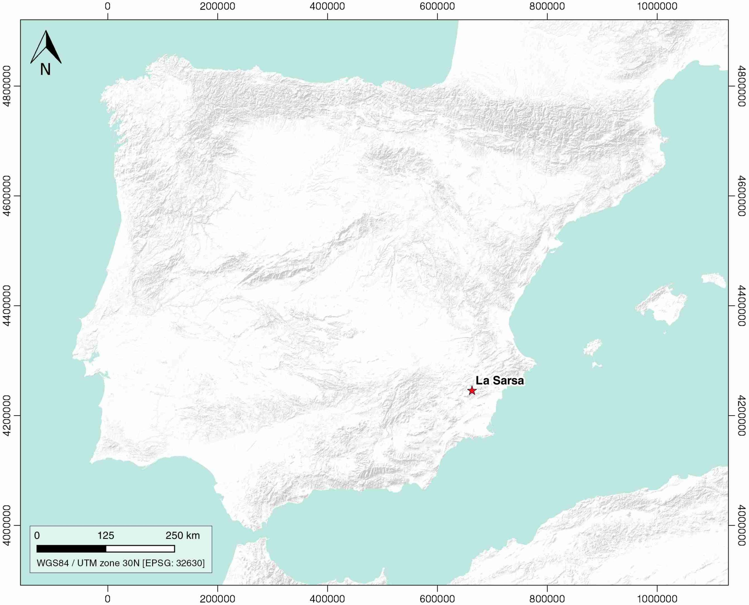
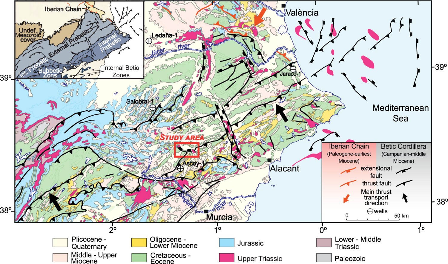
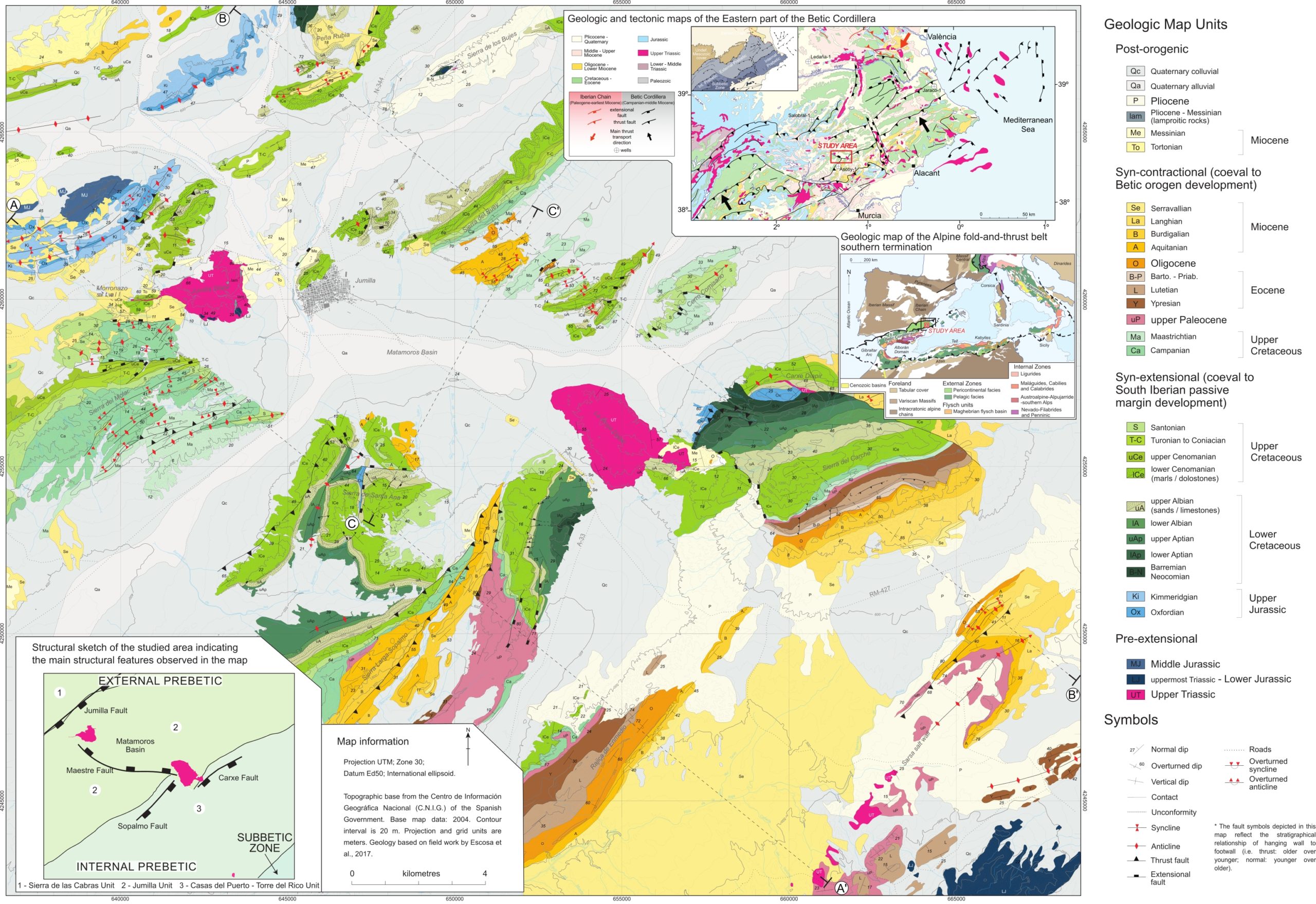
| Geological Setting | Betic system, Pre-Betic cordillera |
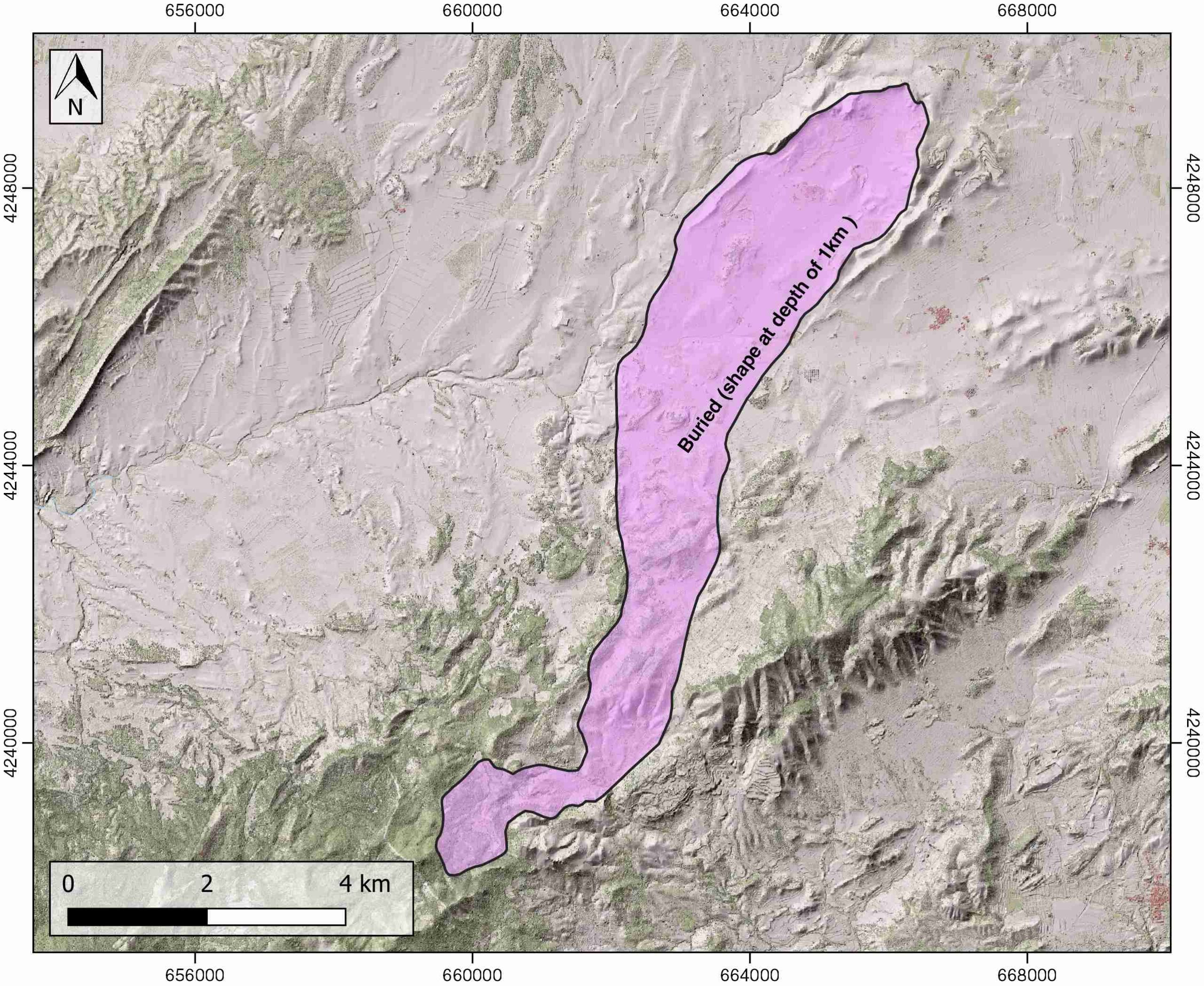
| Outcropping/buried | Buried |
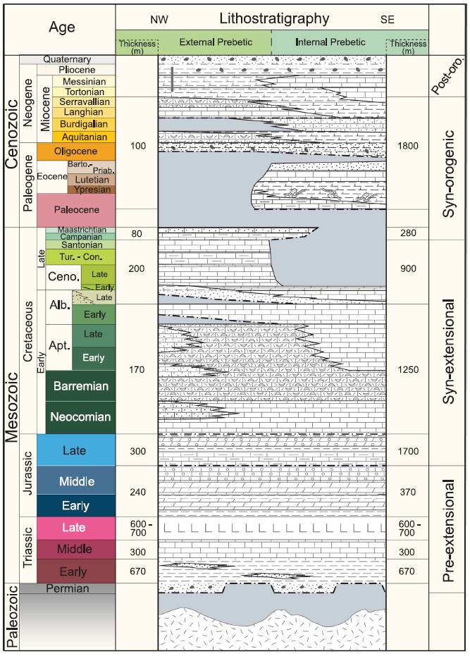
| Evaporite unit/s name | Keuper facies |
| Evaporite unit/s age | Carnian-Rhaetian (Upper Triassic) |
| Evaporite unit/s origin | Marine |
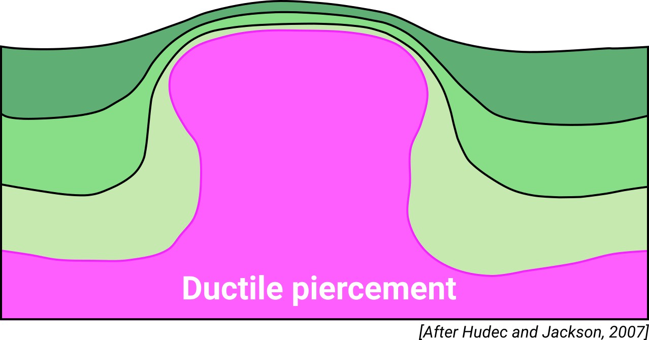
| Classif. (Hudec and Jackson, 2009) | Ductile piercement |
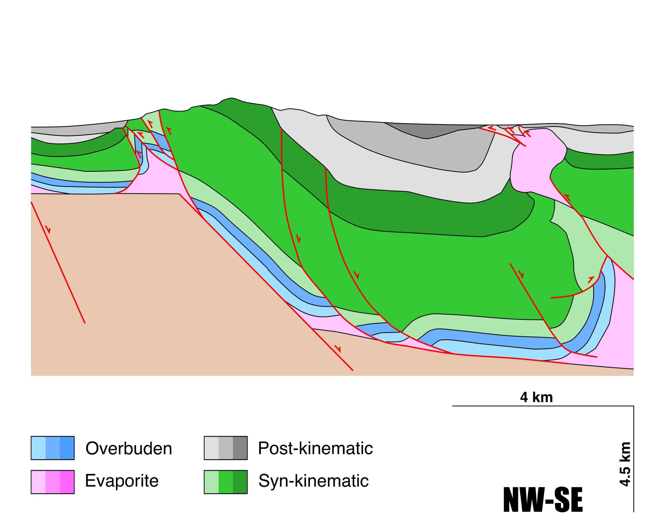
| Classif. (Jackson and Talbot, 1986) | Salt wall, Welded |
| Age of evaporite flow or deformation (when deformed) | Upper Jurassic to Lower Cretaceous |
| Other comments | Salt wall collapse and thrust-related welding from Late Maastrichtian time. |
Generic Data
| Unique ID | 77 |
| Name | La Sarsa |
| Structure type | Evaporite diapir |
| Deformed/Undeformed | Deformed |
| Buried/Outcropping | Buried |
| Geological setting | Betic System |
| Geological Regional Setting | Pre-Betic Cordillera |
| Evaporite unit/s name | Keuper facies |
| Evaporite unit/s age | Carnian-Rhaetian (Upper Triassic) |
| Evaporite unit/s era | Mesozoic |
| Evaporite unit/s origin | Marine |
| Evaporite unit/s composition | Gypsum-Shale-Marlstone-Ophites |
| Post-kinematic unit/s (or post-evaporite units when evaporites are undeformed) | Upper Palaeocene (limestones, mudstones, slumped sandstones) ; Eocene (marls and mudstones, limestones, calcarenites, sandstones) ; Oligocene (marls, mudstones, sandstones) ; Miocene (sandstones, mudstones, limestones, calcarenites) ; Pliocene-Quaternary (alluvial deposits) |
| Post-kinematic unit/s age (or post-evaporite units when evaporites are undeformed) | Palaeocene-Holocene |
| Classification (Hudec and Jackson, 2009) | Ductile piercement |
| Classification (Jackson and Talbot, 1986) | Salt wall |
| Mining activity? | Y |
| Mining activity start | – |
| Mining activity end | – |
| Mining galleries? | – |
| Mining products | Claystone |
| Mining sub-products | – |
| Evaporite flow? | Y |
| Age of evaporite flow | Upper Jurassic-Upper Albian |
| Flow or deformation triggering mechanisms | Extensional activity of the suprasalt faults |
| Flow-linked structures? | Y |
| Halokinetic structures | Low-angle unconformities / Normal high-angle faults / joints |
| Post-evaporite and pre-kinematic unit/s (overbuden) | Early Jurassic (mudstones, dolostones, marlstones) ; Middle Jurassic (dolostones, oolitic dolostones) |
| Syn-kinematic unit/s | Late Jurassic (limestones, dolostones, marlstones, oolitic dolostones, marly limestones) ; Neocomian (limestones, calcarenites) ; Barremian (bioclastic limestones) ; Early Aptian (limestones, calcarenites) ; Late Aptian-Upper Albian (dolostones) |
| Available seismic profiles | RV-6 / CZ-11 / RV-62 / RV-62 / CZ-10 / RV-14 / RV-62 / RV-5 / RV-62 / CZ9-1 / CZ-10 / RV-14 / RV-4 / RV-61 / CZ9-1 / CZ-11 / RV-6 / RV-76 / RV-62 / RV-60 / RV-5 |
| Available boreholes | SOLANA-2 / FUENTE BLANCA-2 / FUENTE BLANCA-1 / HOYA HERMOSA / SOLANA-1 / FUENTE BLANCA-1 / SOLANA-1 |
| Additional comments | Salt wall collapse and thrust-related welding from Late Maastrichtian time |
Mining Data
| UNIQUE_ID | 77 |
| Minning exploitations within <2km? | Y |
| Historical/Active | Active |
| Exploitation name #1 | LA PULGA |
| Exploitation ID (Spanish National Mining Cadastre) #1 | 22261 |
| Municipality #1 | Jumilla |
| Province #1 | MURCIA |
| Company #1 | LA LADRILLERA MURCIANA S.A. |
| Main minning Products #1 | Claystone |
| Exploitation name #2 | LA TORRE |
| Exploitation ID (Spanish National Mining Cadastre) #2 | 1037 |
| Municipality #2 | Jumilla |
| Province #2 | MURCIA |
| Company #2 | CERAMICAS BORJA S.A. |
| Main minning Products #2 | Claystone |
| Exploitation name #3 | RUBÍ |
| Exploitation ID (Spanish National Mining Cadastre) #3 | 1283 |
| Municipality #3 | Fortuna |
| Province #3 | MURCIA |
| Company #3 | LYM JAR NATURAL STONE, S.L. |
| Main minning Products #3 | Ornamental limestone |
Quantitative Data
| UNIQUE_ID | 77 |
| Outcropping area (km2) | Buried |
| Horizontal intersection area (km2) (when buried) | 19.55618 |
| Depth of intersection area (km2) (when buried) | 1 |
| Max. Width (Km) | 13.0706902 |
| Max. Length (Km) | 2.95909155 |
| Max. Evaporites thickness (km) | 1.8 |
| Max. Deformation age (Ma) | 157 |
| Min. Deformation age (Ma) | 100 |
| Deformation stages | 1 |
Reference Data
| UNIQUE_ID | 77 |
| Section source | Escosa, F.O., Roca, E., Ferrer, O., 2018. Testing thin-skinned inversion of a prerift salt-bearing passive margin (Eastern Prebetic Zone, SE Iberia). Journal of Structural Geology, 109, 55-73. [link] |
| Well / Borehole availability #1 | Escosa, F.O., Roca, E., Ferrer, O., 2018. Testing thin-skinned inversion of a prerift salt-bearing passive margin (Eastern Prebetic Zone, SE Iberia). Journal of Structural Geology, 109, 55-73. [link] |
| Well / Borehole availability #2 | n.a. |
| Available data (Stratigraphy) #1 | Escosa, F.O., Roca, E., Ferrer, O., 2018. Testing thin-skinned inversion of a prerift salt-bearing passive margin (Eastern Prebetic Zone, SE Iberia). Journal of Structural Geology, 109, 55-73. [link] |
| Available data (Stratigraphy) #2 | Guerrera, F., Mancheño, M.A., Martín-Martín, M., Raffaelli, G., Rodríguez-Estrella, T., Serrano, F., 2014. Paleogene evolution of the external betic zone and geodynamic implications. Geologica Acta, 12, 170–192. [link] |
| Available data (Stratigraphy) #3 | Arche, A., López-Gómez, J., García-Hidalgo, J. F., 2002. Control climático y eustático en depósitos del Carniense (Triásico Superior) del SE de la Peninsula Iberica. Journal of Iberian Geology, 28, 13-30. [link] |
| Available data (Stratigraphy) #4 | Vilas, L., Martín-Chivelet, J., Arias, C., 2003. Integration of subsidence and sequence stratigraphic analyses in the Cretaceous carbonate platforms of the Prebetic (Jumilla-Yecla Region), Spain. Palaeogeography, Palaeoclimatology, Palaeoecology, 200, 107-129. [link] |
| Available data (Stratigraphy) #5 | Rodríguez-Estrella, T., 1977. Síntesis geológica del Prebético de la provincia de Alicante. Boletín del Instituto Geológico y Minero de España 88, 183–214 and 273–299. [link] |
| Available data (Stratigraphy) #6 | Mancheño, M.A., Rodriguez-Estrella, T., 1985. Geología de los diapiros triásicos del nordeste de la provincia de Murcia. Estudios geológicos, 41, 189-200. [link] |
| Regional Stratigraphy | Escosa, F. O., Ferrer, O., Roca, E., 2018. Geology of the Eastern Prebetic Zone at the Jumilla region (SE Iberia). Journal of Maps, 14(2), 77-86. [link] |
| Seismic data availability #1 | Escosa, F.O., Roca, E., Ferrer, O., 2018. Testing thin-skinned inversion of a prerift salt-bearing passive margin (Eastern Prebetic Zone, SE Iberia). Journal of Structural Geology, 109, 55-73. [link] |
| Seismic data availability #2 | n.a. |
| Seismic data availability #3 | n.a. |
| Available data (Structure) #1 | Escosa, F.O., Roca, E., Ferrer, O., 2018. Testing thin-skinned inversion of a prerift salt-bearing passive margin (Eastern Prebetic Zone, SE Iberia). Journal of Structural Geology, 109, 55-73. [link] |
| Available data (Structure) #2 | Navarro-Hervás, F., Rodríguez-Estrella, T., 1985. Características morfoestructurales de los diapiros triásicos de Hellín, Ontur, la Celia, Jumilla, La Rosa y Pinoso, en las provincias de Albacete, Murcia y Alicante. Papeles de geografía, 10, 49-69. [link] |
| Available data (Structure) #3 | Guerrera, F., Mancheño, M.A., Martín-Martín, M., Raffaelli, G., Rodríguez-Estrella, T., Serrano, F., 2014. Paleogene evolution of the external betic zone and geodynamic implications. Geologica Acta, 12, 170–192. [link] |
| Available data (Structure) #4 | Roca, E., Sans, M., Koyi, H.A., 2006. Polyphase deformation of diapiric areas in models and in the eastern Prebetics (Spain). AAPG Bulletin, 90, 115-136. [link] |
| Available data (Structure) #5 | Mancheño, M.A., Rodriguez-Estrella, T., 1985. Geología de los diapiros triásicos del nordeste de la provincia de Murcia. Estudios geológicos, 41, 189-200. [link] |
| Available data (Structure) #6 | Escosa, F. O., Ferrer, O., Roca, E., 2018. Geology of the Eastern Prebetic Zone at the Jumilla region (SE Iberia). Journal of Maps, 14(2), 77-86. [link] |
| Available data (Analogue modelling) #1 | n.a. |
| Available data (Analogue modelling) #2 | n.a. |
| Available data (Analogue modelling) #3 | n.a. |
| Available data (Gravimetry – Tomography) #1 | Escosa, F.O., Roca, E., Ferrer, O., 2018. Testing thin-skinned inversion of a prerift salt-bearing passive margin (Eastern Prebetic Zone, SE Iberia). Journal of Structural Geology, 109, 55-73. [link] |
| Available data (Gravimetry – Tomography) #2 | Castaño, S., Carbó, A., 1995. Los afloramientos triásicos de la zona de confluencia de las Cordilleras Ibérica y Bética. Aportes de la gravimetría a su interpretación. Cuadernos de Geología Ibérica, 19, 235-248. [link] |
| Available data (Gravimetry – Tomography) #3 | Castaño-Fernández, S., 1993. La estructura cortical del area de unión de las cordilleras Ibérica y Béticas. Interpretación geotectónica basada en datos gravimétricos. PhD thesis, Universidad Complutense de Madrid, Madrid. [link] |
| Available data (Geochemistry) #1 | Ortí, F., García-Veigas, J., Rossell, L., Jurado, M. J., Utrilla, R., 1996. Formaciones salinas de las cuencas triásicas en la Península Ibérica: Caracterización Petrológica y Geoquímica. Cuadernos de Geología Ibérica, 20, 13-35. [link] |
| Available data (Geochemistry) #2 | n.a. |
| Available data (Geochemistry) #3 | n.a. |
| Available data (Geochemistry) #4 | n.a. |
| Available data (Petrophysics) #1 | n.a. |
| Available data (Petrophysics) #2 | n.a. |
| IGME Geological Map (MAGNA50) Sheet number | 892-Fortuna. [link] |
| Other Maps #1 (source) | Escosa, F. O., Ferrer, O., Roca, E., 2018. Geology of the Eastern Prebetic Zone at the Jumilla region (SE Iberia). Journal of Maps, 14(2), 77-86. [link] |
| Other Maps #2 (source) | Escosa, F. O., Ferrer, O., Roca, E., 2018. Geology of the Eastern Prebetic Zone at the Jumilla region (SE Iberia). Journal of Maps, 14(2), 77-86. [link] |
| Other related references #1 | Rodríguez-Estrella, T., 1983. Neotectónica relacionada con las estructuras diapíricas en el Sureste de la Península Ibérica. Tecniterrae, 9, 14-30. [link] |
| Other related references #2 | Ortí, F. C., 1990. El domo de Pinoso, La sal del domo de La Rosa y el domo de Jumilla Formaciones evaporíticas de la Cuenca del Ebro y Cadenas periféricas, y de la zona de Levante. Ortí y Salvany (Eds.) ENRESAGPPG. Barcelona: 289-291 (Unpublished) |
| Other related references #3 | Ortí, F. C., 1974. El Keuper del Levante español. Estudios Geológicos, 30, 7- 46. [link] |
| Other related references #4 | Ortí, F. C., 1987. Aspectos sedimentológicos de las evaporitas del Triásico y del Liásico inferior en el Este de la Península Ibérica. Cuadernos de Geología Ibérica 11, 837-858. [link] |
Well and Seismic Data
| UNIQUE_ID | 77 |
| Seismic survey name #1 | 9I2-RV |
| Across structure? #1 | Y |
| Seismic profile ID (IGME) #1 | 10947 |
| Seismic profile code #1 | 15586 |
| Seismic profile name #1 | RV-6 |
| Seismic survey year #1 | 1985 |
| Data repository #1 | SIGEOF Data Catalogue (Section available under request). ©Instituto Geológico y Minero de España (IGME). https://info.igme.es/SIGEOF/ |
| Length (km) #1 | 27.60 |
| Seismic survey name #2 | 9I-ST-26 |
| Across structure? #2 | Y |
| Seismic profile ID (IGME) #2 | 13792 |
| Seismic profile code #2 | 18513 |
| Seismic profile name #2 | CZ-11 |
| Seismic survey year #2 | 1964 |
| Data repository #2 | SIGEOF Data Catalogue (Section available under request). ©Instituto Geológico y Minero de España (IGME). https://info.igme.es/SIGEOF/ |
| Length (km) #2 | 9.49 |
| Seismic survey name #3 | 0362A84U |
| Across structure? #3 | Y |
| Seismic profile ID (IGME) #3 | 4588 |
| Seismic profile code #3 | 6255 |
| Seismic profile name #3 | RV-62 |
| Seismic survey year #3 | 1984 |
| Data repository #3 | SIGEOF Data Catalogue (Private access section). ©Instituto Geológico y Minero de España (IGME). https://info.igme.es/SIGEOF/ |
| Length (km) #3 | 39.69 |
| Seismic survey name #4 | 0362A84G |
| Across structure? #4 | Y |
| Seismic profile ID (IGME) #4 | 4483 |
| Seismic profile code #4 | 6150 |
| Seismic profile name #4 | RV-62 |
| Seismic survey year #4 | 1984 |
| Data repository #4 | SIGEOF Data Catalogue (Private access section). ©Instituto Geológico y Minero de España (IGME). https://info.igme.es/SIGEOF/ |
| Length (km) #4 | 12.55 |
| Seismic survey name #5 | 9I-ST-26 |
| Across structure? #5 | Y |
| Seismic profile ID (IGME) #5 | 13793 |
| Seismic profile code #5 | 18514 |
| Seismic profile name #5 | CZ-10 |
| Seismic survey year #5 | 1964 |
| Data repository #5 | SIGEOF Data Catalogue (Section available under request). ©Instituto Geológico y Minero de España (IGME). https://info.igme.es/SIGEOF/ |
| Length (km) #5 | 18.03 |
| Seismic survey name #6 | 9I2-RV |
| Across structure? #6 | Y |
| Seismic profile ID (IGME) #6 | 10952 |
| Seismic profile code #6 | 15591 |
| Seismic profile name #6 | RV-14 |
| Seismic survey year #6 | 1985 |
| Data repository #6 | SIGEOF Data Catalogue (Section available under request). ©Instituto Geológico y Minero de España (IGME). https://info.igme.es/SIGEOF/ |
| Length (km) #6 | 35.22 |
| Seismic survey name #7 | 0362A84S |
| Across structure? #7 | Y |
| Seismic profile ID (IGME) #7 | 4546 |
| Seismic profile code #7 | 6213 |
| Seismic profile name #7 | RV-62 |
| Seismic survey year #7 | 1984 |
| Data repository #7 | SIGEOF Data Catalogue (Private access section). ©Instituto Geológico y Minero de España (IGME). https://info.igme.es/SIGEOF/ |
| Length (km) #7 | 20.89 |
| Seismic survey name #8 | 9I2-RV |
| Across structure? #8 | Y |
| Seismic profile ID (IGME) #8 | 10950 |
| Seismic profile code #8 | 15589 |
| Seismic profile name #8 | RV-5 |
| Seismic survey year #8 | 1985 |
| Data repository #8 | SIGEOF Data Catalogue (Section available under request). ©Instituto Geológico y Minero de España (IGME). https://info.igme.es/SIGEOF/ |
| Length (km) #8 | 25.40 |
| Seismic survey name #9 | 9I2-RV |
| Across structure? #9 | Y |
| Seismic profile ID (IGME) #9 | 10944 |
| Seismic profile code #9 | 15583 |
| Seismic profile name #9 | RV-62 |
| Seismic survey year #9 | 1985 |
| Data repository #9 | SIGEOF Data Catalogue (Section available under request). ©Instituto Geológico y Minero de España (IGME). https://info.igme.es/SIGEOF/ |
| Length (km) #9 | 26.20 |
| Seismic survey name #10 | 9I-ST-26 |
| Across structure? #10 | Y |
| Seismic profile ID (IGME) #10 | 13782 |
| Seismic profile code #10 | 18503 |
| Seismic profile name #10 | CZ9-1 |
| Seismic survey year #10 | 1964 |
| Data repository #10 | SIGEOF Data Catalogue (Section available under request). ©Instituto Geológico y Minero de España (IGME). https://info.igme.es/SIGEOF/ |
| Length (km) #10 | 4.24 |
| Seismic survey name #11 | 9I-ST-26 |
| Across structure? #11 | N (within 3km) |
| Seismic profile ID (IGME) #11 | 13793 |
| Seismic profile code #11 | 18514 |
| Seismic profile name #11 | CZ-10 |
| Seismic survey year #11 | 1964 |
| Data repository #11 | SIGEOF Data Catalogue (Section available under request). ©Instituto Geológico y Minero de España (IGME). https://info.igme.es/SIGEOF/ |
| Length (km) #11 | 18.03 |
| Seismic survey name #12 | 9I2-RV |
| Across structure? #12 | N (within 3km) |
| Seismic profile ID (IGME) #12 | 10952 |
| Seismic profile code #12 | 15591 |
| Seismic profile name #12 | RV-14 |
| Seismic survey year #12 | 1985 |
| Data repository #12 | SIGEOF Data Catalogue (Section available under request). ©Instituto Geológico y Minero de España (IGME). https://info.igme.es/SIGEOF/ |
| Length (km) #12 | 35.22 |
| Seismic survey name #13 | 9I2-RV |
| Across structure? #13 | N (within 3km) |
| Seismic profile ID (IGME) #13 | 10951 |
| Seismic profile code #13 | 15590 |
| Seismic profile name #13 | RV-4 |
| Seismic survey year #13 | 1985 |
| Data repository #13 | SIGEOF Data Catalogue (Section available under request). ©Instituto Geológico y Minero de España (IGME). https://info.igme.es/SIGEOF/ |
| Length (km) #13 | 30.51 |
| Seismic survey name #14 | 9I2-RV |
| Across structure? #14 | N (within 3km) |
| Seismic profile ID (IGME) #14 | 10945 |
| Seismic profile code #14 | 15584 |
| Seismic profile name #14 | RV-61 |
| Seismic survey year #14 | 1985 |
| Data repository #14 | SIGEOF Data Catalogue (Section available under request). ©Instituto Geológico y Minero de España (IGME). https://info.igme.es/SIGEOF/ |
| Length (km) #14 | 20.86 |
| Seismic survey name #15 | 9I-ST-26 |
| Across structure? #15 | N (within 3km) |
| Seismic profile ID (IGME) #15 | 13782 |
| Seismic profile code #15 | 18503 |
| Seismic profile name #15 | CZ9-1 |
| Seismic survey year #15 | 1964 |
| Data repository #15 | SIGEOF Data Catalogue (Section available under request). ©Instituto Geológico y Minero de España (IGME). https://info.igme.es/SIGEOF/ |
| Length (km) #15 | 4.24 |
| Seismic survey name #16 | 9I-ST-26 |
| Across structure? #16 | N (within 3km) |
| Seismic profile ID (IGME) #16 | 13792 |
| Seismic profile code #16 | 18513 |
| Seismic profile name #16 | CZ-11 |
| Seismic survey year #16 | 1964 |
| Data repository #16 | SIGEOF Data Catalogue (Section available under request). ©Instituto Geológico y Minero de España (IGME). https://info.igme.es/SIGEOF/ |
| Length (km) #16 | 9.49 |
| Seismic survey name #17 | 9I2-RV |
| Across structure? #17 | N (within 3km) |
| Seismic profile ID (IGME) #17 | 10947 |
| Seismic profile code #17 | 15586 |
| Seismic profile name #17 | RV-6 |
| Seismic survey year #17 | 1985 |
| Data repository #17 | SIGEOF Data Catalogue (Section available under request). ©Instituto Geológico y Minero de España (IGME). https://info.igme.es/SIGEOF/ |
| Length (km) #17 | 27.60 |
| Seismic survey name #18 | 9I2-RV |
| Across structure? #18 | N (within 3km) |
| Seismic profile ID (IGME) #18 | 10940 |
| Seismic profile code #18 | 15579 |
| Seismic profile name #18 | RV-76 |
| Seismic survey year #18 | 1985 |
| Data repository #18 | SIGEOF Data Catalogue (Section available under request). ©Instituto Geológico y Minero de España (IGME). https://info.igme.es/SIGEOF/ |
| Length (km) #18 | 21.25 |
| Seismic survey name #19 | 9I2-RV |
| Across structure? #19 | N (within 3km) |
| Seismic profile ID (IGME) #19 | 10944 |
| Seismic profile code #19 | 15583 |
| Seismic profile name #19 | RV-62 |
| Seismic survey year #19 | 1985 |
| Data repository #19 | SIGEOF Data Catalogue (Section available under request). ©Instituto Geológico y Minero de España (IGME). https://info.igme.es/SIGEOF/ |
| Length (km) #19 | 26.20 |
| Seismic survey name #20 | 9I2-RV |
| Across structure? #20 | N (within 3km) |
| Seismic profile ID (IGME) #20 | 10946 |
| Seismic profile code #20 | 15585 |
| Seismic profile name #20 | RV-60 |
| Seismic survey year #20 | 1985 |
| Data repository #20 | SIGEOF Data Catalogue (Section available under request). ©Instituto Geológico y Minero de España (IGME). https://info.igme.es/SIGEOF/ |
| Length (km) #20 | 66.32 |
| Seismic survey name #21 | 9I2-RV |
| Across structure? #21 | N (within 3km) |
| Seismic profile ID (IGME) #21 | 10950 |
| Seismic profile code #21 | 15589 |
| Seismic profile name #21 | RV-5 |
| Seismic survey year #21 | 1985 |
| Data repository #21 | SIGEOF Data Catalogue (Section available under request). ©Instituto Geológico y Minero de España (IGME). https://info.igme.es/SIGEOF/ |
| Length (km) #21 | 25.40 |
| Borehole name #1 | SOLANA-2 |
| Company #1 | TRAGSA |
| Traget #1 | HYDROGEOLOGY |
| Across structure? #1 | N (within 5 km) |
| Borehole name #2 | FUENTE BLANCA-2 |
| Company #2 | TRAGSA |
| Traget #2 | HYDROGEOLOGY |
| Across structure? #2 | N (within 5 km) |
| Borehole name #3 | FUENTE BLANCA-1 |
| Company #3 | TRAGSA |
| Traget #3 | HYDROGEOLOGY |
| Across structure? #3 | N (within 5 km) |
| Borehole name #4 | HOYA HERMOSA |
| Company #4 | TRAGSA |
| Traget #4 | HYDROGEOLOGY |
| Across structure? #4 | N (within 5 km) |
| Borehole name #5 | SOLANA-1 |
| Company #5 | TRAGSA |
| Traget #5 | HYDROGEOLOGY |
| Across structure? #5 | N (within 5 km) |
| Borehole name #6 | FUENTE BLANCA-1 |
| Company #6 | TRAGSA |
| Traget #6 | HYDROGEOLOGY |
| Across structure? #6 | N (within 5 km) |
| Borehole name #7 | SOLANA-1 |
| Company #7 | TRAGSA |
| Traget #7 | HYDROGEOLOGY |
| Across structure? #7 | N (within 5 km) |
| Borehole name #8 | |
| Company #8 | |
| Traget #8 | |
| Across structure? #8 | |
| Borehole name #9 | |
| Company #9 | |
| Traget #9 | |
| Across structure? #9 | |
| Borehole name #10 | |
| Company #10 | |
| Traget #10 | |
| Across structure? #10 | |
| Borehole name #11 | |
| Company #11 | |
| Traget #11 | |
| Across structure? #11 | |
| Borehole name #12 | |
| Company #12 | |
| Traget #12 | |
| Across structure? #12 | |
| Borehole name #13 | |
| Company #13 | |
| Traget #13 | |
| Across structure? #13 | |
| Borehole name #14 | |
| Company #14 | |
| Traget #14 | |
| Across structure? #14 | |
| Borehole name #15 | |
| Company #15 | |
| Traget #15 | |
| Across structure? #15 |
Geographical Data (EPSG:4326 - WGS 84)
| UNIQUE_ID | 77 |
| X Centroid (Structure shape) | -1.131501 |
| Y Centroid (Structure shape) | -1.131501 |
| Xmin (Structure shape) | -1.176722 |
| Xmax (Structure shape) | -1.093109 |
| Ymin (Structure shape) | 38.276644 |
| Ymax (Structure shape) | 38.378311 |
| Xmin seismic line #1 | -1.167243 |
| Xmax seismic line #1 | -1.046837 |
| Ymin seismic line #1 | 38.238121 |
| Ymax seismic line #1 | 38.467905 |
| Xmin seismic line #2 | -1.172625 |
| Xmax seismic line #2 | -1.136337 |
| Ymin seismic line #2 | 38.260717 |
| Ymax seismic line #2 | 38.317599 |
| Xmin seismic line #3 | -1.270799 |
| Xmax seismic line #3 | -1.022682 |
| Ymin seismic line #3 | 38.304117 |
| Ymax seismic line #3 | 38.433816 |
| Xmin seismic line #4 | -1.143240 |
| Xmax seismic line #4 | -1.030321 |
| Ymin seismic line #4 | 38.311758 |
| Ymax seismic line #4 | 38.379508 |
| Xmin seismic line #5 | -1.188970 |
| Xmax seismic line #5 | -1.135873 |
| Ymin seismic line #5 | 38.187677 |
| Ymax seismic line #5 | 38.313306 |
| Xmin seismic line #6 | -1.191101 |
| Xmax seismic line #6 | -0.836396 |
| Ymin seismic line #6 | 38.328088 |
| Ymax seismic line #6 | 38.478639 |
| Xmin seismic line #7 | -1.259577 |
| Xmax seismic line #7 | -1.085128 |
| Ymin seismic line #7 | 38.348841 |
| Ymax seismic line #7 | 38.432595 |
| Xmin seismic line #8 | -1.264222 |
| Xmax seismic line #8 | -1.123790 |
| Ymin seismic line #8 | 38.262455 |
| Ymax seismic line #8 | 38.462616 |
| Xmin seismic line #9 | -1.268112 |
| Xmax seismic line #9 | -1.022954 |
| Ymin seismic line #9 | 38.303565 |
| Ymax seismic line #9 | 38.436063 |
| Xmin seismic line #10 | -1.180100 |
| Xmax seismic line #10 | -1.137294 |
| Ymin seismic line #10 | 38.300653 |
| Ymax seismic line #10 | 38.315358 |
| Xmin seismic line #11 | -1.188970 |
| Xmax seismic line #11 | -1.135873 |
| Ymin seismic line #11 | 38.187677 |
| Ymax seismic line #11 | 38.313306 |
| Xmin seismic line #12 | -1.191101 |
| Xmax seismic line #12 | -0.836396 |
| Ymin seismic line #12 | 38.328088 |
| Ymax seismic line #12 | 38.478639 |
| Xmin seismic line #13 | -1.432544 |
| Xmax seismic line #13 | -1.173041 |
| Ymin seismic line #13 | 38.241380 |
| Ymax seismic line #13 | 38.424898 |
| Xmin seismic line #14 | -1.357534 |
| Xmax seismic line #14 | -1.182235 |
| Ymin seismic line #14 | 38.293293 |
| Ymax seismic line #14 | 38.420365 |
| Xmin seismic line #15 | -1.180100 |
| Xmax seismic line #15 | -1.137294 |
| Ymin seismic line #15 | 38.300653 |
| Ymax seismic line #15 | 38.315358 |
| Xmin seismic line #16 | -1.172625 |
| Xmax seismic line #16 | -1.136337 |
| Ymin seismic line #16 | 38.260717 |
| Ymax seismic line #16 | 38.317599 |
| Xmin seismic line #17 | -1.167243 |
| Xmax seismic line #17 | -1.046837 |
| Ymin seismic line #17 | 38.238121 |
| Ymax seismic line #17 | 38.467905 |
| Xmin seismic line #18 | -1.362022 |
| Xmax seismic line #18 | -1.167791 |
| Ymin seismic line #18 | 38.344262 |
| Ymax seismic line #18 | 38.458465 |
| Xmin seismic line #19 | -1.268112 |
| Xmax seismic line #19 | -1.022954 |
| Ymin seismic line #19 | 38.303565 |
| Ymax seismic line #19 | 38.436063 |
| Xmin seismic line #20 | -1.246637 |
| Xmax seismic line #20 | -0.614979 |
| Ymin seismic line #20 | 38.314487 |
| Ymax seismic line #20 | 38.640693 |
| Xmin seismic line #21 | -1.264222 |
| Xmax seismic line #21 | -1.123790 |
| Ymin seismic line #21 | 38.262455 |
| Ymax seismic line #21 | 38.462616 |
| X borehole #1 | -1.047676 |
| Y borehole #1 | 38.348980 |
| X borehole #2 | -1.158801 |
| Y borehole #2 | 38.256159 |
| X borehole #3 | -1.158801 |
| Y borehole #3 | 38.256159 |
| X borehole #4 | -1.146017 |
| Y borehole #4 | 38.264518 |
| X borehole #5 | -1.048564 |
| Y borehole #5 | 38.342327 |
| X borehole #6 | -1.158801 |
| Y borehole #6 | 38.256159 |
| X borehole #7 | -1.048564 |
| Y borehole #7 | 38.342327 |
| X borehole #8 | |
| Y borehole #8 | |
| X borehole #9 | |
| Y borehole #9 | |
| X borehole #10 | |
| Y borehole #10 | |
| X borehole #11 | |
| Y borehole #11 | |
| X borehole #12 | |
| Y borehole #12 | |
| X borehole #13 | |
| Y borehole #13 | |
| X borehole #14 | |
| Y borehole #14 | |
| X borehole #15 | |
| Y borehole #15 |

