General Information
| Structure type | Evaporite Diapir |
| Deformed/Undeformed | Deformed |
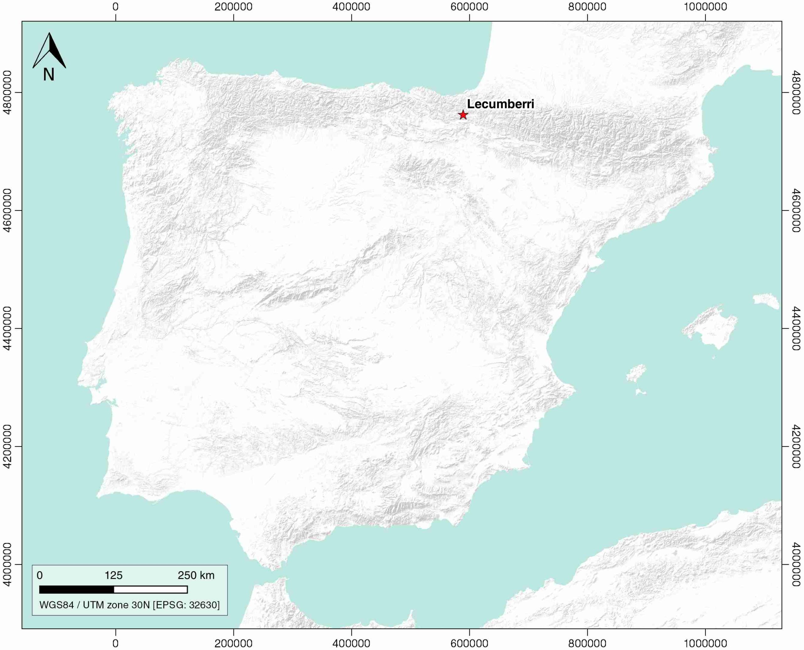
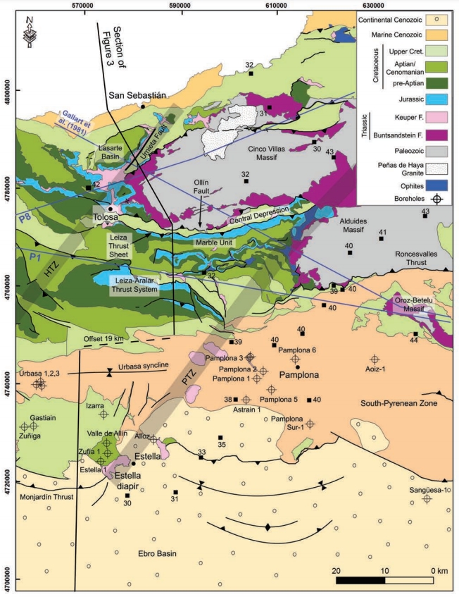
| Geological Setting | Basque-Cantabrian Basin, Navarra-Álava trough |
| Outcropping/buried | Outcropping |
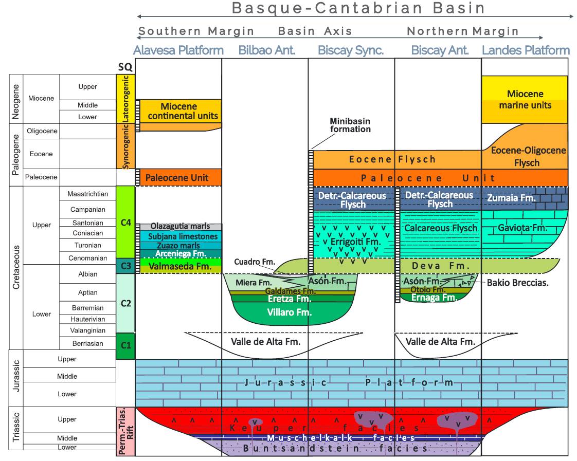
| Evaporite unit/s name | Keuper facies |
| Evaporite unit/s age | Carnian-Rhaetian (Upper Triassic) |
| Evaporite unit/s origin | Marine |
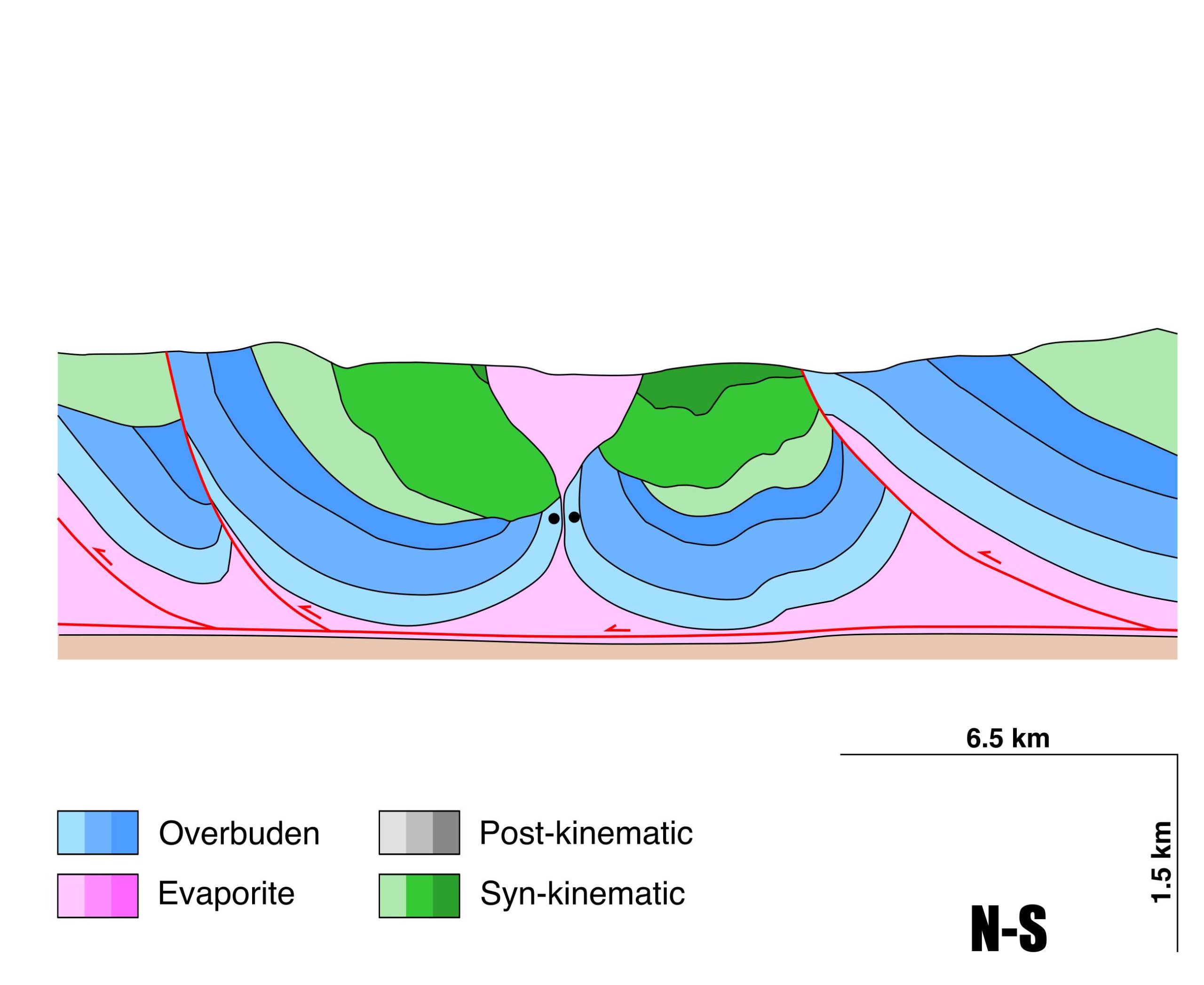
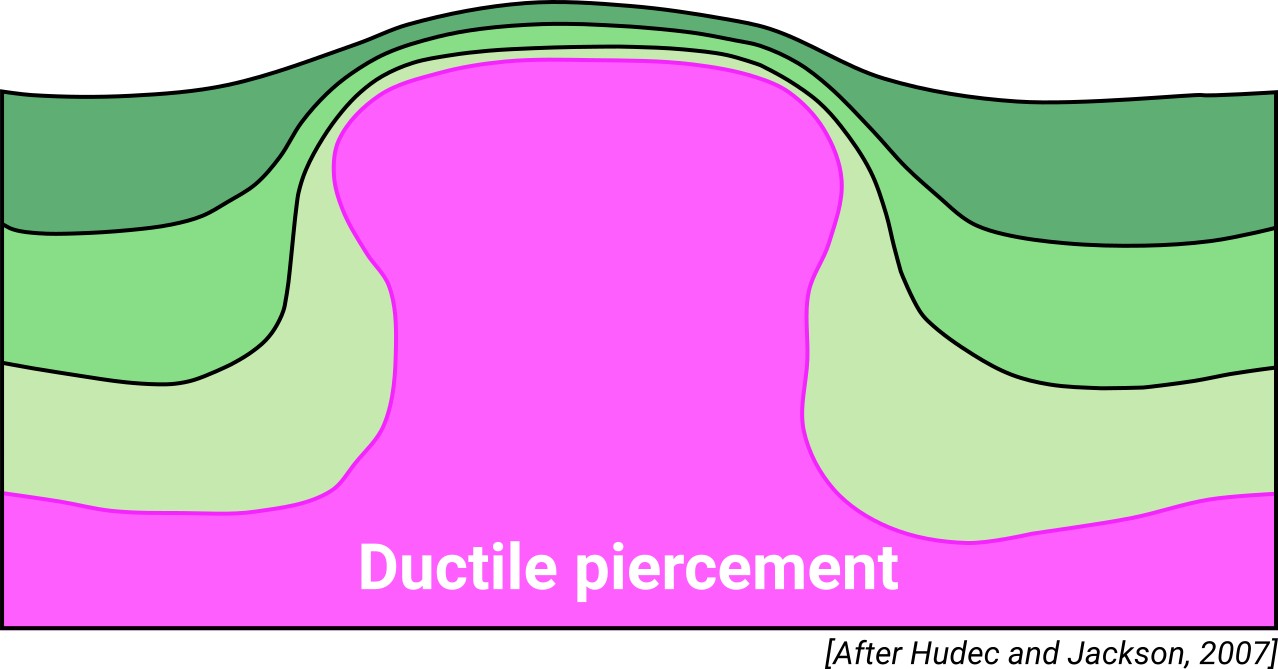
| Classif. (Hudec and Jackson, 2009) | Ductile piercement |
| Classif. (Jackson and Talbot, 1986) | Salt wall |
| Age of evaporite flow or deformation (when deformed) | Upper Jurassic to Upper Cretaceous |
| Other comments | Salt motion lasted until syn-orogenic times, as the Maastrichtian layers are also affected by diapirs (see Ducoux et al., 2020). |
Generic Data
| Unique ID | 39 |
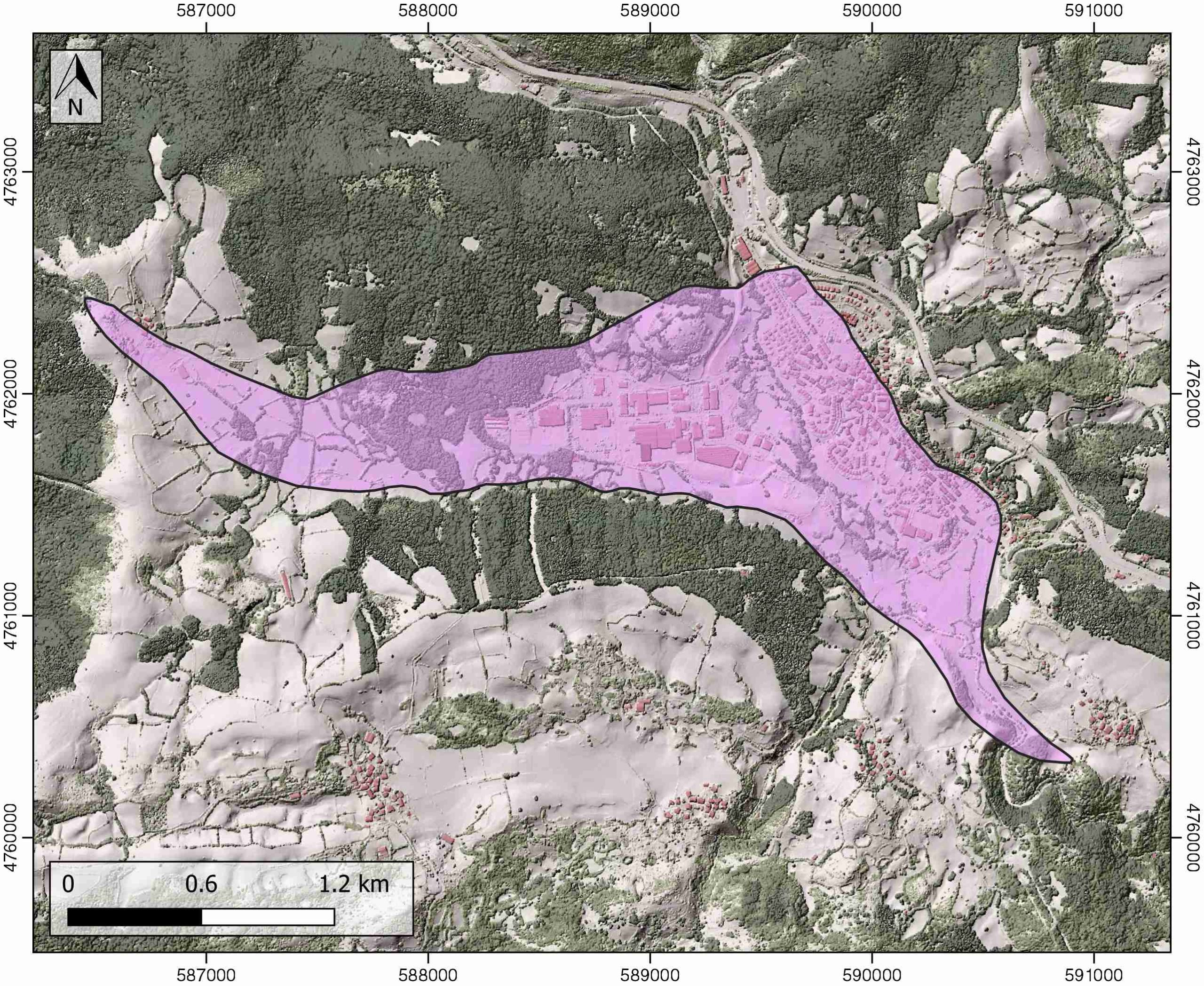
| Name | Lecumberri |
| Structure type | Evaporite diapir |
| Deformed/Undeformed | Deformed |
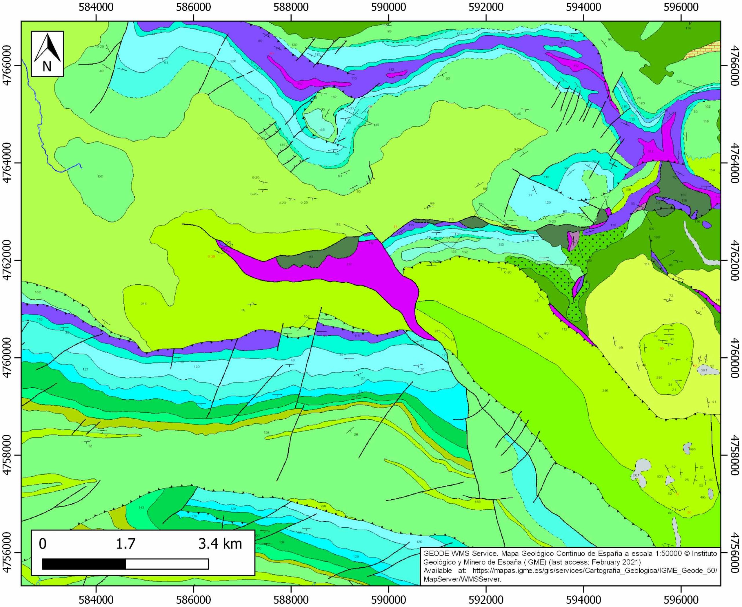
| Buried/Outcropping | Outcropping |
| Geological setting | Basque-Cantabrian Basin |
| Geological Regional Setting | Navarra-Álava trough |
| Evaporite unit/s name | Keuper facies |
| Evaporite unit/s age | Carnian-Rhaetian (Upper Triassic) |
| Evaporite unit/s era | Mesozoic |
| Evaporite unit/s origin | Marine |
| Evaporite unit/s composition | Gypsum-Halite-Anhydrite-Claystone-Ophites |
| Post-kinematic unit/s (or post-evaporite units when evaporites are undeformed) | Quaternary (alluvial and colluvial detrital deposits) |
| Post-kinematic unit/s age (or post-evaporite units when evaporites are undeformed) | Pleistocene-Holocene |
| Classification (Hudec and Jackson, 2009) | Ductile piercement |
| Classification (Jackson and Talbot, 1986) | Salt wall |
| Mining activity? | Y |
| Mining activity start | 19th century |
| Mining activity end | 1988 |
| Mining galleries? | Y |
| Mining products | Pb-Zn |
| Mining sub-products | – |
| Evaporite flow? | Y |
| Age of evaporite flow | Late Jurassic – Maastrichtian |
| Flow or deformation triggering mechanisms | Mesozoic extensional regime in the Basque–Cantabrian Basin (Lowe Cretaceous, listric faults and salt tectonics) followed by Iberian plate drifting and tectonic inversion (Upper Cretaceous) |
| Flow-linked structures? | Y |
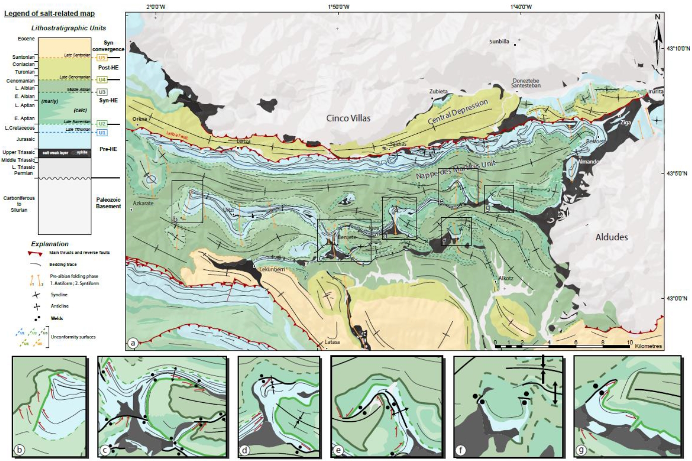
| Halokinetic structures | Normal high-angle faults / joints / thickness variations / progressive unconformities |
| Post-evaporite and pre-kinematic unit/s (overbuden) | Jurassic (limestones, dolostones, oolitic limestones, marls) |
| Syn-kinematic unit/s | Valanginian – Barremian (Weald facies, limestones, clays and sandstones) / Aptian – Albian (limestones, marls, sandstones and lutites) / Cenomanian – Maastrichtian (shales, marls and limestones) |
| Available seismic profiles | 21 |
| Available boreholes | |
| Additional comments | Salt motion lasted until syn-orogenic times, as the Maastrichtian layers are also affected by diapirs (see Ducoux et al., 2020). |
Mining Data
| UNIQUE_ID | 39 |
| Minning exploitations within <2km? | Y |
| Historical/Active | Historical (not indexed in the Spanish National Minning Cadastre) |
| Exploitation name #1 | n.a. |
| Exploitation ID (Spanish National Mining Cadastre) #1 | n.a. |
| Municipality #1 | n.a. |
| Province #1 | n.a. |
| Company #1 | n.a. |
| Main minning Products #1 | Pb-Zn |
| Exploitation name #2 | |
| Exploitation ID (Spanish National Mining Cadastre) #2 | |
| Municipality #2 | |
| Province #2 | |
| Company #2 | |
| Main minning Products #2 | |
| Exploitation name #3 | |
| Exploitation ID (Spanish National Mining Cadastre) #3 | |
| Municipality #3 | |
| Province #3 | |
| Company #3 | |
| Main minning Products #3 |
Quantitative Data
| UNIQUE_ID | 39 |
| Outcropping area (km2) | 2.82377 |
| Horizontal intersection area (km2) (when buried) | Not buried |
| Depth of intersection area (km2) (when buried) | Not buried |
| Max. Width (Km) | 4.8 |
| Max. Length (Km) | 1.9 |
| Max. Evaporites thickness (km) | 1.2 |
| Max. Deformation age (Ma) | 150 |
| Min. Deformation age (Ma) | 66 |
| Deformation stages | 1 |
Reference Data
| UNIQUE_ID | 39 |
| Section source | Ducoux, M., Jolivet, L., Callot, J. P., Aubourg, C., Masini, E., Lahfid, A., Hommonay, E., Cagnard, F., Gumiaux, C., Baudin, T., 2019. The Nappe des Marbres unit of the Basque‐Cantabrian Basin: the tectono‐thermal evolution of a fossil hyperextended rift basin. Tectonics, 38(11), 3881-3915. [link] |
| Well / Borehole availability #1 | n.a. |
| Well / Borehole availability #2 | n.a. |
| Available data (Stratigraphy) #1 | Ducoux, M., Jolivet, L., Callot, J. P., Aubourg, C., Masini, E., Lahfid, A., Hommonay, E., Cagnard, F., Gumiaux, C., Baudin, T., 2019. The Nappe des Marbres unit of the Basque‐Cantabrian Basin: the tectono‐thermal evolution of a fossil hyperextended rift basin. Tectonics, 38(11), 3881-3915. [link] |
| Available data (Stratigraphy) #2 | Bodego, A., Iriarte, E., López-Horgue, M. A., Álvarez, I., 2018. Rift-margin extensional forced folds and salt tectonics in the eastern Basque-Cantabrian rift basin (western Pyrenees). Marine and Petroleum Geology, 91, 667-682. [link] |
| Available data (Stratigraphy) #3 | Küchler, T., 1998. Upper Cretaceous of the Barranca (Navarra, northern Spain); integrated itho-, bio- and event stratigraphy. Part I: Cenomanian through Santonian. Acta Geologica Polonica, 48 (2), 157-180. [link] |
| Available data (Stratigraphy) #4 | García-Mondejar, J., Aguirrezabalaga, L.M., Aramburu, A., Fernandez-Mendiola, P.A., Gomez-Perez, I., Lopez-Horgue, M., Corrales, I., 1996. Aptian-albian tectonic pattern of the Basque-Cantabrian basin (Northern Spain). Geological Journal, 31, 13-45. [link] |
| Available data (Stratigraphy) #5 | Soler, R., 1971. El Jurásico Marino de la Sierra de Aralar (Cuenca Cantábrica occidental): Los problemas poskinméricos. Cuadernos de Geología Ibérica, 2, 509-532. [link] |
| Available data (Stratigraphy) #6 | Bodego, A., Iriarte, E., Agirrezabala, L. M., García-Mondéjar, J., López-Horgue, M. A., 2015. Synextensional mid-Cretaceous stratigraphic architecture of the eastern Basque–Cantabrian basin margin (western Pyrenees). Cretaceous Research, 55, 229-261. [link] |
| Regional Stratigraphy | Pedrera, A., García‐Senz, J., Ayala, C., Ruiz‐Constán, A., Rodríguez‐Fernández, L. R., Robador, A., González Menéndez, L., 2017. Reconstruction of the exhumed mantle across the North Iberian Margin by crustal‐scale 3‐D gravity inversion and geological cross section. Tectonics, 36, 3155-3177. [link] |
| Seismic data availability #1 | DeFelipe, I., Álvarez Pulgar, F. J., Pedreira Rodríguez, D., 2018. Crustal structure of the Eastern Basque-Cantabrian Zone-western Pyrenees: from the Cretaceous hyperextension to the Cenozoic inversion. Revista de la Sociedad Geológica de España, 31(2), 69-82. [link] |
| Seismic data availability #2 | Pedreira, D., Pulgar, J. A., Gallart, J., Díaz, J., 2003. Seismic evidence of Alpine crustal thickening and wedging from the western Pyrenees to the Cantabrian Mountains (north Iberia). Journal of Geophysical Research: Solid Earth, 108(B4), 2204. [link] |
| Seismic data availability #3 | Pedreira, D., 2004. Estructura cortical de la zona de transición entre los Pirineos y la Cordillera Cantábrica [Ph.D. thesis]: Universidad de Oviedo, 364p. [link] |
| Available data (Structure) #1 | Ducoux, M., Jolivet, L., Callot, J. P., Aubourg, C., Masini, E., Lahfid, A., Hommonay, E., Cagnard, F., Gumiaux, C., Baudin, T., 2019. The Nappe des Marbres unit of the Basque‐Cantabrian Basin: the tectono‐thermal evolution of a fossil hyperextended rift basin. Tectonics, 38(11), 3881-3915. [link] |
| Available data (Structure) #2 | DeFelipe, I., Álvarez Pulgar, F. J., Pedreira Rodríguez, D., 2018. Crustal structure of the Eastern Basque-Cantabrian Zone-western Pyrenees: from the Cretaceous hyperextension to the Cenozoic inversion. Revista de la Sociedad Geológica de España, 31(2), 69-82. [link] |
| Available data (Structure) #3 | Bodego, A., Agirrezabala, L. M., 2013. Syn‐depositional thin‐and thick‐skinned extensional tectonics in the mid‐Cretaceous Lasarte sub‐basin, western Pyrenees. Basin Research, 25(5), 594-612. [link] |
| Available data (Structure) #4 | Pedrera, A., García‐Senz, J., Ayala, C., Ruiz‐Constán, A., Rodríguez‐Fernández, L. R., Robador, A., González Menéndez, L., 2017. Reconstruction of the exhumed mantle across the North Iberian Margin by crustal‐scale 3‐D gravity inversion and geological cross section. Tectonics, 36, 3155-3177. [link] |
| Available data (Structure) #5 | Soler, R., 1971. El Jurásico Marino de la Sierra de Aralar (Cuenca Cantábrica occidental): Los problemas poskinméricos. Cuadernos de Geología Ibérica, 2, 509-532. [link] |
| Available data (Structure) #6 | Larrasoaña, J. C., Parés, J. M., Millán, H., Del Valle, J., Pueyo, E. L., 2003. Paleomagnetic, structural, and stratigraphic constraints on transverse fault kinematics during basin inversion: The Pamplona Fault (Pyrenees, north Spain). Tectonics, 22(6), 1071. [link] |
| Available data (Analogue modelling) #1 | n.a. |
| Available data (Analogue modelling) #2 | n.a. |
| Available data (Analogue modelling) #3 | n.a. |
| Available data (Gravimetry – Tomography) #1 | Pedreira, D., Pulgar, J. A., Gallart, J., Díaz, J., 2003. Seismic evidence of Alpine crustal thickening and wedging from the western Pyrenees to the Cantabrian Mountains (north Iberia). Journal of Geophysical Research: Solid Earth, 108(B4), 2204. [link] |
| Available data (Gravimetry – Tomography) #2 | Pedrera, A., García‐Senz, J., Ayala, C., Ruiz‐Constán, A., Rodríguez‐Fernández, L. R., Robador, A., González Menéndez, L., 2017. Reconstruction of the exhumed mantle across the North Iberian Margin by crustal‐scale 3‐D gravity inversion and geological cross section. Tectonics, 36, 3155-3177. [link] |
| Available data (Gravimetry – Tomography) #3 | Pinto, V., Casas, A., Rivero, L., Torne, M., 2005. 3D gravity modeling of the Triassic salt diapirs of the Cubeta Alavesa (northern Spain). Tectonophysics, 405, 65-75. [link] |
| Available data (Geochemistry) #1 | DeFelipe, I., Pedreira, D., Pulgar, J. A., Van der Beek, P. A., Bernet, M., Pik, R., 2019. Unraveling the Mesozoic and Cenozoic tectonothermal evolution of the eastern Basque‐Cantabrian zone–western Pyrenees by low‐temperature thermochronology. Tectonics, 38(9), 3436-3461. [link] |
| Available data (Geochemistry) #2 | Ortí, F., García-Veigas, J., Rossell, L., Jurado, M. J., Utrilla, R., 1996. Formaciones salinas de las cuencas triásicas en la Península Ibérica: Caracterización Petrológica y Geoquímica. Cuadernos de Geología Ibérica, 20, 13-35. [link] |
| Available data (Geochemistry) #3 | Iribar, V., Ábalos, B. 2011. The geochemical and isotopic record of evaporite recycling in spas and salterns of the Basque Cantabrian basin, Spain. Applied geochemistry, 26, 1315-1329. [link] |
| Available data (Geochemistry) #4 | Ducoux, M., Jolivet, L., Callot, J. P., Aubourg, C., Masini, E., Lahfid, A., Hommonay, E., Cagnard, F., Gumiaux, C., Baudin, T., 2019. The Nappe des Marbres unit of the Basque‐Cantabrian Basin: the tectono‐thermal evolution of a fossil hyperextended rift basin. Tectonics, 38(11), 3881-3915. [link] |
| Available data (Petrophysics) #1 | Llamas, B., Castañeda, M. C., Laín, C., Pous, J., 2017. Study of the Basque–Cantabrian basin as a suitable region for the implementation of an energy storage system based on compressed air energy storage (CAES). Environmental Earth Sciences, 76(5), 204. [link] |
| Available data (Petrophysics) #2 | Soto, R., Beamud, E., Roca, E., Carola, E., Almar, Y., 2017. Distinguishing the effect of diapir growth on magnetic fabrics of syn-diapiric overburden rocks: Basque-Cantabrian basin, Northern Spain. Terra Nova 29, 191-201. [link] |
| IGME Geological Map (MAGNA50) Sheet number | 89-Tolosa. [link] |
| Other Maps #1 (source) | DeFelipe, I., Álvarez Pulgar, F. J., & Pedreira Rodríguez, D., 2018. Crustal structure of the Eastern Basque-Cantabrian Zone-western Pyrenees: from the Cretaceous hyperextension to the Cenozoic inversion. Revista de la Sociedad Geológica de España, 31 (2), 69-82. [link] |
| Other Maps #2 (source) | Ducoux, M., Jolivet, L., Callot, J. P., Aubourg, C., Masini, E., Lahfid, A., Hommonay, E., Cagnard, F., Gumiaux, C., Baudin, T., 2019. The Nappe des Marbres unit of the Basque‐Cantabrian Basin: the tectono‐thermal evolution of a fossil hyperextended rift basin. Tectonics, 38(11), 3881-3915. [link] |
| Other related references #1 | DeFelipe, I., Pedreira, D., Pulgar, J. A., Iriarte, E., Mendia, M., 2017. Mantle exhumation and metamorphism in the B asque‐C antabrian B asin (NS pain): Stable and clumped isotope analysis in carbonates and comparison with ophicalcites in the N orth‐P yrenean Z one (U rdach and L herz). Geochemistry, Geophysics, Geosystems, 18(2), 631-652. [link] |
| Other related references #2 | Pesquera, A., Velasco, F., 1997. Mineralogy, geochemistry and geological significance of tourmaline-rich rocks from the Paleozoic Cinco Villas massif (western Pyrenees, Spain). Contributions to Mineralogy and Petrology, 129(1), 53-74. [link] |
| Other related references #3 | Cámara, P., 2017. Salt and Strike-Slip Tectonics as Main Drivers in the Structural Evolution of the Basque-Cantabrian Basin, Spain. In Permo-Triassic Salt Provinces of Europe, North Africa and the Atlantic Margins (pp. 371-393). Elsevier. [link] |
| Other related references #4 | Cámara, P., 2020. Inverted turtle salt anticlines in the eastern basque-cantabrian basin, Spain. Marine and Petroleum Geology, 104358. [link] |
Well and Seismic Data
| UNIQUE_ID | 39 |
| Seismic survey name #1 | 9C4-21 |
| Across structure? #1 | Y |
| Seismic profile ID (IGME) #1 | 10000 |
| Seismic profile code #1 | 14573 |
| Seismic profile name #1 | 21 |
| Seismic survey year #1 | 1962 |
| Data repository #1 | SIGEOF Data Catalogue (Private access section). ©Instituto Geológico y Minero de España (IGME). https://info.igme.es/SIGEOF/ |
| Length (km) #1 | 14.70 |
| Seismic survey name #2 | 9C4-21 |
| Across structure? #2 | N (within 3km) |
| Seismic profile ID (IGME) #2 | 10000 |
| Seismic profile code #2 | 14573 |
| Seismic profile name #2 | 21 |
| Seismic survey year #2 | 1962 |
| Data repository #2 | SIGEOF Data Catalogue (Private access section). ©Instituto Geológico y Minero de España (IGME). https://info.igme.es/SIGEOF/ |
| Length (km) #2 | 14.70 |
| Seismic survey name #3 | |
| Across structure? #3 | |
| Seismic profile ID (IGME) #3 | |
| Seismic profile code #3 | |
| Seismic profile name #3 | |
| Seismic survey year #3 | |
| Data repository #3 | |
| Length (km) #3 | |
| Seismic survey name #4 | |
| Across structure? #4 | |
| Seismic profile ID (IGME) #4 | |
| Seismic profile code #4 | |
| Seismic profile name #4 | |
| Seismic survey year #4 | |
| Data repository #4 | |
| Length (km) #4 | |
| Seismic survey name #5 | |
| Across structure? #5 | |
| Seismic profile ID (IGME) #5 | |
| Seismic profile code #5 | |
| Seismic profile name #5 | |
| Seismic survey year #5 | |
| Data repository #5 | |
| Length (km) #5 | |
| Seismic survey name #6 | |
| Across structure? #6 | |
| Seismic profile ID (IGME) #6 | |
| Seismic profile code #6 | |
| Seismic profile name #6 | |
| Seismic survey year #6 | |
| Data repository #6 | |
| Length (km) #6 | |
| Seismic survey name #7 | |
| Across structure? #7 | |
| Seismic profile ID (IGME) #7 | |
| Seismic profile code #7 | |
| Seismic profile name #7 | |
| Seismic survey year #7 | |
| Data repository #7 | |
| Length (km) #7 | |
| Seismic survey name #8 | |
| Across structure? #8 | |
| Seismic profile ID (IGME) #8 | |
| Seismic profile code #8 | |
| Seismic profile name #8 | |
| Seismic survey year #8 | |
| Data repository #8 | |
| Length (km) #8 | |
| Seismic survey name #9 | |
| Across structure? #9 | |
| Seismic profile ID (IGME) #9 | |
| Seismic profile code #9 | |
| Seismic profile name #9 | |
| Seismic survey year #9 | |
| Data repository #9 | |
| Length (km) #9 | |
| Seismic survey name #10 | |
| Across structure? #10 | |
| Seismic profile ID (IGME) #10 | |
| Seismic profile code #10 | |
| Seismic profile name #10 | |
| Seismic survey year #10 | |
| Data repository #10 | |
| Length (km) #10 | |
| Seismic survey name #11 | |
| Across structure? #11 | |
| Seismic profile ID (IGME) #11 | |
| Seismic profile code #11 | |
| Seismic profile name #11 | |
| Seismic survey year #11 | |
| Data repository #11 | |
| Length (km) #11 | |
| Seismic survey name #12 | |
| Across structure? #12 | |
| Seismic profile ID (IGME) #12 | |
| Seismic profile code #12 | |
| Seismic profile name #12 | |
| Seismic survey year #12 | |
| Data repository #12 | |
| Length (km) #12 | |
| Seismic survey name #13 | |
| Across structure? #13 | |
| Seismic profile ID (IGME) #13 | |
| Seismic profile code #13 | |
| Seismic profile name #13 | |
| Seismic survey year #13 | |
| Data repository #13 | |
| Length (km) #13 | |
| Seismic survey name #14 | |
| Across structure? #14 | |
| Seismic profile ID (IGME) #14 | |
| Seismic profile code #14 | |
| Seismic profile name #14 | |
| Seismic survey year #14 | |
| Data repository #14 | |
| Length (km) #14 | |
| Seismic survey name #15 | |
| Across structure? #15 | |
| Seismic profile ID (IGME) #15 | |
| Seismic profile code #15 | |
| Seismic profile name #15 | |
| Seismic survey year #15 | |
| Data repository #15 | |
| Length (km) #15 | |
| Seismic survey name #16 | |
| Across structure? #16 | |
| Seismic profile ID (IGME) #16 | |
| Seismic profile code #16 | |
| Seismic profile name #16 | |
| Seismic survey year #16 | |
| Data repository #16 | |
| Length (km) #16 | |
| Seismic survey name #17 | |
| Across structure? #17 | |
| Seismic profile ID (IGME) #17 | |
| Seismic profile code #17 | |
| Seismic profile name #17 | |
| Seismic survey year #17 | |
| Data repository #17 | |
| Length (km) #17 | |
| Seismic survey name #18 | |
| Across structure? #18 | |
| Seismic profile ID (IGME) #18 | |
| Seismic profile code #18 | |
| Seismic profile name #18 | |
| Seismic survey year #18 | |
| Data repository #18 | |
| Length (km) #18 | |
| Seismic survey name #19 | |
| Across structure? #19 | |
| Seismic profile ID (IGME) #19 | |
| Seismic profile code #19 | |
| Seismic profile name #19 | |
| Seismic survey year #19 | |
| Data repository #19 | |
| Length (km) #19 | |
| Seismic survey name #20 | |
| Across structure? #20 | |
| Seismic profile ID (IGME) #20 | |
| Seismic profile code #20 | |
| Seismic profile name #20 | |
| Seismic survey year #20 | |
| Data repository #20 | |
| Length (km) #20 | |
| Seismic survey name #21 | |
| Across structure? #21 | |
| Seismic profile ID (IGME) #21 | |
| Seismic profile code #21 | |
| Seismic profile name #21 | |
| Seismic survey year #21 | |
| Data repository #21 | |
| Length (km) #21 | |
| Borehole name #1 | |
| Company #1 | |
| Traget #1 | |
| Across structure? #1 | |
| Borehole name #2 | |
| Company #2 | |
| Traget #2 | |
| Across structure? #2 | |
| Borehole name #3 | |
| Company #3 | |
| Traget #3 | |
| Across structure? #3 | |
| Borehole name #4 | |
| Company #4 | |
| Traget #4 | |
| Across structure? #4 | |
| Borehole name #5 | |
| Company #5 | |
| Traget #5 | |
| Across structure? #5 | |
| Borehole name #6 | |
| Company #6 | |
| Traget #6 | |
| Across structure? #6 | |
| Borehole name #7 | |
| Company #7 | |
| Traget #7 | |
| Across structure? #7 | |
| Borehole name #8 | |
| Company #8 | |
| Traget #8 | |
| Across structure? #8 | |
| Borehole name #9 | |
| Company #9 | |
| Traget #9 | |
| Across structure? #9 | |
| Borehole name #10 | |
| Company #10 | |
| Traget #10 | |
| Across structure? #10 | |
| Borehole name #11 | |
| Company #11 | |
| Traget #11 | |
| Across structure? #11 | |
| Borehole name #12 | |
| Company #12 | |
| Traget #12 | |
| Across structure? #12 | |
| Borehole name #13 | |
| Company #13 | |
| Traget #13 | |
| Across structure? #13 | |
| Borehole name #14 | |
| Company #14 | |
| Traget #14 | |
| Across structure? #14 | |
| Borehole name #15 | |
| Company #15 | |
| Traget #15 | |
| Across structure? #15 |
Geographical Data (EPSG:4326 - WGS 84)
| UNIQUE_ID | 39 |
| X Centroid (Structure shape) | -1.907563 |
| Y Centroid (Structure shape) | -1.907563 |
| Xmin (Structure shape) | -1.939186 |
| Xmax (Structure shape) | -1.884920 |
| Ymin (Structure shape) | 42.990267 |
| Ymax (Structure shape) | 43.010543 |
| Xmin seismic line #1 | -1.913290 |
| Xmax seismic line #1 | -1.847001 |
| Ymin seismic line #1 | 42.921053 |
| Ymax seismic line #1 | 43.037181 |
| Xmin seismic line #2 | -1.913290 |
| Xmax seismic line #2 | -1.847001 |
| Ymin seismic line #2 | 42.921053 |
| Ymax seismic line #2 | 43.037181 |
| Xmin seismic line #3 | |
| Xmax seismic line #3 | |
| Ymin seismic line #3 | |
| Ymax seismic line #3 | |
| Xmin seismic line #4 | |
| Xmax seismic line #4 | |
| Ymin seismic line #4 | |
| Ymax seismic line #4 | |
| Xmin seismic line #5 | |
| Xmax seismic line #5 | |
| Ymin seismic line #5 | |
| Ymax seismic line #5 | |
| Xmin seismic line #6 | |
| Xmax seismic line #6 | |
| Ymin seismic line #6 | |
| Ymax seismic line #6 | |
| Xmin seismic line #7 | |
| Xmax seismic line #7 | |
| Ymin seismic line #7 | |
| Ymax seismic line #7 | |
| Xmin seismic line #8 | |
| Xmax seismic line #8 | |
| Ymin seismic line #8 | |
| Ymax seismic line #8 | |
| Xmin seismic line #9 | |
| Xmax seismic line #9 | |
| Ymin seismic line #9 | |
| Ymax seismic line #9 | |
| Xmin seismic line #10 | |
| Xmax seismic line #10 | |
| Ymin seismic line #10 | |
| Ymax seismic line #10 | |
| Xmin seismic line #11 | |
| Xmax seismic line #11 | |
| Ymin seismic line #11 | |
| Ymax seismic line #11 | |
| Xmin seismic line #12 | |
| Xmax seismic line #12 | |
| Ymin seismic line #12 | |
| Ymax seismic line #12 | |
| Xmin seismic line #13 | |
| Xmax seismic line #13 | |
| Ymin seismic line #13 | |
| Ymax seismic line #13 | |
| Xmin seismic line #14 | |
| Xmax seismic line #14 | |
| Ymin seismic line #14 | |
| Ymax seismic line #14 | |
| Xmin seismic line #15 | |
| Xmax seismic line #15 | |
| Ymin seismic line #15 | |
| Ymax seismic line #15 | |
| Xmin seismic line #16 | |
| Xmax seismic line #16 | |
| Ymin seismic line #16 | |
| Ymax seismic line #16 | |
| Xmin seismic line #17 | |
| Xmax seismic line #17 | |
| Ymin seismic line #17 | |
| Ymax seismic line #17 | |
| Xmin seismic line #18 | |
| Xmax seismic line #18 | |
| Ymin seismic line #18 | |
| Ymax seismic line #18 | |
| Xmin seismic line #19 | |
| Xmax seismic line #19 | |
| Ymin seismic line #19 | |
| Ymax seismic line #19 | |
| Xmin seismic line #20 | |
| Xmax seismic line #20 | |
| Ymin seismic line #20 | |
| Ymax seismic line #20 | |
| Xmin seismic line #21 | |
| Xmax seismic line #21 | |
| Ymin seismic line #21 | |
| Ymax seismic line #21 | |
| X borehole #1 | |
| Y borehole #1 | |
| X borehole #2 | |
| Y borehole #2 | |
| X borehole #3 | |
| Y borehole #3 | |
| X borehole #4 | |
| Y borehole #4 | |
| X borehole #5 | |
| Y borehole #5 | |
| X borehole #6 | |
| Y borehole #6 | |
| X borehole #7 | |
| Y borehole #7 | |
| X borehole #8 | |
| Y borehole #8 | |
| X borehole #9 | |
| Y borehole #9 | |
| X borehole #10 | |
| Y borehole #10 | |
| X borehole #11 | |
| Y borehole #11 | |
| X borehole #12 | |
| Y borehole #12 | |
| X borehole #13 | |
| Y borehole #13 | |
| X borehole #14 | |
| Y borehole #14 | |
| X borehole #15 | |
| Y borehole #15 |

