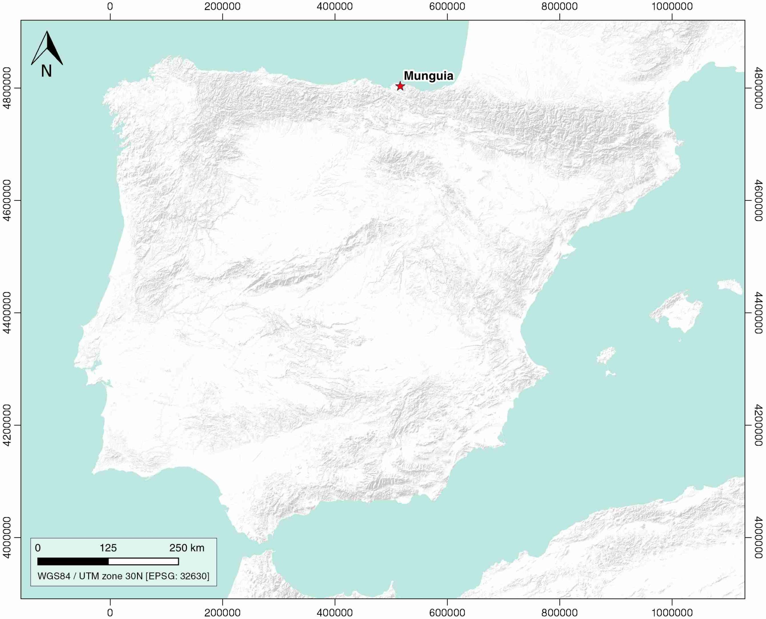
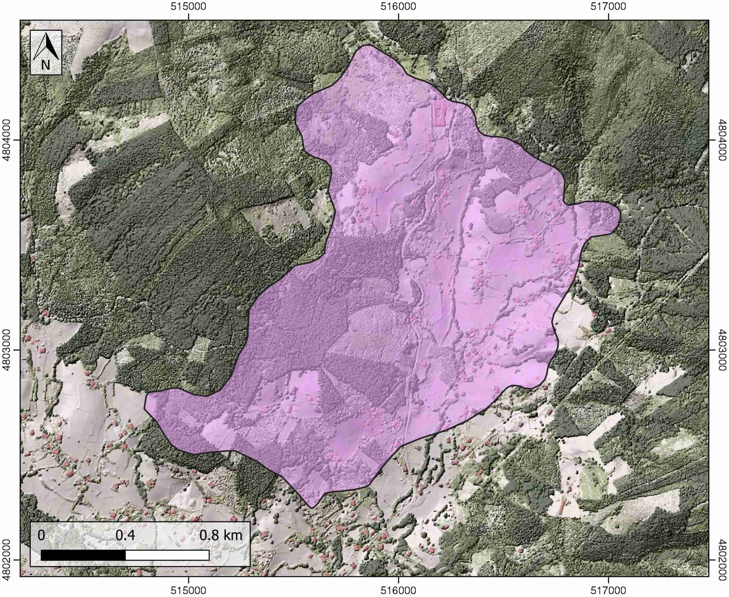
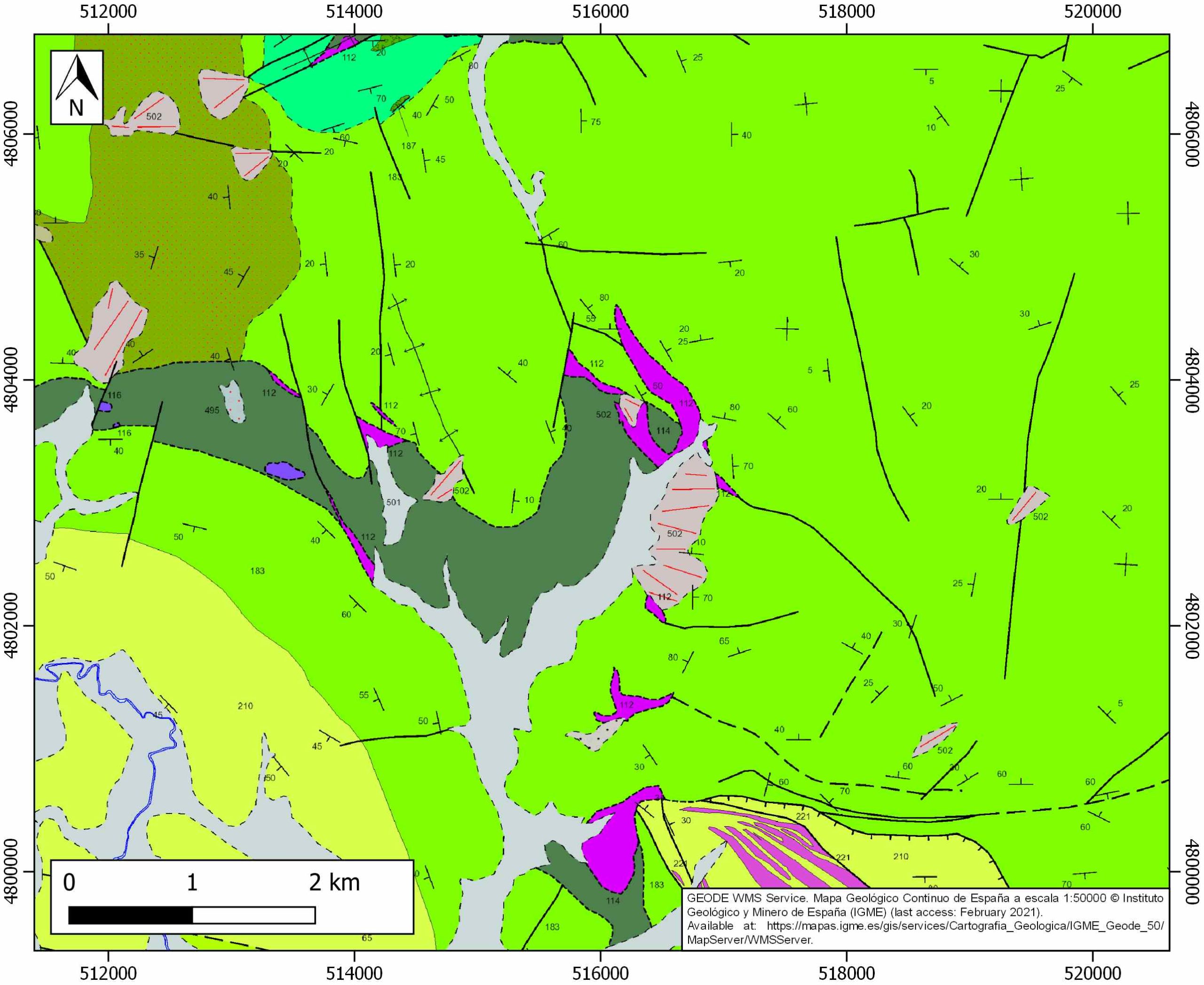
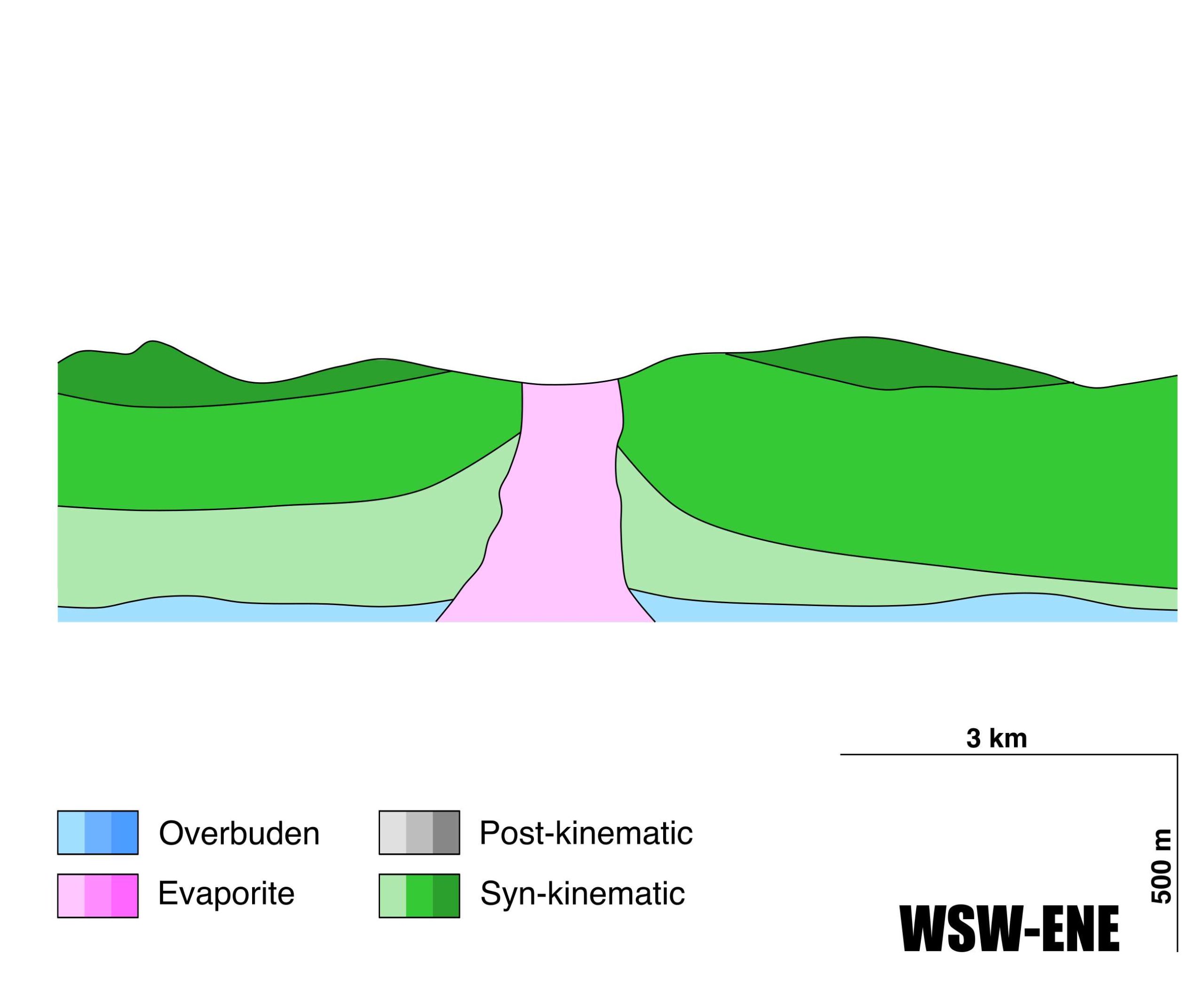
General Information
| Structure type | Evaporite Diapir |
| Deformed/Undeformed | Deformed |
| Geological Setting | Basque Arc, Basque-Cantabrian Basin |
| Outcropping/buried | Outcropping |
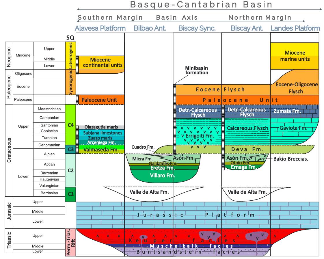
| Evaporite unit/s name | Keuper facies |
| Evaporite unit/s age | Carnian-Rhaetian (Upper Triassic) |
| Evaporite unit/s origin | Marine |
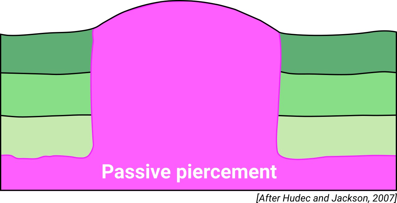
| Classif. (Hudec and Jackson, 2009) | Passive piercement |
| Classif. (Jackson and Talbot, 1986) | Salt wall |
| Age of evaporite flow or deformation (when deformed) | Middle Cretaceous |
| Other comments | - |
Generic Data
| Unique ID | 22 |
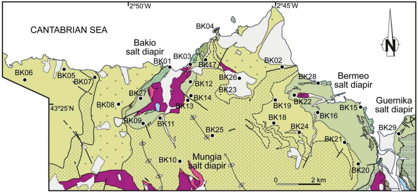
| Name | Munguia |
| Structure type | Evaporite diapir |
| Deformed/Undeformed | Deformed |
| Buried/Outcropping | Outcropping |
| Geological setting | Basque-Cantabrian Basin |
| Geological Regional Setting | Basque Arc |
| Evaporite unit/s name | Keuper facies |
| Evaporite unit/s age | Carnian-Rhaetian (Upper Triassic) |
| Evaporite unit/s era | Mesozoic |
| Evaporite unit/s origin | Marine |
| Evaporite unit/s composition | Claystone-Gypsum-Halite-Anhydrite-Ophites |
| Post-kinematic unit/s (or post-evaporite units when evaporites are undeformed) | Quaternary (alluvial and colluvial detrital deposits) |
| Post-kinematic unit/s age (or post-evaporite units when evaporites are undeformed) | Pleistocene-Holocene |
| Classification (Hudec and Jackson, 2009) | Passive piercement |
| Classification (Jackson and Talbot, 1986) | Salt wall |
| Mining activity? | Y |
| Mining activity start | Roman Empire |
| Mining activity end | |
| Mining galleries? | |
| Mining products | Halite |
| Mining sub-products | |
| Evaporite flow? | Y |
| Age of evaporite flow | Early Aptian – early Cenomanian |
| Flow or deformation triggering mechanisms | High angle regional extensional faults |
| Flow-linked structures? | Y |
| Halokinetic structures | Progressive unconformities / Normal high-angle faults / joints / thickness variations |
| Post-evaporite and pre-kinematic unit/s (overbuden) | Jurassic (dolostones, marls and oolitic limestones) and Neocomian (limestones, marlstones and sandstones) |
| Syn-kinematic unit/s | Aptian-middle Albian (Urgonian Group: marlstones, marly limestones, packstones, carbonate brecchias, rudistid limestones; Punta del Bakio Unit: turbidites, mudstones and carbonate grainstones) / Upper Albian-lower Cenomanian (Deva Formation: pebbly sandstones, siliciclastic sandstones and mudstones; Cabo Villano Formation: mudstones; Plenzia Formation: marlstones, siliciclastic sandstones and carbonate sandstones) |
| Available seismic profiles | BR-28 / BR85-32 / 41 / BR-8 / BR-89-04 / BR-89-04 / BR-1 / BR85-27 / BR85-31 / SBR-1 / SBR-8 / SBR-30 / SBR-33 / SBR-52 / SBR-26 / BR85-34 / SBR-28 / BR-33 / BR-28 / BR-30 / BR-52 |
| Available boreholes | (Private Access): Vitoria-W1 / Cormoran-1 / Alda-1 / Antezana-1 / Sant Antonio-1 / Marinda-1 / Gastaín-1 / Zuñiga-1 / Castillo-2 |
| Additional comments | – |
Mining Data
| UNIQUE_ID | 22 |
| Minning exploitations within <2km? | Y |
| Historical/Active | Historical (not indexed in the Spanish National Minning Cadastre) |
| Exploitation name #1 | n.a. |
| Exploitation ID (Spanish National Mining Cadastre) #1 | n.a. |
| Municipality #1 | n.a. |
| Province #1 | n.a. |
| Company #1 | n.a. |
| Main minning Products #1 | Halite |
| Exploitation name #2 | |
| Exploitation ID (Spanish National Mining Cadastre) #2 | |
| Municipality #2 | |
| Province #2 | |
| Company #2 | |
| Main minning Products #2 | |
| Exploitation name #3 | |
| Exploitation ID (Spanish National Mining Cadastre) #3 | |
| Municipality #3 | |
| Province #3 | |
| Company #3 | |
| Main minning Products #3 |
Quantitative Data
| UNIQUE_ID | 22 |
| Outcropping area (km2) | 2.35367 |
| Horizontal intersection area (km2) (when buried) | Not buried |
| Depth of intersection area (km2) (when buried) | Not buried |
| Max. Width (Km) | 2.1 |
| Max. Length (Km) | 1.7 |
| Max. Evaporites thickness (km) | |
| Max. Deformation age (Ma) | 125 |
| Min. Deformation age (Ma) | 100 |
| Deformation stages | 1 |
Reference Data
| UNIQUE_ID | 22 |
| Section source | Poprawski, Y., Basile, C., 2018. Long-lasting diapir growth history in the Basque-Cantabrian basin (Northern Spain): a review. Conference poster, Advances in Salt Tectonics: Observations, Applications, and Perspective: In Honor of Martin P.A. Jackson. [link] |
| Well / Borehole availability #1 | Poprawski, Y., Basile, C., 2018. Long-lasting diapir growth history in the Basque-Cantabrian basin (Northern Spain): a review. Conference poster, Advances in Salt Tectonics: Observations, Applications, and Perspective: In Honor of Martin P.A. Jackson. [link] |
| Well / Borehole availability #2 | Roca, E., Ferrer, O., Rowan, M. G., Muñoz, J. A., Butillé, M., Giles, K. A., Arbués, P., de Matteis, M., 2020. Salt tectonics and controls on halokinetic-sequence development of an exposed deepwater diapir: The Bakio Diapir, Basque-Cantabrian Basin, Pyrenees. Marine and Petroleum Geology, 104770. [link] |
| Available data (Stratigraphy) #1 | Poprawski, Y., Basile, C., 2018. Long-lasting diapir growth history in the Basque-Cantabrian basin (Northern Spain): a review. Conference poster, Advances in Salt Tectonics: Observations, Applications, and Perspective: In Honor of Martin P.A. Jackson. [link] |
| Available data (Stratigraphy) #2 | Cuevas, J., Tubía, J. M., 1985. Estructuras diapíricas asociadas al sinclinorio de Vizcaya. Munibe, 37, 1-4. [link] |
| Available data (Stratigraphy) #3 | Poprawski, Y., Christophe, B., Etienne, J., Matthieu, G. & Michel, L., 2016. Halokinetic sequences in carbonate systems: an example from the middle Albian Bakio breccias formation (Basque Country, Spain). Sedimentary Geology 334, 34-52. [link] |
| Available data (Stratigraphy) #4 | Bodego, A., Iriarte, E., Agirrezabala, L.M., García-Mondejar, J., López-Horgue, M.A., 2015. Synextensional mid-Cretaceous stratigraphy architecture of the Eastern Basque-Cantabrian basin margin (western Pyrenees). Cretaceous Research, 55, 229-261. [link] |
| Available data (Stratigraphy) #5 | Roca, E., Ferrer, O., Rowan, M. G., Muñoz, J. A., Butillé, M., Giles, K. A., Arbués, P., de Matteis, M., 2020. Salt tectonics and controls on halokinetic-sequence development of an exposed deepwater diapir: The Bakio Diapir, Basque-Cantabrian Basin, Pyrenees. Marine and Petroleum Geology, 104770. [link] |
| Available data (Stratigraphy) #6 | Bodego, A., Iriarte, E., López-Horgue, M. A., Álvarez, I., 2018. Rift-margin extensional forced folds and salt tectonics in the eastern Basque-Cantabrian rift basin (western Pyrenees). Marine and Petroleum Geology, 91, 667-682. https://doi.org/10.1016/j.marpetgeo.2018.02.007 |
| Regional Stratigraphy | Pedrera, A., García‐Senz, J., Ayala, C., Ruiz‐Constán, A., Rodríguez‐Fernández, L. R., Robador, A., González Menéndez, L., 2017. Reconstruction of the exhumed mantle across the North Iberian Margin by crustal‐scale 3‐D gravity inversion and geological cross section. Tectonics, 36, 3155-3177. [link] |
| Seismic data availability #1 | Poprawski, Y., Basile, C., 2018. Long-lasting diapir growth history in the Basque-Cantabrian basin (Northern Spain): a review. Conference poster, Advances in Salt Tectonics: Observations, Applications, and Perspective: In Honor of Martin P.A. Jackson. [link] |
| Seismic data availability #2 | Pedrera, A., García‐Senz, J., Ayala, C., Ruiz‐Constán, A., Rodríguez‐Fernández, L. R., Robador, A., González Menéndez, L., 2017. Reconstruction of the exhumed mantle across the North Iberian Margin by crustal‐scale 3‐D gravity inversion and geological cross section. Tectonics, 36, 3155-3177. [link] |
| Seismic data availability #3 | n.a. |
| Available data (Structure) #1 | Roca, E., Ferrer, O., Rowan, M. G., Muñoz, J. A., Butillé, M., Giles, K. A., Arbués, P., de Matteis, M., 2020. Salt tectonics and controls on halokinetic-sequence development of an exposed deepwater diapir: The Bakio Diapir, Basque-Cantabrian Basin, Pyrenees. Marine and Petroleum Geology, 104770. [link] |
| Available data (Structure) #2 | Soto, R., Beamud, E., Roca, E., Carola, E., Almar, Y., 2017. Distinguishing the effect of diapir growth on magnetic fabrics of syn-diapiric overburden rocks: Basque-Cantabrian basin, Northern Spain. Terra Nova 29, 191-201. http://dx.doi.org/10.1111/ter.12262 |
| Available data (Structure) #3 | Cuevas, J., Tubía, J. M., 1985. Estructuras diapíricas asociadas al sinclinorio de Vizcaya. Munibe, 37, 1-4. [link] |
| Available data (Structure) #4 | Beamud, E., Soto, R., Peigney, C., Roca, E., Pueyo, E. L., 2020. Paleomagnetism on salt-detached syndiapiric overburden rocks from the Northern margin of the Basque-Cantabrian extensional Basin (N Spain). In EGU General Assembly Conference Abstracts (p. 4598). [link] |
| Available data (Structure) #5 | n.a. |
| Available data (Structure) #6 | n.a. |
| Available data (Analogue modelling) #1 | n.a. |
| Available data (Analogue modelling) #2 | n.a. |
| Available data (Analogue modelling) #3 | n.a. |
| Available data (Gravimetry – Tomography) #1 | Nettleton, L.L., 1968. Gravity anomalies over salt diapirs, northern Spain. Geological Society of America Special Papers, 88, 75–82. [link] |
| Available data (Gravimetry – Tomography) #2 | Pedrera, A., García‐Senz, J., Ayala, C., Ruiz‐Constán, A., Rodríguez‐Fernández, L. R., Robador, A., González Menéndez, L., 2017. Reconstruction of the exhumed mantle across the North Iberian Margin by crustal‐scale 3‐D gravity inversion and geological cross section. Tectonics, 36, 3155-3177. [link] |
| Available data (Gravimetry – Tomography) #3 | Ayala, C., Bohoyo, F., Maestro, A., Reguera, M. I., Torne, M., Rubio, F., Fernández, M., García-Lobón, J. L., 2016. Updated Bouguer anomalies of the Iberian Peninsula: a new perspective to interpret the regional geology. Journal of Maps, 12(5), 1089-1092. [link] |
| Available data (Geochemistry) #1 | Ortí, F., García-Veigas, J., Rossell, L., Jurado, M. J., Utrilla, R., 1996. Formaciones salinas de las cuencas triásicas en la Península Ibérica: Caracterización Petrológica y Geoquímica. Cuadernos de Geología Ibérica, 20, 13-35. [link] |
| Available data (Geochemistry) #2 | Iribar, V., Ábalos, B. 2011. The geochemical and isotopic record of evaporite recycling in spas and salterns of the Basque Cantabrian basin, Spain. Applied geochemistry, 26, 1315-1329. [link] |
| Available data (Geochemistry) #3 | n.a. |
| Available data (Geochemistry) #4 | n.a. |
| Available data (Petrophysics) #1 | Soto, R., Beamud, E., Roca, E., Carola, E., Almar, Y., 2017. Distinguishing the effect of diapir growth on magnetic fabrics of syn-diapiric overburden rocks: Basque-Cantabrian basin, Northern Spain. Terra Nova 29, 191-201. [link] |
| Available data (Petrophysics) #2 | Llamas, B., Castañeda, M. C., Laín, C., Pous, J., 2017. Study of the Basque–Cantabrian basin as a suitable region for the implementation of an energy storage system based on compressed air energy storage (CAES). Environmental Earth Sciences, 76(5), 204. [link] |
| IGME Geological Map (MAGNA50) Sheet number | 38-Bermeo. [link] |
| Other Maps #1 (source) | Perona, J., 2016. Mineralizaciones de Pb-Zn asociadas a los diapiros de Murguía y Orduña (Cuenca Vasco-Cantábrica) [PhD thesis]: Barcelona, Universitat de Barcelona, 281 pp. [link] |
| Other Maps #2 (source) | Beamud, E., Soto, R., Roca, E., Carola, E., Almar, Y., Escosa, F., 2016. Datos paleomagnéticos en materiales sin-diapíricos Aptienses-Albienses (cuenca Vasco-Cantábrica, N Iberia). Geo-Temas, 16, 793-796. [link] |
| Other related references #1 | Beamud, E., Soto, R., Roca, E., Carola, E., Almar, Y., Escosa, F., 2016. Datos paleomagnéticos en materiales sin-diapíricos Aptienses-Albienses (cuenca Vasco-Cantábrica, N Iberia). Geo-Temas, 16, 793-796. [link] |
| Other related references #2 | Sanz, T., Lago, M., Gil, A., Galé, C., Ramajo, J., Ubide, T., Pocoví, A., Tierz, P., Larrea, P., 2013. The Upper Triassic alkaline magmatism in the NW Iberian Chain (Spain). Journal of Iberian Geology, 39, 202-222. [link] |
| Other related references #3 | Cámara, P., 2020. Inverted turtle salt anticlines in the eastern basque-cantabrian basin, Spain. Marine and Petroleum Geology, 104358. [link] |
| Other related references #4 | Ruiz, M., Díaz, J., Gallart, J., Pulgar, J.A., González-Cortina, J.M., López, C., 2006. Seismotectonic constraints at the western edge of the Pyrenees: aftershock series monitoring of the 2002 February 21, 4.1 Lg earthquake. Geophysical Journal International, 166, 238–252. [link] |
Well and Seismic Data
| UNIQUE_ID | 22 |
| Seismic survey name #1 | 8B3-BR |
| Across structure? #1 | Y |
| Seismic profile ID (IGME) #1 | 9160 |
| Seismic profile code #1 | 13732 |
| Seismic profile name #1 | BR-28 |
| Seismic survey year #1 | 1978 |
| Data repository #1 | SIGEOF Data Catalogue (Private access section). ©Instituto Geológico y Minero de España (IGME). https://info.igme.es/SIGEOF/ |
| Length (km) #1 | 10.16 |
| Seismic survey name #2 | 8B3-BR85 |
| Across structure? #2 | Y |
| Seismic profile ID (IGME) #2 | 9176 |
| Seismic profile code #2 | 13748 |
| Seismic profile name #2 | BR85-32 |
| Seismic survey year #2 | 1985 |
| Data repository #2 | SIGEOF Data Catalogue (Private access section). ©Instituto Geológico y Minero de España (IGME). https://info.igme.es/SIGEOF/ |
| Length (km) #2 | 7.95 |
| Seismic survey name #3 | 8B-ST-125 |
| Across structure? #3 | Y |
| Seismic profile ID (IGME) #3 | 13141 |
| Seismic profile code #3 | 17859 |
| Seismic profile name #3 | 41 |
| Seismic survey year #3 | 1962 |
| Data repository #3 | SIGEOF Data Catalogue (Private access section). ©Instituto Geológico y Minero de España (IGME). https://info.igme.es/SIGEOF/ |
| Length (km) #3 | 23.62 |
| Seismic survey name #4 | 8B3-BR |
| Across structure? #4 | N (within 3km) |
| Seismic profile ID (IGME) #4 | 9142 |
| Seismic profile code #4 | 13714 |
| Seismic profile name #4 | BR-8 |
| Seismic survey year #4 | 1978 |
| Data repository #4 | SIGEOF Data Catalogue (Section available under request). ©Instituto Geológico y Minero de España (IGME). https://info.igme.es/SIGEOF/ |
| Length (km) #4 | 14.73 |
| Seismic survey name #5 | 0551A89S |
| Across structure? #5 | N (within 3km) |
| Seismic profile ID (IGME) #5 | 293 |
| Seismic profile code #5 | 1399 |
| Seismic profile name #5 | BR-89-04 |
| Seismic survey year #5 | 1989 |
| Data repository #5 | SIGEOF Data Catalogue (Section available under request). ©Instituto Geológico y Minero de España (IGME). https://info.igme.es/SIGEOF/ |
| Length (km) #5 | 4.48 |
| Seismic survey name #6 | 0551A89G |
| Across structure? #6 | N (within 3km) |
| Seismic profile ID (IGME) #6 | 289 |
| Seismic profile code #6 | 1395 |
| Seismic profile name #6 | BR-89-04 |
| Seismic survey year #6 | 1989 |
| Data repository #6 | SIGEOF Data Catalogue (Section available under request). ©Instituto Geológico y Minero de España (IGME). https://info.igme.es/SIGEOF/ |
| Length (km) #6 | 4.50 |
| Seismic survey name #7 | 8B3-BR |
| Across structure? #7 | N (within 3km) |
| Seismic profile ID (IGME) #7 | 9170 |
| Seismic profile code #7 | 13742 |
| Seismic profile name #7 | BR-1 |
| Seismic survey year #7 | 1978 |
| Data repository #7 | SIGEOF Data Catalogue (Private access section). ©Instituto Geológico y Minero de España (IGME). https://info.igme.es/SIGEOF/ |
| Length (km) #7 | 9.28 |
| Seismic survey name #8 | 8B3-BR85 |
| Across structure? #8 | N (within 3km) |
| Seismic profile ID (IGME) #8 | 9181 |
| Seismic profile code #8 | 13753 |
| Seismic profile name #8 | BR85-27 |
| Seismic survey year #8 | 1985 |
| Data repository #8 | SIGEOF Data Catalogue (Private access section). ©Instituto Geológico y Minero de España (IGME). https://info.igme.es/SIGEOF/ |
| Length (km) #8 | 9.68 |
| Seismic survey name #9 | 8B3-BR85 |
| Across structure? #9 | N (within 3km) |
| Seismic profile ID (IGME) #9 | 9177 |
| Seismic profile code #9 | 13749 |
| Seismic profile name #9 | BR85-31 |
| Seismic survey year #9 | 1985 |
| Data repository #9 | SIGEOF Data Catalogue (Private access section). ©Instituto Geológico y Minero de España (IGME). https://info.igme.es/SIGEOF/ |
| Length (km) #9 | 7.98 |
| Seismic survey name #10 | IN2725 |
| Across structure? #10 | N (within 3km) |
| Seismic profile ID (IGME) #10 | 2979 |
| Seismic profile code #10 | 4295 |
| Seismic profile name #10 | SBR-1 |
| Seismic survey year #10 | |
| Data repository #10 | SIGEOF Data Catalogue (Private access section). ©Instituto Geológico y Minero de España (IGME). https://info.igme.es/SIGEOF/ |
| Length (km) #10 | 9.24 |
| Seismic survey name #11 | IN2725 |
| Across structure? #11 | N (within 3km) |
| Seismic profile ID (IGME) #11 | 3002 |
| Seismic profile code #11 | 4318 |
| Seismic profile name #11 | SBR-8 |
| Seismic survey year #11 | |
| Data repository #11 | SIGEOF Data Catalogue (Private access section). ©Instituto Geológico y Minero de España (IGME). https://info.igme.es/SIGEOF/ |
| Length (km) #11 | 12.45 |
| Seismic survey name #12 | IN2725 |
| Across structure? #12 | N (within 3km) |
| Seismic profile ID (IGME) #12 | 2989 |
| Seismic profile code #12 | 4305 |
| Seismic profile name #12 | SBR-30 |
| Seismic survey year #12 | |
| Data repository #12 | SIGEOF Data Catalogue (Private access section). ©Instituto Geológico y Minero de España (IGME). https://info.igme.es/SIGEOF/ |
| Length (km) #12 | 14.22 |
| Seismic survey name #13 | IN2725 |
| Across structure? #13 | N (within 3km) |
| Seismic profile ID (IGME) #13 | 2990 |
| Seismic profile code #13 | 4306 |
| Seismic profile name #13 | SBR-33 |
| Seismic survey year #13 | |
| Data repository #13 | SIGEOF Data Catalogue (Private access section). ©Instituto Geológico y Minero de España (IGME). https://info.igme.es/SIGEOF/ |
| Length (km) #13 | 7.06 |
| Seismic survey name #14 | IN2725 |
| Across structure? #14 | N (within 3km) |
| Seismic profile ID (IGME) #14 | 2998 |
| Seismic profile code #14 | 4314 |
| Seismic profile name #14 | SBR-52 |
| Seismic survey year #14 | |
| Data repository #14 | SIGEOF Data Catalogue (Private access section). ©Instituto Geológico y Minero de España (IGME). https://info.igme.es/SIGEOF/ |
| Length (km) #14 | 5.31 |
| Seismic survey name #15 | IN2725 |
| Across structure? #15 | N (within 3km) |
| Seismic profile ID (IGME) #15 | 2984 |
| Seismic profile code #15 | 4300 |
| Seismic profile name #15 | SBR-26 |
| Seismic survey year #15 | |
| Data repository #15 | SIGEOF Data Catalogue (Private access section). ©Instituto Geológico y Minero de España (IGME). https://info.igme.es/SIGEOF/ |
| Length (km) #15 | 15.48 |
| Seismic survey name #16 | 8B3-BR85 |
| Across structure? #16 | N (within 3km) |
| Seismic profile ID (IGME) #16 | 9174 |
| Seismic profile code #16 | 13746 |
| Seismic profile name #16 | BR85-34 |
| Seismic survey year #16 | 1985 |
| Data repository #16 | SIGEOF Data Catalogue (Private access section). ©Instituto Geológico y Minero de España (IGME). https://info.igme.es/SIGEOF/ |
| Length (km) #16 | 8.76 |
| Seismic survey name #17 | IN2725 |
| Across structure? #17 | N (within 3km) |
| Seismic profile ID (IGME) #17 | 2986 |
| Seismic profile code #17 | 4302 |
| Seismic profile name #17 | SBR-28 |
| Seismic survey year #17 | |
| Data repository #17 | SIGEOF Data Catalogue (Private access section). ©Instituto Geológico y Minero de España (IGME). https://info.igme.es/SIGEOF/ |
| Length (km) #17 | 10.16 |
| Seismic survey name #18 | 8B3-BR |
| Across structure? #18 | N (within 3km) |
| Seismic profile ID (IGME) #18 | 9154 |
| Seismic profile code #18 | 13726 |
| Seismic profile name #18 | BR-33 |
| Seismic survey year #18 | 1978 |
| Data repository #18 | SIGEOF Data Catalogue (Private access section). ©Instituto Geológico y Minero de España (IGME). https://info.igme.es/SIGEOF/ |
| Length (km) #18 | 7.05 |
| Seismic survey name #19 | 8B3-BR |
| Across structure? #19 | N (within 3km) |
| Seismic profile ID (IGME) #19 | 9160 |
| Seismic profile code #19 | 13732 |
| Seismic profile name #19 | BR-28 |
| Seismic survey year #19 | 1978 |
| Data repository #19 | SIGEOF Data Catalogue (Private access section). ©Instituto Geológico y Minero de España (IGME). https://info.igme.es/SIGEOF/ |
| Length (km) #19 | 10.16 |
| Seismic survey name #20 | 8B3-BR |
| Across structure? #20 | N (within 3km) |
| Seismic profile ID (IGME) #20 | 9156 |
| Seismic profile code #20 | 13728 |
| Seismic profile name #20 | BR-30 |
| Seismic survey year #20 | 1978 |
| Data repository #20 | SIGEOF Data Catalogue (Private access section). ©Instituto Geológico y Minero de España (IGME). https://info.igme.es/SIGEOF/ |
| Length (km) #20 | 14.24 |
| Seismic survey name #21 | 8B3-BR |
| Across structure? #21 | N (within 3km) |
| Seismic profile ID (IGME) #21 | 9146 |
| Seismic profile code #21 | 13718 |
| Seismic profile name #21 | BR-52 |
| Seismic survey year #21 | 1978 |
| Data repository #21 | SIGEOF Data Catalogue (Private access section). ©Instituto Geológico y Minero de España (IGME). https://info.igme.es/SIGEOF/ |
| Length (km) #21 | 5.33 |
| Borehole name #1 | |
| Company #1 | |
| Traget #1 | |
| Across structure? #1 | |
| Borehole name #2 | |
| Company #2 | |
| Traget #2 | |
| Across structure? #2 | |
| Borehole name #3 | |
| Company #3 | |
| Traget #3 | |
| Across structure? #3 | |
| Borehole name #4 | |
| Company #4 | |
| Traget #4 | |
| Across structure? #4 | |
| Borehole name #5 | |
| Company #5 | |
| Traget #5 | |
| Across structure? #5 | |
| Borehole name #6 | |
| Company #6 | |
| Traget #6 | |
| Across structure? #6 | |
| Borehole name #7 | |
| Company #7 | |
| Traget #7 | |
| Across structure? #7 | |
| Borehole name #8 | |
| Company #8 | |
| Traget #8 | |
| Across structure? #8 | |
| Borehole name #9 | |
| Company #9 | |
| Traget #9 | |
| Across structure? #9 | |
| Borehole name #10 | |
| Company #10 | |
| Traget #10 | |
| Across structure? #10 | |
| Borehole name #11 | |
| Company #11 | |
| Traget #11 | |
| Across structure? #11 | |
| Borehole name #12 | |
| Company #12 | |
| Traget #12 | |
| Across structure? #12 | |
| Borehole name #13 | |
| Company #13 | |
| Traget #13 | |
| Across structure? #13 | |
| Borehole name #14 | |
| Company #14 | |
| Traget #14 | |
| Across structure? #14 | |
| Borehole name #15 | |
| Company #15 | |
| Traget #15 | |
| Across structure? #15 |
Geographical Data (EPSG:4326 - WGS 84)
| UNIQUE_ID | 22 |
| X Centroid (Structure shape) | -2.802634 |
| Y Centroid (Structure shape) | -2.802634 |
| Xmin (Structure shape) | -2.817443 |
| Xmax (Structure shape) | -2.789397 |
| Ymin (Structure shape) | 43.372927 |
| Ymax (Structure shape) | 43.392782 |
| Xmin seismic line #1 | -2.841340 |
| Xmax seismic line #1 | -2.751418 |
| Ymin seismic line #1 | 43.354852 |
| Ymax seismic line #1 | 43.415409 |
| Xmin seismic line #2 | -2.805459 |
| Xmax seismic line #2 | -2.785771 |
| Ymin seismic line #2 | 43.372977 |
| Ymax seismic line #2 | 43.442987 |
| Xmin seismic line #3 | -2.905954 |
| Xmax seismic line #3 | -2.729875 |
| Ymin seismic line #3 | 43.265797 |
| Ymax seismic line #3 | 43.423788 |
| Xmin seismic line #4 | -2.885462 |
| Xmax seismic line #4 | -2.813760 |
| Ymin seismic line #4 | 43.298681 |
| Ymax seismic line #4 | 43.415104 |
| Xmin seismic line #5 | -2.829603 |
| Xmax seismic line #5 | -2.823993 |
| Ymin seismic line #5 | 43.393635 |
| Ymax seismic line #5 | 43.433664 |
| Xmin seismic line #6 | -2.829631 |
| Xmax seismic line #6 | -2.823993 |
| Ymin seismic line #6 | 43.393551 |
| Ymax seismic line #6 | 43.433774 |
| Xmin seismic line #7 | -2.773519 |
| Xmax seismic line #7 | -2.745337 |
| Ymin seismic line #7 | 43.334991 |
| Ymax seismic line #7 | 43.413342 |
| Xmin seismic line #8 | -2.928360 |
| Xmax seismic line #8 | -2.810869 |
| Ymin seismic line #8 | 43.403475 |
| Ymax seismic line #8 | 43.418476 |
| Xmin seismic line #9 | -2.845313 |
| Xmax seismic line #9 | -2.835284 |
| Ymin seismic line #9 | 43.359621 |
| Ymax seismic line #9 | 43.431021 |
| Xmin seismic line #10 | -2.773045 |
| Xmax seismic line #10 | -2.745129 |
| Ymin seismic line #10 | 43.335051 |
| Ymax seismic line #10 | 43.413274 |
| Xmin seismic line #11 | -2.876492 |
| Xmax seismic line #11 | -2.813381 |
| Ymin seismic line #11 | 43.318021 |
| Ymax seismic line #11 | 43.415051 |
| Xmin seismic line #12 | -2.832660 |
| Xmax seismic line #12 | -2.685821 |
| Ymin seismic line #12 | 43.368134 |
| Ymax seismic line #12 | 43.417970 |
| Xmin seismic line #13 | -2.843743 |
| Xmax seismic line #13 | -2.799574 |
| Ymin seismic line #13 | 43.336688 |
| Ymax seismic line #13 | 43.385998 |
| Xmin seismic line #14 | -2.813770 |
| Xmax seismic line #14 | -2.776936 |
| Ymin seismic line #14 | 43.406663 |
| Ymax seismic line #14 | 43.441164 |
| Xmin seismic line #15 | -2.852631 |
| Xmax seismic line #15 | -2.694544 |
| Ymin seismic line #15 | 43.337549 |
| Ymax seismic line #15 | 43.390717 |
| Xmin seismic line #16 | -2.771014 |
| Xmax seismic line #16 | -2.751144 |
| Ymin seismic line #16 | 43.377775 |
| Ymax seismic line #16 | 43.455127 |
| Xmin seismic line #17 | -2.840992 |
| Xmax seismic line #17 | -2.751046 |
| Ymin seismic line #17 | 43.354968 |
| Ymax seismic line #17 | 43.415387 |
| Xmin seismic line #18 | -2.843950 |
| Xmax seismic line #18 | -2.799942 |
| Ymin seismic line #18 | 43.336745 |
| Ymax seismic line #18 | 43.386020 |
| Xmin seismic line #19 | -2.841340 |
| Xmax seismic line #19 | -2.751418 |
| Ymin seismic line #19 | 43.354852 |
| Ymax seismic line #19 | 43.415409 |
| Xmin seismic line #20 | -2.833220 |
| Xmax seismic line #20 | -2.686153 |
| Ymin seismic line #20 | 43.368194 |
| Ymax seismic line #20 | 43.418059 |
| Xmin seismic line #21 | -2.814189 |
| Xmax seismic line #21 | -2.776990 |
| Ymin seismic line #21 | 43.406820 |
| Ymax seismic line #21 | 43.441349 |
| X borehole #1 | |
| Y borehole #1 | |
| X borehole #2 | |
| Y borehole #2 | |
| X borehole #3 | |
| Y borehole #3 | |
| X borehole #4 | |
| Y borehole #4 | |
| X borehole #5 | |
| Y borehole #5 | |
| X borehole #6 | |
| Y borehole #6 | |
| X borehole #7 | |
| Y borehole #7 | |
| X borehole #8 | |
| Y borehole #8 | |
| X borehole #9 | |
| Y borehole #9 | |
| X borehole #10 | |
| Y borehole #10 | |
| X borehole #11 | |
| Y borehole #11 | |
| X borehole #12 | |
| Y borehole #12 | |
| X borehole #13 | |
| Y borehole #13 | |
| X borehole #14 | |
| Y borehole #14 | |
| X borehole #15 | |
| Y borehole #15 |

