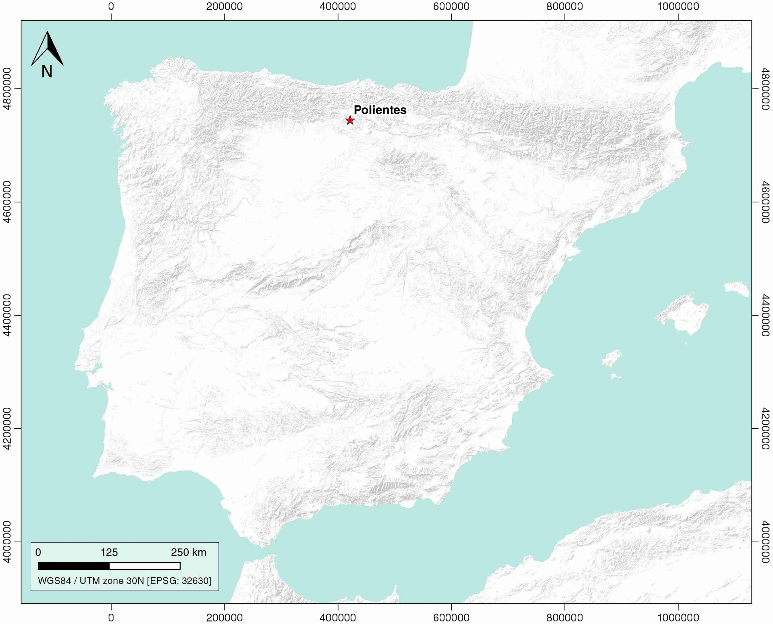
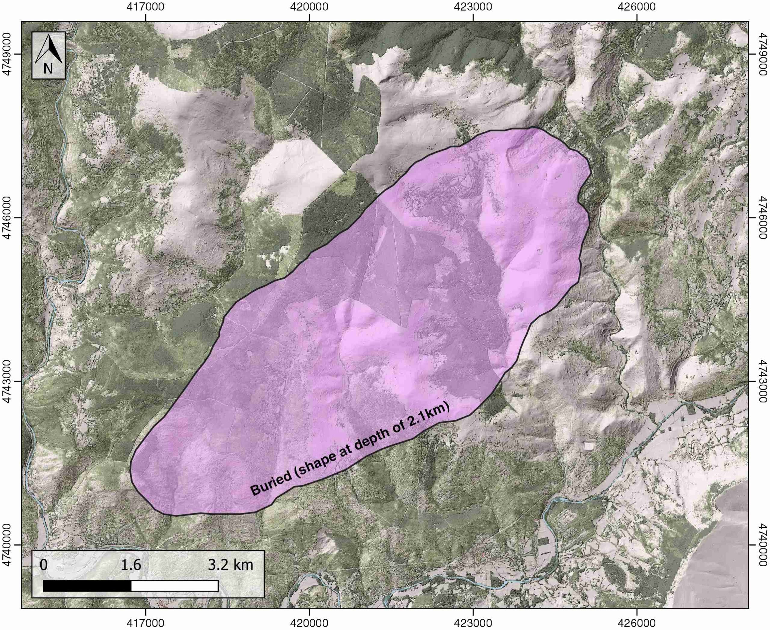
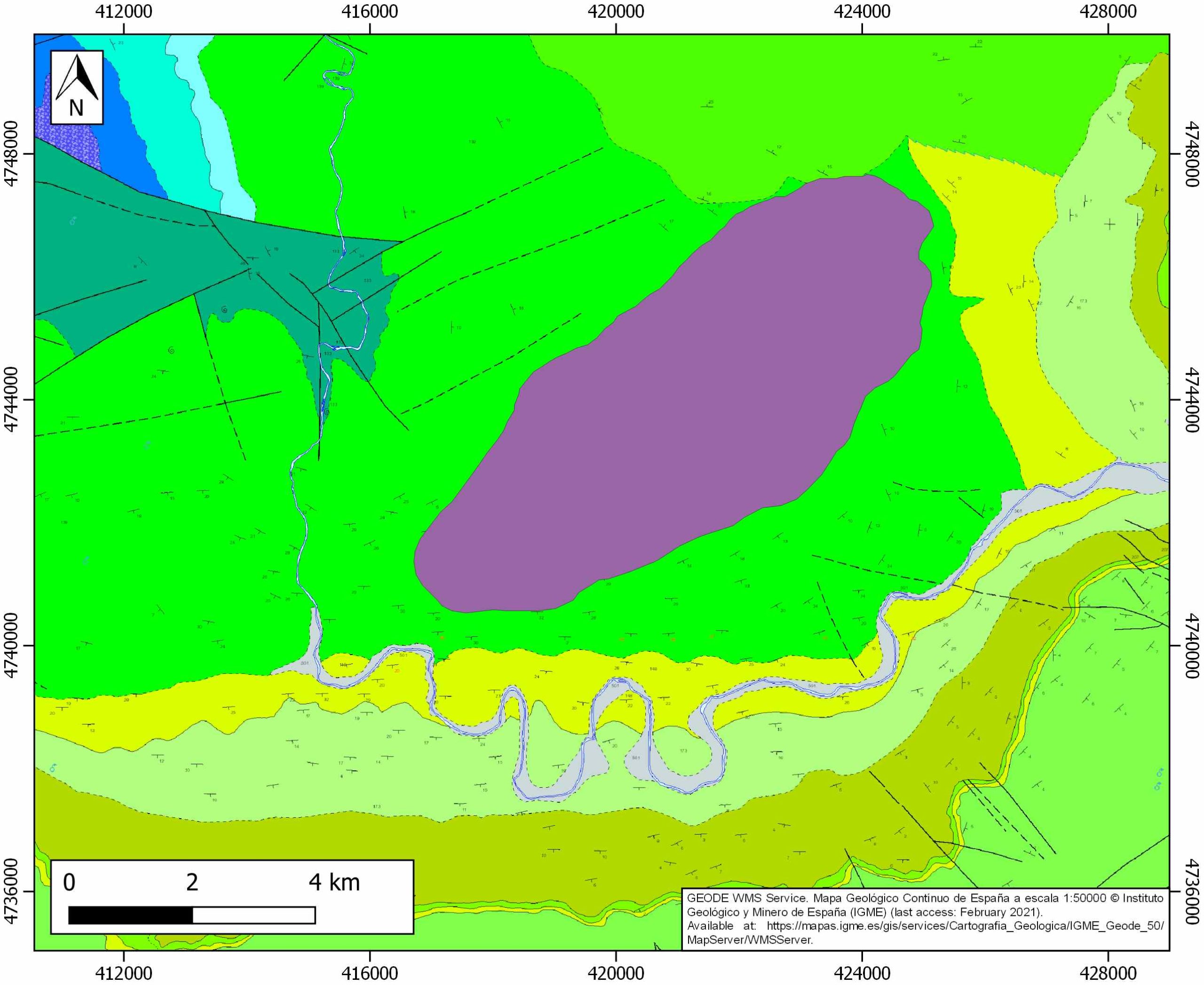
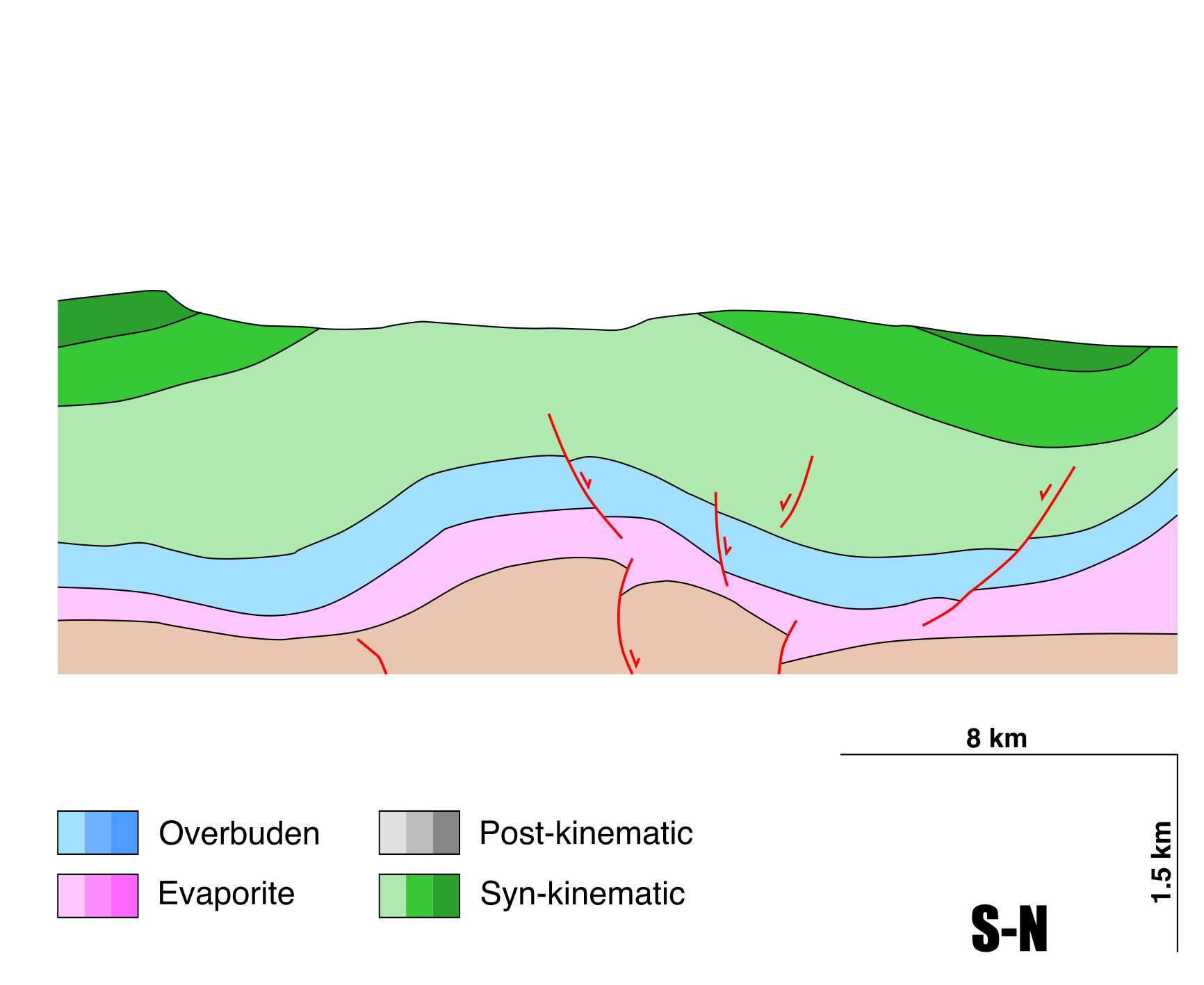
General Information
| Structure type | Evaporite-cored anticline |
| Deformed/Undeformed | Deformed |
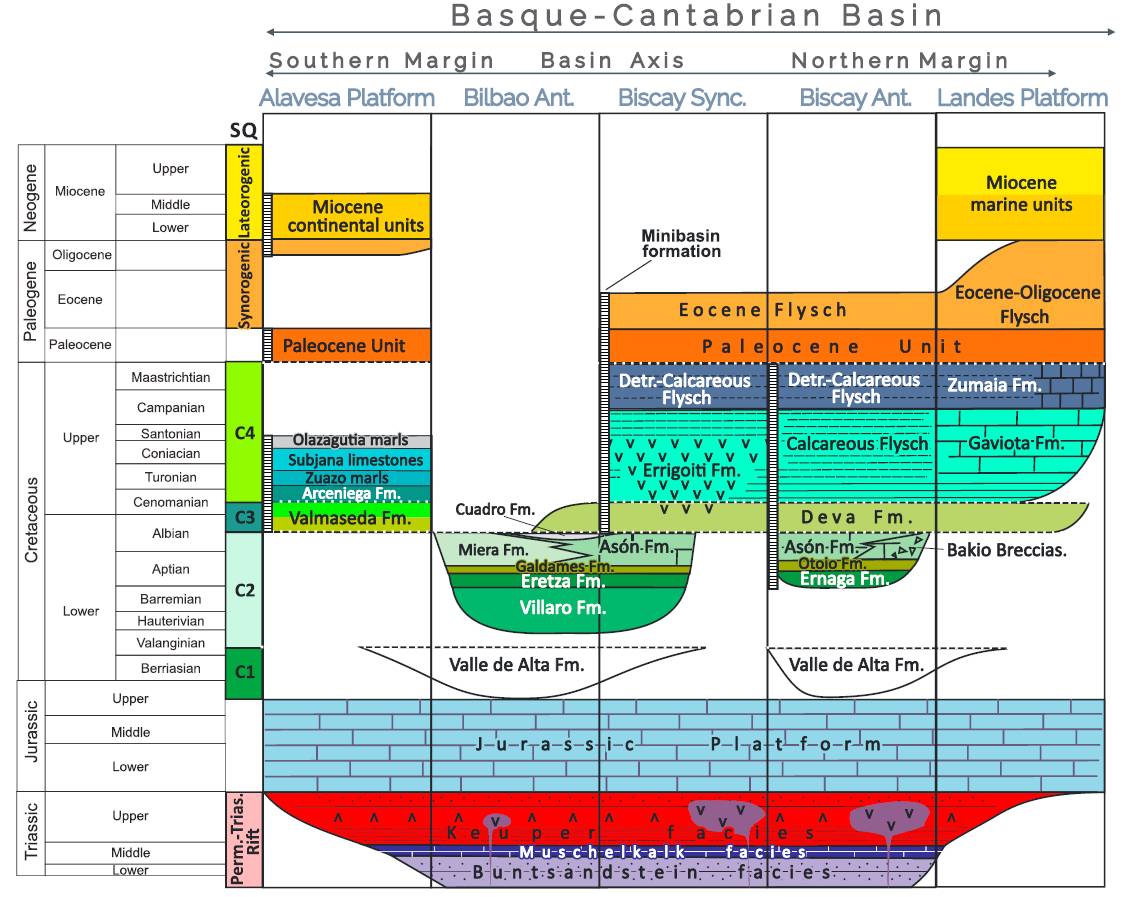
| Geological Setting | Basque-Cantabrian Basin, Burgalesa Platform |
| Outcropping/buried | Buried |
| Evaporite unit/s name | Keuper facies |
| Evaporite unit/s age | Carnian-Rhaetian (Upper Triassic) |
| Evaporite unit/s origin | Marine |
| Classif. (Hudec and Jackson, 2009) | No diapirism |
| Classif. (Jackson and Talbot, 1986) | No diapirism |
| Age of evaporite flow or deformation (when deformed) | Undeformed |
| Other comments | The Ayoluengo oil field is the only onshore oil discovery in Spain. To date, 17 million barrels of oil have been produced from Purbeck sandstones generated from a Lower Liassic source rock. It is located over a Late Jurassic salt anticline with approximately NE-SW axial orientation, close to the Polientes evaporite structure.. |
Generic Data
| Unique ID | 36 |
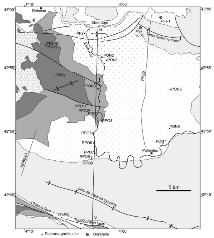
| Name | Polientes |
| Structure type | Evaporite-cored anticline |
| Deformed/Undeformed | Deformed |
| Buried/Outcropping | Buried |
| Geological setting | Basque-Cantabrian Basin |
| Geological Regional Setting | Burgalesa Platform |
| Evaporite unit/s name | Keuper facies |
| Evaporite unit/s age | Carnian-Rhaetian (Upper Triassic) |
| Evaporite unit/s era | Mesozoic |
| Evaporite unit/s origin | Marine |
| Evaporite unit/s composition | Gypsum-Marlstones-Claystone-Shale |
| Post-kinematic unit/s (or post-evaporite units when evaporites are undeformed) | Jurassic (Limestones and dolostones) ; Late Jurassic – Early Cretaceous (Purbeck facies, clays, limestones and sandstones) ; Lower-Middle Cretaceous Weald facies, limestones and sandstones) ; Aptian – Cenomanian (Urgonian-Supraurgonian, limestones and sandstones) ; Late Cretaceous (limestones) |
| Post-kinematic unit/s age (or post-evaporite units when evaporites are undeformed) | Jurassic – Cretaceous |
| Classification (Hudec and Jackson, 2009) | No diapirism |
| Classification (Jackson and Talbot, 1986) | No diapirism |
| Mining activity? | Y |
| Mining activity start | |
| Mining activity end | |
| Mining galleries? | |
| Mining products | |
| Mining sub-products | |
| Evaporite flow? | N |
| Age of evaporite flow | – |
| Flow or deformation triggering mechanisms | – |
| Flow-linked structures? | – |
| Halokinetic structures | – |
| Post-evaporite and pre-kinematic unit/s (overbuden) | – |
| Syn-kinematic unit/s | – |
| Available seismic profiles | BG-83 / 14 / PR85-04 / B-20 / PR85-06 / PR85-03 / PR-22 / PR85-02 / 44212 / 44213 / PR21 / B-28 / B-25 / PR69 / PR-23 / PR27 / PR-25 / PR70 / PR-22 / PR27 / PR-23 |
| Available boreholes | COTO-1 / VILLAMOÑICO-10 / POLIENTES-2 / POLIENTES-3 / POLIENTES-1 / POLIENTES-6 / POLIENTES-5 / POLIENTES-9 / POLIENTES-4 |
| Additional comments | The Ayoluengo oil field is the only onshore oil discovery in Spain. To date, 17 million barrels of oil have been produced from Purbeck sandstones generated from a Lower Liassic source rock. It is located over a Late Jurassic salt anticline with approximately NE-SW axial orientation. |
Mining Data
| UNIQUE_ID | 36 |
| Minning exploitations within <2km? | Y |
| Historical/Active | Historical (not indexed in the Spanish National Minning Cadastre) |
| Exploitation name #1 | n.a. |
| Exploitation ID (Spanish National Mining Cadastre) #1 | n.a. |
| Municipality #1 | n.a. |
| Province #1 | n.a. |
| Company #1 | n.a. |
| Main minning Products #1 | n.a. |
| Exploitation name #2 | |
| Exploitation ID (Spanish National Mining Cadastre) #2 | |
| Municipality #2 | |
| Province #2 | |
| Company #2 | |
| Main minning Products #2 | |
| Exploitation name #3 | |
| Exploitation ID (Spanish National Mining Cadastre) #3 | |
| Municipality #3 | |
| Province #3 | |
| Company #3 | |
| Main minning Products #3 |
Quantitative Data
| UNIQUE_ID | 36 |
| Outcropping area (km2) | Buried |
| Horizontal intersection area (km2) (when buried) | 31.61593 |
| Depth of intersection area (km2) (when buried) | 2.1 |
| Max. Width (Km) | 10.2 |
| Max. Length (Km) | 4.3 |
| Max. Evaporites thickness (km) | 0.4 |
| Max. Deformation age (Ma) | – |
| Min. Deformation age (Ma) | – |
| Deformation stages | 0 |
Reference Data
| UNIQUE_ID | 36 |
| Section source | Cámara, P., 2017. Salt and Strike-Slip Tectonics as Main Drivers in the Structural Evolution of the Basque-Cantabrian Basin, Spain. In Permo-Triassic Salt Provinces of Europe, North Africa and the Atlantic Margins (pp. 371-393). Elsevier. [link] |
| Well / Borehole availability #1 | Carola, E., Muñoz, J. A., Roca, E., 2015. The transition from thick-skinned to thin-skinned tectonics in the Basque-Cantabrian Pyrenees: The Burgalesa Platform and surroundings. International Journal of Earth Sciences, 104(8), 2215-2239. [link] |
| Well / Borehole availability #2 | Cámara, P., 2017. Salt and Strike-Slip Tectonics as Main Drivers in the Structural Evolution of the Basque-Cantabrian Basin, Spain. In Permo-Triassic Salt Provinces of Europe, North Africa and the Atlantic Margins (pp. 371-393). Elsevier. [link] |
| Available data (Stratigraphy) #1 | Cámara, P., 2017. Salt and Strike-Slip Tectonics as Main Drivers in the Structural Evolution of the Basque-Cantabrian Basin, Spain. In Permo-Triassic Salt Provinces of Europe, North Africa and the Atlantic Margins (pp. 371-393). Elsevier. [link] |
| Available data (Stratigraphy) #2 | Beroiz, C., Permanyer, A., 2011. Hydrocarbon habitat of the Sedano Trough, Basque‐Cantabrian Basin, Spain. Journal of Petroleum Geology, 34(4), 387-409. [link] |
| Available data (Stratigraphy) #3 | Martín-Chivelet, J., López-Gómez, J., Aguado, R., Arias, C., Arribas, J., Arribas, M. E., … , Casas-Sainz, A., 2019. The Late Jurassic–Early Cretaceous Rifting. In (Quesada C., Oliveira J., eds.): The Geology of Iberia: A Geodynamic Approach. Regional Geology Reviews. Springer, Cham. [link] |
| Available data (Stratigraphy) #4 | Espina, R. G., 1997. La estructura y evolución tectonoestatigráfica del borde occidental de la Cuenca Vasco-Cantábrica (Cordillera Cantábrica, NO de España) [Ph.D. thesis]: Univeridad de Oviedo: 230 p. [link] |
| Available data (Stratigraphy) #5 | Carola, E., Muñoz, J. A., Roca, E., 2015. The transition from thick-skinned to thin-skinned tectonics in the Basque-Cantabrian Pyrenees: The Burgalesa Platform and surroundings. International Journal of Earth Sciences, 104(8), 2215-2239. [link] |
| Available data (Stratigraphy) #6 | Peropadre, C., Mediato, J. F., Hernaiz, P. P., Robador, A., Solé, F. X., Sarrionandía, F., 2012. La discordancia de La Mesa (base de las Facies Utrillas) en el sinclinal de Polientes (Cretácico, Cuenca Vasco-Cantábrica): implicaciones tectónicas. Geotemas, 13, 85. [link] |
| Regional Stratigraphy | Pedrera, A., García‐Senz, J., Ayala, C., Ruiz‐Constán, A., Rodríguez‐Fernández, L. R., Robador, A., González Menéndez, L., 2017. Reconstruction of the exhumed mantle across the North Iberian Margin by crustal‐scale 3‐D gravity inversion and geological cross section. Tectonics, 36, 3155-3177. [link] |
| Seismic data availability #1 | Carola, E., Muñoz, J. A., Roca, E., 2015. The transition from thick-skinned to thin-skinned tectonics in the Basque-Cantabrian Pyrenees: The Burgalesa Platform and surroundings. International Journal of Earth Sciences, 104(8), 2215-2239. [link] |
| Seismic data availability #2 | Cámara, P., 2017. Salt and Strike-Slip Tectonics as Main Drivers in the Structural Evolution of the Basque-Cantabrian Basin, Spain. In Permo-Triassic Salt Provinces of Europe, North Africa and the Atlantic Margins (pp. 371-393). Elsevier. [link] |
| Seismic data availability #3 | Soto, R., Casas-Sainz, A. M., Villalaín, J. J., 2011. Widespread Cretaceous inversion event in northern Spain: evidence from subsurface and palaeomagnetic data. Journal of the Geological Society, 168(4), 899-912. [link] |
| Available data (Structure) #1 | Cámara, P., 2017. Salt and Strike-Slip Tectonics as Main Drivers in the Structural Evolution of the Basque-Cantabrian Basin, Spain. In Permo-Triassic Salt Provinces of Europe, North Africa and the Atlantic Margins (pp. 371-393). Elsevier. [link] |
| Available data (Structure) #2 | Carola, E., Muñoz, J. A., Roca, E., 2015. The transition from thick-skinned to thin-skinned tectonics in the Basque-Cantabrian Pyrenees: The Burgalesa Platform and surroundings. International Journal of Earth Sciences, 104(8), 2215-2239. [link] |
| Available data (Structure) #3 | Soto, R., Casas-Sainz, A. M., Villalaín, J. J., 2011. Widespread Cretaceous inversion event in northern Spain: evidence from subsurface and palaeomagnetic data. Journal of the Geological Society, 168(4), 899-912. [link] |
| Available data (Structure) #4 | Pedrera, A., García‐Senz, J., Ayala, C., Ruiz‐Constán, A., Rodríguez‐Fernández, L. R., Robador, A., González Menéndez, L., 2017. Reconstruction of the exhumed mantle across the North Iberian Margin by crustal‐scale 3‐D gravity inversion and geological cross section. Tectonics, 36, 3155-3177. [link] |
| Available data (Structure) #5 | Espina, R. G., 1997. La estructura y evolución tectonoestatigráfica del borde occidental de la Cuenca Vasco-Cantábrica (Cordillera Cantábrica, NO de España) [Ph.D. thesis]: Univeridad de Oviedo: 230 p. [link] |
| Available data (Structure) #6 | Soto, R., Casas-Sainz, A. M., Villalaín J. J., Gil-Imaz, A., Fernandez-Gonzalez, G., Del Rio, P., Calvo, M., Mochales, T., 2008. Characterizing the Mesozoic extension direction in the northern Iberian plate margin by anisotropy of magnetic susceptibility (AMS). Journal of the Geological Society, 165(6), 1007-1018. [link] |
| Available data (Analogue modelling) #1 | Vendeville, B. C., Jackson, M. P. A., 1992. The fall of diapirs during thin-skinned extension. Marine and Petroleum Geology, 9(4), 354-371. [link] |
| Available data (Analogue modelling) #2 | n.a. |
| Available data (Analogue modelling) #3 | n.a. |
| Available data (Gravimetry – Tomography) #1 | Ayala, C., Bohoyo, F., Maestro, A., Reguera, M. I., Torne, M., Rubio, F., Fernández, M., García-Lobón, J. L., 2016. Updated Bouguer anomalies of the Iberian Peninsula: a new perspective to interpret the regional geology. Journal of Maps, 12(5), 1089-1092. [link] |
| Available data (Gravimetry – Tomography) #2 | Nettleton, L.L., 1968. Gravity anomalies over salt diapirs, northern Spain. Geological Society of America Special Papers, 88, 75–82. [link] |
| Available data (Gravimetry – Tomography) #3 | Pedrera, A., García‐Senz, J., Ayala, C., Ruiz‐Constán, A., Rodríguez‐Fernández, L. R., Robador, A., González Menéndez, L., 2017. Reconstruction of the exhumed mantle across the North Iberian Margin by crustal‐scale 3‐D gravity inversion and geological cross section. Tectonics, 36, 3155-3177. [link] |
| Available data (Geochemistry) #1 | Ortí, F., García-Veigas, J., Rossell, L., Jurado, M. J., Utrilla, R., 1996. Formaciones salinas de las cuencas triásicas en la Península Ibérica: Caracterización Petrológica y Geoquímica. Cuadernos de Geología Ibérica, 20, 13-35. [link] |
| Available data (Geochemistry) #2 | Béziat, D., Joron, J.L., Monchoux, P., Treuil, M., Walgenwitz, F., 1991. Geodynamic implications of geochemical data for the Pyrenean ophites (Spain-France). Chemical Geology, 89, 243-262. [link] |
| Available data (Geochemistry) #3 | Iribar, V., Ábalos, B. 2011. The geochemical and isotopic record of evaporite recycling in spas and salterns of the Basque Cantabrian basin, Spain. Applied geochemistry, 26, 1315-1329. [link] |
| Available data (Geochemistry) #4 | n.a. |
| Available data (Petrophysics) #1 | Soto, R., Casas-Sainz, A. M., Villalaín J. J., Gil-Imaz, A., Fernandez-Gonzalez, G., Del Rio, P., Calvo, M., Mochales, T., 2008. Characterizing the Mesozoic extension direction in the northern Iberian plate margin by anisotropy of magnetic susceptibility (AMS). Journal of the Geological Society, 165(6), 1007-1018. [link] |
| Available data (Petrophysics) #2 | Soto, R., Beamud, E., Roca, E., Carola, E., Almar, Y., 2017. Distinguishing the effect of diapir growth on magnetic fabrics of syn-diapiric overburden rocks: Basque-Cantabrian basin, Northern Spain. Terra Nova 29, 191-201. [link] |
| IGME Geological Map (MAGNA50) Sheet number | 134-Polientes. [link] |
| Other Maps #1 (source) | Perona, J., 2016. Mineralizaciones de Pb-Zn asociadas a los diapiros de Murguía y Orduña (Cuenca Vasco-Cantábrica) [PhD thesis]: Barcelona, Universitat de Barcelona, 281 pp. [link] |
| Other Maps #2 (source) | Soto, R., Casas-Sainz, A. M., Villalaín, J. J., 2011. Widespread Cretaceous inversion event in northern Spain: evidence from subsurface and palaeomagnetic data. Journal of the Geological Society, 168(4), 899-912. [link] |
| Other related references #1 | Ábalos, B., 2016. Geologic map of the Basque-Cantabrian Basin and a new tectonic interpretation of the Basque Arc. International Journal of Earth Sciences, 105, 2327-2354. [link] |
| Other related references #2 | Martín-Chivelet, J., López-Gómez, J., Aguado, R., Arias, C., Arribas, J., Arribas, M. E., … , Casas-Sainz, A., 2019. The Late Jurassic–Early Cretaceous Rifting. In (Quesada C., Oliveira J., eds.): The Geology of Iberia: A Geodynamic Approach. Regional Geology Reviews. Springer, Cham. [link] |
| Other related references #3 | Santos-González, J., Marcos-Reguero, A., 2019. Applying the geological heritage in land management: cartography and management proposals of geosites in Burgos Province (Spain). Geoheritage, 11(2), 485-500. [link] |
| Other related references #4 | n.a. |
Well and Seismic Data
| UNIQUE_ID | 36 |
| Seismic survey name #1 | 7C3-BG |
| Across structure? #1 | Y |
| Seismic profile ID (IGME) #1 | 9508 |
| Seismic profile code #1 | 14081 |
| Seismic profile name #1 | BG-83 |
| Seismic survey year #1 | 1975 |
| Data repository #1 | SIGEOF Data Catalogue (Private access section). ©Instituto Geológico y Minero de España (IGME). https://info.igme.es/SIGEOF/ |
| Length (km) #1 | 13.58 |
| Seismic survey name #2 | 7C-ST-98-98BIS |
| Across structure? #2 | Y |
| Seismic profile ID (IGME) #2 | 12927 |
| Seismic profile code #2 | 17645 |
| Seismic profile name #2 | 14 |
| Seismic survey year #2 | 1961 |
| Data repository #2 | SIGEOF Data Catalogue (Private access section). ©Instituto Geológico y Minero de España (IGME). https://info.igme.es/SIGEOF/ |
| Length (km) #2 | 11.71 |
| Seismic survey name #3 | 7C4-PR85 |
| Across structure? #3 | Y |
| Seismic profile ID (IGME) #3 | 9680 |
| Seismic profile code #3 | 14253 |
| Seismic profile name #3 | PR85-04 |
| Seismic survey year #3 | 1985 |
| Data repository #3 | SIGEOF Data Catalogue (Private access section). ©Instituto Geológico y Minero de España (IGME). https://info.igme.es/SIGEOF/ |
| Length (km) #3 | 7.91 |
| Seismic survey name #4 | 7C-ST-70 |
| Across structure? #4 | Y |
| Seismic profile ID (IGME) #4 | 12571 |
| Seismic profile code #4 | 17289 |
| Seismic profile name #4 | B-20 |
| Seismic survey year #4 | 1971 |
| Data repository #4 | SIGEOF Data Catalogue (Private access section). ©Instituto Geológico y Minero de España (IGME). https://info.igme.es/SIGEOF/ |
| Length (km) #4 | 17.50 |
| Seismic survey name #5 | 7C4-PR85 |
| Across structure? #5 | Y |
| Seismic profile ID (IGME) #5 | 9678 |
| Seismic profile code #5 | 14251 |
| Seismic profile name #5 | PR85-06 |
| Seismic survey year #5 | 1985 |
| Data repository #5 | SIGEOF Data Catalogue (Private access section). ©Instituto Geológico y Minero de España (IGME). https://info.igme.es/SIGEOF/ |
| Length (km) #5 | 10.62 |
| Seismic survey name #6 | 7C4-PR85 |
| Across structure? #6 | Y |
| Seismic profile ID (IGME) #6 | 9681 |
| Seismic profile code #6 | 14254 |
| Seismic profile name #6 | PR85-03 |
| Seismic survey year #6 | 1985 |
| Data repository #6 | SIGEOF Data Catalogue (Private access section). ©Instituto Geológico y Minero de España (IGME). https://info.igme.es/SIGEOF/ |
| Length (km) #6 | 8.03 |
| Seismic survey name #7 | 7C4-PR |
| Across structure? #7 | Y |
| Seismic profile ID (IGME) #7 | 9655 |
| Seismic profile code #7 | 14228 |
| Seismic profile name #7 | PR-22 |
| Seismic survey year #7 | 1976 |
| Data repository #7 | SIGEOF Data Catalogue (Section available under request). ©Instituto Geológico y Minero de España (IGME). https://info.igme.es/SIGEOF/ |
| Length (km) #7 | 18.95 |
| Seismic survey name #8 | 7C4-PR85 |
| Across structure? #8 | Y |
| Seismic profile ID (IGME) #8 | 9682 |
| Seismic profile code #8 | 14255 |
| Seismic profile name #8 | PR85-02 |
| Seismic survey year #8 | 1985 |
| Data repository #8 | SIGEOF Data Catalogue (Private access section). ©Instituto Geológico y Minero de España (IGME). https://info.igme.es/SIGEOF/ |
| Length (km) #8 | 7.77 |
| Seismic survey name #9 | 7C-ST-98-98BIS |
| Across structure? #9 | Y |
| Seismic profile ID (IGME) #9 | 12921 |
| Seismic profile code #9 | 17639 |
| Seismic profile name #9 | 44212 |
| Seismic survey year #9 | 1961 |
| Data repository #9 | SIGEOF Data Catalogue (Private access section). ©Instituto Geológico y Minero de España (IGME). https://info.igme.es/SIGEOF/ |
| Length (km) #9 | 15.77 |
| Seismic survey name #10 | 7C-ST-98-98BIS |
| Across structure? #10 | Y |
| Seismic profile ID (IGME) #10 | 12918 |
| Seismic profile code #10 | 17636 |
| Seismic profile name #10 | 44213 |
| Seismic survey year #10 | 1961 |
| Data repository #10 | SIGEOF Data Catalogue (Private access section). ©Instituto Geológico y Minero de España (IGME). https://info.igme.es/SIGEOF/ |
| Length (km) #10 | 8.45 |
| Seismic survey name #11 | 7C4-PR21 |
| Across structure? #11 | Y |
| Seismic profile ID (IGME) #11 | 9670 |
| Seismic profile code #11 | 14243 |
| Seismic profile name #11 | PR21 |
| Seismic survey year #11 | 1976 |
| Data repository #11 | SIGEOF Data Catalogue (Section available under request). ©Instituto Geológico y Minero de España (IGME). https://info.igme.es/SIGEOF/ |
| Length (km) #11 | 31.29 |
| Seismic survey name #12 | 0249A74G |
| Across structure? #12 | Y |
| Seismic profile ID (IGME) #12 | 60 |
| Seismic profile code #12 | 558 |
| Seismic profile name #12 | B-28 |
| Seismic survey year #12 | 1974 |
| Data repository #12 | SIGEOF Data Catalogue (Private access section). ©Instituto Geológico y Minero de España (IGME). https://info.igme.es/SIGEOF/ |
| Length (km) #12 | 9.46 |
| Seismic survey name #13 | 0249A74G |
| Across structure? #13 | Y |
| Seismic profile ID (IGME) #13 | 55 |
| Seismic profile code #13 | 553 |
| Seismic profile name #13 | B-25 |
| Seismic survey year #13 | 1974 |
| Data repository #13 | SIGEOF Data Catalogue (Private access section). ©Instituto Geológico y Minero de España (IGME). https://info.igme.es/SIGEOF/ |
| Length (km) #13 | 16.79 |
| Seismic survey name #14 | 7C4-PR69 |
| Across structure? #14 | Y |
| Seismic profile ID (IGME) #14 | 9672 |
| Seismic profile code #14 | 14245 |
| Seismic profile name #14 | PR69 |
| Seismic survey year #14 | 1976 |
| Data repository #14 | SIGEOF Data Catalogue (Section available under request). ©Instituto Geológico y Minero de España (IGME). https://info.igme.es/SIGEOF/ |
| Length (km) #14 | 6.77 |
| Seismic survey name #15 | 7C4-PR |
| Across structure? #15 | Y |
| Seismic profile ID (IGME) #15 | 9654 |
| Seismic profile code #15 | 14227 |
| Seismic profile name #15 | PR-23 |
| Seismic survey year #15 | 1976 |
| Data repository #15 | SIGEOF Data Catalogue (Section available under request). ©Instituto Geológico y Minero de España (IGME). https://info.igme.es/SIGEOF/ |
| Length (km) #15 | 19.11 |
| Seismic survey name #16 | 7C4-PR27 |
| Across structure? #16 | Y |
| Seismic profile ID (IGME) #16 | 9671 |
| Seismic profile code #16 | 14244 |
| Seismic profile name #16 | PR27 |
| Seismic survey year #16 | 1976 |
| Data repository #16 | SIGEOF Data Catalogue (Section available under request). ©Instituto Geológico y Minero de España (IGME). https://info.igme.es/SIGEOF/ |
| Length (km) #16 | 20.54 |
| Seismic survey name #17 | 7C4-PR |
| Across structure? #17 | Y |
| Seismic profile ID (IGME) #17 | 9652 |
| Seismic profile code #17 | 14225 |
| Seismic profile name #17 | PR-25 |
| Seismic survey year #17 | 1976 |
| Data repository #17 | SIGEOF Data Catalogue (Section available under request). ©Instituto Geológico y Minero de España (IGME). https://info.igme.es/SIGEOF/ |
| Length (km) #17 | 19.55 |
| Seismic survey name #18 | 7C4-PR70 |
| Across structure? #18 | Y |
| Seismic profile ID (IGME) #18 | 9673 |
| Seismic profile code #18 | 14246 |
| Seismic profile name #18 | PR70 |
| Seismic survey year #18 | 1976 |
| Data repository #18 | SIGEOF Data Catalogue (Section available under request). ©Instituto Geológico y Minero de España (IGME). https://info.igme.es/SIGEOF/ |
| Length (km) #18 | 11.98 |
| Seismic survey name #19 | 7C4-PR |
| Across structure? #19 | N (within 3km) |
| Seismic profile ID (IGME) #19 | 9655 |
| Seismic profile code #19 | 14228 |
| Seismic profile name #19 | PR-22 |
| Seismic survey year #19 | 1976 |
| Data repository #19 | SIGEOF Data Catalogue (Section available under request). ©Instituto Geológico y Minero de España (IGME). https://info.igme.es/SIGEOF/ |
| Length (km) #19 | 18.95 |
| Seismic survey name #20 | 7C4-PR27 |
| Across structure? #20 | N (within 3km) |
| Seismic profile ID (IGME) #20 | 9671 |
| Seismic profile code #20 | 14244 |
| Seismic profile name #20 | PR27 |
| Seismic survey year #20 | 1976 |
| Data repository #20 | SIGEOF Data Catalogue (Section available under request). ©Instituto Geológico y Minero de España (IGME). https://info.igme.es/SIGEOF/ |
| Length (km) #20 | 20.54 |
| Seismic survey name #21 | 7C4-PR |
| Across structure? #21 | N (within 3km) |
| Seismic profile ID (IGME) #21 | 9654 |
| Seismic profile code #21 | 14227 |
| Seismic profile name #21 | PR-23 |
| Seismic survey year #21 | 1976 |
| Data repository #21 | SIGEOF Data Catalogue (Section available under request). ©Instituto Geológico y Minero de España (IGME). https://info.igme.es/SIGEOF/ |
| Length (km) #21 | 19.11 |
| Borehole name #1 | COTO-1 |
| Company #1 | YCI ESPAÑA |
| Traget #1 | HYDROCARBONS |
| Across structure? #1 | N (within 5 km) |
| Borehole name #2 | VILLAMOÑICO-10 |
| Company #2 | IGME |
| Traget #2 | INDUSTRIAL ROCKS |
| Across structure? #2 | N (within 5 km) |
| Borehole name #3 | POLIENTES-2 |
| Company #3 | ADARO |
| Traget #3 | INDUSTRIAL ROCKS |
| Across structure? #3 | N (within 5 km) |
| Borehole name #4 | POLIENTES-3 |
| Company #4 | ADARO |
| Traget #4 | INDUSTRIAL ROCKS |
| Across structure? #4 | N (within 5 km) |
| Borehole name #5 | POLIENTES-1 |
| Company #5 | ADARO |
| Traget #5 | INDUSTRIAL ROCKS |
| Across structure? #5 | N (within 5 km) |
| Borehole name #6 | POLIENTES-6 |
| Company #6 | ADARO |
| Traget #6 | INDUSTRIAL ROCKS |
| Across structure? #6 | N (within 5 km) |
| Borehole name #7 | POLIENTES-5 |
| Company #7 | ADARO |
| Traget #7 | INDUSTRIAL ROCKS |
| Across structure? #7 | N (within 5 km) |
| Borehole name #8 | POLIENTES-9 |
| Company #8 | IGME |
| Traget #8 | INDUSTRIAL ROCKS |
| Across structure? #8 | N (within 5 km) |
| Borehole name #9 | POLIENTES-4 |
| Company #9 | ADARO |
| Traget #9 | INDUSTRIAL ROCKS |
| Across structure? #9 | N (within 5 km) |
| Borehole name #10 | |
| Company #10 | |
| Traget #10 | |
| Across structure? #10 | |
| Borehole name #11 | |
| Company #11 | |
| Traget #11 | |
| Across structure? #11 | |
| Borehole name #12 | |
| Company #12 | |
| Traget #12 | |
| Across structure? #12 | |
| Borehole name #13 | |
| Company #13 | |
| Traget #13 | |
| Across structure? #13 | |
| Borehole name #14 | |
| Company #14 | |
| Traget #14 | |
| Across structure? #14 | |
| Borehole name #15 | |
| Company #15 | |
| Traget #15 | |
| Across structure? #15 |
Geographical Data (EPSG:4326 - WGS 84)
| UNIQUE_ID | 36 |
| X Centroid (Structure shape) | -3.963925 |
| Y Centroid (Structure shape) | -3.963925 |
| Xmin (Structure shape) | -4.018836 |
| Xmax (Structure shape) | -3.916177 |
| Ymin (Structure shape) | 42.812889 |
| Ymax (Structure shape) | 42.877842 |
| Xmin seismic line #1 | -4.035665 |
| Xmax seismic line #1 | -4.006002 |
| Ymin seismic line #1 | 42.697416 |
| Ymax seismic line #1 | 42.813959 |
| Xmin seismic line #2 | -3.992172 |
| Xmax seismic line #2 | -3.895162 |
| Ymin seismic line #2 | 42.834843 |
| Ymax seismic line #2 | 42.908519 |
| Xmin seismic line #3 | -4.001295 |
| Xmax seismic line #3 | -3.904799 |
| Ymin seismic line #3 | 42.864651 |
| Ymax seismic line #3 | 42.869609 |
| Xmin seismic line #4 | -3.984217 |
| Xmax seismic line #4 | -3.863411 |
| Ymin seismic line #4 | 42.852692 |
| Ymax seismic line #4 | 42.982610 |
| Xmin seismic line #5 | -3.969667 |
| Xmax seismic line #5 | -3.962952 |
| Ymin seismic line #5 | 42.794884 |
| Ymax seismic line #5 | 42.890235 |
| Xmin seismic line #6 | -4.005242 |
| Xmax seismic line #6 | -3.907142 |
| Ymin seismic line #6 | 42.849002 |
| Ymax seismic line #6 | 42.850231 |
| Xmin seismic line #7 | -4.014158 |
| Xmax seismic line #7 | -3.793188 |
| Ymin seismic line #7 | 42.820336 |
| Ymax seismic line #7 | 42.838100 |
| Xmin seismic line #8 | -4.004226 |
| Xmax seismic line #8 | -3.909648 |
| Ymin seismic line #8 | 42.830587 |
| Ymax seismic line #8 | 42.836633 |
| Xmin seismic line #9 | -3.996229 |
| Xmax seismic line #9 | -3.829923 |
| Ymin seismic line #9 | 42.840782 |
| Ymax seismic line #9 | 42.900046 |
| Xmin seismic line #10 | -4.013999 |
| Xmax seismic line #10 | -3.954826 |
| Ymin seismic line #10 | 42.802285 |
| Ymax seismic line #10 | 42.862617 |
| Xmin seismic line #11 | -4.228137 |
| Xmax seismic line #11 | -3.853812 |
| Ymin seismic line #11 | 42.853205 |
| Ymax seismic line #11 | 42.878102 |
| Xmin seismic line #12 | -4.048930 |
| Xmax seismic line #12 | -3.982983 |
| Ymin seismic line #12 | 42.783725 |
| Ymax seismic line #12 | 42.853591 |
| Xmin seismic line #13 | -4.093460 |
| Xmax seismic line #13 | -3.983288 |
| Ymin seismic line #13 | 42.785449 |
| Ymax seismic line #13 | 42.912565 |
| Xmin seismic line #14 | -3.980024 |
| Xmax seismic line #14 | -3.975532 |
| Ymin seismic line #14 | 42.811600 |
| Ymax seismic line #14 | 42.872452 |
| Xmin seismic line #15 | -4.000059 |
| Xmax seismic line #15 | -3.960807 |
| Ymin seismic line #15 | 42.826376 |
| Ymax seismic line #15 | 42.990337 |
| Xmin seismic line #16 | -3.929415 |
| Xmax seismic line #16 | -3.889816 |
| Ymin seismic line #16 | 42.804898 |
| Ymax seismic line #16 | 42.985029 |
| Xmin seismic line #17 | -3.959428 |
| Xmax seismic line #17 | -3.939900 |
| Ymin seismic line #17 | 42.815748 |
| Ymax seismic line #17 | 42.989608 |
| Xmin seismic line #18 | -4.002348 |
| Xmax seismic line #18 | -3.856076 |
| Ymin seismic line #18 | 42.838050 |
| Ymax seismic line #18 | 42.843124 |
| Xmin seismic line #19 | -4.014158 |
| Xmax seismic line #19 | -3.793188 |
| Ymin seismic line #19 | 42.820336 |
| Ymax seismic line #19 | 42.838100 |
| Xmin seismic line #20 | -3.929415 |
| Xmax seismic line #20 | -3.889816 |
| Ymin seismic line #20 | 42.804898 |
| Ymax seismic line #20 | 42.985029 |
| Xmin seismic line #21 | -4.000059 |
| Xmax seismic line #21 | -3.960807 |
| Ymin seismic line #21 | 42.826376 |
| Ymax seismic line #21 | 42.990337 |
| X borehole #1 | -3.962063 |
| Y borehole #1 | 42.868869 |
| X borehole #2 | -4.059431 |
| Y borehole #2 | 42.787395 |
| X borehole #3 | -3.966137 |
| Y borehole #3 | 42.794884 |
| X borehole #4 | -3.961702 |
| Y borehole #4 | 42.792760 |
| X borehole #5 | -3.960522 |
| Y borehole #5 | 42.795471 |
| X borehole #6 | -3.975460 |
| Y borehole #6 | 42.792869 |
| X borehole #7 | -3.977984 |
| Y borehole #7 | 42.793973 |
| X borehole #8 | -3.939702 |
| Y borehole #8 | 42.793393 |
| X borehole #9 | -3.961820 |
| Y borehole #9 | 42.780602 |
| X borehole #10 | |
| Y borehole #10 | |
| X borehole #11 | |
| Y borehole #11 | |
| X borehole #12 | |
| Y borehole #12 | |
| X borehole #13 | |
| Y borehole #13 | |
| X borehole #14 | |
| Y borehole #14 | |
| X borehole #15 | |
| Y borehole #15 |

