General Information
| Structure type | Evaporite Diapir |
| Deformed/Undeformed | Deformed |
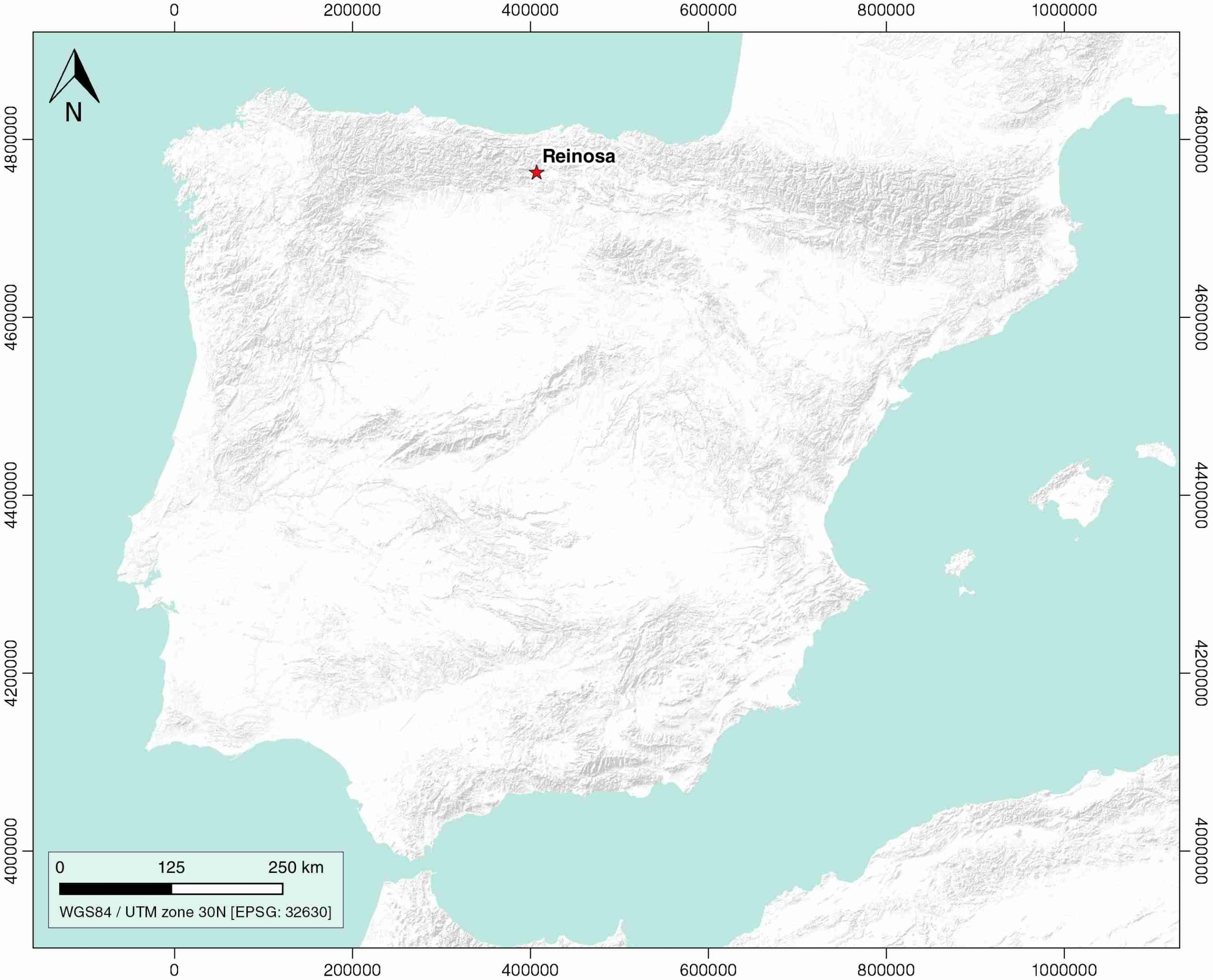
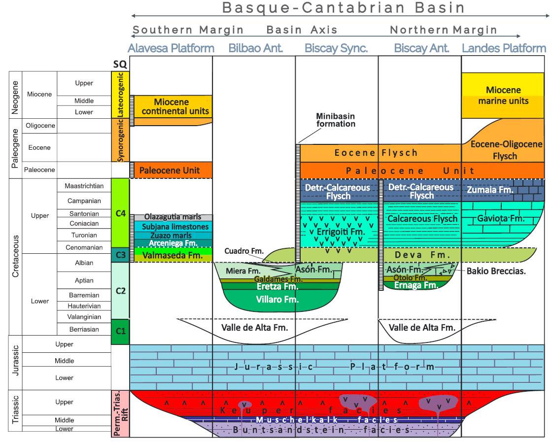
| Geological Setting | Basque-Cantabrian Basin, Burgalesa Platform |
| Outcropping/buried | Outcropping |
| Evaporite unit/s name | Keuper facies |
| Evaporite unit/s age | Carnian-Rhaetian (Upper Triassic) |
| Evaporite unit/s origin | Marine |
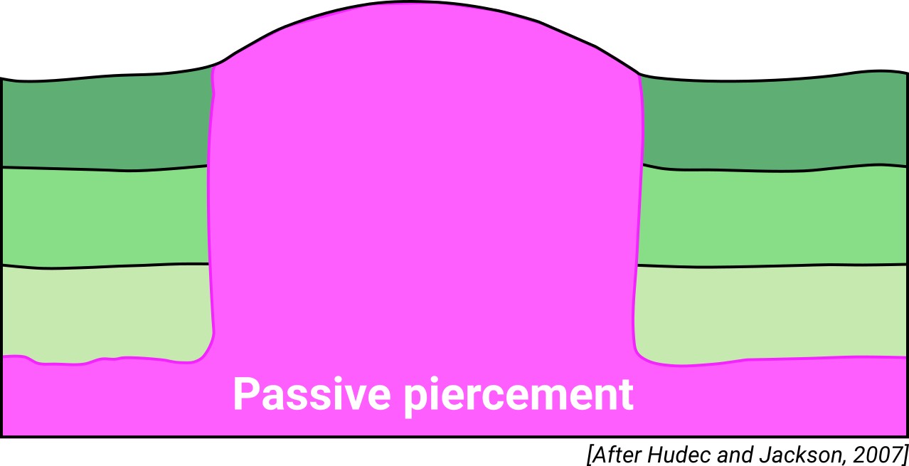
| Classif. (Hudec and Jackson, 2009) | Passive piercement |
| Classif. (Jackson and Talbot, 1986) | Salt wall |
| Age of evaporite flow or deformation (when deformed) | Lower Cretaceous |
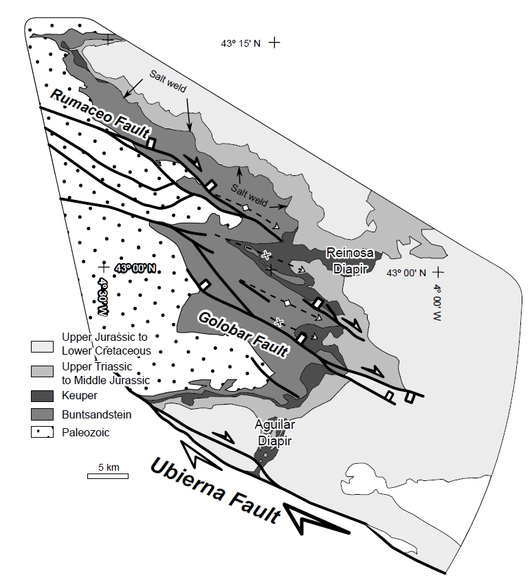
| Other comments | Series of contractional salt structures aligned along the N–S Burgalesa platform boundary: Aguilar, Reinosa and Pas evaporite structures (from south to north). |
Generic Data
| Unique ID | 37 |
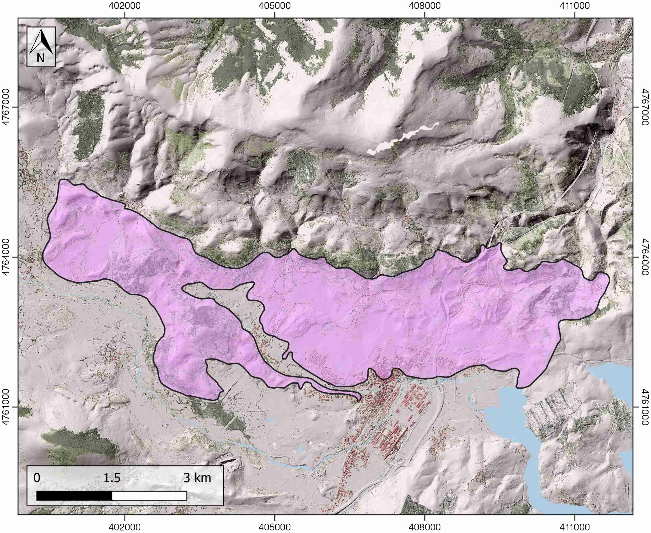
| Name | Reinosa |
| Structure type | Evaporite diapir |
| Deformed/Undeformed | Deformed |
| Buried/Outcropping | Outcropping |
| Geological setting | Basque-Cantabrian Basin |
| Geological Regional Setting | Burgalesa Platform |
| Evaporite unit/s name | Keuper facies |
| Evaporite unit/s age | Carnian-Rhaetian (Upper Triassic) |
| Evaporite unit/s era | Mesozoic |
| Evaporite unit/s origin | Marine |
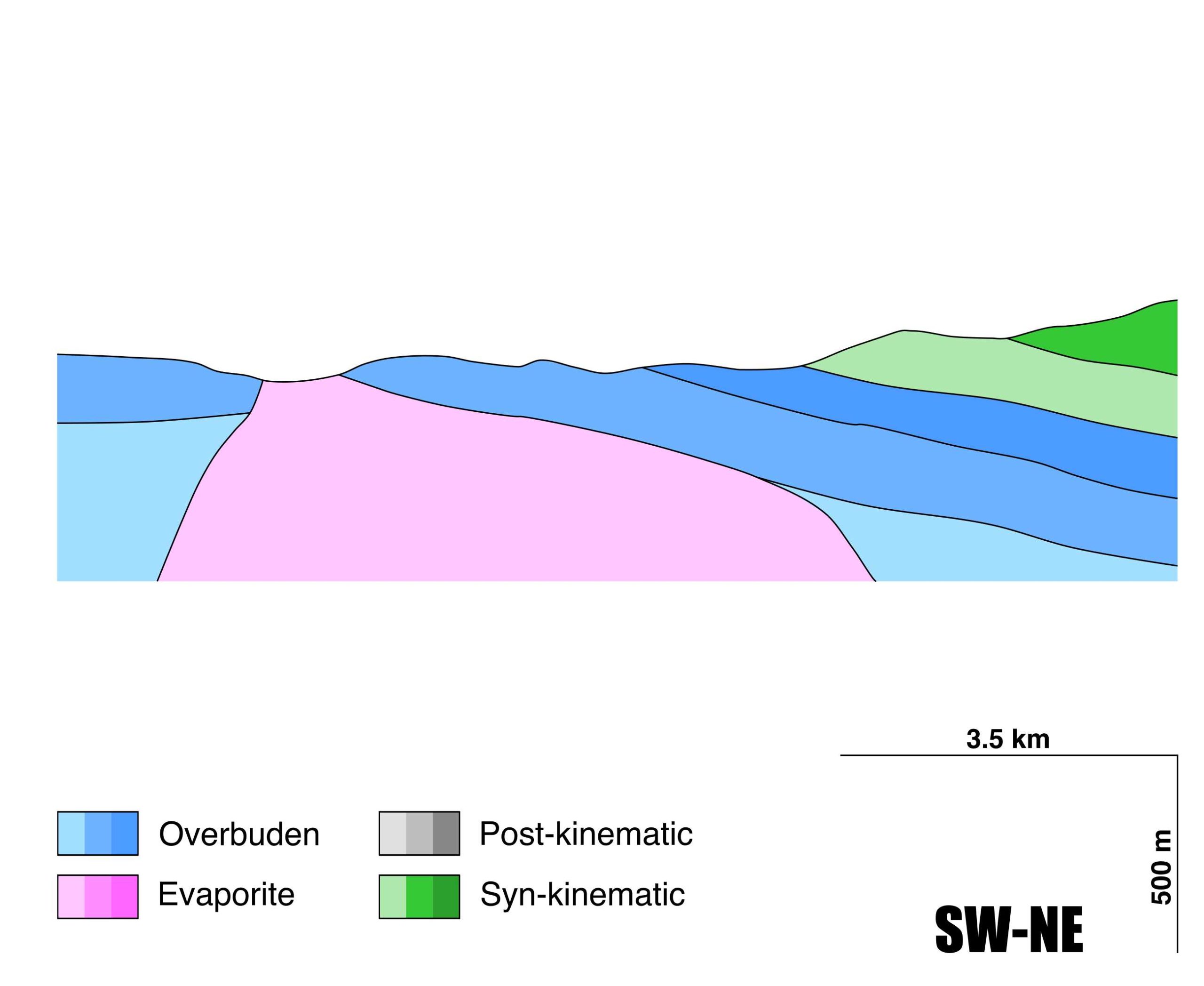
| Evaporite unit/s composition | Gypsum-Halite-Anhydrite-Shales |
| Post-kinematic unit/s (or post-evaporite units when evaporites are undeformed) | Quaternary (alluvial and colluvial detrital deposits) |
| Post-kinematic unit/s age (or post-evaporite units when evaporites are undeformed) | Pleistocene-Holocene |
| Classification (Hudec and Jackson, 2009) | Passive piercement |
| Classification (Jackson and Talbot, 1986) | Salt wall |
| Mining activity? | N |
| Mining activity start | |
| Mining activity end | |
| Mining galleries? | |
| Mining products | |
| Mining sub-products | |
| Evaporite flow? | Y |
| Age of evaporite flow | Barremian – Albian |
| Flow or deformation triggering mechanisms | Rumaceo normal fault |
| Flow-linked structures? | Y |
| Halokinetic structures | Normal high-angle faults / joints |
| Post-evaporite and pre-kinematic unit/s (overbuden) | Jurassic (dolostones, marls and oolitic limestones) |
| Syn-kinematic unit/s | Barremian (Weald facies, limestones, clays and sandstones) / Aptian – Albian (limestones, marls, sandstones and lutites) |
| Available seismic profiles | MARCONI WA / DR-89-02 / DR-89-02 / DR-89-02 / DR-89-02 / DR-89-02 / |
| Available boreholes | FONTIBRE / ORZALES-7 |
| Additional comments | Series of contractional and salt structures aligned along the N–S Burgalesa platform boundary: Aguilar, Reinosa and Pas (from south to north). |
Mining Data
| UNIQUE_ID | 37 |
| Minning exploitations within <2km? | N |
| Historical/Active | |
| Exploitation name #1 | |
| Exploitation ID (Spanish National Mining Cadastre) #1 | |
| Municipality #1 | |
| Province #1 | |
| Company #1 | |
| Main minning Products #1 | |
| Exploitation name #2 | |
| Exploitation ID (Spanish National Mining Cadastre) #2 | |
| Municipality #2 | |
| Province #2 | |
| Company #2 | |
| Main minning Products #2 | |
| Exploitation name #3 | |
| Exploitation ID (Spanish National Mining Cadastre) #3 | |
| Municipality #3 | |
| Province #3 | |
| Company #3 | |
| Main minning Products #3 |
Quantitative Data
| UNIQUE_ID | 37 |
| Outcropping area (km2) | 22.48658 |
| Horizontal intersection area (km2) (when buried) | Not buried |
| Depth of intersection area (km2) (when buried) | Not buried |
| Max. Width (Km) | 4.1 |
| Max. Length (Km) | 11.3 |
| Max. Evaporites thickness (km) | 2 |
| Max. Deformation age (Ma) | 130 |
| Min. Deformation age (Ma) | 100 |
| Deformation stages | 1 |
Reference Data
| UNIQUE_ID | 37 |
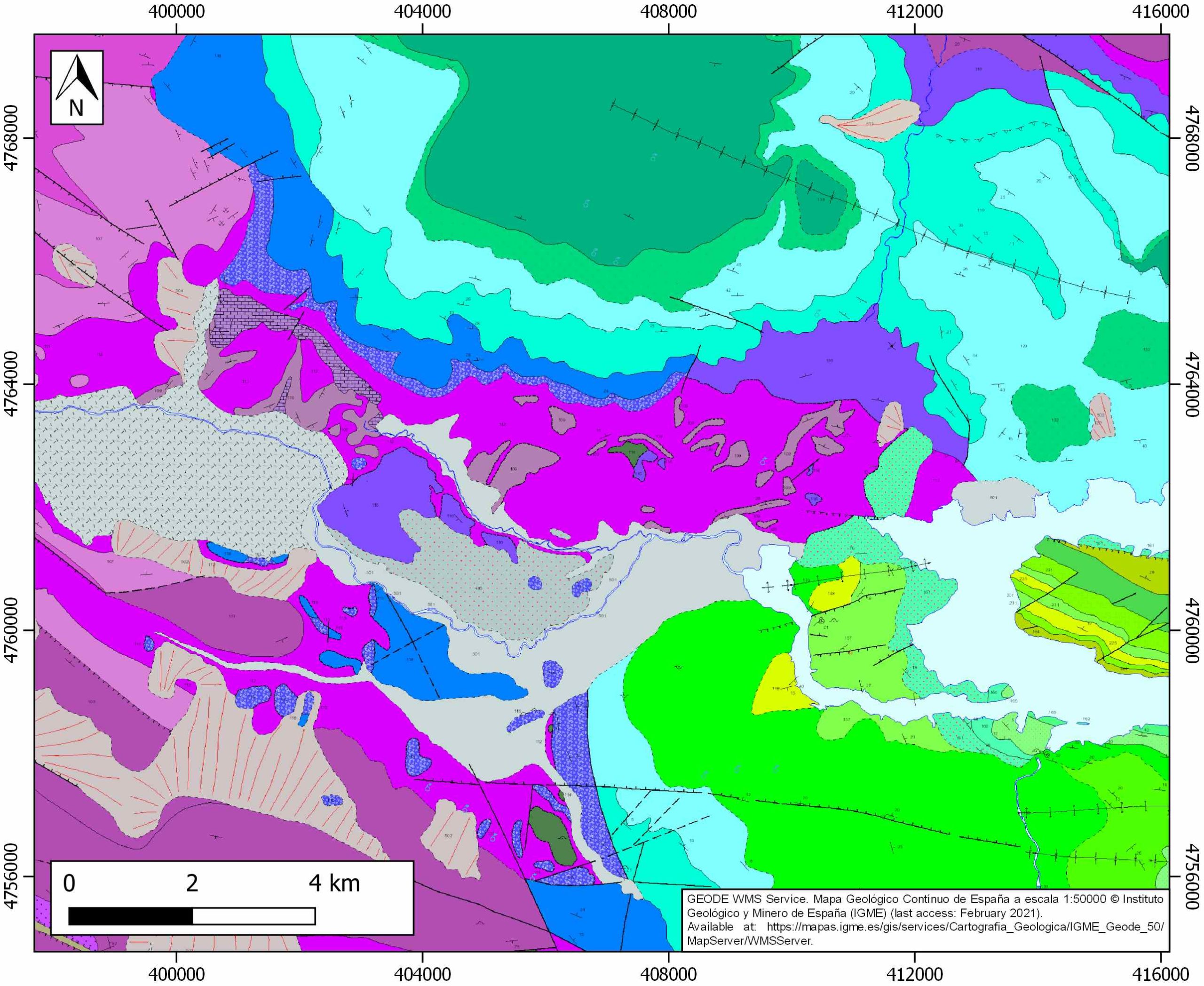
| Section source | IGME MAGNA 50. SHEET 83 (REINOSA) |
| Well / Borehole availability #1 | n.a. |
| Well / Borehole availability #2 | n.a. |
| Available data (Stratigraphy) #1 | Carola, E., Muñoz, J. A., Roca, E., 2015. The transition from thick-skinned to thin-skinned tectonics in the Basque-Cantabrian Pyrenees: The Burgalesa Platform and surroundings. International Journal of Earth Sciences, 104(8), 2215-2239. [link] |
| Available data (Stratigraphy) #2 | Espina, R. G., 1997. La estructura y evolución tectonoestatigráfica del borde occidental de la Cuenca Vasco-Cantábrica (Cordillera Cantábrica, NO de España) [Ph.D. thesis]: Univeridad de Oviedo: 230 p. [link] |
| Available data (Stratigraphy) #3 | Pujalte, V., Robles, S., Mondéjar, J. G., 1986. Características sedimentológicas, secuenciales y tectoestratigráficas del Triásico de Cantabria y norte de Palencia. Cuadernos de Geología Ibérica, 10, 151-172. [link] |
| Available data (Stratigraphy) #4 | López-Gómez, J., Martín-González, F., Heredia, N., de La Horra, R., Barrenechea, J. F., Cadenas, P., Juncal, M., Díez, J. B., Borruel-Abadía, V., Pedreira, B., García-Sansegundo, J., Farias, P., Galé, C., Lago, M., Ubide, T., Fernández-Viejo, G., Gand, G., 2019. New lithostratigraphy for the Cantabrian Mountains: A common tectono-stratigraphic evolution for the onset of the Alpine cycle in the W Pyrenean realm, N Spain. Earth-Science Reviews, 188, 249-271. [link] |
| Available data (Stratigraphy) #5 | Tavani, S., 2012. Plate kinematics in the Cantabrian domain of the Pyrenean orogen. Solid Earth, 3(2), 265. [link] |
| Available data (Stratigraphy) #6 | Soto, R., Casas-Sainz, A. M., Villalaín, J. J., 2011. Widespread Cretaceous inversion event in northern Spain: evidence from subsurface and palaeomagnetic data. Journal of the Geological Society, 168(4), 899-912. [link] |
| Regional Stratigraphy | Pedrera, A., García‐Senz, J., Ayala, C., Ruiz‐Constán, A., Rodríguez‐Fernández, L. R., Robador, A., González Menéndez, L., 2017. Reconstruction of the exhumed mantle across the North Iberian Margin by crustal‐scale 3‐D gravity inversion and geological cross section. Tectonics, 36, 3155-3177. [link] |
| Seismic data availability #1 | Soto, R., Casas-Sainz, A. M., Villalaín, J. J., 2011. Widespread Cretaceous inversion event in northern Spain: evidence from subsurface and palaeomagnetic data. Journal of the Geological Society, 168(4), 899-912. [link] |
| Seismic data availability #2 | Carola, E., Muñoz, J. A., Roca, E., 2015. The transition from thick-skinned to thin-skinned tectonics in the Basque-Cantabrian Pyrenees: The Burgalesa Platform and surroundings. International Journal of Earth Sciences, 104(8), 2215-2239. [link] |
| Seismic data availability #3 | Gallart Muset, J., Pulgar, J. A., Muñoz, J. A., Diaz, J., Ruiz Fernández, M., 2020. Litospheric Structure of the North Iberian Margin: MARCONI-WA reflection profiles. DigitalCSIC – SEISDARE data repository. [link] |
| Available data (Structure) #1 | Carola, E., Muñoz, J. A., Roca, E., 2015. The transition from thick-skinned to thin-skinned tectonics in the Basque-Cantabrian Pyrenees: The Burgalesa Platform and surroundings. International Journal of Earth Sciences, 104(8), 2215-2239. [link] |
| Available data (Structure) #2 | Tavani, S., 2012. Plate kinematics in the Cantabrian domain of the Pyrenean orogen. Solid Earth, 3(2), 265. [link] |
| Available data (Structure) #3 | Espina, R. G., 1997. La estructura y evolución tectonoestatigráfica del borde occidental de la Cuenca Vasco-Cantábrica (Cordillera Cantábrica, NO de España) [Ph.D. thesis]: Univeridad de Oviedo: 230 p. [link] |
| Available data (Structure) #4 | Tavani, S., Carola, E., Granado, P., Quintà, A., Muñoz, J. A., 2013. Transpressive inversion of a Mesozoic extensional forced fold system with an intermediate décollement level in the Basque‐Cantabrian Basin (Spain). Tectonics, 32(2), 146-158. [link] |
| Available data (Structure) #5 | Tavani, S., Granado, P., 2015. Along‐strike evolution of folding, stretching and breaching of supra‐salt strata in the Plataforma Burgalesa extensional forced fold system (northern Spain). Basin Research, 27(4), 573-585. [link] |
| Available data (Structure) #6 | Soto, R., Casas-Sainz, A. M., Villalaín, J. J., 2011. Widespread Cretaceous inversion event in northern Spain: evidence from subsurface and palaeomagnetic data. Journal of the Geological Society, 168(4), 899-912. [link] |
| Available data (Analogue modelling) #1 | n.a. |
| Available data (Analogue modelling) #2 | n.a. |
| Available data (Analogue modelling) #3 | n.a. |
| Available data (Gravimetry – Tomography) #1 | Pedrera, A., García‐Senz, J., Ayala, C., Ruiz‐Constán, A., Rodríguez‐Fernández, L. R., Robador, A., González Menéndez, L., 2017. Reconstruction of the exhumed mantle across the North Iberian Margin by crustal‐scale 3‐D gravity inversion and geological cross section. Tectonics, 36, 3155-3177. [link] |
| Available data (Gravimetry – Tomography) #2 | Ayala, C., Bohoyo, F., Maestro, A., Reguera, M. I., Torne, M., Rubio, F., Fernández, M., García-Lobón, J. L., 2016. Updated Bouguer anomalies of the Iberian Peninsula: a new perspective to interpret the regional geology. Journal of Maps, 12(5), 1089-1092. [link] |
| Available data (Gravimetry – Tomography) #3 | n.a. |
| Available data (Geochemistry) #1 | Béziat, D., Joron, J.L., Monchoux, P., Treuil, M., Walgenwitz, F., 1991. Geodynamic implications of geochemical data for the Pyrenean ophites (Spain-France). Chemical Geology, 89, 243-262. [link] |
| Available data (Geochemistry) #2 | Ortí, F., García-Veigas, J., Rossell, L., Jurado, M. J., Utrilla, R., 1996. Formaciones salinas de las cuencas triásicas en la Península Ibérica: Caracterización Petrológica y Geoquímica. Cuadernos de Geología Ibérica, 20, 13-35. [link] |
| Available data (Geochemistry) #3 | Iribar, V., Ábalos, B. 2011. The geochemical and isotopic record of evaporite recycling in spas and salterns of the Basque Cantabrian basin, Spain. Applied geochemistry, 26, 1315-1329. [link] |
| Available data (Geochemistry) #4 | n.a. |
| Available data (Petrophysics) #1 | Soto, R., Casas-Sainz, A. M., Villalaín J. J., Gil-Imaz, A., Fernandez-Gonzalez, G., Del Rio, P., Calvo, M., Mochales, T., 2008. Characterizing the Mesozoic extension direction in the northern Iberian plate margin by anisotropy of magnetic susceptibility (AMS). Journal of the Geological Society, 165(6), 1007-1018. [link] |
| Available data (Petrophysics) #2 | n.a. |
| IGME Geological Map (MAGNA50) Sheet number | 83-Reinosa. [link] |
| Other Maps #1 (source) | Perona, J., 2016. Mineralizaciones de Pb-Zn asociadas a los diapiros de Murguía y Orduña (Cuenca Vasco-Cantábrica) [PhD thesis]: Barcelona, Universitat de Barcelona, 281 pp. [link] |
| Other Maps #2 (source) | Tavani, S., 2012. Plate kinematics in the Cantabrian domain of the Pyrenean orogen. Solid Earth, 3(2), 265. [link] |
| Other related references #1 | Calvet, F., de Porta, N. S., Salvany, J. M., 1993. Cronoestratigrafía (Palinología) del Triásico Sudpirenaico y del Pirineo Vasco-Cantábrico. Acta geológica hispánica, 33-48. [link] |
| Other related references #2 | Cámara, P., 2017. Salt and Strike-Slip Tectonics as Main Drivers in the Structural Evolution of the Basque-Cantabrian Basin, Spain. In Permo-Triassic Salt Provinces of Europe, North Africa and the Atlantic Margins (pp. 371-393). Elsevier. [link] |
| Other related references #3 | n.a. |
| Other related references #4 | n.a. |
Well and Seismic Data
| UNIQUE_ID | 37 |
| Seismic survey name #1 | MARCONI WA |
| Across structure? #1 | Y |
| Seismic profile ID (IGME) #1 | n.a. |
| Seismic profile code #1 | n.a. |
| Seismic profile name #1 | n.a. |
| Seismic survey year #1 | n.a. |
| Data repository #1 | SeisDARE Database: https://digital.csic.es/handle/10261/101879 |
| Length (km) #1 | 69.02 |
| Seismic survey name #2 | 0552A89G |
| Across structure? #2 | Y |
| Seismic profile ID (IGME) #2 | 201 |
| Seismic profile code #2 | 1046 |
| Seismic profile name #2 | DR-89-02 |
| Seismic survey year #2 | 1989 |
| Data repository #2 | SIGEOF Data Catalogue (Section available under request). ©Instituto Geológico y Minero de España (IGME). https://info.igme.es/SIGEOF/ |
| Length (km) #2 | 11.88 |
| Seismic survey name #3 | 0552A89S |
| Across structure? #3 | Y |
| Seismic profile ID (IGME) #3 | 210 |
| Seismic profile code #3 | 1055 |
| Seismic profile name #3 | DR-89-02 |
| Seismic survey year #3 | 1989 |
| Data repository #3 | SIGEOF Data Catalogue (Section available under request). ©Instituto Geológico y Minero de España (IGME). https://info.igme.es/SIGEOF/ |
| Length (km) #3 | 7.33 |
| Seismic survey name #4 | 0552A89S |
| Across structure? #4 | N (within 3km) |
| Seismic profile ID (IGME) #4 | 210 |
| Seismic profile code #4 | 1055 |
| Seismic profile name #4 | DR-89-02 |
| Seismic survey year #4 | 1989 |
| Data repository #4 | SIGEOF Data Catalogue (Section available under request). ©Instituto Geológico y Minero de España (IGME). https://info.igme.es/SIGEOF/ |
| Length (km) #4 | 7.33 |
| Seismic survey name #5 | 0552A89S |
| Across structure? #5 | N (within 3km) |
| Seismic profile ID (IGME) #5 | 209 |
| Seismic profile code #5 | 1054 |
| Seismic profile name #5 | DR-89-02 |
| Seismic survey year #5 | 1989 |
| Data repository #5 | SIGEOF Data Catalogue (Section available under request). ©Instituto Geológico y Minero de España (IGME). https://info.igme.es/SIGEOF/ |
| Length (km) #5 | 21.59 |
| Seismic survey name #6 | 0552A89G |
| Across structure? #6 | N (within 3km) |
| Seismic profile ID (IGME) #6 | 201 |
| Seismic profile code #6 | 1046 |
| Seismic profile name #6 | DR-89-02 |
| Seismic survey year #6 | 1989 |
| Data repository #6 | SIGEOF Data Catalogue (Section available under request). ©Instituto Geológico y Minero de España (IGME). https://info.igme.es/SIGEOF/ |
| Length (km) #6 | 11.88 |
| Seismic survey name #7 | |
| Across structure? #7 | |
| Seismic profile ID (IGME) #7 | |
| Seismic profile code #7 | |
| Seismic profile name #7 | |
| Seismic survey year #7 | |
| Data repository #7 | |
| Length (km) #7 | |
| Seismic survey name #8 | |
| Across structure? #8 | |
| Seismic profile ID (IGME) #8 | |
| Seismic profile code #8 | |
| Seismic profile name #8 | |
| Seismic survey year #8 | |
| Data repository #8 | |
| Length (km) #8 | |
| Seismic survey name #9 | |
| Across structure? #9 | |
| Seismic profile ID (IGME) #9 | |
| Seismic profile code #9 | |
| Seismic profile name #9 | |
| Seismic survey year #9 | |
| Data repository #9 | |
| Length (km) #9 | |
| Seismic survey name #10 | |
| Across structure? #10 | |
| Seismic profile ID (IGME) #10 | |
| Seismic profile code #10 | |
| Seismic profile name #10 | |
| Seismic survey year #10 | |
| Data repository #10 | |
| Length (km) #10 | |
| Seismic survey name #11 | |
| Across structure? #11 | |
| Seismic profile ID (IGME) #11 | |
| Seismic profile code #11 | |
| Seismic profile name #11 | |
| Seismic survey year #11 | |
| Data repository #11 | |
| Length (km) #11 | |
| Seismic survey name #12 | |
| Across structure? #12 | |
| Seismic profile ID (IGME) #12 | |
| Seismic profile code #12 | |
| Seismic profile name #12 | |
| Seismic survey year #12 | |
| Data repository #12 | |
| Length (km) #12 | |
| Seismic survey name #13 | |
| Across structure? #13 | |
| Seismic profile ID (IGME) #13 | |
| Seismic profile code #13 | |
| Seismic profile name #13 | |
| Seismic survey year #13 | |
| Data repository #13 | |
| Length (km) #13 | |
| Seismic survey name #14 | |
| Across structure? #14 | |
| Seismic profile ID (IGME) #14 | |
| Seismic profile code #14 | |
| Seismic profile name #14 | |
| Seismic survey year #14 | |
| Data repository #14 | |
| Length (km) #14 | |
| Seismic survey name #15 | |
| Across structure? #15 | |
| Seismic profile ID (IGME) #15 | |
| Seismic profile code #15 | |
| Seismic profile name #15 | |
| Seismic survey year #15 | |
| Data repository #15 | |
| Length (km) #15 | |
| Seismic survey name #16 | |
| Across structure? #16 | |
| Seismic profile ID (IGME) #16 | |
| Seismic profile code #16 | |
| Seismic profile name #16 | |
| Seismic survey year #16 | |
| Data repository #16 | |
| Length (km) #16 | |
| Seismic survey name #17 | |
| Across structure? #17 | |
| Seismic profile ID (IGME) #17 | |
| Seismic profile code #17 | |
| Seismic profile name #17 | |
| Seismic survey year #17 | |
| Data repository #17 | |
| Length (km) #17 | |
| Seismic survey name #18 | |
| Across structure? #18 | |
| Seismic profile ID (IGME) #18 | |
| Seismic profile code #18 | |
| Seismic profile name #18 | |
| Seismic survey year #18 | |
| Data repository #18 | |
| Length (km) #18 | |
| Seismic survey name #19 | |
| Across structure? #19 | |
| Seismic profile ID (IGME) #19 | |
| Seismic profile code #19 | |
| Seismic profile name #19 | |
| Seismic survey year #19 | |
| Data repository #19 | |
| Length (km) #19 | |
| Seismic survey name #20 | |
| Across structure? #20 | |
| Seismic profile ID (IGME) #20 | |
| Seismic profile code #20 | |
| Seismic profile name #20 | |
| Seismic survey year #20 | |
| Data repository #20 | |
| Length (km) #20 | |
| Seismic survey name #21 | |
| Across structure? #21 | |
| Seismic profile ID (IGME) #21 | |
| Seismic profile code #21 | |
| Seismic profile name #21 | |
| Seismic survey year #21 | |
| Data repository #21 | |
| Length (km) #21 | |
| Borehole name #1 | FONTIBRE |
| Company #1 | CONFEDERACION HIDROGRAFICA DEL EBRO |
| Traget #1 | HYDROGEOLOGY |
| Across structure? #1 | Y |
| Borehole name #2 | ORZALES-7 |
| Company #2 | IGME |
| Traget #2 | INDUSTRIAL ROCKS |
| Across structure? #2 | N (within 5 km) |
| Borehole name #3 | |
| Company #3 | |
| Traget #3 | |
| Across structure? #3 | |
| Borehole name #4 | |
| Company #4 | |
| Traget #4 | |
| Across structure? #4 | |
| Borehole name #5 | |
| Company #5 | |
| Traget #5 | |
| Across structure? #5 | |
| Borehole name #6 | |
| Company #6 | |
| Traget #6 | |
| Across structure? #6 | |
| Borehole name #7 | |
| Company #7 | |
| Traget #7 | |
| Across structure? #7 | |
| Borehole name #8 | |
| Company #8 | |
| Traget #8 | |
| Across structure? #8 | |
| Borehole name #9 | |
| Company #9 | |
| Traget #9 | |
| Across structure? #9 | |
| Borehole name #10 | |
| Company #10 | |
| Traget #10 | |
| Across structure? #10 | |
| Borehole name #11 | |
| Company #11 | |
| Traget #11 | |
| Across structure? #11 | |
| Borehole name #12 | |
| Company #12 | |
| Traget #12 | |
| Across structure? #12 | |
| Borehole name #13 | |
| Company #13 | |
| Traget #13 | |
| Across structure? #13 | |
| Borehole name #14 | |
| Company #14 | |
| Traget #14 | |
| Across structure? #14 | |
| Borehole name #15 | |
| Company #15 | |
| Traget #15 | |
| Across structure? #15 |
Geographical Data (EPSG:4326 - WGS 84)
| UNIQUE_ID | 37 |
| X Centroid (Structure shape) | -4.154268 |
| Y Centroid (Structure shape) | -4.154268 |
| Xmin (Structure shape) | -4.222914 |
| Xmax (Structure shape) | -4.083679 |
| Ymin (Structure shape) | 42.996744 |
| Ymax (Structure shape) | 43.036204 |
| Xmin seismic line #1 | -4.179500 |
| Xmax seismic line #1 | -3.990300 |
| Ymin seismic line #1 | 42.824000 |
| Ymax seismic line #1 | 43.421000 |
| Xmin seismic line #2 | -4.266409 |
| Xmax seismic line #2 | -4.154072 |
| Ymin seismic line #2 | 43.000876 |
| Ymax seismic line #2 | 43.051797 |
| Xmin seismic line #3 | -4.233019 |
| Xmax seismic line #3 | -4.154267 |
| Ymin seismic line #3 | 43.000986 |
| Ymax seismic line #3 | 43.023017 |
| Xmin seismic line #4 | -4.233019 |
| Xmax seismic line #4 | -4.154267 |
| Ymin seismic line #4 | 43.000986 |
| Ymax seismic line #4 | 43.023017 |
| Xmin seismic line #5 | -4.439859 |
| Xmax seismic line #5 | -4.233019 |
| Ymin seismic line #5 | 43.023017 |
| Ymax seismic line #5 | 43.085240 |
| Xmin seismic line #6 | -4.266409 |
| Xmax seismic line #6 | -4.154072 |
| Ymin seismic line #6 | 43.000876 |
| Ymax seismic line #6 | 43.051797 |
| Xmin seismic line #7 | |
| Xmax seismic line #7 | |
| Ymin seismic line #7 | |
| Ymax seismic line #7 | |
| Xmin seismic line #8 | |
| Xmax seismic line #8 | |
| Ymin seismic line #8 | |
| Ymax seismic line #8 | |
| Xmin seismic line #9 | |
| Xmax seismic line #9 | |
| Ymin seismic line #9 | |
| Ymax seismic line #9 | |
| Xmin seismic line #10 | |
| Xmax seismic line #10 | |
| Ymin seismic line #10 | |
| Ymax seismic line #10 | |
| Xmin seismic line #11 | |
| Xmax seismic line #11 | |
| Ymin seismic line #11 | |
| Ymax seismic line #11 | |
| Xmin seismic line #12 | |
| Xmax seismic line #12 | |
| Ymin seismic line #12 | |
| Ymax seismic line #12 | |
| Xmin seismic line #13 | |
| Xmax seismic line #13 | |
| Ymin seismic line #13 | |
| Ymax seismic line #13 | |
| Xmin seismic line #14 | |
| Xmax seismic line #14 | |
| Ymin seismic line #14 | |
| Ymax seismic line #14 | |
| Xmin seismic line #15 | |
| Xmax seismic line #15 | |
| Ymin seismic line #15 | |
| Ymax seismic line #15 | |
| Xmin seismic line #16 | |
| Xmax seismic line #16 | |
| Ymin seismic line #16 | |
| Ymax seismic line #16 | |
| Xmin seismic line #17 | |
| Xmax seismic line #17 | |
| Ymin seismic line #17 | |
| Ymax seismic line #17 | |
| Xmin seismic line #18 | |
| Xmax seismic line #18 | |
| Ymin seismic line #18 | |
| Ymax seismic line #18 | |
| Xmin seismic line #19 | |
| Xmax seismic line #19 | |
| Ymin seismic line #19 | |
| Ymax seismic line #19 | |
| Xmin seismic line #20 | |
| Xmax seismic line #20 | |
| Ymin seismic line #20 | |
| Ymax seismic line #20 | |
| Xmin seismic line #21 | |
| Xmax seismic line #21 | |
| Ymin seismic line #21 | |
| Ymax seismic line #21 | |
| X borehole #1 | -4.194684 |
| Y borehole #1 | 43.014721 |
| X borehole #2 | -4.079548 |
| Y borehole #2 | 42.994775 |
| X borehole #3 | |
| Y borehole #3 | |
| X borehole #4 | |
| Y borehole #4 | |
| X borehole #5 | |
| Y borehole #5 | |
| X borehole #6 | |
| Y borehole #6 | |
| X borehole #7 | |
| Y borehole #7 | |
| X borehole #8 | |
| Y borehole #8 | |
| X borehole #9 | |
| Y borehole #9 | |
| X borehole #10 | |
| Y borehole #10 | |
| X borehole #11 | |
| Y borehole #11 | |
| X borehole #12 | |
| Y borehole #12 | |
| X borehole #13 | |
| Y borehole #13 | |
| X borehole #14 | |
| Y borehole #14 | |
| X borehole #15 | |
| Y borehole #15 |

