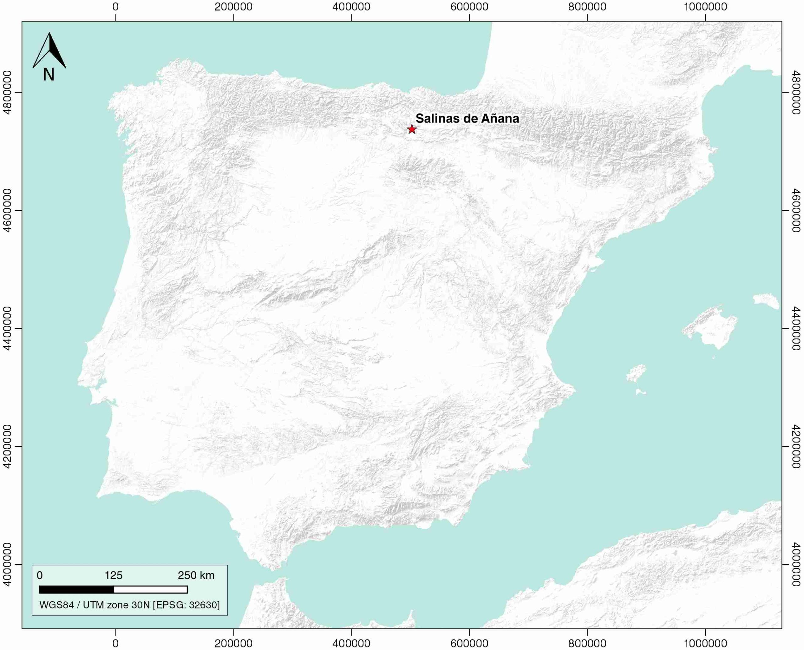
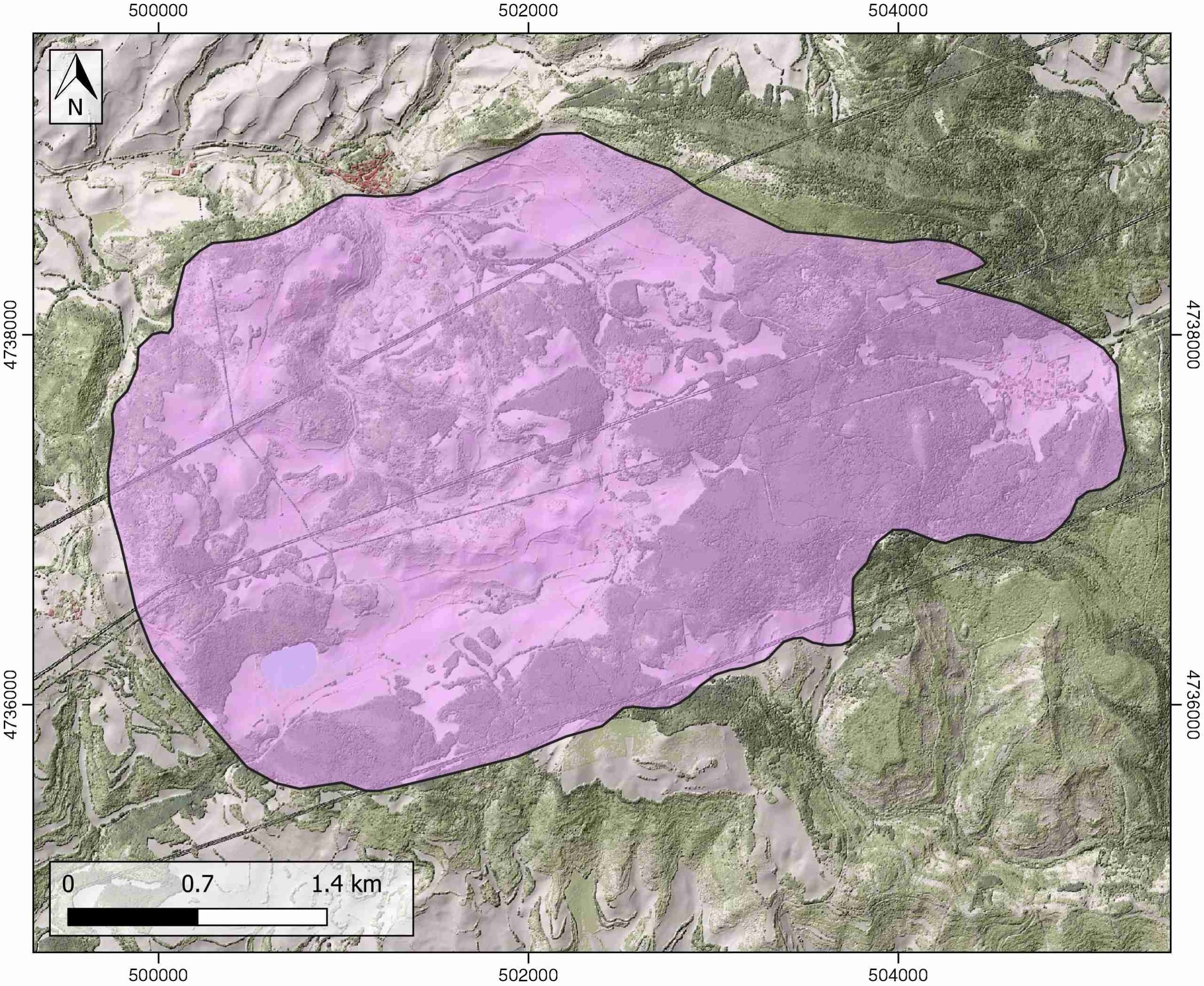
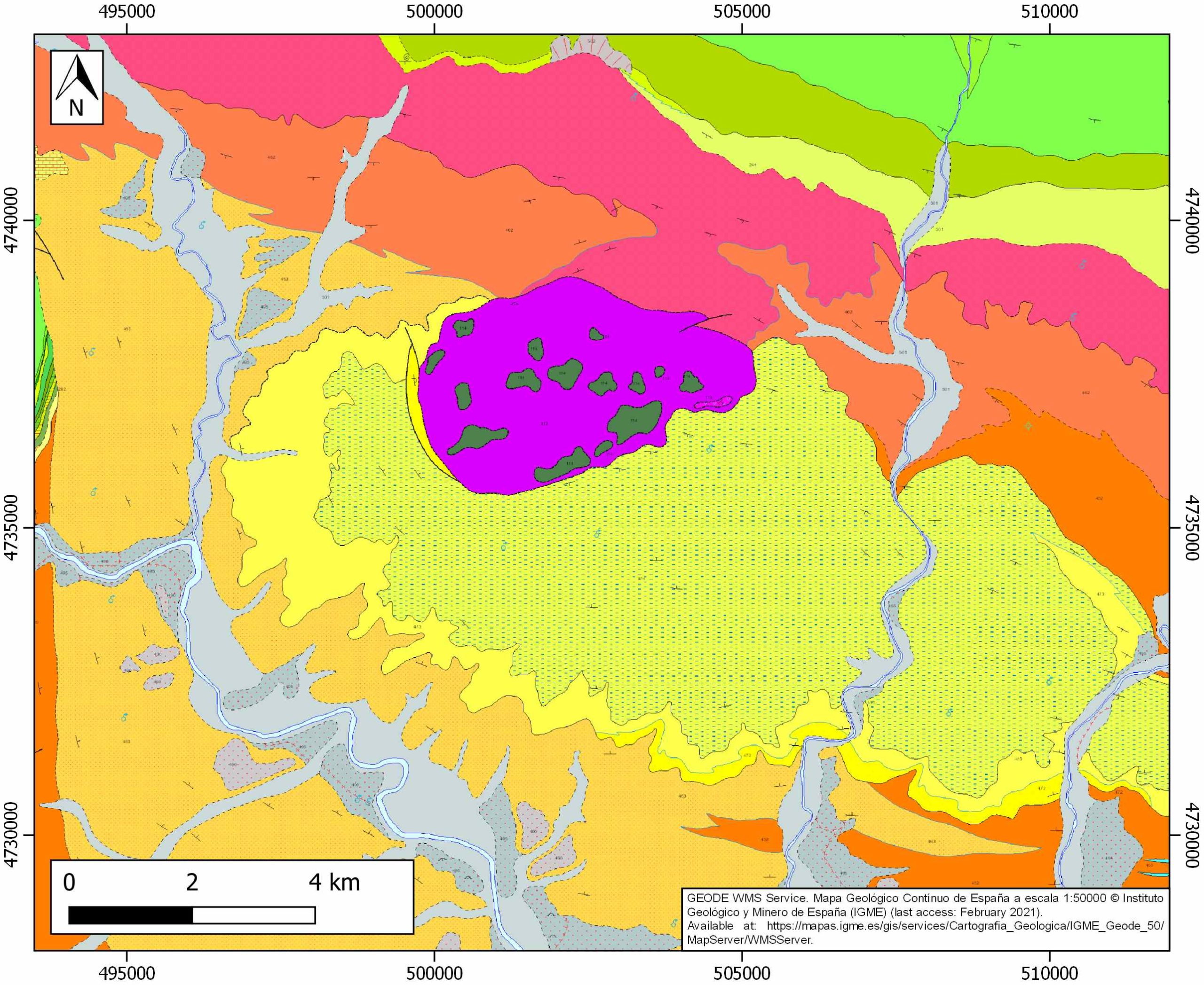
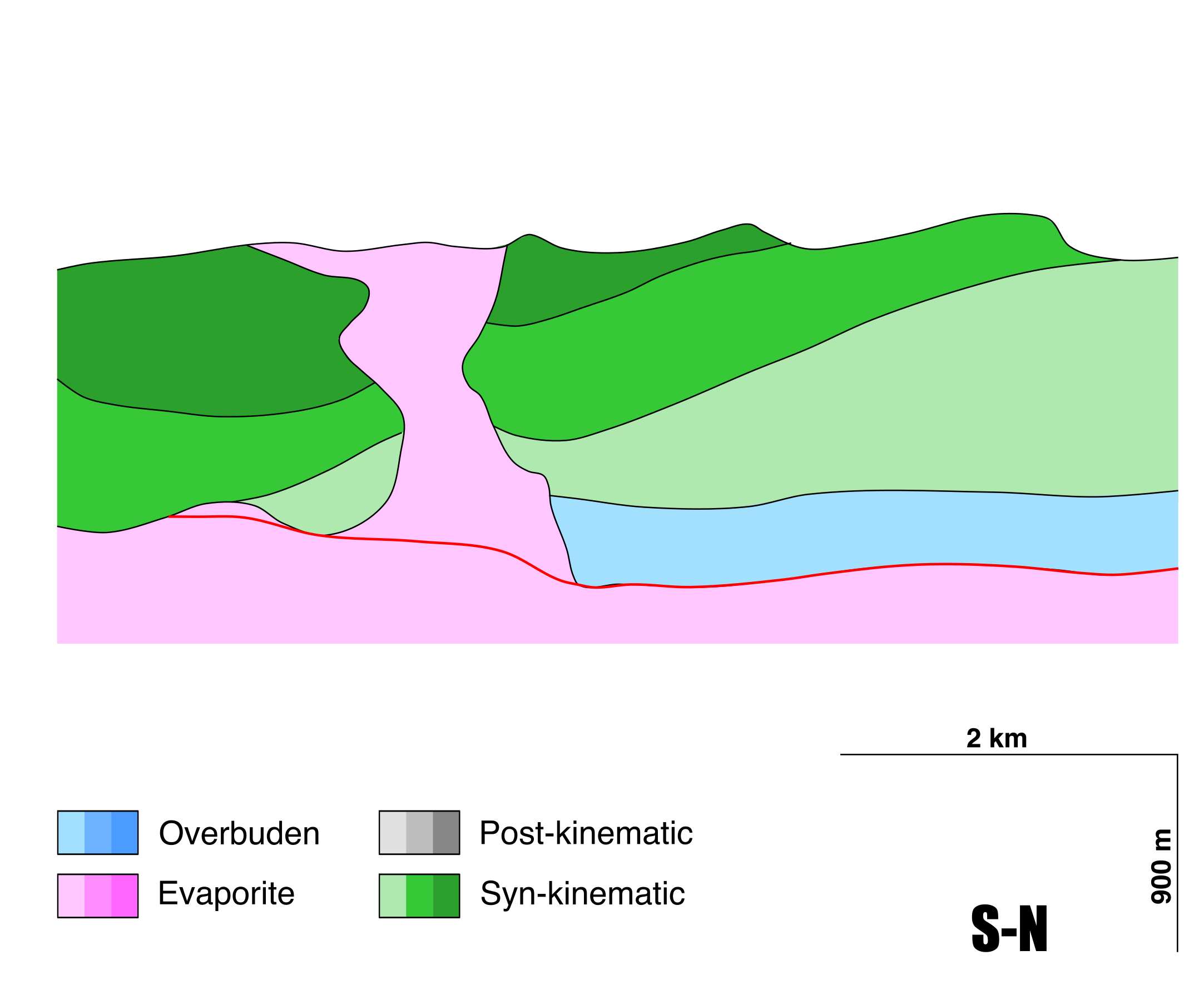
Salinas de Añana
ID #017
General Information
| Structure type | Evaporite Diapir |
| Deformed/Undeformed | Deformed |
| Geological Setting | Basque-Cantabrian Basin, Navarra-Álava trough |
| Outcropping/buried | Outcropping |
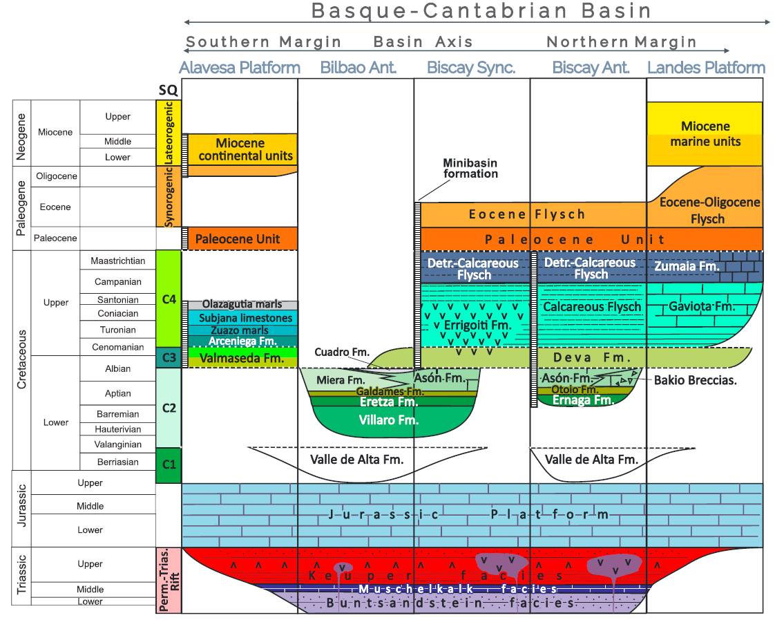
| Evaporite unit/s name | Keuper facies |
| Evaporite unit/s age | Carnian-Rhaetian (Upper Triassic) |
| Evaporite unit/s origin | Marine |
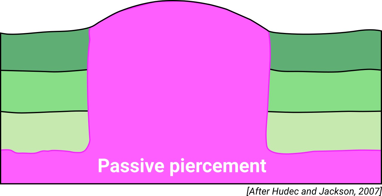
| Classif. (Hudec and Jackson, 2009) | Passive piercement |
| Classif. (Jackson and Talbot, 1986) | Salt stock |
| Age of evaporite flow or deformation (when deformed) | Aptian to Quaternary |
| Other comments |
Generic Data
| Unique ID | 17 |
| Name | Salinas de Añana |
| Structure type | Evaporite diapir |
| Deformed/Undeformed | Deformed |
| Buried/Outcropping | Outcropping |
| Geological setting | Basque-Cantabrian Basin |
| Geological Regional Setting | Navarra-Álava trough |
| Evaporite unit/s name | Keuper facies |
| Evaporite unit/s age | Carnian-Rhaetian (Upper Triassic) |
| Evaporite unit/s era | Mesozoic |
| Evaporite unit/s origin | Marine |
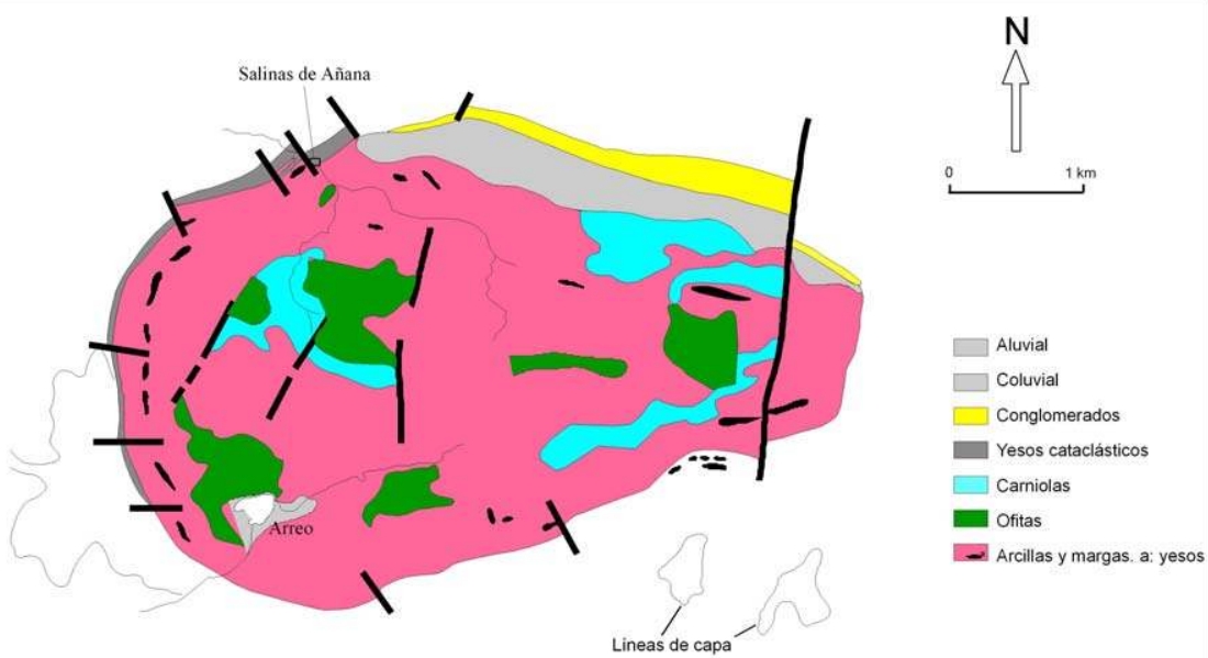
| Evaporite unit/s composition | Claystonestone-Marlstone-Gypsum |
| Post-kinematic unit/s (or post-evaporite units when evaporites are undeformed) | Quaternary (alluvial and colluvial detrital deposits) |
| Post-kinematic unit/s age (or post-evaporite units when evaporites are undeformed) | Holocene |
| Classification (Hudec and Jackson, 2009) | Passive piercement |
| Classification (Jackson and Talbot, 1986) | Salt stock |
| Mining activity? | Y |
| Mining activity start | Roman Empire |
| Mining activity end | Active |
| Mining galleries? | N |
| Mining products | Potassium salt ; halite ; gypsum |
| Mining sub-products | |
| Evaporite flow? | Y |
| Age of evaporite flow | Aptian – Active now |
| Flow or deformation triggering mechanisms | Sierra Cantabria thrust |
| Flow-linked structures? | Y |
| Halokinetic structures | Normal Faults / Reverse faults / Progressive unconformities / Hook-type structures |
| Post-evaporite and pre-kinematic unit/s (overbuden) | Jurassic (limestones and marls) and Lower Cretaceous (clastic deposits) |
| Syn-kinematic unit/s | Albo-Cenomanian (Valmaseda Fm.) / Cenomanian (marls and limestones) / Turonian (Gárate limestones Fm.) / Middle-Upper Turonian (Zuazo marls Fm.) / Lower Coniacian (Subijana limestones) / Coniacian-Lower Santonian (Osma marls Fm.) / Santonian (marls and limestones) / Lower Miocene (Conglomerates, sandstones and marls) |
| Available seismic profiles | SA-1 / SA-3 / SA-2 / P-23 / SA-4 / SA81-03 / ZU-1 / SA81-04 / SA-4 / SA-5 / ZU-2 / SA-2 / SA81-03 / ZU-4 / SA-3 / ZU-5 / SA81-01 / SA-1 / ZU-4 / SA81-02 / SA81-04 |
| Available boreholes | (Private Access): ANTEZANA-1 / POBES / SUBIJANA-3 / SUBIJANA-4 |
| Additional comments | Other seismic profiles (private access, carried out by CIEPS, Repsol and Elf Aquitania) are mapped in Frankovic et al. (2016) |
Mining Data
| UNIQUE_ID | 17 |
| Minning exploitations within <2km? | Y |
| Historical/Active | Historical (not indexed in the Spanish National Minning Cadastre) |
| Exploitation name #1 | n.a. |
| Exploitation ID (Spanish National Mining Cadastre) #1 | n.a. |
| Municipality #1 | n.a. |
| Province #1 | n.a. |
| Company #1 | n.a. |
| Main minning Products #1 | Potassium salt ; halite ; gypsum |
| Exploitation name #2 | |
| Exploitation ID (Spanish National Mining Cadastre) #2 | |
| Municipality #2 | |
| Province #2 | |
| Company #2 | |
| Main minning Products #2 | |
| Exploitation name #3 | |
| Exploitation ID (Spanish National Mining Cadastre) #3 | |
| Municipality #3 | |
| Province #3 | |
| Company #3 | |
| Main minning Products #3 |
Quantitative Data
| UNIQUE_ID | 17 |
| Outcropping area (km2) | 13.02254 |
| Horizontal intersection area (km2) (when buried) | Not buried |
| Depth of intersection area (km2) (when buried) | Not buried |
| Max. Width (Km) | 3.2 |
| Max. Length (Km) | 5.4 |
| Max. Evaporites thickness (km) | 1.5 |
| Max. Deformation age (Ma) | 113 |
| Min. Deformation age (Ma) | Active |
| Deformation stages | 1 |
Reference Data
| UNIQUE_ID | 17 |
| Section source | Frankovic, A., Eguiluz, L., Martínez-Torres, L. M., 2016. Geodynamic evolution of the Salinas de Añana diapir in the Basque-Cantabrian basin, western Pyrenees. Journal of Structural Geology, 83, 13-27. [link] |
| Well / Borehole availability #1 | Frankovic, A., Eguiluz, L., Martínez-Torres, L. M., 2016. Geodynamic evolution of the Salinas de Añana diapir in the Basque-Cantabrian basin, western Pyrenees. Journal of Structural Geology, 83, 13-27. [link] |
| Well / Borehole availability #2 | n.a. |
| Available data (Stratigraphy) #1 | Robles, S., 2014. Evolución geológica de la Cuenca Vasco-Cantábrica. Geología de la Cuenca Vasco-Cantábrica. Bilbao: Servicio editorial de la Universidad del País Vasco, 9-104. [link] |
| Available data (Stratigraphy) #2 | Martínez-Torres, L. M., 1993. Corte balanceado de la Sierra Cantabria (cabalgamiento de la Cuenca Vasco-Cantábrica sobre la Cuenca del Ebro). Geogaceta, 14, 113-115. [link] |
| Available data (Stratigraphy) #3 | Bodego, A., Agirrezabala, L. M., 2013. Syn‐depositional thin‐and thick‐skinned extensional tectonics in the mid‐Cretaceous Lasarte sub‐basin, western Pyrenees. Basin Research, 25(5), 594-612. [link] |
| Available data (Stratigraphy) #4 | Frankovic, A., 2011. Analisis cinematico de la pared de sal Euskal Balea (Golfo de Vizcaya) y de los diapiros salinos de Salinas de Añana y Maestu (Cuenca Vasco-Cantabrica, Alava) [Ph.D thesis]: Universidad del País Vasco UPV-EHU, Bilbao. [link] |
| Available data (Stratigraphy) #5 | Eguiluz, L., Llanos, H., 1988. El diapiro de Salinas de A~nana: Un ejemplo de ascenso diapírico modificado por esfuerzos cizallantes. Actas II Congr. Geol. España 2, 131-134. [link] |
| Available data (Stratigraphy) #6 | García-Mondejar, J., Aguirrezabalaga, L.M., Aramburu, A., Fernandez-Mendiola, P.A., Gomez-Perez, I., Lopez-Horgue, M., Corrales, I., 1996. Aptian-albian tectonic pattern of the Basque-Cantabrian basin (Northern Spain). Geological Journal, 31, 13-45. [link] |
| Regional Stratigraphy | Pedrera, A., García‐Senz, J., Ayala, C., Ruiz‐Constán, A., Rodríguez‐Fernández, L. R., Robador, A., González Menéndez, L., 2017. Reconstruction of the exhumed mantle across the North Iberian Margin by crustal‐scale 3‐D gravity inversion and geological cross section. Tectonics, 36, 3155-3177. [link] |
| Seismic data availability #1 | Frankovic, A., Eguiluz, L., Martínez-Torres, L. M., 2016. Geodynamic evolution of the Salinas de Añana diapir in the Basque-Cantabrian basin, western Pyrenees. Journal of Structural Geology, 83, 13-27. [link] |
| Seismic data availability #2 | Roca, E., Muñoz, J.A., Ferrer, O., Ellouz, N., 2011. The role of the Bay of Biscay Mesozoic extensional structure in the configuration of the Pyrenean orogen: Constraints from the MARCONI deep seismic reflection survey. Tectonics, 30, 2. [link] |
| Seismic data availability #3 | Pedrera, A., García‐Senz, J., Ayala, C., Ruiz‐Constán, A., Rodríguez‐Fernández, L. R., Robador, A., González Menéndez, L., 2017. Reconstruction of the exhumed mantle across the North Iberian Margin by crustal‐scale 3‐D gravity inversion and geological cross section. Tectonics, 36, 3155-3177. [link] |
| Available data (Structure) #1 | Frankovic, A., 2011. Analisis cinematico de la pared de sal Euskal Balea (Golfo de Vizcaya) y de los diapiros salinos de Salinas de Añana y Maestu (Cuenca Vasco-Cantabrica, Alava) [Ph.D thesis]: Universidad del País Vasco UPV-EHU, Bilbao. [link] |
| Available data (Structure) #2 | Frankovic, A., Eguiluz, L., Martínez-Torres, L. M., 2016. Geodynamic evolution of the Salinas de Añana diapir in the Basque-Cantabrian basin, western Pyrenees. Journal of Structural Geology, 83, 13-27. [link] |
| Available data (Structure) #3 | García-Mondejar, J., Aguirrezabalaga, L.M., Aramburu, A., Fernandez-Mendiola, P.A., Gomez-Perez, I., Lopez-Horgue, M., Corrales, I., 1996. Aptian-albian tectonic pattern of the Basque-Cantabrian basin (Northern Spain). Geological Journal, 31, 13-45. [link] |
| Available data (Structure) #4 | Rat, P., 1988. The Basque-Cantabrian basin between the Iberian and European plates; some facts but still many problems. Revista de la Sociedad Geológica de España, 1, 327–348. [link] |
| Available data (Structure) #5 | Martínez-Torres, L. M., 1993. Corte balanceado de la Sierra Cantabria (cabalgamiento de la Cuenca Vasco-Cantábrica sobre la Cuenca del Ebro). Geogaceta, 14, 113-115. [link] |
| Available data (Structure) #6 | Eguiluz, L., Llanos, H., 1988. El diapiro de Salinas de Añana: Un ejemplo de ascenso diapírico modificado por esfuerzos cizallantes. Actas II Congr. Geol. España 2, 131-134. [link] |
| Available data (Analogue modelling) #1 | n.a. |
| Available data (Analogue modelling) #2 | n.a. |
| Available data (Analogue modelling) #3 | n.a. |
| Available data (Gravimetry – Tomography) #1 | Pinto, V., Casas i Ponsatí, A., Font i Castell, X., 1998. Diapiro de Salinas de Añana:¿ Un diapiro con un overhang? Modelo 3D gravimetrico. Estudios Geológicos, 54, 123-128. [link] |
| Available data (Gravimetry – Tomography) #2 | Pinto, V., Casas, A., Rivero, L., Torne, M., 2005. 3D gravity modeling of the Triassic salt diapirs of the Cubeta Alavesa (northern Spain). Tectonophysics, 405, 65-75. [link] |
| Available data (Gravimetry – Tomography) #3 | Ayala, C., Bohoyo, F., Maestro, A., Reguera, M. I., Torne, M., Rubio, F., Fernández, M., García-Lobón, J. L., 2016. Updated Bouguer anomalies of the Iberian Peninsula: a new perspective to interpret the regional geology. Journal of Maps, 12(5), 1089-1092. [link] |
| Available data (Geochemistry) #1 | González, C., Valverde, I., Lafuente, A. L., 2007. Mineralogical and geo-chemical characterization of a diapiric formation in the North of Spain. Catena, 70(3), 375-387. [link] |
| Available data (Geochemistry) #2 | Reitner, J., 1986. A comparative study of the diagenesis in diapir-influenced reef atolls and a fault block reef platform in the Late Albian of the Vasco-Cantabrian Basin (Northern Spain). In Reef diagenesis (pp. 186-209). Springer, Berlin, Heidelberg. [link] |
| Available data (Geochemistry) #3 | Iribar, V., Ábalos, B. 2011. The geochemical and isotopic record of evaporite recycling in spas and salterns of the Basque Cantabrian basin, Spain. Applied geochemistry, 26, 1315-1329. [link] |
| Available data (Geochemistry) #4 | Ortí, F., García-Veigas, J., Rossell, L., Jurado, M. J., Utrilla, R., 1996. Formaciones salinas de las cuencas triásicas en la Península Ibérica: Caracterización Petrológica y Geoquímica. Cuadernos de Geología Ibérica, 20, 13-35. [link] |
| Available data (Petrophysics) #1 | Llamas, B., Castañeda, M. C., Laín, C., Pous, J., 2017. Study of the Basque–Cantabrian basin as a suitable region for the implementation of an energy storage system based on compressed air energy storage (CAES). Environmental Earth Sciences, 76(5), 204. [link] |
| Available data (Petrophysics) #2 | n.a. |
| IGME Geological Map (MAGNA50) Sheet number | 137-Miranda de Ebro. [link] |
| Other Maps #1 (source) | Perona, J., 2016. Mineralizaciones de Pb-Zn asociadas a los diapiros de Murguía y Orduña (Cuenca Vasco-Cantábrica) [PhD thesis]: Barcelona, Universitat de Barcelona, 281 pp. [link] |
| Other Maps #2 (source) | Unknown source |
| Other related references #1 | Roca, E., Ferrer, O., Rowan, M. G., Muñoz, J. A., Butillé, M., Giles, K. A., …, de Matteis, M., 2020. Salt tectonics and controls on halokinetic-sequence development of an exposed deepwater diapir: The Bakio Diapir, Basque-Cantabrian Basin, Pyrenees. Marine and Petroleum Geology, 104770. [link] |
| Other related references #2 | Cámara, P., 2020. Inverted turtle salt anticlines in the eastern basque-cantabrian basin, Spain. Marine and Petroleum Geology, 104358. [link] |
| Other related references #3 | Ruiz, M., Díaz, J., Gallart, J., Pulgar, J.A., González-Cortina, J.M., López, C., 2006. Seismotectonic constraints at the western edge of the Pyrenees: aftershock series monitoring of the 2002 February 21, 4.1 Lg earthquake. Geophysical Journal International, 166, 238–252. [link] |
| Other related references #4 | Ruiz, M., Gallart, J., Díaz, J., Olivera, C., Pedreira, D., López, C., González-Cortina, J.M., Pulgar, J.A., 2006. Seismic activity at the western Pyrenean edge. Tectonophysics, 412, 217–235. [link] |
Well and Seismic Data
| UNIQUE_ID | 17 |
| Seismic survey name #1 | 8C4-SA |
| Across structure? #1 | Y |
| Seismic profile ID (IGME) #1 | 9811 |
| Seismic profile code #1 | 14384 |
| Seismic profile name #1 | SA-1 |
| Seismic survey year #1 | 1977 |
| Data repository #1 | SIGEOF Data Catalogue (Section available under request). ©Instituto Geológico y Minero de España (IGME). https://info.igme.es/SIGEOF/ |
| Length (km) #1 | 8.16 |
| Seismic survey name #2 | 8C4-SA |
| Across structure? #2 | Y |
| Seismic profile ID (IGME) #2 | 9809 |
| Seismic profile code #2 | 14382 |
| Seismic profile name #2 | SA-3 |
| Seismic survey year #2 | 1977 |
| Data repository #2 | SIGEOF Data Catalogue (Section available under request). ©Instituto Geológico y Minero de España (IGME). https://info.igme.es/SIGEOF/ |
| Length (km) #2 | 7.33 |
| Seismic survey name #3 | 8C4-SA |
| Across structure? #3 | Y |
| Seismic profile ID (IGME) #3 | 9810 |
| Seismic profile code #3 | 14383 |
| Seismic profile name #3 | SA-2 |
| Seismic survey year #3 | 1977 |
| Data repository #3 | SIGEOF Data Catalogue (Section available under request). ©Instituto Geológico y Minero de España (IGME). https://info.igme.es/SIGEOF/ |
| Length (km) #3 | 7.73 |
| Seismic survey name #4 | 7C-ST-98-98BIS |
| Across structure? #4 | Y |
| Seismic profile ID (IGME) #4 | 12870 |
| Seismic profile code #4 | 17588 |
| Seismic profile name #4 | P-23 |
| Seismic survey year #4 | 1961 |
| Data repository #4 | SIGEOF Data Catalogue (Private access section). ©Instituto Geológico y Minero de España (IGME). https://info.igme.es/SIGEOF/ |
| Length (km) #4 | 5.32 |
| Seismic survey name #5 | 8C4-SA |
| Across structure? #5 | Y |
| Seismic profile ID (IGME) #5 | 9808 |
| Seismic profile code #5 | 14381 |
| Seismic profile name #5 | SA-4 |
| Seismic survey year #5 | 1977 |
| Data repository #5 | SIGEOF Data Catalogue (Section available under request). ©Instituto Geológico y Minero de España (IGME). https://info.igme.es/SIGEOF/ |
| Length (km) #5 | 9.46 |
| Seismic survey name #6 | 8C4-SA81 |
| Across structure? #6 | Y |
| Seismic profile ID (IGME) #6 | 9814 |
| Seismic profile code #6 | 14387 |
| Seismic profile name #6 | SA81-03 |
| Seismic survey year #6 | 1981 |
| Data repository #6 | SIGEOF Data Catalogue (Section available under request). ©Instituto Geológico y Minero de España (IGME). https://info.igme.es/SIGEOF/ |
| Length (km) #6 | 10.09 |
| Seismic survey name #7 | 8C4-ZU |
| Across structure? #7 | Y |
| Seismic profile ID (IGME) #7 | 9843 |
| Seismic profile code #7 | 14416 |
| Seismic profile name #7 | ZU-1 |
| Seismic survey year #7 | 1972 |
| Data repository #7 | SIGEOF Data Catalogue (Section available under request). ©Instituto Geológico y Minero de España (IGME). https://info.igme.es/SIGEOF/ |
| Length (km) #7 | 15.67 |
| Seismic survey name #8 | 8C4-SA81 |
| Across structure? #8 | Y |
| Seismic profile ID (IGME) #8 | 9813 |
| Seismic profile code #8 | 14386 |
| Seismic profile name #8 | SA81-04 |
| Seismic survey year #8 | 1981 |
| Data repository #8 | SIGEOF Data Catalogue (Section available under request). ©Instituto Geológico y Minero de España (IGME). https://info.igme.es/SIGEOF/ |
| Length (km) #8 | 15.59 |
| Seismic survey name #9 | 8C4-SA |
| Across structure? #9 | N (within 3km) |
| Seismic profile ID (IGME) #9 | 9808 |
| Seismic profile code #9 | 14381 |
| Seismic profile name #9 | SA-4 |
| Seismic survey year #9 | 1977 |
| Data repository #9 | SIGEOF Data Catalogue (Section available under request). ©Instituto Geológico y Minero de España (IGME). https://info.igme.es/SIGEOF/ |
| Length (km) #9 | 9.46 |
| Seismic survey name #10 | 8C4-SA |
| Across structure? #10 | N (within 3km) |
| Seismic profile ID (IGME) #10 | 9807 |
| Seismic profile code #10 | 14380 |
| Seismic profile name #10 | SA-5 |
| Seismic survey year #10 | 1977 |
| Data repository #10 | SIGEOF Data Catalogue (Section available under request). ©Instituto Geológico y Minero de España (IGME). https://info.igme.es/SIGEOF/ |
| Length (km) #10 | 9.36 |
| Seismic survey name #11 | 8C4-ZU |
| Across structure? #11 | N (within 3km) |
| Seismic profile ID (IGME) #11 | 9842 |
| Seismic profile code #11 | 14415 |
| Seismic profile name #11 | ZU-2 |
| Seismic survey year #11 | 1972 |
| Data repository #11 | SIGEOF Data Catalogue (Section available under request). ©Instituto Geológico y Minero de España (IGME). https://info.igme.es/SIGEOF/ |
| Length (km) #11 | 14.88 |
| Seismic survey name #12 | 8C4-SA |
| Across structure? #12 | N (within 3km) |
| Seismic profile ID (IGME) #12 | 9810 |
| Seismic profile code #12 | 14383 |
| Seismic profile name #12 | SA-2 |
| Seismic survey year #12 | 1977 |
| Data repository #12 | SIGEOF Data Catalogue (Section available under request). ©Instituto Geológico y Minero de España (IGME). https://info.igme.es/SIGEOF/ |
| Length (km) #12 | 7.73 |
| Seismic survey name #13 | 8C4-SA81 |
| Across structure? #13 | N (within 3km) |
| Seismic profile ID (IGME) #13 | 9814 |
| Seismic profile code #13 | 14387 |
| Seismic profile name #13 | SA81-03 |
| Seismic survey year #13 | 1981 |
| Data repository #13 | SIGEOF Data Catalogue (Section available under request). ©Instituto Geológico y Minero de España (IGME). https://info.igme.es/SIGEOF/ |
| Length (km) #13 | 10.09 |
| Seismic survey name #14 | 7C-ST-96 |
| Across structure? #14 | N (within 3km) |
| Seismic profile ID (IGME) #14 | 12843 |
| Seismic profile code #14 | 17561 |
| Seismic profile name #14 | ZU-4 |
| Seismic survey year #14 | 1971 |
| Data repository #14 | SIGEOF Data Catalogue (Section available under request). ©Instituto Geológico y Minero de España (IGME). https://info.igme.es/SIGEOF/ |
| Length (km) #14 | 4.88 |
| Seismic survey name #15 | 8C4-SA |
| Across structure? #15 | N (within 3km) |
| Seismic profile ID (IGME) #15 | 9809 |
| Seismic profile code #15 | 14382 |
| Seismic profile name #15 | SA-3 |
| Seismic survey year #15 | 1977 |
| Data repository #15 | SIGEOF Data Catalogue (Section available under request). ©Instituto Geológico y Minero de España (IGME). https://info.igme.es/SIGEOF/ |
| Length (km) #15 | 7.33 |
| Seismic survey name #16 | 8C4-ZU |
| Across structure? #16 | N (within 3km) |
| Seismic profile ID (IGME) #16 | 9839 |
| Seismic profile code #16 | 14412 |
| Seismic profile name #16 | ZU-5 |
| Seismic survey year #16 | 1972 |
| Data repository #16 | SIGEOF Data Catalogue (Section available under request). ©Instituto Geológico y Minero de España (IGME). https://info.igme.es/SIGEOF/ |
| Length (km) #16 | 11.73 |
| Seismic survey name #17 | 8C4-SA81 |
| Across structure? #17 | N (within 3km) |
| Seismic profile ID (IGME) #17 | 9816 |
| Seismic profile code #17 | 14389 |
| Seismic profile name #17 | SA81-01 |
| Seismic survey year #17 | 1981 |
| Data repository #17 | SIGEOF Data Catalogue (Section available under request). ©Instituto Geológico y Minero de España (IGME). https://info.igme.es/SIGEOF/ |
| Length (km) #17 | 14.00 |
| Seismic survey name #18 | 8C4-SA |
| Across structure? #18 | N (within 3km) |
| Seismic profile ID (IGME) #18 | 9811 |
| Seismic profile code #18 | 14384 |
| Seismic profile name #18 | SA-1 |
| Seismic survey year #18 | 1977 |
| Data repository #18 | SIGEOF Data Catalogue (Section available under request). ©Instituto Geológico y Minero de España (IGME). https://info.igme.es/SIGEOF/ |
| Length (km) #18 | 8.16 |
| Seismic survey name #19 | 7C1-ZU |
| Across structure? #19 | N (within 3km) |
| Seismic profile ID (IGME) #19 | 9463 |
| Seismic profile code #19 | 14036 |
| Seismic profile name #19 | ZU-4 |
| Seismic survey year #19 | 1972 |
| Data repository #19 | SIGEOF Data Catalogue (Section available under request). ©Instituto Geológico y Minero de España (IGME). https://info.igme.es/SIGEOF/ |
| Length (km) #19 | 4.85 |
| Seismic survey name #20 | 8C4-SA81 |
| Across structure? #20 | N (within 3km) |
| Seismic profile ID (IGME) #20 | 9815 |
| Seismic profile code #20 | 14388 |
| Seismic profile name #20 | SA81-02 |
| Seismic survey year #20 | 1981 |
| Data repository #20 | SIGEOF Data Catalogue (Section available under request). ©Instituto Geológico y Minero de España (IGME). https://info.igme.es/SIGEOF/ |
| Length (km) #20 | 9.74 |
| Seismic survey name #21 | 8C4-SA81 |
| Across structure? #21 | N (within 3km) |
| Seismic profile ID (IGME) #21 | 9813 |
| Seismic profile code #21 | 14386 |
| Seismic profile name #21 | SA81-04 |
| Seismic survey year #21 | 1981 |
| Data repository #21 | SIGEOF Data Catalogue (Section available under request). ©Instituto Geológico y Minero de España (IGME). https://info.igme.es/SIGEOF/ |
| Length (km) #21 | 15.59 |
| Borehole name #1 | ANTEZANA-1 |
| Company #1 | SHELL/CEPSA |
| Traget #1 | HYDROCARBONS |
| Across structure? #1 | N (within 5 km) |
| Borehole name #2 | POBES |
| Company #2 | CONFEDERACION HIDROGRAFICA DEL EBRO |
| Traget #2 | HYDROGEOLOGY |
| Across structure? #2 | N (within 5 km) |
| Borehole name #3 | SUBIJANA-3 |
| Company #3 | EVE |
| Traget #3 | HYDROGEOLOGY |
| Across structure? #3 | N (within 5 km) |
| Borehole name #4 | SUBIJANA-4 |
| Company #4 | EVE |
| Traget #4 | HYDROGEOLOGY |
| Across structure? #4 | N (within 5 km) |
| Borehole name #5 | |
| Company #5 | |
| Traget #5 | |
| Across structure? #5 | |
| Borehole name #6 | |
| Company #6 | |
| Traget #6 | |
| Across structure? #6 | |
| Borehole name #7 | |
| Company #7 | |
| Traget #7 | |
| Across structure? #7 | |
| Borehole name #8 | |
| Company #8 | |
| Traget #8 | |
| Across structure? #8 | |
| Borehole name #9 | |
| Company #9 | |
| Traget #9 | |
| Across structure? #9 | |
| Borehole name #10 | |
| Company #10 | |
| Traget #10 | |
| Across structure? #10 | |
| Borehole name #11 | |
| Company #11 | |
| Traget #11 | |
| Across structure? #11 | |
| Borehole name #12 | |
| Company #12 | |
| Traget #12 | |
| Across structure? #12 | |
| Borehole name #13 | |
| Company #13 | |
| Traget #13 | |
| Across structure? #13 | |
| Borehole name #14 | |
| Company #14 | |
| Traget #14 | |
| Across structure? #14 | |
| Borehole name #15 | |
| Company #15 | |
| Traget #15 | |
| Across structure? #15 |
Geographical Data (EPSG:4326 - WGS 84)
| UNIQUE_ID | 17 |
| X Centroid (Structure shape) | -2.973532 |
| Y Centroid (Structure shape) | -2.973532 |
| Xmin (Structure shape) | -3.003357 |
| Xmax (Structure shape) | -2.936028 |
| Ymin (Structure shape) | 42.772329 |
| Ymax (Structure shape) | 42.804358 |
| Xmin seismic line #1 | -3.022040 |
| Xmax seismic line #1 | -2.986648 |
| Ymin seismic line #1 | 42.751755 |
| Ymax seismic line #1 | 42.820260 |
| Xmin seismic line #2 | -2.957197 |
| Xmax seismic line #2 | -2.940738 |
| Ymin seismic line #2 | 42.742617 |
| Ymax seismic line #2 | 42.806620 |
| Xmin seismic line #3 | -2.996292 |
| Xmax seismic line #3 | -2.966680 |
| Ymin seismic line #3 | 42.760708 |
| Ymax seismic line #3 | 42.826488 |
| Xmin seismic line #4 | -3.030419 |
| Xmax seismic line #4 | -2.985582 |
| Ymin seismic line #4 | 42.744711 |
| Ymax seismic line #4 | 42.778448 |
| Xmin seismic line #5 | -3.023916 |
| Xmax seismic line #5 | -2.912934 |
| Ymin seismic line #5 | 42.783935 |
| Ymax seismic line #5 | 42.804112 |
| Xmin seismic line #6 | -2.969814 |
| Xmax seismic line #6 | -2.935386 |
| Ymin seismic line #6 | 42.750365 |
| Ymax seismic line #6 | 42.836596 |
| Xmin seismic line #7 | -2.977397 |
| Xmax seismic line #7 | -2.925971 |
| Ymin seismic line #7 | 42.794476 |
| Ymax seismic line #7 | 42.930299 |
| Xmin seismic line #8 | -2.991466 |
| Xmax seismic line #8 | -2.931292 |
| Ymin seismic line #8 | 42.753296 |
| Ymax seismic line #8 | 42.885709 |
| Xmin seismic line #9 | -3.023916 |
| Xmax seismic line #9 | -2.912934 |
| Ymin seismic line #9 | 42.783935 |
| Ymax seismic line #9 | 42.804112 |
| Xmin seismic line #10 | -3.034737 |
| Xmax seismic line #10 | -2.925261 |
| Ymin seismic line #10 | 42.751731 |
| Ymax seismic line #10 | 42.775400 |
| Xmin seismic line #11 | -2.925460 |
| Xmax seismic line #11 | -2.863138 |
| Ymin seismic line #11 | 42.778226 |
| Ymax seismic line #11 | 42.903981 |
| Xmin seismic line #12 | -2.996292 |
| Xmax seismic line #12 | -2.966680 |
| Ymin seismic line #12 | 42.760708 |
| Ymax seismic line #12 | 42.826488 |
| Xmin seismic line #13 | -2.969814 |
| Xmax seismic line #13 | -2.935386 |
| Ymin seismic line #13 | 42.750365 |
| Ymax seismic line #13 | 42.836596 |
| Xmin seismic line #14 | -3.015283 |
| Xmax seismic line #14 | -3.001854 |
| Ymin seismic line #14 | 42.807950 |
| Ymax seismic line #14 | 42.850528 |
| Xmin seismic line #15 | -2.957197 |
| Xmax seismic line #15 | -2.940738 |
| Ymin seismic line #15 | 42.742617 |
| Ymax seismic line #15 | 42.806620 |
| Xmin seismic line #16 | -3.031584 |
| Xmax seismic line #16 | -2.893613 |
| Ymin seismic line #16 | 42.800462 |
| Ymax seismic line #16 | 42.828731 |
| Xmin seismic line #17 | -3.013480 |
| Xmax seismic line #17 | -2.853021 |
| Ymin seismic line #17 | 42.811799 |
| Ymax seismic line #17 | 42.845178 |
| Xmin seismic line #18 | -3.022040 |
| Xmax seismic line #18 | -2.986648 |
| Ymin seismic line #18 | 42.751755 |
| Ymax seismic line #18 | 42.820260 |
| Xmin seismic line #19 | -3.016249 |
| Xmax seismic line #19 | -3.002098 |
| Ymin seismic line #19 | 42.809346 |
| Ymax seismic line #19 | 42.851636 |
| Xmin seismic line #20 | -3.002110 |
| Xmax seismic line #20 | -2.888761 |
| Ymin seismic line #20 | 42.785274 |
| Ymax seismic line #20 | 42.811121 |
| Xmin seismic line #21 | -2.991466 |
| Xmax seismic line #21 | -2.931292 |
| Ymin seismic line #21 | 42.753296 |
| Ymax seismic line #21 | 42.885709 |
| X borehole #1 | -2.878998 |
| Y borehole #1 | 42.784928 |
| X borehole #2 | -2.902407 |
| Y borehole #2 | 42.803151 |
| X borehole #3 | -2.909281 |
| Y borehole #3 | 42.827516 |
| X borehole #4 | -2.897127 |
| Y borehole #4 | 42.823273 |
| X borehole #5 | |
| Y borehole #5 | |
| X borehole #6 | |
| Y borehole #6 | |
| X borehole #7 | |
| Y borehole #7 | |
| X borehole #8 | |
| Y borehole #8 | |
| X borehole #9 | |
| Y borehole #9 | |
| X borehole #10 | |
| Y borehole #10 | |
| X borehole #11 | |
| Y borehole #11 | |
| X borehole #12 | |
| Y borehole #12 | |
| X borehole #13 | |
| Y borehole #13 | |
| X borehole #14 | |
| Y borehole #14 | |
| X borehole #15 | |
| Y borehole #15 |

