Salinas del Rosío
ID #018
General Information
| Structure type | Evaporite Diapir |
| Deformed/Undeformed | Deformed |
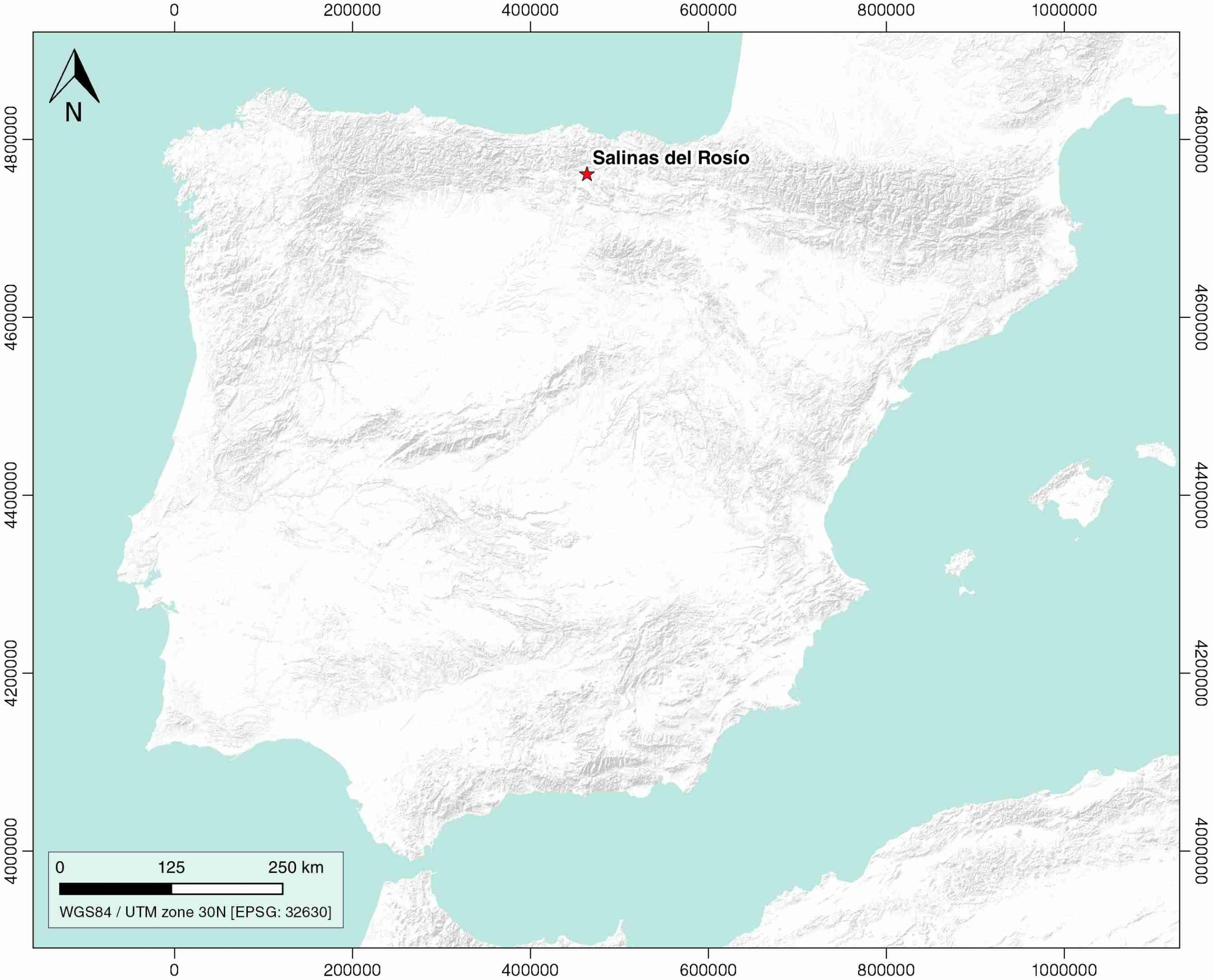
| Geological Setting | Basque-Cantabrian Basin, Navarra-Álava trough |
| Outcropping/buried | Outcropping |
| Evaporite unit/s name | Keuper facies |
| Evaporite unit/s age | Carnian-Rhaetian (Upper Triassic) |
| Evaporite unit/s origin | Marine |
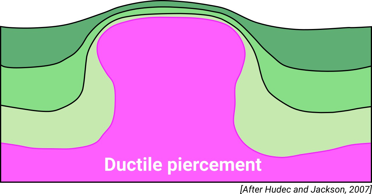
| Classif. (Hudec and Jackson, 2009) | Ductile piercement |
| Classif. (Jackson and Talbot, 1986) | Salt glacier, Salt pillow |
| Age of evaporite flow or deformation (when deformed) | Berriasian to Upper Miocene |
| Other comments | NW-SE orientation with a southern salt glacier |
Generic Data
| Unique ID | 18 |
| Name | Salinas del Rosio |
| Structure type | Evaporite diapir |
| Deformed/Undeformed | Deformed |
| Buried/Outcropping | Outcropping |
| Geological setting | Basque-Cantabrian Basin |
| Geological Regional Setting | Navarra-Álava trough |
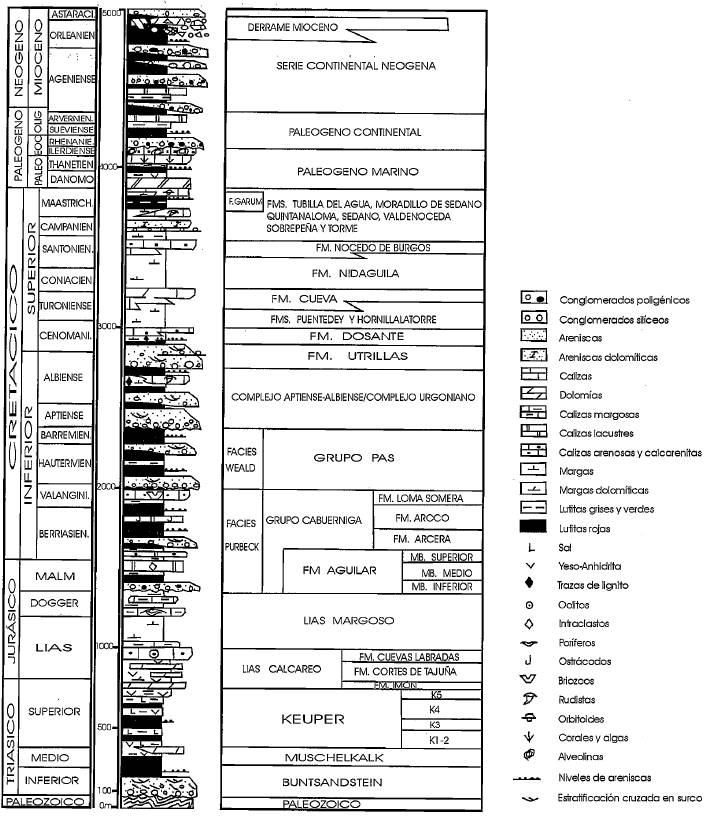
| Evaporite unit/s name | Keuper facies |
| Evaporite unit/s age | Carnian-Rhaetian (Upper Triassic) |
| Evaporite unit/s era | Mesozoic |
| Evaporite unit/s origin | Marine |
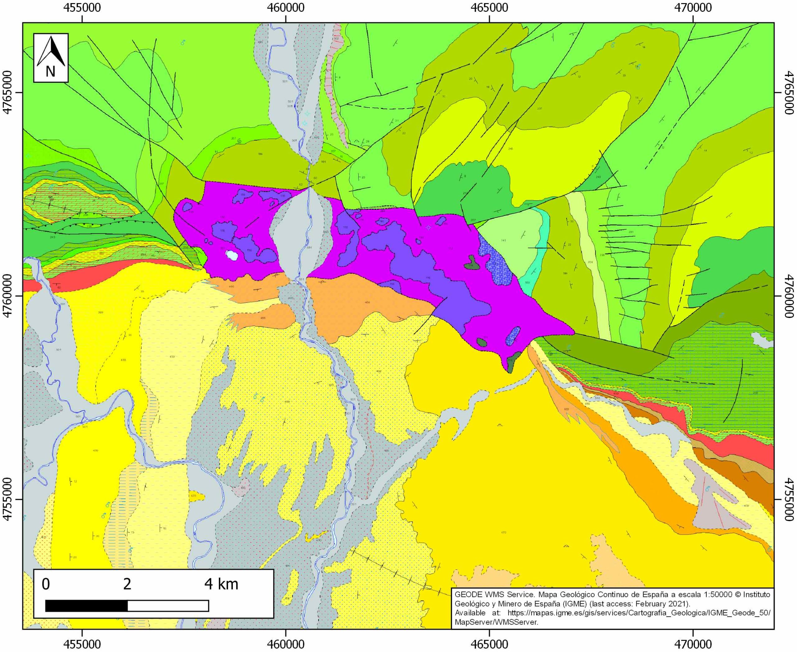
| Evaporite unit/s composition | Gypsum-Halite-Anhydrite-Claystone-Ophites |
| Post-kinematic unit/s (or post-evaporite units when evaporites are undeformed) | Quaternary (alluvial and colluvial detrital deposits) |
| Post-kinematic unit/s age (or post-evaporite units when evaporites are undeformed) | Holocene |
| Classification (Hudec and Jackson, 2009) | Ductile piercement |
| Classification (Jackson and Talbot, 1986) | Salt pillow |
| Mining activity? | Y |
| Mining activity start | Roman Empire |
| Mining activity end | 19th century |
| Mining galleries? | N |
| Mining products | Salt springs, Gem salt |
| Mining sub-products | |
| Evaporite flow? | Y |
| Age of evaporite flow | Berriasian – Upper Miocene |
| Flow or deformation triggering mechanisms | Mesozoic extensional regime in the Basque–Cantabrian Basin (early stage) and Alpine compression (late stage) |
| Flow-linked structures? | Y |
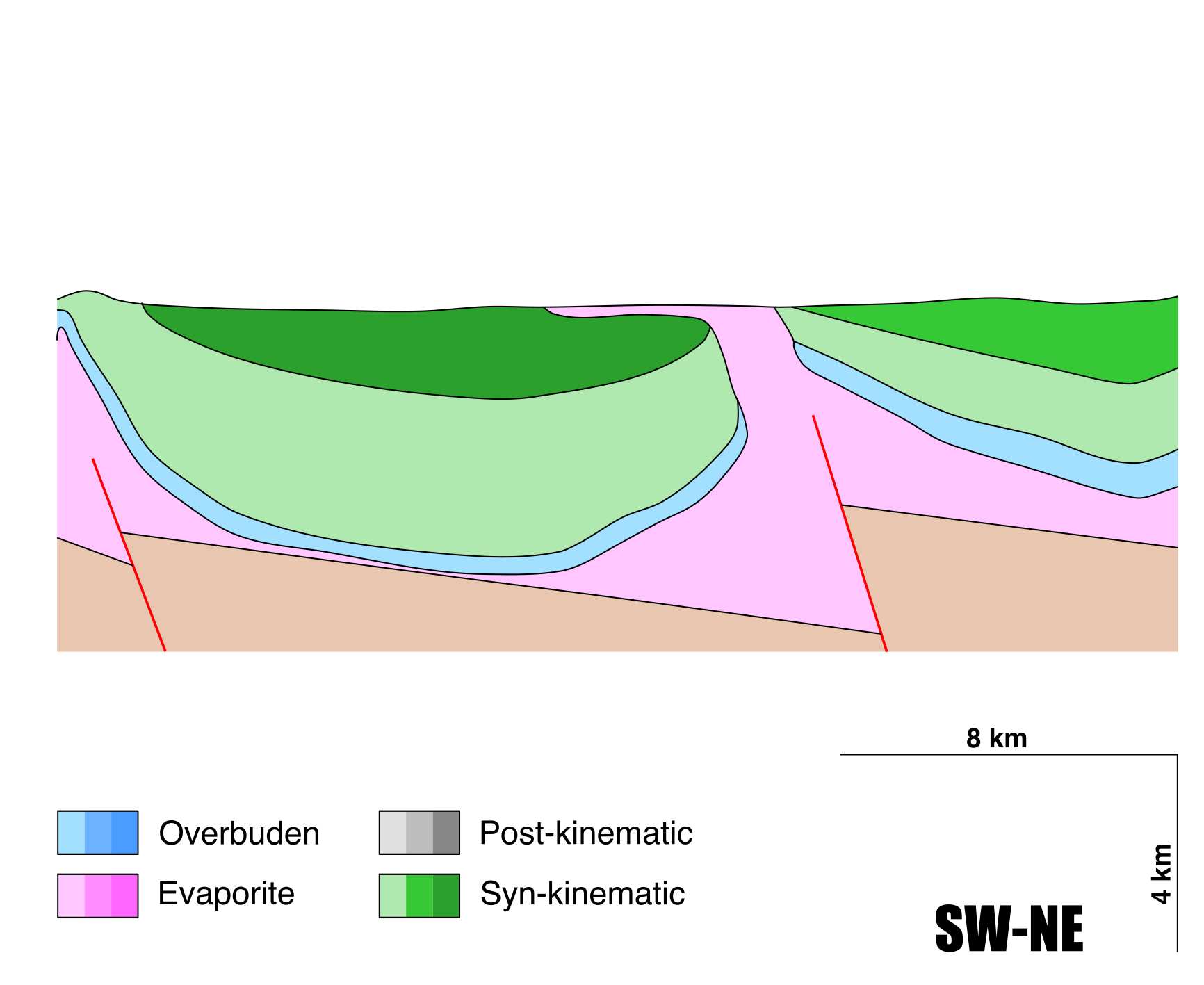
| Halokinetic structures | Syncline-Anticline folding / Normal Faults / Reverse faults / Progressive unconformities |
| Post-evaporite and pre-kinematic unit/s (overbuden) | Lower Jurassic (dolomitic brecchias, limestones and marls) |
| Syn-kinematic unit/s | Albo-Cenomanian (Valmaseda Fm.) / Cenomanian (marls and limestones) / Turonian (Gárate limestones Fm.) / Middle-Upper Turonian (Zuazo marls Fm.) / Lower Coniacian (Subijana limestones) / Palaeocene-Eocene (limestones, clays and marls) / Miocene (sandstones and conglomerates) |
| Available seismic profiles | PR-29 / P-7-1 / 1 / PR-30 / PR-51 / 44200 / PR-40 / PR-32-P / 44207 / 70 / PR-54 / 69 / PR-37 / PR-32 / 44204 / PR-49 / PR-56 / PR-40 / PR-32-P / PR-31 / PR-30 |
| Available boreholes | (Private Access): Retuerta-1 / Ribero-2 / Trespaderne-1 |
| Additional comments | Seismic profiles interpretations available at Poprawski, Y., Basile, C., 2018. Long-lasting diapir growth history in the Basque-Cantabrian basin (Northern Spain): a review. Conference poster, Advances in Salt Tectonics: Observations, Applications, and Perspective: In Honor of Martin P.A. Jackson. https://www.essoar.org/doi/abs/10.1002/essoar.10500041.1 |
Mining Data
| UNIQUE_ID | 18 |
| Minning exploitations within <2km? | Y |
| Historical/Active | Active |
| Exploitation name #1 | LA NORIA I |
| Exploitation ID (Spanish National Mining Cadastre) #1 | 3785 |
| Municipality #1 | Medina de Pomar |
| Province #1 | BURGOS |
| Company #1 | SALINERA LA NORIA, S.A. |
| Main minning Products #1 | Salt springs, Gem salt |
| Exploitation name #2 | |
| Exploitation ID (Spanish National Mining Cadastre) #2 | |
| Municipality #2 | |
| Province #2 | |
| Company #2 | |
| Main minning Products #2 | |
| Exploitation name #3 | |
| Exploitation ID (Spanish National Mining Cadastre) #3 | |
| Municipality #3 | |
| Province #3 | |
| Company #3 | |
| Main minning Products #3 |
Quantitative Data
| UNIQUE_ID | 18 |
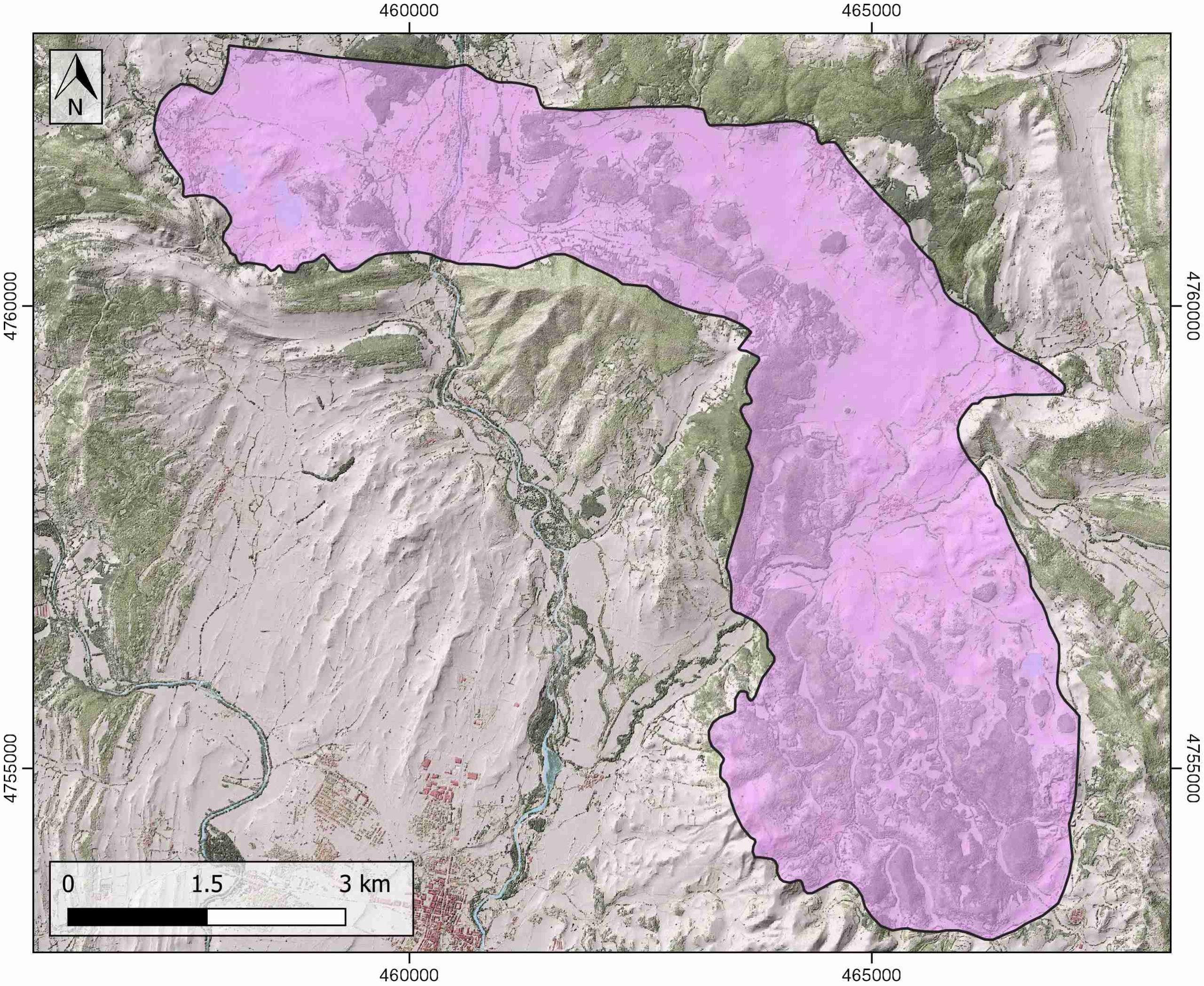
| Outcropping area (km2) | 36.135 |
| Horizontal intersection area (km2) (when buried) | Not buried |
| Depth of intersection area (km2) (when buried) | Not buried |
| Max. Width (Km) | 12.9 |
| Max. Length (Km) | 5.9 |
| Max. Evaporites thickness (km) | 5.5 |
| Max. Deformation age (Ma) | 129 |
| Min. Deformation age (Ma) | 11 |
| Deformation stages | 1 |
Reference Data
| UNIQUE_ID | 18 |
| Section source | Poprawski, Y., Basile, C., 2018. Long-lasting diapir growth history in the Basque-Cantabrian basin (Northern Spain): a review. Conference poster, Advances in Salt Tectonics: Observations, Applications, and Perspective: In Honor of Martin P.A. Jackson. [link] |
| Well / Borehole availability #1 | Hernaiz-Huerta, P.P., Pond, S., 2000. Las estructuras del diapiro de Salinas de Rosío y del Alto de San Pedro-Iglesias y sus implicaciones en la evolución tectónica de la transversal Burgalesa de la Cordillera Vascocantábrica-Cuenca del Duero. Revista de la Sociedad Geológica de España, 13, 3-4. [link] |
| Well / Borehole availability #2 | Poprawski, Y., Basile, C., 2018. Long-lasting diapir growth history in the Basque-Cantabrian basin (Northern Spain): a review. Conference poster, Advances in Salt Tectonics: Observations, Applications, and Perspective: In Honor of Martin P.A. Jackson. [link] |
| Available data (Stratigraphy) #1 | Hernaiz-Huerta, P.P., Pond, S., 2000. Las estructuras del diapiro de Salinas de Rosío y del Alto de San Pedro-Iglesias y sus implicaciones en la evolución tectónica de la transversal Burgalesa de la Cordillera Vascocantábrica-Cuenca del Duero. Revista de la Sociedad Geológica de España, 13, 3-4. [link] |
| Available data (Stratigraphy) #2 | Robles, S., 2014. Evolución geológica de la Cuenca Vasco-Cantábrica. Geología de la Cuenca Vasco-Cantábrica. Bilbao: Servicio editorial de la Universidad del País Vasco, 9-104. [link] |
| Available data (Stratigraphy) #3 | Serrano, A., Martínez del Olmo, W., 1990. Tectónica salina en el Dominio Cántabro-Navarro: evolución, edad y origen de las estructuras salinas Formaciones evaporíticas de la Cuenca del Ebro y cadenas periféricas, y de la zona de Levante: Empresa Nacional de Residuos Radioactivos Sociedad Anónima and Universitat de Barcelona, ENRESA-UB, 39-53. Unpublished. |
| Available data (Stratigraphy) #4 | Nettleton, L.L., 1968. Gravity anomalies over salt diapirs, northern Spain. Geological Society of America Special Papers, 88, 75–82. [link] |
| Available data (Stratigraphy) #5 | Bodego, A., Iriarte, E., López-Horgue, M. A., Álvarez, I., 2018. Rift-margin extensional forced folds and salt tectonics in the eastern Basque-Cantabrian rift basin (western Pyrenees). Marine and Petroleum Geology, 91, 667-682. [link] |
| Available data (Stratigraphy) #6 | n.a. |
| Regional Stratigraphy | Hernaiz-Huerta, P.P., Pond, S., 2000. Las estructuras del diapiro de Salinas de Rosío y del Alto de San Pedro-Iglesias y sus implicaciones en la evolución tectónica de la transversal Burgalesa de la Cordillera Vascocantábrica-Cuenca del Duero. Revista de la Sociedad Geológica de España, 13, 3-4. [link] |
| Seismic data availability #1 | Poprawski, Y., Basile, C., 2018. Long-lasting diapir growth history in the Basque-Cantabrian basin (Northern Spain): a review. Conference poster, Advances in Salt Tectonics: Observations, Applications, and Perspective: In Honor of Martin P.A. Jackson. [link] |
| Seismic data availability #2 | Serrano, A., Martínez del Olmo, W., 1990. Tectónica salina en el Dominio Cántabro-Navarro: evolución, edad y origen de las estructuras salinas Formaciones evaporíticas de la Cuenca del Ebro y cadenas periféricas, y de la zona de Levante: Empresa Nacional de Residuos Radioactivos Sociedad Anónima and Universitat de Barcelona, ENRESA-UB, 39-53. Unpublished. |
| Seismic data availability #3 | Hernaiz-Huerta, P.P., Pond, S., 2000. Las estructuras del diapiro de Salinas de Rosío y del Alto de San Pedro-Iglesias y sus implicaciones en la evolución tectónica de la transversal Burgalesa de la Cordillera Vascocantábrica-Cuenca del Duero. Revista de la Sociedad Geológica de España, 13, 3-4. [link] |
| Available data (Structure) #1 | Hernaiz-Huerta, P.P., Pond, S., 2000. Las estructuras del diapiro de Salinas de Rosío y del Alto de San Pedro-Iglesias y sus implicaciones en la evolución tectónica de la transversal Burgalesa de la Cordillera Vascocantábrica-Cuenca del Duero. Revista de la Sociedad Geológica de España, 13, 3-4. [link] |
| Available data (Structure) #2 | Poprawski, Y., Basile, C., 2018. Long-lasting diapir growth history in the Basque-Cantabrian basin (Northern Spain): a review. Conference poster, Advances in Salt Tectonics: Observations, Applications, and Perspective: In Honor of Martin P.A. Jackson. [link] |
| Available data (Structure) #3 | Serrano, A., Martínez del Olmo, W., 1990. Tectónica salina en el Dominio Cántabro-Navarro: evolución, edad y origen de las estructuras salinas Formaciones evaporíticas de la Cuenca del Ebro y cadenas periféricas, y de la zona de Levante: Empresa Nacional de Residuos Radioactivos Sociedad Anónima and Universitat de Barcelona, ENRESA-UB, 39-53. Unpublished. |
| Available data (Structure) #4 | Ábalos, B., 2016. Geologic map of the Basque-Cantabrian Basin and a new tectonic interpretation of the Basque Arc. International Journal of Earth Sciences, 105, 2327-2354. [link] |
| Available data (Structure) #5 | Pedrera, A., García‐Senz, J., Ayala, C., Ruiz‐Constán, A., Rodríguez‐Fernández, L. R., Robador, A., González Menéndez, L., 2017. Reconstruction of the exhumed mantle across the North Iberian Margin by crustal‐scale 3‐D gravity inversion and geological cross section. Tectonics, 36, 3155-3177. [link] |
| Available data (Structure) #6 | n.a. |
| Available data (Analogue modelling) #1 | n.a. |
| Available data (Analogue modelling) #2 | n.a. |
| Available data (Analogue modelling) #3 | n.a. |
| Available data (Gravimetry – Tomography) #1 | Pedrera, A., García‐Senz, J., Ayala, C., Ruiz‐Constán, A., Rodríguez‐Fernández, L. R., Robador, A., González Menéndez, L., 2017. Reconstruction of the exhumed mantle across the North Iberian Margin by crustal‐scale 3‐D gravity inversion and geological cross section. Tectonics, 36, 3155-3177. [link] |
| Available data (Gravimetry – Tomography) #2 | Nettleton, L.L., 1968. Gravity anomalies over salt diapirs, northern Spain. Geological Society of America Special Papers, 88, 75–82. [link] |
| Available data (Gravimetry – Tomography) #3 | Pinto, V., Casas, A., Rivero, L., Torne, M., 2005. 3D gravity modeling of the Triassic salt diapirs of the Cubeta Alavesa (northern Spain). Tectonophysics, 405, 65-75. [link] |
| Available data (Geochemistry) #1 | Ortí, F., García-Veigas, J., Rossell, L., Jurado, M. J., Utrilla, R., 1996. Formaciones salinas de las cuencas triásicas en la Península Ibérica: Caracterización Petrológica y Geoquímica. Cuadernos de Geología Ibérica, 20, 13-35. [link] |
| Available data (Geochemistry) #2 | Iribar, V., Ábalos, B. 2011. The geochemical and isotopic record of evaporite recycling in spas and salterns of the Basque Cantabrian basin, Spain. Applied geochemistry, 26, 1315-1329. [link] |
| Available data (Geochemistry) #3 | Reitner, J., 1986. A comparative study of the diagenesis in diapir-influenced reef atolls and a fault block reef platform in the Late Albian of the Vasco-Cantabrian Basin (Northern Spain). In Reef diagenesis (pp. 186-209). Springer, Berlin, Heidelberg. [link] |
| Available data (Geochemistry) #4 | n.a. |
| Available data (Petrophysics) #1 | Llamas, B., Castañeda, M. C., Laín, C., Pous, J., 2017. Study of the Basque–Cantabrian basin as a suitable region for the implementation of an energy storage system based on compressed air energy storage (CAES). Environmental Earth Sciences, 76(5), 204. [link] |
| Available data (Petrophysics) #2 | n.a. |
| IGME Geological Map (MAGNA50) Sheet number | 85-Villasana de Mena. [link] / 110-Medina del Pomar. [link] |
| Other Maps #1 (source) | Perona, J., 2016. Mineralizaciones de Pb-Zn asociadas a los diapiros de Murguía y Orduña (Cuenca Vasco-Cantábrica) [PhD thesis]: Barcelona, Universitat de Barcelona, 281 pp. [link] |
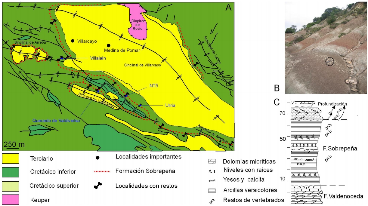
| Other Maps #2 (source) | Berreteaga, A., Pereda-Suberbiola, X., Floquet, M., Olivares, M., Etxebarria, N., Iriarte, E., …, Astibia, H., 2008. Datos sedimentológicos y tafonómicos de enclaves finicretácicos con fósiles de vertebrados de la Formación Sobrepeña (Burgos, Región Vasco-Cantábrica): Geo. Temas, 10, 1277-1280. [link] |
| Other related references #1 | Cámara, P., 2017. Salt and Strike-Slip Tectonics as Main Drivers in the Structural Evolution of the Basque-Cantabrian Basin, Spain. In Permo-Triassic Salt Provinces of Europe, North Africa and the Atlantic Margins (pp. 371-393). Elsevier. [link] |
| Other related references #2 | Taviani, S., Muñoz, J.A., 2012. Mesozoic rifting in the Basque-Cantabrian basin (Spain): Inherited faults, transversal structures, and stress perturbation. Terra Nova, 24, 70–76. [link] |
| Other related references #3 | López-Horgue, M.A., Hernández, J.M., 2003. La cuenca terciaria continental del Diapiro de Murguía: la Formación Izarra (Oligoceno superior-Mioceno inferior, Cuenca Vasco-Cantábrica). Geogaceta, 33, 123–126. [link] |
| Other related references #4 | Cámara, P., 2020. Inverted turtle salt anticlines in the eastern basque-cantabrian basin, Spain. Marine and Petroleum Geology, 104358. [link] |
Well and Seismic Data
| UNIQUE_ID | 18 |
| Seismic survey name #1 | 7C1-PR |
| Across structure? #1 | Y |
| Seismic profile ID (IGME) #1 | 9452 |
| Seismic profile code #1 | 14025 |
| Seismic profile name #1 | PR-29 |
| Seismic survey year #1 | 1978 |
| Data repository #1 | SIGEOF Data Catalogue (Section available under request). ©Instituto Geológico y Minero de España (IGME). https://info.igme.es/SIGEOF/ |
| Length (km) #1 | 14.87 |
| Seismic survey name #2 | 7C-ST-98-98BIS |
| Across structure? #2 | Y |
| Seismic profile ID (IGME) #2 | 12861 |
| Seismic profile code #2 | 17579 |
| Seismic profile name #2 | P-7-1 |
| Seismic survey year #2 | 1964 |
| Data repository #2 | SIGEOF Data Catalogue (Private access section). ©Instituto Geológico y Minero de España (IGME). https://info.igme.es/SIGEOF/ |
| Length (km) #2 | 12.01 |
| Seismic survey name #3 | 7C-ST-98-98BIS |
| Across structure? #3 | Y |
| Seismic profile ID (IGME) #3 | 12937 |
| Seismic profile code #3 | 17655 |
| Seismic profile name #3 | 1 |
| Seismic survey year #3 | 1961 |
| Data repository #3 | SIGEOF Data Catalogue (Private access section). ©Instituto Geológico y Minero de España (IGME). https://info.igme.es/SIGEOF/ |
| Length (km) #3 | 13.16 |
| Seismic survey name #4 | 7C1-PR |
| Across structure? #4 | Y |
| Seismic profile ID (IGME) #4 | 9451 |
| Seismic profile code #4 | 14024 |
| Seismic profile name #4 | PR-30 |
| Seismic survey year #4 | 1978 |
| Data repository #4 | SIGEOF Data Catalogue (Section available under request). ©Instituto Geológico y Minero de España (IGME). https://info.igme.es/SIGEOF/ |
| Length (km) #4 | 15.48 |
| Seismic survey name #5 | 7C1-PR |
| Across structure? #5 | Y |
| Seismic profile ID (IGME) #5 | 9439 |
| Seismic profile code #5 | 14012 |
| Seismic profile name #5 | PR-51 |
| Seismic survey year #5 | 1978 |
| Data repository #5 | SIGEOF Data Catalogue (Section available under request). ©Instituto Geológico y Minero de España (IGME). https://info.igme.es/SIGEOF/ |
| Length (km) #5 | 31.40 |
| Seismic survey name #6 | 7C-ST-98-98BIS |
| Across structure? #6 | Y |
| Seismic profile ID (IGME) #6 | 12902 |
| Seismic profile code #6 | 17620 |
| Seismic profile name #6 | 44200 |
| Seismic survey year #6 | 1961 |
| Data repository #6 | SIGEOF Data Catalogue (Private access section). ©Instituto Geológico y Minero de España (IGME). https://info.igme.es/SIGEOF/ |
| Length (km) #6 | 5.81 |
| Seismic survey name #7 | 7C1-PR |
| Across structure? #7 | Y |
| Seismic profile ID (IGME) #7 | 9444 |
| Seismic profile code #7 | 14017 |
| Seismic profile name #7 | PR-40 |
| Seismic survey year #7 | 1978 |
| Data repository #7 | SIGEOF Data Catalogue (Section available under request). ©Instituto Geológico y Minero de España (IGME). https://info.igme.es/SIGEOF/ |
| Length (km) #7 | 15.49 |
| Seismic survey name #8 | 7C1-PR |
| Across structure? #8 | Y |
| Seismic profile ID (IGME) #8 | 9448 |
| Seismic profile code #8 | 14021 |
| Seismic profile name #8 | PR-32-P |
| Seismic survey year #8 | 1978 |
| Data repository #8 | SIGEOF Data Catalogue (Section available under request). ©Instituto Geológico y Minero de España (IGME). https://info.igme.es/SIGEOF/ |
| Length (km) #8 | 16.03 |
| Seismic survey name #9 | 7C-ST-98-98BIS |
| Across structure? #9 | Y |
| Seismic profile ID (IGME) #9 | 12931 |
| Seismic profile code #9 | 17649 |
| Seismic profile name #9 | 44207 |
| Seismic survey year #9 | 1961 |
| Data repository #9 | SIGEOF Data Catalogue (Private access section). ©Instituto Geológico y Minero de España (IGME). https://info.igme.es/SIGEOF/ |
| Length (km) #9 | 5.25 |
| Seismic survey name #10 | 7C-ST-98-98BIS |
| Across structure? #10 | Y |
| Seismic profile ID (IGME) #10 | 12887 |
| Seismic profile code #10 | 17605 |
| Seismic profile name #10 | 70 |
| Seismic survey year #10 | 1961 |
| Data repository #10 | SIGEOF Data Catalogue (Private access section). ©Instituto Geológico y Minero de España (IGME). https://info.igme.es/SIGEOF/ |
| Length (km) #10 | 4.71 |
| Seismic survey name #11 | 7C1-PR |
| Across structure? #11 | Y |
| Seismic profile ID (IGME) #11 | 9436 |
| Seismic profile code #11 | 14009 |
| Seismic profile name #11 | PR-54 |
| Seismic survey year #11 | 1978 |
| Data repository #11 | SIGEOF Data Catalogue (Section available under request). ©Instituto Geológico y Minero de España (IGME). https://info.igme.es/SIGEOF/ |
| Length (km) #11 | 12.27 |
| Seismic survey name #12 | 7C-ST-98-98BIS |
| Across structure? #12 | Y |
| Seismic profile ID (IGME) #12 | 12889 |
| Seismic profile code #12 | 17607 |
| Seismic profile name #12 | 69 |
| Seismic survey year #12 | 1961 |
| Data repository #12 | SIGEOF Data Catalogue (Private access section). ©Instituto Geológico y Minero de España (IGME). https://info.igme.es/SIGEOF/ |
| Length (km) #12 | 8.07 |
| Seismic survey name #13 | 7C1-PR |
| Across structure? #13 | Y |
| Seismic profile ID (IGME) #13 | 9445 |
| Seismic profile code #13 | 14018 |
| Seismic profile name #13 | PR-37 |
| Seismic survey year #13 | 1978 |
| Data repository #13 | SIGEOF Data Catalogue (Section available under request). ©Instituto Geológico y Minero de España (IGME). https://info.igme.es/SIGEOF/ |
| Length (km) #13 | 18.36 |
| Seismic survey name #14 | 7C1-PR |
| Across structure? #14 | Y |
| Seismic profile ID (IGME) #14 | 9449 |
| Seismic profile code #14 | 14022 |
| Seismic profile name #14 | PR-32 |
| Seismic survey year #14 | 1978 |
| Data repository #14 | SIGEOF Data Catalogue (Section available under request). ©Instituto Geológico y Minero de España (IGME). https://info.igme.es/SIGEOF/ |
| Length (km) #14 | 13.08 |
| Seismic survey name #15 | 7C-ST-98-98BIS |
| Across structure? #15 | Y |
| Seismic profile ID (IGME) #15 | 12878 |
| Seismic profile code #15 | 17596 |
| Seismic profile name #15 | 44204 |
| Seismic survey year #15 | 1961 |
| Data repository #15 | SIGEOF Data Catalogue (Private access section). ©Instituto Geológico y Minero de España (IGME). https://info.igme.es/SIGEOF/ |
| Length (km) #15 | 6.21 |
| Seismic survey name #16 | 7C1-PR |
| Across structure? #16 | Y |
| Seismic profile ID (IGME) #16 | 9440 |
| Seismic profile code #16 | 14013 |
| Seismic profile name #16 | PR-49 |
| Seismic survey year #16 | 1976 |
| Data repository #16 | SIGEOF Data Catalogue (Section available under request). ©Instituto Geológico y Minero de España (IGME). https://info.igme.es/SIGEOF/ |
| Length (km) #16 | 29.14 |
| Seismic survey name #17 | 7C1-PR |
| Across structure? #17 | N (within 3km) |
| Seismic profile ID (IGME) #17 | 9434 |
| Seismic profile code #17 | 14007 |
| Seismic profile name #17 | PR-56 |
| Seismic survey year #17 | 1978 |
| Data repository #17 | SIGEOF Data Catalogue (Section available under request). ©Instituto Geológico y Minero de España (IGME). https://info.igme.es/SIGEOF/ |
| Length (km) #17 | 9.29 |
| Seismic survey name #18 | 7C1-PR |
| Across structure? #18 | N (within 3km) |
| Seismic profile ID (IGME) #18 | 9444 |
| Seismic profile code #18 | 14017 |
| Seismic profile name #18 | PR-40 |
| Seismic survey year #18 | 1978 |
| Data repository #18 | SIGEOF Data Catalogue (Section available under request). ©Instituto Geológico y Minero de España (IGME). https://info.igme.es/SIGEOF/ |
| Length (km) #18 | 15.49 |
| Seismic survey name #19 | 7C1-PR |
| Across structure? #19 | N (within 3km) |
| Seismic profile ID (IGME) #19 | 9448 |
| Seismic profile code #19 | 14021 |
| Seismic profile name #19 | PR-32-P |
| Seismic survey year #19 | 1978 |
| Data repository #19 | SIGEOF Data Catalogue (Section available under request). ©Instituto Geológico y Minero de España (IGME). https://info.igme.es/SIGEOF/ |
| Length (km) #19 | 16.03 |
| Seismic survey name #20 | 7C1-PR |
| Across structure? #20 | N (within 3km) |
| Seismic profile ID (IGME) #20 | 9450 |
| Seismic profile code #20 | 14023 |
| Seismic profile name #20 | PR-31 |
| Seismic survey year #20 | 1978 |
| Data repository #20 | SIGEOF Data Catalogue (Section available under request). ©Instituto Geológico y Minero de España (IGME). https://info.igme.es/SIGEOF/ |
| Length (km) #20 | 17.34 |
| Seismic survey name #21 | 7C1-PR |
| Across structure? #21 | N (within 3km) |
| Seismic profile ID (IGME) #21 | 9451 |
| Seismic profile code #21 | 14024 |
| Seismic profile name #21 | PR-30 |
| Seismic survey year #21 | 1978 |
| Data repository #21 | SIGEOF Data Catalogue (Section available under request). ©Instituto Geológico y Minero de España (IGME). https://info.igme.es/SIGEOF/ |
| Length (km) #21 | 15.48 |
| Borehole name #1 | |
| Company #1 | |
| Traget #1 | |
| Across structure? #1 | |
| Borehole name #2 | |
| Company #2 | |
| Traget #2 | |
| Across structure? #2 | |
| Borehole name #3 | |
| Company #3 | |
| Traget #3 | |
| Across structure? #3 | |
| Borehole name #4 | |
| Company #4 | |
| Traget #4 | |
| Across structure? #4 | |
| Borehole name #5 | |
| Company #5 | |
| Traget #5 | |
| Across structure? #5 | |
| Borehole name #6 | |
| Company #6 | |
| Traget #6 | |
| Across structure? #6 | |
| Borehole name #7 | |
| Company #7 | |
| Traget #7 | |
| Across structure? #7 | |
| Borehole name #8 | |
| Company #8 | |
| Traget #8 | |
| Across structure? #8 | |
| Borehole name #9 | |
| Company #9 | |
| Traget #9 | |
| Across structure? #9 | |
| Borehole name #10 | |
| Company #10 | |
| Traget #10 | |
| Across structure? #10 | |
| Borehole name #11 | |
| Company #11 | |
| Traget #11 | |
| Across structure? #11 | |
| Borehole name #12 | |
| Company #12 | |
| Traget #12 | |
| Across structure? #12 | |
| Borehole name #13 | |
| Company #13 | |
| Traget #13 | |
| Across structure? #13 | |
| Borehole name #14 | |
| Company #14 | |
| Traget #14 | |
| Across structure? #14 | |
| Borehole name #15 | |
| Company #15 | |
| Traget #15 | |
| Across structure? #15 |
Geographical Data (EPSG:4326 - WGS 84)
| UNIQUE_ID | 18 |
| X Centroid (Structure shape) | -3.446753 |
| Y Centroid (Structure shape) | -3.446753 |
| Xmin (Structure shape) | -3.524745 |
| Xmax (Structure shape) | -3.401525 |
| Ymin (Structure shape) | 42.930181 |
| Ymax (Structure shape) | 43.016876 |
| Xmin seismic line #1 | -3.593218 |
| Xmax seismic line #1 | -3.425850 |
| Ymin seismic line #1 | 42.939295 |
| Ymax seismic line #1 | 42.991745 |
| Xmin seismic line #2 | -3.468974 |
| Xmax seismic line #2 | -3.343001 |
| Ymin seismic line #2 | 42.909397 |
| Ymax seismic line #2 | 42.956147 |
| Xmin seismic line #3 | -3.487762 |
| Xmax seismic line #3 | -3.469100 |
| Ymin seismic line #3 | 42.932074 |
| Ymax seismic line #3 | 43.045569 |
| Xmin seismic line #4 | -3.549082 |
| Xmax seismic line #4 | -3.477163 |
| Ymin seismic line #4 | 42.881337 |
| Ymax seismic line #4 | 43.010170 |
| Xmin seismic line #5 | -3.491191 |
| Xmax seismic line #5 | -3.179311 |
| Ymin seismic line #5 | 42.881260 |
| Ymax seismic line #5 | 43.035190 |
| Xmin seismic line #6 | -3.471580 |
| Xmax seismic line #6 | -3.415091 |
| Ymin seismic line #6 | 42.948058 |
| Ymax seismic line #6 | 42.976382 |
| Xmin seismic line #7 | -3.463477 |
| Xmax seismic line #7 | -3.375061 |
| Ymin seismic line #7 | 42.855446 |
| Ymax seismic line #7 | 42.978483 |
| Xmin seismic line #8 | -3.441599 |
| Xmax seismic line #8 | -3.357385 |
| Ymin seismic line #8 | 42.982262 |
| Ymax seismic line #8 | 43.111993 |
| Xmin seismic line #9 | -3.521813 |
| Xmax seismic line #9 | -3.515024 |
| Ymin seismic line #9 | 43.007827 |
| Ymax seismic line #9 | 43.054704 |
| Xmin seismic line #10 | -3.515515 |
| Xmax seismic line #10 | -3.488373 |
| Ymin seismic line #10 | 43.007852 |
| Ymax seismic line #10 | 43.045216 |
| Xmin seismic line #11 | -3.465605 |
| Xmax seismic line #11 | -3.409253 |
| Ymin seismic line #11 | 42.998953 |
| Ymax seismic line #11 | 43.100672 |
| Xmin seismic line #12 | -3.577258 |
| Xmax seismic line #12 | -3.485964 |
| Ymin seismic line #12 | 43.002677 |
| Ymax seismic line #12 | 43.027270 |
| Xmin seismic line #13 | -3.500166 |
| Xmax seismic line #13 | -3.456539 |
| Ymin seismic line #13 | 42.971576 |
| Ymax seismic line #13 | 43.129288 |
| Xmin seismic line #14 | -3.503587 |
| Xmax seismic line #14 | -3.436874 |
| Ymin seismic line #14 | 42.883878 |
| Ymax seismic line #14 | 42.990529 |
| Xmin seismic line #15 | -3.431795 |
| Xmax seismic line #15 | -3.367259 |
| Ymin seismic line #15 | 42.942839 |
| Ymax seismic line #15 | 42.967621 |
| Xmin seismic line #16 | -3.478357 |
| Xmax seismic line #16 | -3.213202 |
| Ymin seismic line #16 | 42.790428 |
| Ymax seismic line #16 | 42.958233 |
| Xmin seismic line #17 | -3.518564 |
| Xmax seismic line #17 | -3.493740 |
| Ymin seismic line #17 | 43.026545 |
| Ymax seismic line #17 | 43.106831 |
| Xmin seismic line #18 | -3.463477 |
| Xmax seismic line #18 | -3.375061 |
| Ymin seismic line #18 | 42.855446 |
| Ymax seismic line #18 | 42.978483 |
| Xmin seismic line #19 | -3.441599 |
| Xmax seismic line #19 | -3.357385 |
| Ymin seismic line #19 | 42.982262 |
| Ymax seismic line #19 | 43.111993 |
| Xmin seismic line #20 | -3.542882 |
| Xmax seismic line #20 | -3.387540 |
| Ymin seismic line #20 | 42.855602 |
| Ymax seismic line #20 | 42.949454 |
| Xmin seismic line #21 | -3.549082 |
| Xmax seismic line #21 | -3.477163 |
| Ymin seismic line #21 | 42.881337 |
| Ymax seismic line #21 | 43.010170 |
| X borehole #1 | |
| Y borehole #1 | |
| X borehole #2 | |
| Y borehole #2 | |
| X borehole #3 | |
| Y borehole #3 | |
| X borehole #4 | |
| Y borehole #4 | |
| X borehole #5 | |
| Y borehole #5 | |
| X borehole #6 | |
| Y borehole #6 | |
| X borehole #7 | |
| Y borehole #7 | |
| X borehole #8 | |
| Y borehole #8 | |
| X borehole #9 | |
| Y borehole #9 | |
| X borehole #10 | |
| Y borehole #10 | |
| X borehole #11 | |
| Y borehole #11 | |
| X borehole #12 | |
| Y borehole #12 | |
| X borehole #13 | |
| Y borehole #13 | |
| X borehole #14 | |
| Y borehole #14 | |
| X borehole #15 | |
| Y borehole #15 |

