Serres de Llevant
ID #133
General Information
| Structure type | Evaporite-detached thrust |
| Deformed/Undeformed | Deformed |
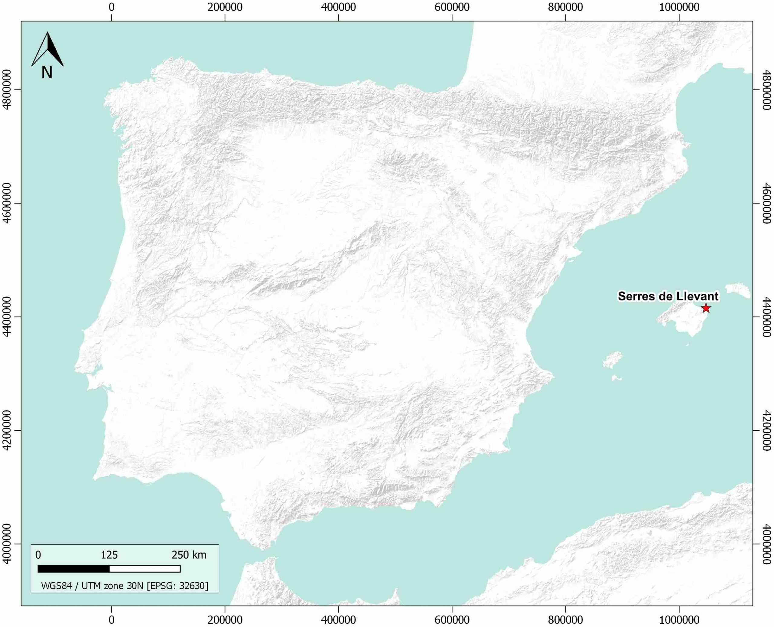
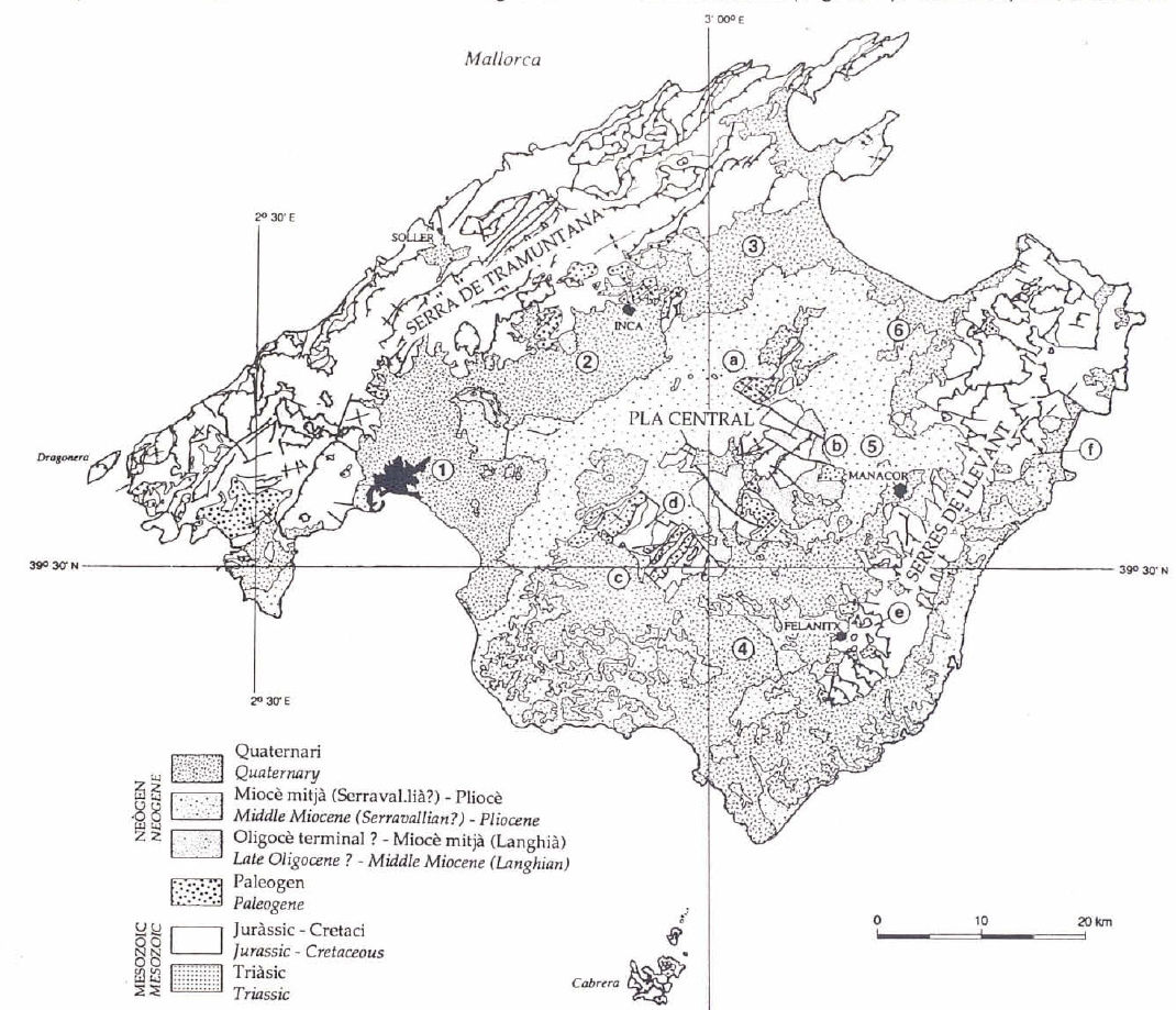
| Geological Setting | Betic system, Serres de Llevant range (Mallorca island) |
| Outcropping/buried | Outcropping |
| Evaporite unit/s name | Keuper facies, Middle Muschelkalk facies |
| Evaporite unit/s age | Upper Anisian and Carnian-Rhaetian (Middle-Upper Triassic) |
| Evaporite unit/s origin | Marine |
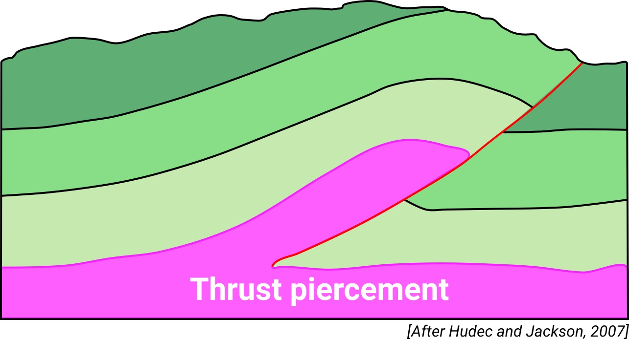
| Classif. (Hudec and Jackson, 2009) | Thrust piercement |
| Classif. (Jackson and Talbot, 1986) | |
| Age of evaporite flow or deformation (when deformed) | Oligocene to Miocene |
| Other comments | The Serres de Llevant and the Serra de Tramuntana at the north-western part of the island, are considered to be the north-eastern end of the Betic fold-and-thrust belt. |
Generic Data
| Unique ID | 133 |
| Name | Serres de Llevant |
| Structure type | Evaporite-detached thrust |
| Deformed/Undeformed | Deformed |
| Buried/Outcropping | Outcropping |
| Geological setting | Betic System |
| Geological Regional Setting | Serres de Llevant range (Mallorca island) |
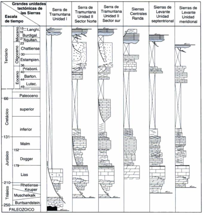
| Evaporite unit/s name | Middle Muschelkalk and Keuper Facies |
| Evaporite unit/s age | Upper Anisian and Carnian-Rhaetian (Middle-Upper Triassic) |
| Evaporite unit/s era | Mesozoic |
| Evaporite unit/s origin | Marine |
| Evaporite unit/s composition | Claystonestone-Gypsum-Sandstone-Volcanic rocks |
| Post-kinematic unit/s (or post-evaporite units when evaporites are undeformed) | Middle Miocene (conglomerates and sandstones) ; Upper Miocene (limestones) ; Pliocene (calcarenites) ; Quaternary (alluvial and colluvial detrital deposits) |
| Post-kinematic unit/s age (or post-evaporite units when evaporites are undeformed) | Middle Miocene-Holocene |
| Classification (Hudec and Jackson, 2009) | Thrust piercement |
| Classification (Jackson and Talbot, 1986) | |
| Mining activity? | N |
| Mining activity start | |
| Mining activity end | |
| Mining galleries? | |
| Mining products | |
| Mining sub-products | |
| Evaporite flow? | Y |
| Age of evaporite flow | Oligocene-Lower Miocene |
| Flow or deformation triggering mechanisms | Alpine compression |
| Flow-linked structures? | Y |
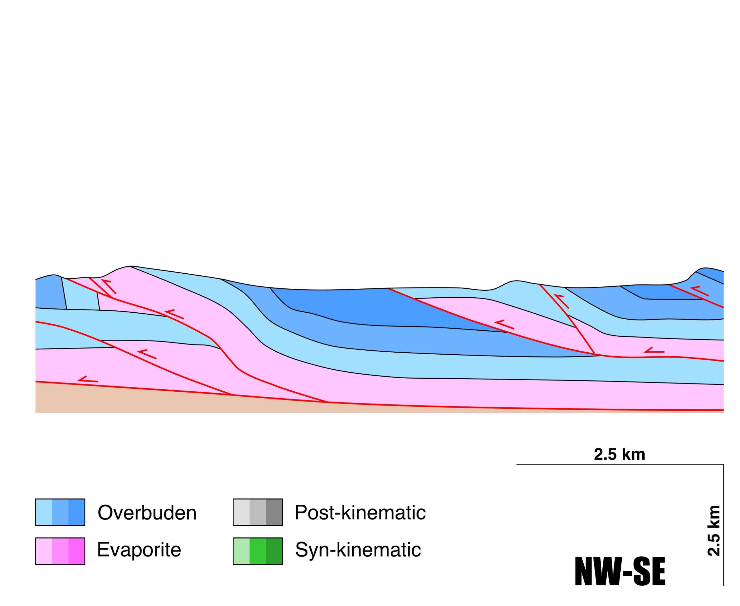
| Halokinetic structures | Thrust faults / anticline-syncline folding |
| Post-evaporite and pre-kinematic unit/s (overbuden) | Upper Triassic (Rhaetian, dolostones, brecchias and «carniolas») ; Lower Jurassic (tabular limestones and dolostones) ; Middle Jurassic (marlstones, marly limestones and limestones) ; Upper Jurassic (oolitic limestones and tabular limestones) ; Lower Cretaceous (sandy limestones and marlstones, marly limestones) ; Eocene (conglomerates, sandstones and claystones) |
| Syn-kinematic unit/s | Early Miocene (conglomerates, sandstones and claystones with a uppermost marlstone level) |
| Available seismic profiles | |
| Available boreholes | |
| Additional comments | The Serres de Llevant and the Serra de Tramuntana at the north-western part of the island, are considered to be the north-eastern end of the Betic fold-and-thrust belt |
Mining Data
| UNIQUE_ID | 133 |
| Minning exploitations within <2km? | N |
| Historical/Active | |
| Exploitation name #1 | |
| Exploitation ID (Spanish National Mining Cadastre) #1 | |
| Municipality #1 | |
| Province #1 | |
| Company #1 | |
| Main minning Products #1 | |
| Exploitation name #2 | |
| Exploitation ID (Spanish National Mining Cadastre) #2 | |
| Municipality #2 | |
| Province #2 | |
| Company #2 | |
| Main minning Products #2 | |
| Exploitation name #3 | |
| Exploitation ID (Spanish National Mining Cadastre) #3 | |
| Municipality #3 | |
| Province #3 | |
| Company #3 | |
| Main minning Products #3 |
Quantitative Data
| UNIQUE_ID | 133 |
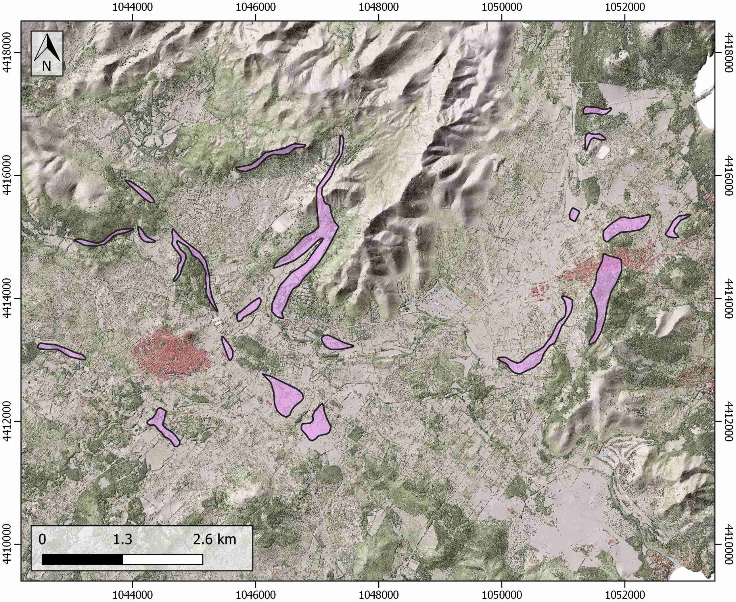
| Outcropping area (km2) | 2.53504 |
| Horizontal intersection area (km2) (when buried) | Not buried |
| Depth of intersection area (km2) (when buried) | Not buried |
| Max. Width (Km) | 4.85014247 |
| Max. Length (Km) | 10.7994371 |
| Max. Evaporites thickness (km) | 0.3 |
| Max. Deformation age (Ma) | 30 |
| Min. Deformation age (Ma) | 14 |
| Deformation stages | 1 |
Reference Data
| UNIQUE_ID | 133 |
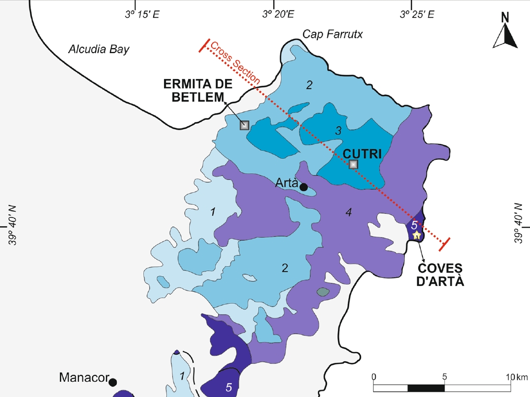
| Section source | Sàbat, F., Gelabert, B., Rodríguez-Perea, A., Giménez, J., 2011. Geological structure and evolution of Majorca: Implications for the origin of the Western Mediterranean. Tectonophysics, 510(1-2), 217-238. [link] |
| Well / Borehole availability #1 | n.a. |
| Well / Borehole availability #2 | n.a. |
| Available data (Stratigraphy) #1 | Rosales, I., Barnolas, A., López-García, J. M., Sevillano, A., 2021. Strontium isotope stratigraphy (SIS) dating of the Bathonian regression in western Tethys (Mallorca island). Journal of Iberian Geology, 1-18. [link] |
| Available data (Stratigraphy) #2 | Sàbat, F., Muñoz, J., Santanach, P., 1988. Transversal and oblique structures at the Serres de Llevant thrust belt (Mallorca Island). Geologische Rundschau, 77(2), 529-538. [link] |
| Available data (Stratigraphy) #3 | Morey, B., 2018. El registro Messiniense de la isla de Mallorca (archipiélago Balear, Mediterráneo occidental). Revisión e interpretación. Estudios Geológicos, 74(2), e083. [link] |
| Available data (Stratigraphy) #4 | Rodríguez-Perea, A., Ramos-Guerrero, E., Pomar, L., Paniello, X., Obrador, A., Martí, J., 1987. El Triásico de las Baleares. Cuadernos de Geología Ibérica, 11, 295-321. [link] |
| Available data (Stratigraphy) #5 | Sàbat, F., Gelabert, B., Rodríguez-Perea, A., Giménez, J., 2011. Geological structure and evolution of Majorca: Implications for the origin of the Western Mediterranean. Tectonophysics, 510(1-2), 217-238. [link] |
| Available data (Stratigraphy) #6 | Fornós, J. J., Ferrer, B. G., 1995. Litologia i tectònica del carst de Mallorca. In El Carst i les coves de Mallorca. (pp. 27-43). Societat d’Història Natural de les Balears. [link] |
| Regional Stratigraphy | Gelabert, B., 1998. La estructura geológica de la mitad occidental de la Isla de Majorca. Colección Memorias: Instituto Tecnologico GeoMinero de España. 129 pp. Madrid. [link] |
| Seismic data availability #1 | Sàbat, F., Gelabert, B., Rodríguez-Perea, A., Giménez, J., 2011. Geological structure and evolution of Majorca: Implications for the origin of the Western Mediterranean. Tectonophysics, 510(1-2), 217-238. [link] |
| Seismic data availability #2 | n.a. |
| Seismic data availability #3 | n.a. |
| Available data (Structure) #1 | Sàbat, F., Muñoz, J., Santanach, P., 1988. Transversal and oblique structures at the Serres de Llevant thrust belt (Mallorca Island). Geologische Rundschau, 77(2), 529-538. [link] |
| Available data (Structure) #2 | Moragues, L., Rea, G. B., Ruano, P., Azañón, J. M., Gaidi, S., Peña, J. V. P., 2018. Middle Miocene extensional tectonics in Southeast Mallorca Island (Western Mediterranean). Revista de la Sociedad Geológica de España, 31(2), 101-110. [link] |
| Available data (Structure) #3 | Fornós, J. J., Gelabert, B., Ginés, A., Ginés, J., Tuccimei, P., Vesica, P., 2002. Phreatic overgrowths on speleothems: a useful tool in structural geology in littoral karstic landscapes. The example of eastern Mallorca (Balearic Islands). Geodinamica Acta, 15(2), 113-125. [link] |
| Available data (Structure) #4 | Sàbat, F., Gelabert, B., Rodríguez-Perea, A., Giménez, J., 2011. Geological structure and evolution of Majorca: Implications for the origin of the Western Mediterranean. Tectonophysics, 510(1-2), 217-238. [link] |
| Available data (Structure) #5 | Sàbat, F., Santanach, P., 1987. Cabalgamientos en las Serres de Llevant de Mallorca. Geogaceta, 2, 10-12. [link] |
| Available data (Structure) #6 | Booth-Rea, G., Azañín, F. J., Roldán, L., Moragues, L., Pérez-Peña, V., Mateos, R. M., 2017. SW-transport extensional detachments in Mallorca, key structures for integrating the Balearic Promontory in the Miocene tectonic evolution of the western Mediterranean. Geotemas, 18. [link] |
| Available data (Analogue modelling) #1 | n.a. |
| Available data (Analogue modelling) #2 | n.a. |
| Available data (Analogue modelling) #3 | n.a. |
| Available data (Gravimetry – Tomography) #1 | Sàbat, F., Gelabert, B., Rodríguez-Perea, A., Giménez, J., 2011. Geological structure and evolution of Majorca: Implications for the origin of the Western Mediterranean. Tectonophysics, 510(1-2), 217-238. [link] |
| Available data (Gravimetry – Tomography) #2 | Pous, J., Ayala, C., Ledo, J., Marcuello, A., Sàbat, F., 1995. 3D modelling of magnetotelluric and gravity data of Mallorca island (Western Mediterranean). Geophysical research letters, 22(6), 735-738. [link] |
| Available data (Gravimetry – Tomography) #3 | Ayala, C., Bohoyo, F., Maestro, A., Reguera, M. I., Torne, M., Rubio, F., Fernández, M., García-Lobón, J. L., 2016. Updated Bouguer anomalies of the Iberian Peninsula: a new perspective to interpret the regional geology. Journal of Maps, 12(5), 1089-1092. [link] |
| Available data (Geochemistry) #1 | Rosales, I., Barnolas, A., López-García, J. M., Sevillano, A., 2021. Strontium isotope stratigraphy (SIS) dating of the Bathonian regression in western Tethys (Mallorca island). Journal of Iberian Geology, 1-18. [link] |
| Available data (Geochemistry) #2 | n.a. |
| Available data (Geochemistry) #3 | n.a. |
| Available data (Geochemistry) #4 | n.a. |
| Available data (Petrophysics) #1 | n.a. |
| Available data (Petrophysics) #2 | n.a. |
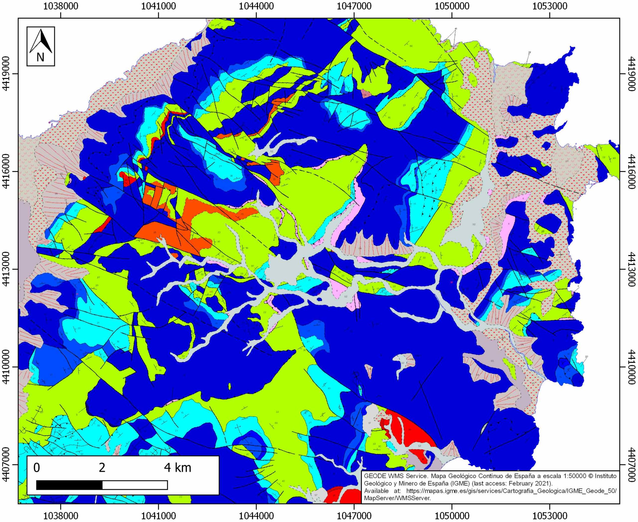
| IGME Geological Map (MAGNA50) Sheet number | 672-Arta. [link] |
| Other Maps #1 (source) | Fornós, J. J., Ferrer, B. G., 1995. Litologia i tectònica del carst de Mallorca. In El Carst i les coves de Mallorca. (pp. 27-43). Societat d’Història Natural de les Balears. [link] |
| Other Maps #2 (source) | Rosales, I., Barnolas, A., López-García, J. M., Sevillano, A., 2021. Strontium isotope stratigraphy (SIS) dating of the Bathonian regression in western Tethys (Mallorca island). Journal of Iberian Geology, 1-18. [link] |
| Other related references #1 | Capó, A., Garcia, C., 2019. Basin filling evolution of the central basins of Mallorca since the Pliocene. Basin Research, 31(5), 948-966. [link] |
| Other related references #2 | Casas, J. M., Sàbat, F., 1987. An example of three-dimensional analysis of thrust-related tectonites. Journal of structural geology, 9(5-6), 647-657. [link] |
| Other related references #3 | Fornós, J. J., Ginés, À., Ginés, J., Gràcia, F., Merino, A., 2019. Littoral Endokarst from Mallorca Island (Western Mediterranean). In The Spanish Coastal Systems (pp. 143-166). Springer, Cham. [link] |
| Other related references #4 | n.a. |
Well and Seismic Data
| UNIQUE_ID | 133 |
| Seismic survey name #1 | |
| Across structure? #1 | |
| Seismic profile ID (IGME) #1 | |
| Seismic profile code #1 | |
| Seismic profile name #1 | |
| Seismic survey year #1 | |
| Data repository #1 | |
| Length (km) #1 | |
| Seismic survey name #2 | |
| Across structure? #2 | |
| Seismic profile ID (IGME) #2 | |
| Seismic profile code #2 | |
| Seismic profile name #2 | |
| Seismic survey year #2 | |
| Data repository #2 | |
| Length (km) #2 | |
| Seismic survey name #3 | |
| Across structure? #3 | |
| Seismic profile ID (IGME) #3 | |
| Seismic profile code #3 | |
| Seismic profile name #3 | |
| Seismic survey year #3 | |
| Data repository #3 | |
| Length (km) #3 | |
| Seismic survey name #4 | |
| Across structure? #4 | |
| Seismic profile ID (IGME) #4 | |
| Seismic profile code #4 | |
| Seismic profile name #4 | |
| Seismic survey year #4 | |
| Data repository #4 | |
| Length (km) #4 | |
| Seismic survey name #5 | |
| Across structure? #5 | |
| Seismic profile ID (IGME) #5 | |
| Seismic profile code #5 | |
| Seismic profile name #5 | |
| Seismic survey year #5 | |
| Data repository #5 | |
| Length (km) #5 | |
| Seismic survey name #6 | |
| Across structure? #6 | |
| Seismic profile ID (IGME) #6 | |
| Seismic profile code #6 | |
| Seismic profile name #6 | |
| Seismic survey year #6 | |
| Data repository #6 | |
| Length (km) #6 | |
| Seismic survey name #7 | |
| Across structure? #7 | |
| Seismic profile ID (IGME) #7 | |
| Seismic profile code #7 | |
| Seismic profile name #7 | |
| Seismic survey year #7 | |
| Data repository #7 | |
| Length (km) #7 | |
| Seismic survey name #8 | |
| Across structure? #8 | |
| Seismic profile ID (IGME) #8 | |
| Seismic profile code #8 | |
| Seismic profile name #8 | |
| Seismic survey year #8 | |
| Data repository #8 | |
| Length (km) #8 | |
| Seismic survey name #9 | |
| Across structure? #9 | |
| Seismic profile ID (IGME) #9 | |
| Seismic profile code #9 | |
| Seismic profile name #9 | |
| Seismic survey year #9 | |
| Data repository #9 | |
| Length (km) #9 | |
| Seismic survey name #10 | |
| Across structure? #10 | |
| Seismic profile ID (IGME) #10 | |
| Seismic profile code #10 | |
| Seismic profile name #10 | |
| Seismic survey year #10 | |
| Data repository #10 | |
| Length (km) #10 | |
| Seismic survey name #11 | |
| Across structure? #11 | |
| Seismic profile ID (IGME) #11 | |
| Seismic profile code #11 | |
| Seismic profile name #11 | |
| Seismic survey year #11 | |
| Data repository #11 | |
| Length (km) #11 | |
| Seismic survey name #12 | |
| Across structure? #12 | |
| Seismic profile ID (IGME) #12 | |
| Seismic profile code #12 | |
| Seismic profile name #12 | |
| Seismic survey year #12 | |
| Data repository #12 | |
| Length (km) #12 | |
| Seismic survey name #13 | |
| Across structure? #13 | |
| Seismic profile ID (IGME) #13 | |
| Seismic profile code #13 | |
| Seismic profile name #13 | |
| Seismic survey year #13 | |
| Data repository #13 | |
| Length (km) #13 | |
| Seismic survey name #14 | |
| Across structure? #14 | |
| Seismic profile ID (IGME) #14 | |
| Seismic profile code #14 | |
| Seismic profile name #14 | |
| Seismic survey year #14 | |
| Data repository #14 | |
| Length (km) #14 | |
| Seismic survey name #15 | |
| Across structure? #15 | |
| Seismic profile ID (IGME) #15 | |
| Seismic profile code #15 | |
| Seismic profile name #15 | |
| Seismic survey year #15 | |
| Data repository #15 | |
| Length (km) #15 | |
| Seismic survey name #16 | |
| Across structure? #16 | |
| Seismic profile ID (IGME) #16 | |
| Seismic profile code #16 | |
| Seismic profile name #16 | |
| Seismic survey year #16 | |
| Data repository #16 | |
| Length (km) #16 | |
| Seismic survey name #17 | |
| Across structure? #17 | |
| Seismic profile ID (IGME) #17 | |
| Seismic profile code #17 | |
| Seismic profile name #17 | |
| Seismic survey year #17 | |
| Data repository #17 | |
| Length (km) #17 | |
| Seismic survey name #18 | |
| Across structure? #18 | |
| Seismic profile ID (IGME) #18 | |
| Seismic profile code #18 | |
| Seismic profile name #18 | |
| Seismic survey year #18 | |
| Data repository #18 | |
| Length (km) #18 | |
| Seismic survey name #19 | |
| Across structure? #19 | |
| Seismic profile ID (IGME) #19 | |
| Seismic profile code #19 | |
| Seismic profile name #19 | |
| Seismic survey year #19 | |
| Data repository #19 | |
| Length (km) #19 | |
| Seismic survey name #20 | |
| Across structure? #20 | |
| Seismic profile ID (IGME) #20 | |
| Seismic profile code #20 | |
| Seismic profile name #20 | |
| Seismic survey year #20 | |
| Data repository #20 | |
| Length (km) #20 | |
| Seismic survey name #21 | |
| Across structure? #21 | |
| Seismic profile ID (IGME) #21 | |
| Seismic profile code #21 | |
| Seismic profile name #21 | |
| Seismic survey year #21 | |
| Data repository #21 | |
| Length (km) #21 | |
| Borehole name #1 | |
| Company #1 | |
| Traget #1 | |
| Across structure? #1 | |
| Borehole name #2 | |
| Company #2 | |
| Traget #2 | |
| Across structure? #2 | |
| Borehole name #3 | |
| Company #3 | |
| Traget #3 | |
| Across structure? #3 | |
| Borehole name #4 | |
| Company #4 | |
| Traget #4 | |
| Across structure? #4 | |
| Borehole name #5 | |
| Company #5 | |
| Traget #5 | |
| Across structure? #5 | |
| Borehole name #6 | |
| Company #6 | |
| Traget #6 | |
| Across structure? #6 | |
| Borehole name #7 | |
| Company #7 | |
| Traget #7 | |
| Across structure? #7 | |
| Borehole name #8 | |
| Company #8 | |
| Traget #8 | |
| Across structure? #8 | |
| Borehole name #9 | |
| Company #9 | |
| Traget #9 | |
| Across structure? #9 | |
| Borehole name #10 | |
| Company #10 | |
| Traget #10 | |
| Across structure? #10 | |
| Borehole name #11 | |
| Company #11 | |
| Traget #11 | |
| Across structure? #11 | |
| Borehole name #12 | |
| Company #12 | |
| Traget #12 | |
| Across structure? #12 | |
| Borehole name #13 | |
| Company #13 | |
| Traget #13 | |
| Across structure? #13 | |
| Borehole name #14 | |
| Company #14 | |
| Traget #14 | |
| Across structure? #14 | |
| Borehole name #15 | |
| Company #15 | |
| Traget #15 | |
| Across structure? #15 |
Geographical Data (EPSG:4326 - WGS 84)
| UNIQUE_ID | 133 |
| X Centroid (Structure shape) | 3.388293 |
| Y Centroid (Structure shape) | 3.388293 |
| Xmin (Structure shape) | 3.324687 |
| Xmax (Structure shape) | 3.449338 |
| Ymin (Structure shape) | 39.679728 |
| Ymax (Structure shape) | 39.725544 |
| Xmin seismic line #1 | |
| Xmax seismic line #1 | |
| Ymin seismic line #1 | |
| Ymax seismic line #1 | |
| Xmin seismic line #2 | |
| Xmax seismic line #2 | |
| Ymin seismic line #2 | |
| Ymax seismic line #2 | |
| Xmin seismic line #3 | |
| Xmax seismic line #3 | |
| Ymin seismic line #3 | |
| Ymax seismic line #3 | |
| Xmin seismic line #4 | |
| Xmax seismic line #4 | |
| Ymin seismic line #4 | |
| Ymax seismic line #4 | |
| Xmin seismic line #5 | |
| Xmax seismic line #5 | |
| Ymin seismic line #5 | |
| Ymax seismic line #5 | |
| Xmin seismic line #6 | |
| Xmax seismic line #6 | |
| Ymin seismic line #6 | |
| Ymax seismic line #6 | |
| Xmin seismic line #7 | |
| Xmax seismic line #7 | |
| Ymin seismic line #7 | |
| Ymax seismic line #7 | |
| Xmin seismic line #8 | |
| Xmax seismic line #8 | |
| Ymin seismic line #8 | |
| Ymax seismic line #8 | |
| Xmin seismic line #9 | |
| Xmax seismic line #9 | |
| Ymin seismic line #9 | |
| Ymax seismic line #9 | |
| Xmin seismic line #10 | |
| Xmax seismic line #10 | |
| Ymin seismic line #10 | |
| Ymax seismic line #10 | |
| Xmin seismic line #11 | |
| Xmax seismic line #11 | |
| Ymin seismic line #11 | |
| Ymax seismic line #11 | |
| Xmin seismic line #12 | |
| Xmax seismic line #12 | |
| Ymin seismic line #12 | |
| Ymax seismic line #12 | |
| Xmin seismic line #13 | |
| Xmax seismic line #13 | |
| Ymin seismic line #13 | |
| Ymax seismic line #13 | |
| Xmin seismic line #14 | |
| Xmax seismic line #14 | |
| Ymin seismic line #14 | |
| Ymax seismic line #14 | |
| Xmin seismic line #15 | |
| Xmax seismic line #15 | |
| Ymin seismic line #15 | |
| Ymax seismic line #15 | |
| Xmin seismic line #16 | |
| Xmax seismic line #16 | |
| Ymin seismic line #16 | |
| Ymax seismic line #16 | |
| Xmin seismic line #17 | |
| Xmax seismic line #17 | |
| Ymin seismic line #17 | |
| Ymax seismic line #17 | |
| Xmin seismic line #18 | |
| Xmax seismic line #18 | |
| Ymin seismic line #18 | |
| Ymax seismic line #18 | |
| Xmin seismic line #19 | |
| Xmax seismic line #19 | |
| Ymin seismic line #19 | |
| Ymax seismic line #19 | |
| Xmin seismic line #20 | |
| Xmax seismic line #20 | |
| Ymin seismic line #20 | |
| Ymax seismic line #20 | |
| Xmin seismic line #21 | |
| Xmax seismic line #21 | |
| Ymin seismic line #21 | |
| Ymax seismic line #21 | |
| X borehole #1 | |
| Y borehole #1 | |
| X borehole #2 | |
| Y borehole #2 | |
| X borehole #3 | |
| Y borehole #3 | |
| X borehole #4 | |
| Y borehole #4 | |
| X borehole #5 | |
| Y borehole #5 | |
| X borehole #6 | |
| Y borehole #6 | |
| X borehole #7 | |
| Y borehole #7 | |
| X borehole #8 | |
| Y borehole #8 | |
| X borehole #9 | |
| Y borehole #9 | |
| X borehole #10 | |
| Y borehole #10 | |
| X borehole #11 | |
| Y borehole #11 | |
| X borehole #12 | |
| Y borehole #12 | |
| X borehole #13 | |
| Y borehole #13 | |
| X borehole #14 | |
| Y borehole #14 | |
| X borehole #15 | |
| Y borehole #15 |

