General Information
| Structure type | Evaporite-cored anticline |
| Deformed/Undeformed | Deformed |
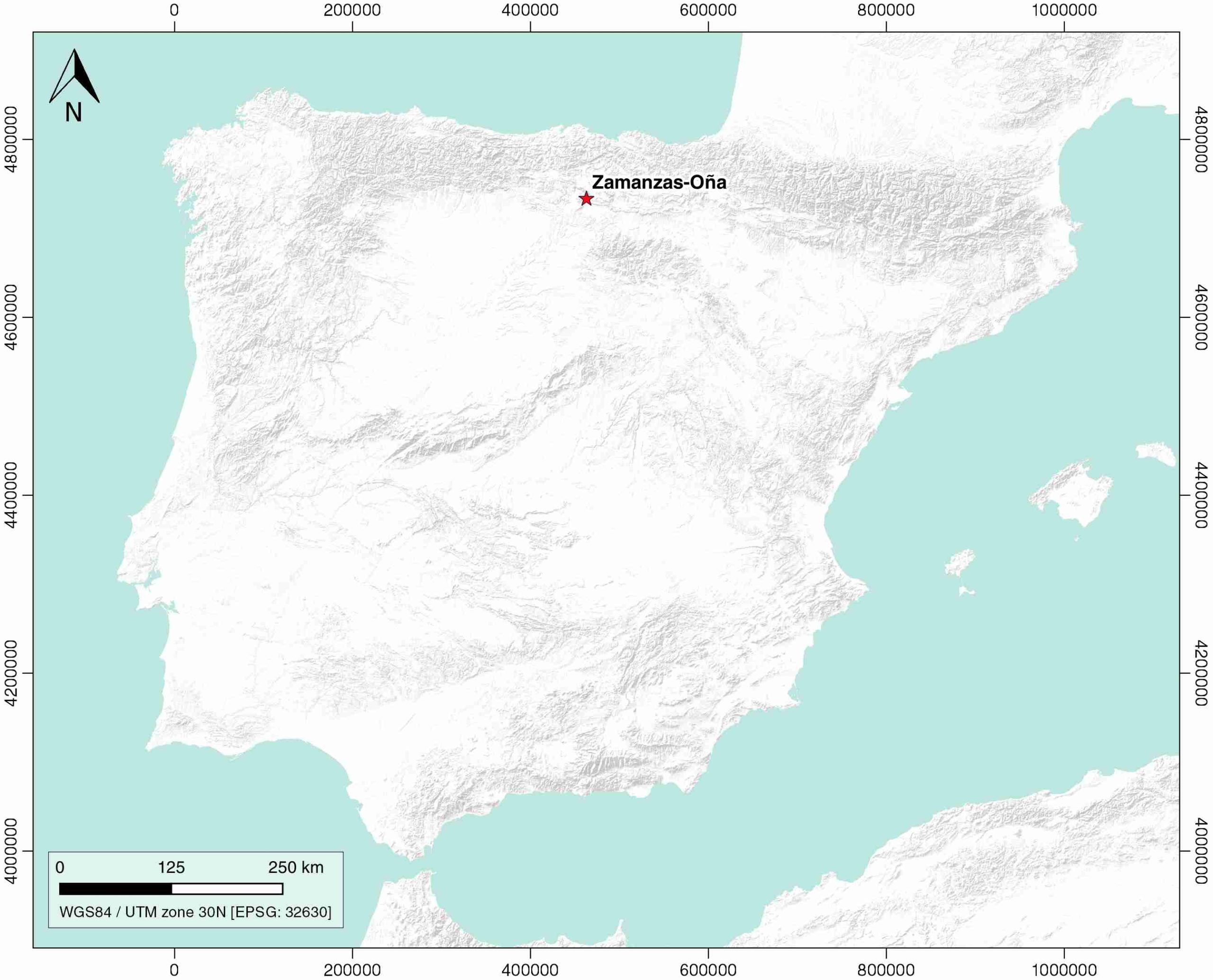
| Geological Setting | Basque-Cantabrian Basin, Burgalesa Platform |
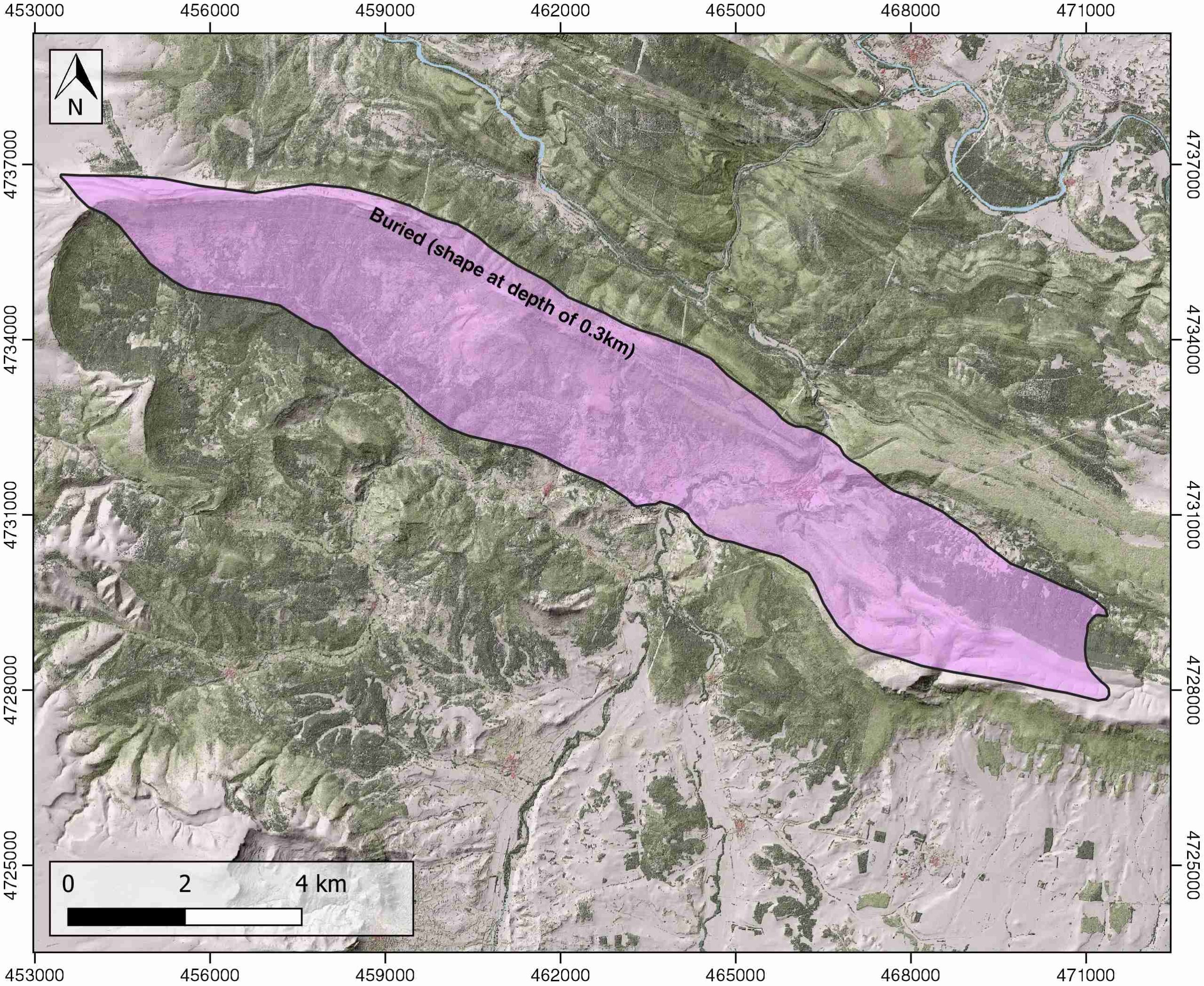
| Outcropping/buried | Buried |
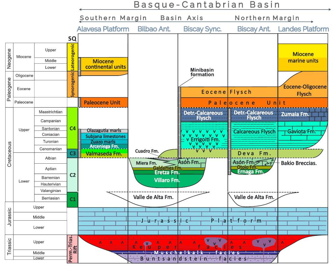
| Evaporite unit/s name | Keuper facies |
| Evaporite unit/s age | Carnian-Rhaetian (Upper Triassic) |
| Evaporite unit/s origin | Marine |
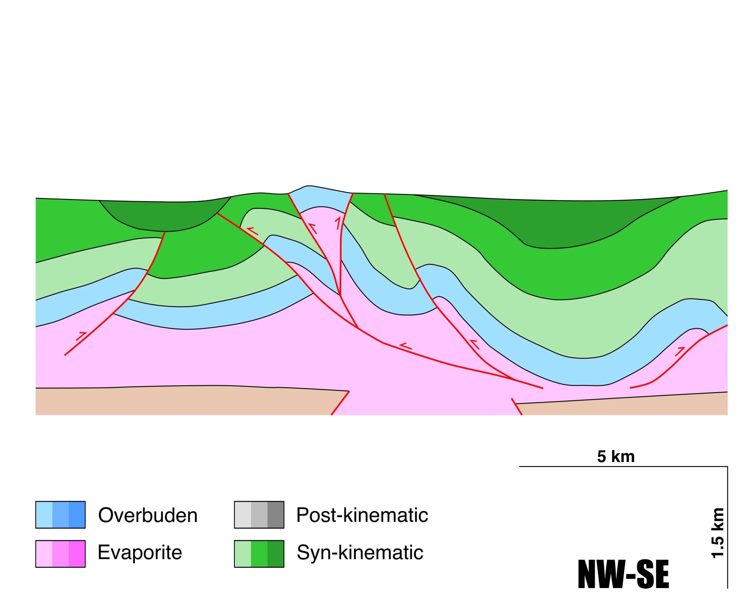
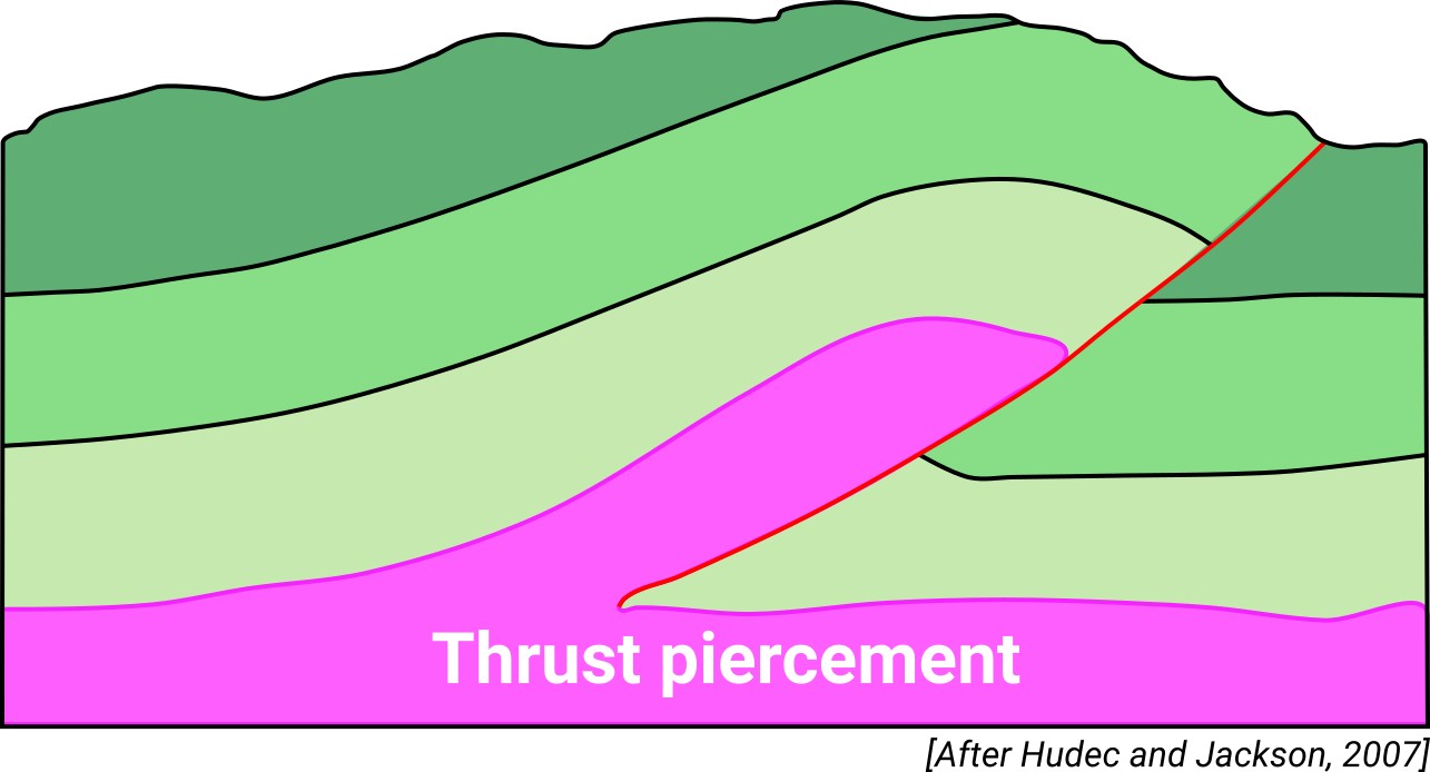
| Classif. (Hudec and Jackson, 2009) | Ductile piercement, Thrust piercement |
| Classif. (Jackson and Talbot, 1986) | Salt anticline |
| Age of evaporite flow or deformation (when deformed) | Oligocene to Miocene, Upper Jurassic to Lower Cretaceous |
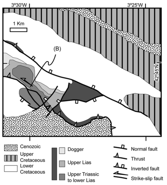
| Other comments | Interpreted as an halokinetic structure subsequently inverted during the main Alpine compressional stage (see Cámara, 2017). Surface-exposed analogue of the Ayoluengo oil field. |
Generic Data
| Unique ID | 110 |
| Name | Zamanzas-Oña |
| Structure type | Evaporite-cored anticline |
| Deformed/Undeformed | Deformed |
| Buried/Outcropping | Buried |
| Geological setting | Basque-Cantabrian Basin |
| Geological Regional Setting | Burgalesa Platform |
| Evaporite unit/s name | Keuper facies |
| Evaporite unit/s age | Carnian-Rhaetian (Upper Triassic) |
| Evaporite unit/s era | Mesozoic |
| Evaporite unit/s origin | Marine |
| Evaporite unit/s composition | Marlstone-Gypsum-Claystone-Halite |
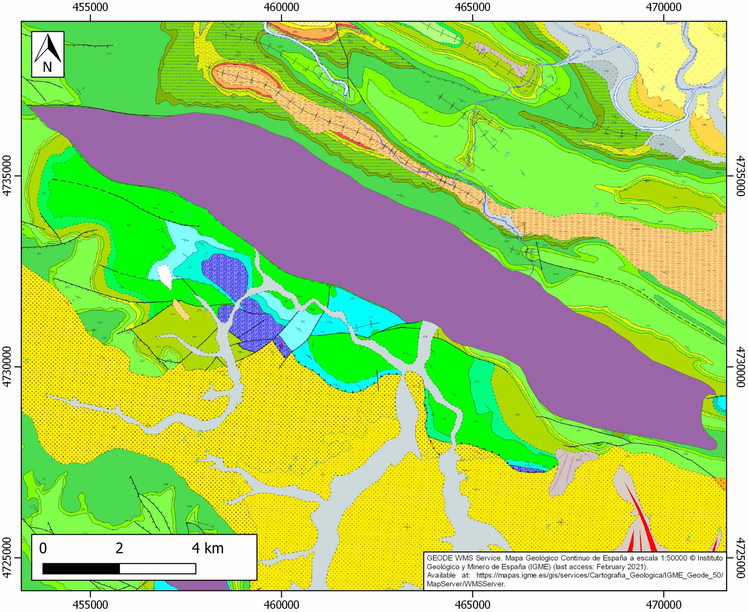
| Post-kinematic unit/s (or post-evaporite units when evaporites are undeformed) | Miocene (Alfaro and Tudela Fms., sandstones and conglomerates) ; Quaternary (alluvial and colluvial detrital deposits) |
| Post-kinematic unit/s age (or post-evaporite units when evaporites are undeformed) | Miocene-Holocene |
| Classification (Hudec and Jackson, 2009) | Thrust piercement / Ductile piercement |
| Classification (Jackson and Talbot, 1986) | Salt anticline |
| Mining activity? | Y |
| Mining activity start | – |
| Mining activity end | – |
| Mining galleries? | – |
| Mining products | Ornamental limestone |
| Mining sub-products | – |
| Evaporite flow? | Y |
| Age of evaporite flow | Upper Jurassic-Albian (early stage, halokinesis and salt diapirism) Upper Oligocene-Miocene (main inversion stage) |
| Flow or deformation triggering mechanisms | Extensional tectonics (early stage) ; Alpine compression and tectonic inversion of extensional raft and roller structures (main inversion stage) |
| Flow-linked structures? | Y |
| Halokinetic structures | Thrust faults / anticline-syncline folding / Low-angle unconformities |
| Post-evaporite and pre-kinematic unit/s (overbuden) | Jurassic (dolostones, marls and oolitic limestones) ; Upper Cretaceous (sandstones, marlstones, limestones, marly limestones and calcarenites) ; Palaeocene-Eocene (dolostones, sandstones, limestones, marlstones and calcarenites) ; Lower Oligocene (red claystones and sandstones) |
| Syn-kinematic unit/s | Upper Jurassic-Lower Cretaceous (Purbeck facies, limestones and claystones) ; Lower Cretaceous (Weald facies, shales, sandstones and conglomerates) ; Aptian-Albian (Escucha Fm., shales, sandstones and marls) Upper Oligocene-Miocene (Pancorbo Fm., red claystones, conglomerates and lacustrine limestones) ; Mid Miocene (Altabble and Buerba Fms., grey marlstones, red claystones, sandstones and conglomerates) |
| Available seismic profiles | VAL-6 / VAL-3 / BB-1 / VAL-2 / VAL-3 / VAL-6 / VAL84-02 / PR-63 / VAL84-03 / BB-1 / VAL-4 / VAL5 / C-10 / BG-10 / VAL84-06 |
| Available boreholes | Private access (Cepsa and Vacum Oil Co.) |
| Additional comments | Interpreted as an halokinetic structure subsequently inverted during the main Alpine compressional stage (see Cámara, 2017). Surface-exposed analogue of the Ayoluengo oil field, |
Mining Data
| UNIQUE_ID | 110 |
| Minning exploitations within <2km? | Y |
| Historical/Active | Active |
| Exploitation name #1 | ALEJANDRO II |
| Exploitation ID (Spanish National Mining Cadastre) #1 | 4367 |
| Municipality #1 | Merindad de Valdivielso |
| Province #1 | BURGOS |
| Company #1 | ORNAMENTALES DEL NORTE DE CASTILLA, SL |
| Main minning Products #1 | Ornamental limestone |
| Exploitation name #2 | |
| Exploitation ID (Spanish National Mining Cadastre) #2 | |
| Municipality #2 | |
| Province #2 | |
| Company #2 | |
| Main minning Products #2 | |
| Exploitation name #3 | |
| Exploitation ID (Spanish National Mining Cadastre) #3 | |
| Municipality #3 | |
| Province #3 | |
| Company #3 | |
| Main minning Products #3 |
Quantitative Data
| UNIQUE_ID | 110 |
| Outcropping area (km2) | Buried |
| Horizontal intersection area (km2) (when buried) | 43.70186 |
| Depth of intersection area (km2) (when buried) | 0.2 |
| Max. Width (Km) | 19.8929066 |
| Max. Length (Km) | 4.12824349 |
| Max. Evaporites thickness (km) | 2.9 |
| Max. Deformation age (Ma) | 148 |
| Min. Deformation age (Ma) | 20 |
| Deformation stages | 2 |
Reference Data
| UNIQUE_ID | 110 |
| Section source | Cámara, P., 2017. Salt and Strike-Slip Tectonics as Main Drivers in the Structural Evolution of the Basque-Cantabrian Basin, Spain. In Permo-Triassic Salt Provinces of Europe, North Africa and the Atlantic Margins (pp. 371-393). Elsevier. [link] |
| Well / Borehole availability #1 | Carola, E., Muñoz, J. A., Roca, E., 2015. The transition from thick-skinned to thin-skinned tectonics in the Basque-Cantabrian Pyrenees: The Burgalesa Platform and surroundings. International Journal of Earth Sciences, 104(8), 2215-2239. [link] |
| Well / Borehole availability #2 | n.a. |
| Available data (Stratigraphy) #1 | Tavani, S., Granado, P., 2015. Along‐strike evolution of folding, stretching and breaching of supra‐salt strata in the Plataforma Burgalesa extensional forced fold system (northern Spain). Basin Research, 27(4), 573-585. [link] |
| Available data (Stratigraphy) #2 | Tavani, S., Balsamo, F., Granado, P., 2018. Petroleum system in supra-salt strata of extensional forced-folds: a case-study from the Basque-Cantabrian basin (Spain). Marine and Petroleum Geology, 96, 315-330. [link] |
| Available data (Stratigraphy) #3 | Pedrera, A., García‐Senz, J., Ayala, C., Ruiz‐Constán, A., Rodríguez‐Fernández, L. R., Robador, A., González Menéndez, L., 2017. Reconstruction of the exhumed mantle across the North Iberian Margin by crustal‐scale 3‐D gravity inversion and geological cross section. Tectonics, 36, 3155-3177. [link] |
| Available data (Stratigraphy) #4 | Cámara, P., Flinch, J. F., 2017. The southern Pyrenees: a salt-based fold-and-thrust belt. In Juan I. Soto, Joan F. Flinch, Gabor Tari (eds.): Permo-Triassic Salt Provinces of Europe, North Africa and the Atlantic Margins, Elsevier, pp. 395-415. [link] |
| Available data (Stratigraphy) #5 | n.a. |
| Available data (Stratigraphy) #6 | n.a. |
| Regional Stratigraphy | Pedrera, A., García‐Senz, J., Ayala, C., Ruiz‐Constán, A., Rodríguez‐Fernández, L. R., Robador, A., González Menéndez, L., 2017. Reconstruction of the exhumed mantle across the North Iberian Margin by crustal‐scale 3‐D gravity inversion and geological cross section. Tectonics, 36, 3155-3177. [link] |
| Seismic data availability #1 | Carola, E., Tavani, S., Ferrer, O., Granado, P., Quintà, A., Butillé, M., Muñoz, J. A., 2013. Along-strike extrusion at the transition between thin-and thick-skinned domains in the Pyrenean Orogen (northern Spain). Geological Society, London, Special Publications, 377(1), 119-140. [link] |
| Seismic data availability #2 | Carola, E., Muñoz, J. A., Roca, E., 2015. The transition from thick-skinned to thin-skinned tectonics in the Basque-Cantabrian Pyrenees: The Burgalesa Platform and surroundings. International Journal of Earth Sciences, 104(8), 2215-2239. [link] |
| Seismic data availability #3 | Cámara, P., 2017. Salt and Strike-Slip Tectonics as Main Drivers in the Structural Evolution of the Basque-Cantabrian Basin, Spain. In Permo-Triassic Salt Provinces of Europe, North Africa and the Atlantic Margins (pp. 371-393). Elsevier. [link] |
| Available data (Structure) #1 | Carola, E., Muñoz, J. A., Roca, E., 2015. The transition from thick-skinned to thin-skinned tectonics in the Basque-Cantabrian Pyrenees: The Burgalesa Platform and surroundings. International Journal of Earth Sciences, 104(8), 2215-2239. [link] |
| Available data (Structure) #2 | Pedrera, A., García‐Senz, J., Ayala, C., Ruiz‐Constán, A., Rodríguez‐Fernández, L. R., Robador, A., González Menéndez, L., 2017. Reconstruction of the exhumed mantle across the North Iberian Margin by crustal‐scale 3‐D gravity inversion and geological cross section. Tectonics, 36, 3155-3177. [link] |
| Available data (Structure) #3 | Pinto, V., Casas, A., Rivero, L., Torne, M., 2005. 3D gravity modeling of the Triassic salt diapirs of the Cubeta Alavesa (northern Spain). Tectonophysics, 405, 65-75. [link] |
| Available data (Structure) #4 | Muñoz, J. A., 2019. Alpine Orogeny: Deformation and Structure in the Northern Iberian Margin (Pyrenees sl). In (Quesada C., Oliveira J., eds.): The Geology of Iberia: A Geodynamic Approach, p. 433-451. Regional Geology Reviews, Springer, Cham. [link] |
| Available data (Structure) #5 | Carola, E., Tavani, S., Ferrer, O., Granado, P., Quintà, A., Butillé, M., Muñoz, J. A., 2013. Along-strike extrusion at the transition between thin-and thick-skinned domains in the Pyrenean Orogen (northern Spain). Geological Society, London, Special Publications, 377(1), 119-140. [link] |
| Available data (Structure) #6 | Cámara, P., 2017. Salt and Strike-Slip Tectonics as Main Drivers in the Structural Evolution of the Basque-Cantabrian Basin, Spain. In Permo-Triassic Salt Provinces of Europe, North Africa and the Atlantic Margins (pp. 371-393). Elsevier. [link] |
| Available data (Analogue modelling) #1 | n.a. |
| Available data (Analogue modelling) #2 | n.a. |
| Available data (Analogue modelling) #3 | n.a. |
| Available data (Gravimetry – Tomography) #1 | Pedrera, A., García‐Senz, J., Ayala, C., Ruiz‐Constán, A., Rodríguez‐Fernández, L. R., Robador, A., González Menéndez, L., 2017. Reconstruction of the exhumed mantle across the North Iberian Margin by crustal‐scale 3‐D gravity inversion and geological cross section. Tectonics, 36, 3155-3177. [link] |
| Available data (Gravimetry – Tomography) #2 | Pinto, V., Casas, A., Rivero, L., Torne, M., 2005. 3D gravity modeling of the Triassic salt diapirs of the Cubeta Alavesa (northern Spain). Tectonophysics, 405, 65-75. [link] |
| Available data (Gravimetry – Tomography) #3 | Ayala, C., Bohoyo, F., Maestro, A., Reguera, M. I., Torne, M., Rubio, F., Fernández, M., García-Lobón, J. L., 2016. Updated Bouguer anomalies of the Iberian Peninsula: a new perspective to interpret the regional geology. Journal of Maps, 12(5), 1089-1092. [link] |
| Available data (Geochemistry) #1 | Ortí, F., García-Veigas, J., Rossell, L., Jurado, M. J., Utrilla, R., 1996. Formaciones salinas de las cuencas triásicas en la Península Ibérica: Caracterización Petrológica y Geoquímica. Cuadernos de Geología Ibérica, 20, 13-35. [link] |
| Available data (Geochemistry) #2 | Iribar, V., Ábalos, B. 2011. The geochemical and isotopic record of evaporite recycling in spas and salterns of the Basque Cantabrian basin, Spain. Applied geochemistry, 26, 1315-1329. [link] |
| Available data (Geochemistry) #3 | Marín, P., Márquez, G., Gallego, J. R., Permanyer, A., 2014. Characterization of asphaltic oil occurrences from the southeastern margin of the Basque-Cantabrian Basin, Spain. Geologica Acta, 12(4), 327-342. [link] |
| Available data (Geochemistry) #4 | n.a. |
| Available data (Petrophysics) #1 | Llamas, B., Castañeda, M. C., Laín, C., Pous, J., 2017. Study of the Basque–Cantabrian basin as a suitable region for the implementation of an energy storage system based on compressed air energy storage (CAES). Environmental Earth Sciences, 76(5), 204. [link] |
| Available data (Petrophysics) #2 | Soto, R., Beamud, E., Roca, E., Carola, E., Almar, Y., 2017. Distinguishing the effect of diapir growth on magnetic fabrics of syn-diapiric overburden rocks: Basque-Cantabrian basin, Northern Spain. Terra Nova 29, 191-201. [link] |
| IGME Geological Map (MAGNA50) Sheet number | 136-Oña. [link] |
| Other Maps #1 (source) | Perona, J., 2016. Mineralizaciones de Pb-Zn asociadas a los diapiros de Murguía y Orduña (Cuenca Vasco-Cantábrica) [PhD thesis]: Barcelona, Universitat de Barcelona, 281 pp. [link] |
| Other Maps #2 (source) | Carola, E., Tavani, S., Ferrer, O., Granado, P., Quintà, A., Butillé, M., Muñoz, J. A., 2013. Along-strike extrusion at the transition between thin-and thick-skinned domains in the Pyrenean Orogen (northern Spain). Geological Society, London, Special Publications, 377(1), 119-140. [link] |
| Other related references #1 | Comet, J. N., 2018. Ayoluengo’s history–Spain’s only onshore oil field. Geological Society, London, Special Publications, 465(1), 333-344. [link] |
| Other related references #2 | Martín-Chivelet, J., López-Gómez, J., Aguado, R., Arias, C., Arribas, J., Arribas, M. E., … , Casas-Sainz, A., 2019. The Late Jurassic–Early Cretaceous Rifting. In (Quesada C., Oliveira J., eds.): The Geology of Iberia: A Geodynamic Approach. Regional Geology Reviews. Springer, Cham. [link] |
| Other related references #3 | Ábalos, B., 2016. Geologic map of the Basque-Cantabrian Basin and a new tectonic interpretation of the Basque Arc. International Journal of Earth Sciences, 105, 2327-2354. [link] |
| Other related references #4 | Tavani, S., 2012. Plate kinematics in the Cantabrian domain of the Pyrenean orogen. Solid Earth, 3(2), 265. [link] |
Well and Seismic Data
| UNIQUE_ID | 110 |
| Seismic survey name #1 | 7C2-VAL |
| Across structure? #1 | Y |
| Seismic profile ID (IGME) #1 | 9501 |
| Seismic profile code #1 | 14074 |
| Seismic profile name #1 | VAL-6 |
| Seismic survey year #1 | 1981 |
| Data repository #1 | SIGEOF Data Catalogue (Section available under request). ©Instituto Geológico y Minero de España (IGME). https://info.igme.es/SIGEOF/ |
| Length (km) #1 | 10.40 |
| Seismic survey name #2 | 7C3-VAL |
| Across structure? #2 | Y |
| Seismic profile ID (IGME) #2 | 9603 |
| Seismic profile code #2 | 14176 |
| Seismic profile name #2 | VAL-3 |
| Seismic survey year #2 | 1981 |
| Data repository #2 | SIGEOF Data Catalogue (Section available under request). ©Instituto Geológico y Minero de España (IGME). https://info.igme.es/SIGEOF/ |
| Length (km) #2 | 30.49 |
| Seismic survey name #3 | 7C2-BB1 |
| Across structure? #3 | Y |
| Seismic profile ID (IGME) #3 | 9464 |
| Seismic profile code #3 | 14037 |
| Seismic profile name #3 | BB-1 |
| Seismic survey year #3 | 1977 |
| Data repository #3 | SIGEOF Data Catalogue (Section available under request). ©Instituto Geológico y Minero de España (IGME). https://info.igme.es/SIGEOF/ |
| Length (km) #3 | 27.76 |
| Seismic survey name #4 | 7C3-VAL |
| Across structure? #4 | Y |
| Seismic profile ID (IGME) #4 | 9604 |
| Seismic profile code #4 | 14177 |
| Seismic profile name #4 | VAL-2 |
| Seismic survey year #4 | 1981 |
| Data repository #4 | SIGEOF Data Catalogue (Section available under request). ©Instituto Geológico y Minero de España (IGME). https://info.igme.es/SIGEOF/ |
| Length (km) #4 | 31.70 |
| Seismic survey name #5 | 7C3-VAL |
| Across structure? #5 | N (within 3km) |
| Seismic profile ID (IGME) #5 | 9603 |
| Seismic profile code #5 | 14176 |
| Seismic profile name #5 | VAL-3 |
| Seismic survey year #5 | 1981 |
| Data repository #5 | SIGEOF Data Catalogue (Section available under request). ©Instituto Geológico y Minero de España (IGME). https://info.igme.es/SIGEOF/ |
| Length (km) #5 | 30.49 |
| Seismic survey name #6 | 7C2-VAL |
| Across structure? #6 | N (within 3km) |
| Seismic profile ID (IGME) #6 | 9501 |
| Seismic profile code #6 | 14074 |
| Seismic profile name #6 | VAL-6 |
| Seismic survey year #6 | 1981 |
| Data repository #6 | SIGEOF Data Catalogue (Section available under request). ©Instituto Geológico y Minero de España (IGME). https://info.igme.es/SIGEOF/ |
| Length (km) #6 | 10.40 |
| Seismic survey name #7 | 7C3-VAL84 |
| Across structure? #7 | N (within 3km) |
| Seismic profile ID (IGME) #7 | 9619 |
| Seismic profile code #7 | 14192 |
| Seismic profile name #7 | VAL84-02 |
| Seismic survey year #7 | 1984 |
| Data repository #7 | SIGEOF Data Catalogue (Section available under request). ©Instituto Geológico y Minero de España (IGME). https://info.igme.es/SIGEOF/ |
| Length (km) #7 | 7.45 |
| Seismic survey name #8 | 7C2-PR |
| Across structure? #8 | N (within 3km) |
| Seismic profile ID (IGME) #8 | 9491 |
| Seismic profile code #8 | 14064 |
| Seismic profile name #8 | PR-63 |
| Seismic survey year #8 | 1976 |
| Data repository #8 | SIGEOF Data Catalogue (Section available under request). ©Instituto Geológico y Minero de España (IGME). https://info.igme.es/SIGEOF/ |
| Length (km) #8 | 21.66 |
| Seismic survey name #9 | 7C3-VAL84 |
| Across structure? #9 | N (within 3km) |
| Seismic profile ID (IGME) #9 | 9618 |
| Seismic profile code #9 | 14191 |
| Seismic profile name #9 | VAL84-03 |
| Seismic survey year #9 | 1984 |
| Data repository #9 | SIGEOF Data Catalogue (Section available under request). ©Instituto Geológico y Minero de España (IGME). https://info.igme.es/SIGEOF/ |
| Length (km) #9 | 8.54 |
| Seismic survey name #10 | 7C2-BB1 |
| Across structure? #10 | N (within 3km) |
| Seismic profile ID (IGME) #10 | 9464 |
| Seismic profile code #10 | 14037 |
| Seismic profile name #10 | BB-1 |
| Seismic survey year #10 | 1977 |
| Data repository #10 | SIGEOF Data Catalogue (Section available under request). ©Instituto Geológico y Minero de España (IGME). https://info.igme.es/SIGEOF/ |
| Length (km) #10 | 27.76 |
| Seismic survey name #11 | 7C4-VAL |
| Across structure? #11 | N (within 3km) |
| Seismic profile ID (IGME) #11 | 9701 |
| Seismic profile code #11 | 14274 |
| Seismic profile name #11 | VAL-4 |
| Seismic survey year #11 | 1981 |
| Data repository #11 | SIGEOF Data Catalogue (Section available under request). ©Instituto Geológico y Minero de España (IGME). https://info.igme.es/SIGEOF/ |
| Length (km) #11 | 31.08 |
| Seismic survey name #12 | 7C4-VAL |
| Across structure? #12 | N (within 3km) |
| Seismic profile ID (IGME) #12 | 9700 |
| Seismic profile code #12 | 14273 |
| Seismic profile name #12 | VAL5 |
| Seismic survey year #12 | 1976 |
| Data repository #12 | SIGEOF Data Catalogue (Section available under request). ©Instituto Geológico y Minero de España (IGME). https://info.igme.es/SIGEOF/ |
| Length (km) #12 | 36.71 |
| Seismic survey name #13 | 7C-ST-92-92BIS |
| Across structure? #13 | N (within 3km) |
| Seismic profile ID (IGME) #13 | 12812 |
| Seismic profile code #13 | 17530 |
| Seismic profile name #13 | C-10 |
| Seismic survey year #13 | 1965 |
| Data repository #13 | SIGEOF Data Catalogue (Private access section). ©Instituto Geológico y Minero de España (IGME). https://info.igme.es/SIGEOF/ |
| Length (km) #13 | 16.61 |
| Seismic survey name #14 | 7C2-BG |
| Across structure? #14 | N (within 3km) |
| Seismic profile ID (IGME) #14 | 9485 |
| Seismic profile code #14 | 14058 |
| Seismic profile name #14 | BG-10 |
| Seismic survey year #14 | 1975 |
| Data repository #14 | SIGEOF Data Catalogue (Private access section). ©Instituto Geológico y Minero de España (IGME). https://info.igme.es/SIGEOF/ |
| Length (km) #14 | 23.95 |
| Seismic survey name #15 | 7C3-VAL84 |
| Across structure? #15 | N (within 3km) |
| Seismic profile ID (IGME) #15 | 9615 |
| Seismic profile code #15 | 14188 |
| Seismic profile name #15 | VAL84-06 |
| Seismic survey year #15 | 1984 |
| Data repository #15 | SIGEOF Data Catalogue (Private access section). ©Instituto Geológico y Minero de España (IGME). https://info.igme.es/SIGEOF/ |
| Length (km) #15 | 9.33 |
| Seismic survey name #16 | |
| Across structure? #16 | |
| Seismic profile ID (IGME) #16 | |
| Seismic profile code #16 | |
| Seismic profile name #16 | |
| Seismic survey year #16 | |
| Data repository #16 | |
| Length (km) #16 | |
| Seismic survey name #17 | |
| Across structure? #17 | |
| Seismic profile ID (IGME) #17 | |
| Seismic profile code #17 | |
| Seismic profile name #17 | |
| Seismic survey year #17 | |
| Data repository #17 | |
| Length (km) #17 | |
| Seismic survey name #18 | |
| Across structure? #18 | |
| Seismic profile ID (IGME) #18 | |
| Seismic profile code #18 | |
| Seismic profile name #18 | |
| Seismic survey year #18 | |
| Data repository #18 | |
| Length (km) #18 | |
| Seismic survey name #19 | |
| Across structure? #19 | |
| Seismic profile ID (IGME) #19 | |
| Seismic profile code #19 | |
| Seismic profile name #19 | |
| Seismic survey year #19 | |
| Data repository #19 | |
| Length (km) #19 | |
| Seismic survey name #20 | |
| Across structure? #20 | |
| Seismic profile ID (IGME) #20 | |
| Seismic profile code #20 | |
| Seismic profile name #20 | |
| Seismic survey year #20 | |
| Data repository #20 | |
| Length (km) #20 | |
| Seismic survey name #21 | |
| Across structure? #21 | |
| Seismic profile ID (IGME) #21 | |
| Seismic profile code #21 | |
| Seismic profile name #21 | |
| Seismic survey year #21 | |
| Data repository #21 | |
| Length (km) #21 | |
| Borehole name #1 | |
| Company #1 | |
| Traget #1 | |
| Across structure? #1 | |
| Borehole name #2 | |
| Company #2 | |
| Traget #2 | |
| Across structure? #2 | |
| Borehole name #3 | |
| Company #3 | |
| Traget #3 | |
| Across structure? #3 | |
| Borehole name #4 | |
| Company #4 | |
| Traget #4 | |
| Across structure? #4 | |
| Borehole name #5 | |
| Company #5 | |
| Traget #5 | |
| Across structure? #5 | |
| Borehole name #6 | |
| Company #6 | |
| Traget #6 | |
| Across structure? #6 | |
| Borehole name #7 | |
| Company #7 | |
| Traget #7 | |
| Across structure? #7 | |
| Borehole name #8 | |
| Company #8 | |
| Traget #8 | |
| Across structure? #8 | |
| Borehole name #9 | |
| Company #9 | |
| Traget #9 | |
| Across structure? #9 | |
| Borehole name #10 | |
| Company #10 | |
| Traget #10 | |
| Across structure? #10 | |
| Borehole name #11 | |
| Company #11 | |
| Traget #11 | |
| Across structure? #11 | |
| Borehole name #12 | |
| Company #12 | |
| Traget #12 | |
| Across structure? #12 | |
| Borehole name #13 | |
| Company #13 | |
| Traget #13 | |
| Across structure? #13 | |
| Borehole name #14 | |
| Company #14 | |
| Traget #14 | |
| Across structure? #14 | |
| Borehole name #15 | |
| Company #15 | |
| Traget #15 | |
| Across structure? #15 |
Geographical Data (EPSG:4326 - WGS 84)
| UNIQUE_ID | 110 |
| X Centroid (Structure shape) | -3.453795 |
| Y Centroid (Structure shape) | -3.453795 |
| Xmin (Structure shape) | -3.569191 |
| Xmax (Structure shape) | -3.349253 |
| Ymin (Structure shape) | 42.702334 |
| Ymax (Structure shape) | 42.782558 |
| Xmin seismic line #1 | -3.457909 |
| Xmax seismic line #1 | -3.391012 |
| Ymin seismic line #1 | 42.670758 |
| Ymax seismic line #1 | 42.749741 |
| Xmin seismic line #2 | -3.718311 |
| Xmax seismic line #2 | -3.402833 |
| Ymin seismic line #2 | 42.693631 |
| Ymax seismic line #2 | 42.830333 |
| Xmin seismic line #3 | -3.438081 |
| Xmax seismic line #3 | -3.309323 |
| Ymin seismic line #3 | 42.664739 |
| Ymax seismic line #3 | 42.862549 |
| Xmin seismic line #4 | -3.574504 |
| Xmax seismic line #4 | -3.487600 |
| Ymin seismic line #4 | 42.634813 |
| Ymax seismic line #4 | 42.911169 |
| Xmin seismic line #5 | -3.718311 |
| Xmax seismic line #5 | -3.402833 |
| Ymin seismic line #5 | 42.693631 |
| Ymax seismic line #5 | 42.830333 |
| Xmin seismic line #6 | -3.457909 |
| Xmax seismic line #6 | -3.391012 |
| Ymin seismic line #6 | 42.670758 |
| Ymax seismic line #6 | 42.749741 |
| Xmin seismic line #7 | -3.637138 |
| Xmax seismic line #7 | -3.586960 |
| Ymin seismic line #7 | 42.755896 |
| Ymax seismic line #7 | 42.811709 |
| Xmin seismic line #8 | -3.347824 |
| Xmax seismic line #8 | -3.244590 |
| Ymin seismic line #8 | 42.654250 |
| Ymax seismic line #8 | 42.831205 |
| Xmin seismic line #9 | -3.669490 |
| Xmax seismic line #9 | -3.577451 |
| Ymin seismic line #9 | 42.761075 |
| Ymax seismic line #9 | 42.797182 |
| Xmin seismic line #10 | -3.438081 |
| Xmax seismic line #10 | -3.309323 |
| Ymin seismic line #10 | 42.664739 |
| Ymax seismic line #10 | 42.862549 |
| Xmin seismic line #11 | -3.630459 |
| Xmax seismic line #11 | -3.581398 |
| Ymin seismic line #11 | 42.638067 |
| Ymax seismic line #11 | 42.911354 |
| Xmin seismic line #12 | -3.676216 |
| Xmax seismic line #12 | -3.296055 |
| Ymin seismic line #12 | 42.708186 |
| Ymax seismic line #12 | 42.873625 |
| Xmin seismic line #13 | -3.463094 |
| Xmax seismic line #13 | -3.375582 |
| Ymin seismic line #13 | 42.560030 |
| Ymax seismic line #13 | 42.691193 |
| Xmin seismic line #14 | -3.394924 |
| Xmax seismic line #14 | -3.343484 |
| Ymin seismic line #14 | 42.467344 |
| Ymax seismic line #14 | 42.679353 |
| Xmin seismic line #15 | -3.639947 |
| Xmax seismic line #15 | -3.575458 |
| Ymin seismic line #15 | 42.735492 |
| Ymax seismic line #15 | 42.804644 |
| Xmin seismic line #16 | |
| Xmax seismic line #16 | |
| Ymin seismic line #16 | |
| Ymax seismic line #16 | |
| Xmin seismic line #17 | |
| Xmax seismic line #17 | |
| Ymin seismic line #17 | |
| Ymax seismic line #17 | |
| Xmin seismic line #18 | |
| Xmax seismic line #18 | |
| Ymin seismic line #18 | |
| Ymax seismic line #18 | |
| Xmin seismic line #19 | |
| Xmax seismic line #19 | |
| Ymin seismic line #19 | |
| Ymax seismic line #19 | |
| Xmin seismic line #20 | |
| Xmax seismic line #20 | |
| Ymin seismic line #20 | |
| Ymax seismic line #20 | |
| Xmin seismic line #21 | |
| Xmax seismic line #21 | |
| Ymin seismic line #21 | |
| Ymax seismic line #21 | |
| X borehole #1 | |
| Y borehole #1 | |
| X borehole #2 | |
| Y borehole #2 | |
| X borehole #3 | |
| Y borehole #3 | |
| X borehole #4 | |
| Y borehole #4 | |
| X borehole #5 | |
| Y borehole #5 | |
| X borehole #6 | |
| Y borehole #6 | |
| X borehole #7 | |
| Y borehole #7 | |
| X borehole #8 | |
| Y borehole #8 | |
| X borehole #9 | |
| Y borehole #9 | |
| X borehole #10 | |
| Y borehole #10 | |
| X borehole #11 | |
| Y borehole #11 | |
| X borehole #12 | |
| Y borehole #12 | |
| X borehole #13 | |
| Y borehole #13 | |
| X borehole #14 | |
| Y borehole #14 | |
| X borehole #15 | |
| Y borehole #15 |

